 Selection of features
with a domain of specific variable values
Selection of features
with a domain of specific variable valuesDavid James, Michael Burkart, Mason J. Hewitt III
There is increasing public concern for the environmental effects of agriculture, especially the effects of herbicides and pesticides on water quality. The US Environmental Protection Agency and the US Department of Agriculture have undertaken research that will examine the ecological effects of agricultural chemicals in the midwestern United States at the watershed, ecoregion, and regional scales. One of the primary goals of this research is to provide a GIS-based resource characterization and analysis framework. This is needed to support the risk-assessment and decision-support functions affecting national agricultural policies. This goal will be accomplished through the development of a multi-scale resource analysis framework that will allow interaction between scientists and critical data bases, like the Natural Resource Conservation Service's (NRCS) National Resources Inventory (NRI).
The NRI Data Explorer provides a menu-based access tool to the NRI data base. This application uses the ArcInfo geographic information system to provide mapping and data base access capabilities. The NRI Data Explorer was written in the Arc macro language (AML) to take advantage of ArcInfo's spatial data handling tools and menuing capabilities to provide an easy-to-use graphic interface for querying the NRI data base and displaying the results.
This paper is a summary of the progress to date in developing the NRI Data Explorer; describes some of the application's important features; provides an example of how the application may be used; and establishes some goals for future research. Specific subheadings may be accessed directly by clicking on one of the following underlined links:

There is increasing public concern for the environmental effects of agriculture, particularly on water quality. Measurements of ground and surface water resources have provided empirical evidence that aquifers, streams, and reservoirs are receiving pesticides and plant nutrients used to increase agricultural productivity and surface water bodies are receiving large quantities of sediment derived from soil erosion. Research is underway, at the plot and field scale, to understand the processes by which chemicals move out of the soil and into water resources. As a complement to this local-scale research, the study of water and soil resources and agricultural management practices at the regional scale is necessary if we are to understand the complete context in which resources are modified by widely distributed agricultural activities.
At the regional scale it is possible to show a cumulative response of natural resources to agriculture. While it may not be possible to establish a direct link between causes and responses, it is possible, using regional scale interpretations, to define priority areas for research on cause and effect relationships. Also, because public policy on agriculture is generally made for very large areas it is useful to examine the spatial relationships among human and natural resource characteristics of agroecosystems at the regional scale.
Regionalization pertains to analyzing spatial features at similar scales to gain an understanding of patterns and the interaction among familiar features. The development of quantifiable or mappable patterns begins with a perception of the spatial affinity among features and recurrence of groups or combinations of features. These perceptions can be quantified by identifying a feature attribute or combination of attributes that logically simulate the patterns. Regional perspectives and analyses of agricultural systems are becoming increasingly possible with the growth of consistent data at similar scales and digital analytical and display techniques like geographic information systems (GIS).
The 12-state Midwest was selected for analysis because it is one of the most agriculturally productive regions in the Nation. In this region, intense agricultural production has been possible because of the quality and availability of natural resources and suitable topography. One requirement of this intense agriculture is the cumulative application in the region of 60% of the Nation's nitrogen fertilizer (U.S. EPA, 1990) and pesticides (Gianessi and Puffer, 1990). This region is also the focus of several research initiatives (Burkart et. al., 1990) including the USDA Water Quality Working Group's Midwest Regionalization Program (Oberle and Burkart, 1994), U.S. Environmental Protection Agency's Midwest Agrichemical Surface/Subsurface Transport and Effects Research (MASTER) initiative, and the Management Systems Evaluation Areas (MSEA) program (Onstad et. al., 1991).
The 1992 National Resources Inventory (NRI) is a snapshot of resource conditions in the United States as of the 1992 growing season. It is one of a series of inventories conducted at 5-year intervals by the U. S. Department of Agriculture's NRCS. The NRI is the most comprehensive data base ever assembled on natural resources on the nonfederal lands of the United States--74 percent of the nation's land area. The data base includes data from three inventory years--1982, 1987, and 1992. Its focus is on soil, water, and related resources on our nation's farms and nonfederal forests and grazing lands. The NRCS NRI Home Page provides Internet access to more information regarding the NRI sample design, data base characteristics and possible uses of the data.
Samples for the NRI were selected using a stratified, two-stage, area sampling scheme. NRCS Field personnel and resource inventory specialists collected data for the NRI that has resulted in more than 1,000,000 samples nationwide. The NRI uses a probability sample design to reduce bias and provide the ability to assess the accuracy of the results. The NRCS California State Office and the Minnesota State Office have generated numerous statistics from the NRI data.
The NRI for the Midwest was used to test methods for exploring and analyzing the data. Data collected in the 1992 NRI provide a basis for analysis of 5- and 10-year trends in resource conditions. Data items include soils, land cover, land use, cropping history, conservation practices, potential cropland, prime farmland, water and wind erosion indices, wetlands, wildlife habitat, vegetative cover conditions, irrigation, and flood susceptibility. The complete inventory contains 366,462 points located in the Midwest. Each record contains values for 75 variables, including one which relates the record to the digital NRCS soils properties data base, SOILS5.
One NRI variable critical to spatial analysis is the expansion factor. This variable is the area (in acres) represented by each sample point. With the expansion factor, the data at each point can be applied to an area, allowing extension of the information beyond the measurement point. Aggregation methods in the Data Explorer allow for the use of the expansion factor associated with each NRI point.
The concept for the NRI Data Explorer derives from the need of a variety of scientists, resource manageers, and policy analysts to examine georeferenced information at the regional or national scale easily without developing the skills necessary to manipulate complex software (James and Hewitt, 1992). The Midwest Regionalization Program (Oberle and Burkart, 1994) and the Great Plains Initiative being developed by U.S. EPA Region VII are examples of programs with immediate need for access to the NRI and other similar resource data bases for spatial analysis.
The NRI includes three codes identifying the geographic location of each point by county, hydrologic unit, and major land resource area (U.S.D.A., 1981). These codes identify the location of sample points and, when used in combination, provide the smallest spatial framework within which the data can be aggregated. Counties are represented by five-digit codes including two digits for the state and three digits for the county following the federal information processing standards (FIPS). Hydrologic unit codes (HUC) consist of eight digits representing major stream drainage basins as defined and digitized by the U.S. Geological Survey (USGS). Major land resource areas (MLRA) large areas with similar soil characteristics as defined and digitized by the NRCS.
The NRI data base comes with digital definitions of their geographic position (FIPS, HUCs, and MLRA) in a standard USGS DLG format. In order to provide a convenient framework for a demonstration of alternative aggregations and displays of NRI data, these spatial data sets were used to create four ArcInfo GIS Regions. The use of ArcInfo Regions provides an efficient data model that allows the Data Explorer to access individual spatial themes from a single coverage. One region was created for each of the parent data bases (FIPS, HUCs, and MLRA) and one region that represented the spatial union of the three parent coverages. The region resulting from this union represents the smallest spatial feature that may be used to represent the NRI samples, the NRI Location Unit. Each of these regions provide a spatial framework of differing origin and scale within which query results may be aggregated.
In order for end users to explore the NRI, a menu-driven system was needed that allows simple arithmetic, boolean, and statistical operations to be performed on large data bases. Also, the capability of displaying exploratory results was a design criterion. A system was conceived that would provide the user with several options for on-screen analysis as well as hard-copy output. Specific functions desired were:
Selection of features
with a domain of specific variable values
Aggregation of area
weighted sample values into a variety of spatial frames
Application of a
several systems for classification of variable values
Summary statistics on
variables of interest for the entire region or selected
subsets of the regional data set
Capability to select
specific classes of a variable set
On-screen display of
results of all operations
Capability of saving
coverages resulting from all operations
Postscript output for
hard copy of results of all operations
The NRI Data Explorer is an ArcInfo (v7.0.2) AML-based query engine that provides menu-driven access to the NRI data base compiled for the 12-state Midwest. The result of each query is a screen-displayed map composition depicting the NRI samples that meet the specified criteria of the query aggregated by the selected method and spatial framework. During a single map creation session, the user may formulate up to five boolean queries using data elements from NRI data tables.
The basic steps to performing a query are:
The opening screen of the application displays the 12-state region in an Arcplot graphics display and the main NRI Summarization menu. These displays remain visible during the entire application. The following discussion details the three main menus of the NRI Data Explorer and the functions they perform. Clicking on the underlined subheadings will retrieve a graphic display of the menu for review while reading the description. The menus are described in the following order:
The Summarization menu is the main menu for the NRI Data Explorer. This menu displays the query selection criteria, the source table each query will draw from, and the type of boolean operator associated with each selection. The Summarization menu also allows the user to make a query selection to reduce the selected set by using the `And' selection type or add to the selected set by using the `Or' selection type. The `And/Or' selection buttons are found to the left of the posted selection strings. All application activities or actions are initiated from the Summarization menu. The menu provide access to the following processing menus or actions:
The main action of the Summarization menu is performing the NRI data base query and displaying the results. Pushing the Execute Summary button submits the query selection string(s) to the summarization program which performs the query and completes the map composition in the Arcplot graphics display. The query results are determined by the set of NRI samples that meet the specified query criteria. The display will reflect the aggregation method, spatial framework, and classification choices made by the user.
The Build Query menu allows the user to construct query selection strings and post them to the Summarization menu for execution.
The push-button widget at the top of the menu selects the summarization table to use. The NRI data base has been restructured into five thematic tables; crop, needs, point, trend, and weq (water quality), to facilitate access. Once a table is selected, the scrolling list displays only those data elements available from the selected table. Clicking on an element selects it for use and displays it in the `Summarization Criteria' display area. The push-button widgets to the right of the scrolling list allow for the choice of the boolean operator to be used.
The threshold value for the query may be entered into the input field located under the boolean operator widgets. Additionally, the 'Get Item Stats' button can be used to produce a summary of the selected data element. For continuous variables, a suite of statistics are displayed in the main Arcplot window and the query threshold is set to the `mean' value for the data element. For discrete variables, a frequency distribution table for the data element is displayed in a popup window.
The Post Selection button concatenates the element, operator and threshold values to form a query string and posts the string to the Summarization menu for eventual execution. Once a selection string is posted the Build Query menu is available for creating another selection string.
This menu allows the user to change the manner in which the results of the query are aggregated and displayed. These actions include changing the sample aggregation method, changing the spatial aggregation framework, and changing the classification scheme of the results display.
Five sample aggregation
methods are available:
Four spatial frameworks
are available:
There are four
classification schemes available:
Once the class structure has been modified, the current results displayed in the Arcplot graphic display may be updated by pushing the Redraw Query Results button found in the More Arcplot menu. This does not re-execute the query selection process, but simply updates the map composition using the new class structure.
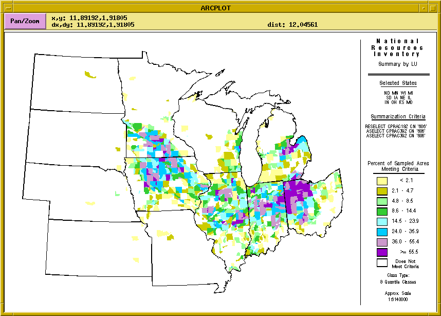
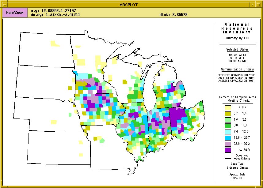
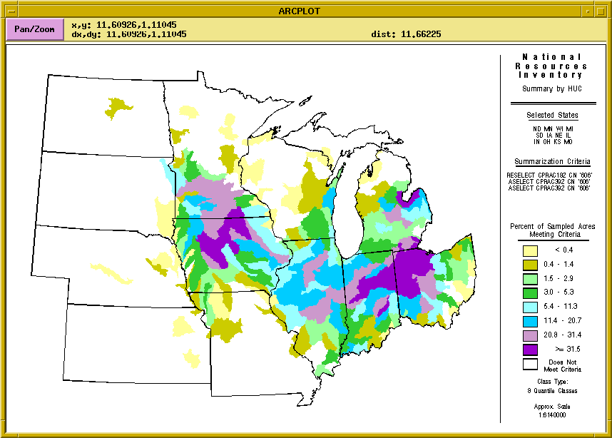
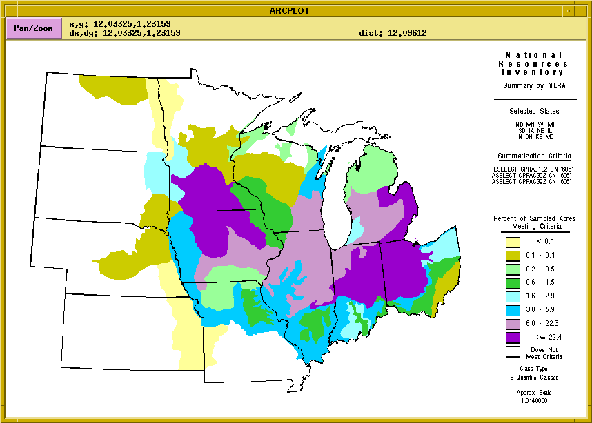
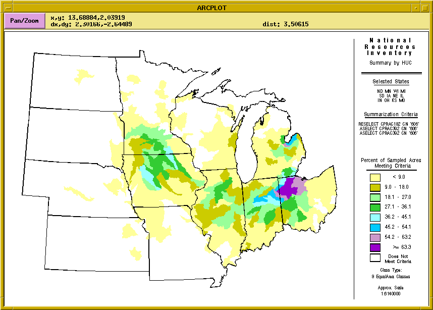
As an example of using the NRI Data Explorer, the following discussion investigates the use of subsurface tile drainage as an agricultural practice that may affect ground water quality.
Conservation Practice (CPRACn) is a discrete variable available for each survey year in the NRI, noting the presence of one of several conservation practices. This variable may have up to three values (CPRAC1, CPRAC2, CPRAC3) for each recorded sample. One value for CPRACn is 606 which represents a subsurface drain. Selecting for NRI points with CPRACn containing 606 in any of the three surveys would produce a subset of points representing areas where subsurface drainage was practiced.
As described previously, the display of the query results will depend on the characterization criteria specified by the user. Care must be taken to understand the ramifications of aggregation and characterization techniques that the Data Explorer provides. The following links display the results of the example query using the different spatial aggregation frames. In the map legends, note the change in the class ranges and the manner in which the map communicates the results.
Each of the four maps use a quantile classification scheme to display the results. The results appear dramatically different if the samples were aggregated by Watersheds (HUC) with an Equal Area classification scheme. The ability to readily modify aggregation, characterization, and classification methods provides the user with great flexibility in examining the NRI data base and, at the same time, requires thoughtful inspection of the results.
The NRI Data Explorer described in this paper is the framework upon which an analytical tool can be constructed. Work will continue initially to add the capability for more than five queries statements; the facility to allow combinations of variables using simple arithmetic operations (e.g. USLE estimate soil loss - USLE tolerance factor); and the capability of boolean operations based upon comparing variables (i.e. CROP87 NE CROP92).
Longer term research will move toward the goal of including integrating models that use complex calculations to derive results. The projects for which this tool is being developed have as objectives the assessment of ecological and natural resources as well as economic outputs at the regional and national scales. Consequently, the ultimate form the the NRI Data Explorer will include a means to estimate environmental or economic endpoints directly from NRI and related soil parameters.
Burkart, M.R., C.A. Onstad, and G.D. Bubenzer. 1990. Research on agrichemicals in water resources. Trans. Am. Geophys. Union 71:980-988.
Gianessi, L.P., and C.M. Puffer. 1990. Herbicide use in the United States, Qual. of the Environ. Div., Resources for the Future pub., Washington, DC. 490 p.
James, D. and M. Hewitt, 1992. To save a river: building a resource decision support system for the Blackfoot River drainage. Geo Info Systems 2(10):36-49.
Jenks, G.F. and F.C. Caspall. 1971. Error on choropleth maps: definition, measurement, reduction. Annals of the Assoc. of American Geographers, 61(2):217-244.
Oberle, S.L. and M.R. Burkart. 1994. Water resource implications of Midwest agroecosystems. J. Environ. Qual. 23:4-9.
Onstad, C.A., M.R. Burkart, and G.D. Bubenzer. 1991. Agricultural research to improve water quality. J. Soil Water Conserv. 46:184-188.
Puterski, R. 1993. Selecting class intervals for choropleth mapping. Proceedings of the Thirteenth Annual Esri Users Conference. Redlands, CA.
U.S. Department of Agriculture. 1991. Instructions for Collecting 1992 National Water Resources Inventory Sample Data. U.S. Department of Agriculture - Soil Conservation Service. U.S. Govt. Print. Office. Washington, D.C. 68 p.
U.S. Environmental Protection Agency. 1990. County level fertilizer sales data, computer disk. September 1990. Office of Policy Planning and Evaluation. U.S. Govt. Print. Office. Washington, DC.
Although the information in this document has been funded wholly or in part by the United States Environmental Protection Agency under contract 68-CO-OO5O to the Environmental Monitoring System Laboratory - Las Vegas, it has not been subjected to Agency review and therefore does not necessarily reflect the views of the Agency and no official endorsement should be inferred.