
On October 20, 1991 an uncontrollable wildfire, a firestorm, destroyed approximately 1,580 acres and destroyed over 2,700 structures near the Caldecott Tunnel within the cities of Oakland and Berkeley, California. Since that time, other firestorms in California have devastated thousands of acres and continue to destroy property in the urban/wildland interface. The question remains, how can we prevent these disasters? This study was undertaken to construct a spatial decision support system (SDSS) so that planners and decision makers could better manage and formulate policy that would help reduce the risk of a firestorm. This paper models and assesses the risk of firestorms in the East Bay hills and produces a spatial support system that could help manage and reduce the risk of future firestorms. A geographic Information System (GIS) is used as a framework for quantifying fire hazard in this heterogeneous landscape. Two models, one to assess the wildland fire hazard and the other to assess the urban/residential fire hazard, are integrated and embedded within the GIS to map both regional and neighborhood risk. Hazard assessment maps are generated which represent the results of quantitative multivariate analysis and clearly identify the hazardous neighborhoods. The system produced provides an ideal tool for managing and reducing the risk of a firestorm. It allows for future adjustment of one or all of the parameters as fire prevention policy and techniques are implemented and hazardous conditions are mitigated. This feature provides a mechanism for accounting and feedback allowing for the appraisal of the success of mitigation.
Fire is not a new phenomenon in California. The Mediterranean climate, the rugged topography, a shifting urban-wildland interface, and the practice of fire suppression in recent history have all collaborated to create the increased potential for catastrophic fires. In 1923, a fire much like the 1991 Oakland firestorm, claimed 584 homes, and over the past hundred years dozens of fires in the East Bay Hills have been documented. These fires continue to foretell of the potential hazards that exist in the urban-wildland interface. From 1920 to 1990 3,036 structures were lost to fire in the East Bay Hills. From 1990 to 1994 alone, the number of structures lost was 5,298. Fires will continue to start and burn in the East Bay Hills.
The immediate contemporary response to a fire is reactive in nature and one of emergency. The field of emergency response systems is rapidly expanding and Mother Nature is being given the credit for forcing this industry to grow up in a hurry. Geographic information systems (GIS) are now being planned and built to accommodate real time data which can be used to combat a disaster by: locating and monitoring its advance, allocating resources to stop it, and evacuating the public from its dangerous advance. The focus here has been goal directed, to stop the advancing disaster, rather than on trying to prevent or reduce the risk of disaster. A comprehensive fire response strategy must move toward the preemptive end of the spectrum and practice prevention. One of the best fire control strategies is to reduce and manage, on a long term basis, vegetation and structural conditions that fuel fire.
Natural hazards do not recognize land use differentiation, yet the cost and impact is often greatly affected by land use differentiation. Wild fires are often magnified by heterogeneous landscapes and land use, such as those found at the urban-wildland interface. It is critical that we map these conditions and develop predictive models that are embedded a GIS to prevent firestorms through better management and decision making.
The Study Site
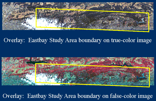
The rectangle in Figure 1, delineates the study site in the East Bay and locates the 1991 Oakland Firestorm. Figure 2 is a 7 m2 true color composite of bands 1,2 and 3 from the NS001 scanner aboard a NASA low altitude aircraft. The area of the Oakland Firestorm, delineated in Figure 1, can be clearly seen in the image. The study site is considered the nexus of the urban residential and wildland landscapes in the East Bay and provides an excellent dataset for this type of study. The site is 54.3 square miles and forms a rectangle which follows the regional ridge line of the East Bay Hills.
Objectives
The main objective of this paper is to provide an ancillary approach to what is now commonly referred to as emergency response. Like the medical profession, rather than wait until the patient is critical and an emergency is declared, the approach presented here offers a preventative schema based on reducing risk of fire in an heterogeneous landscape. The approach integrates multisource spatial data with field observations and produces a GIS within which risk modeling is performed. Two models, one to assess the wildland fire hazard, and the other to assess the urban/residential fire hazard, are implemented within a GIS to map risk. This modeling endeavour yields an efficient spatial decision support system (see Fedra and Reitsma, 1990) which now also serves fire hazard detection and management efforts in the East Bay Hills. The results of this effort provide the information and mechanism necessary for decision- makers to better mitigate against future firestorms.
The Potential for Fire
Three conditions: weather, topography and fuel type, effect the intensity of fire and are well documented in the literature (McArthur 1966,1967, Rothermel and Rinehart 1983, Beer 1990). In the East Bay Hills two of these conditions, weather and topography, are extreme, unchangeable and add to the risk of a fire storm. However, fuel type, can be modified and managed to reduce risk. In this study, fuels consist of vegetation in the wildlands and both vegetation and built structures in the urban-wildland nexus. Major characteristics that determine how fuel types will burn are in two data dictionaries, one for wildlands (Table 1) and one for residential (Table 2).
TABLE 1: Wildland Fire Hazard Data Dictionary
| Vegetation Type | ||
|---|---|---|
| No Vegetation | Alameda Mazanita | Eucalyptus - 5 to 20 yr |
| Serpentine Grassland | Successional Scrub | Eucalyptus -1 to 5 yr |
| Grassland | Mixed Hardwood Woodland | Eucalyptus - >20 yr mature |
| Oak Savannah | Mixed Hardwood Forests | Acacia |
| Wet North coastal scrub | Riparian Forests | Cypress |
| Dry North coastal scrub | Pine Forest Plantation | Mature Pine/Eucalyptus Mix |
| French Broom | Pine Forest Mature | Treated Forest with slash |
| Diablan Sage Scrub | Redwood/Douglas Fir Forests | Other Vegetation |
| North mixed charparral |
| Fuel Model Categories (for the BEHAVE Model) | |
|---|---|
| No Fuel Model | Southern Rough |
| Short Grass | Closed Timber Litter |
| Timber/Grass | Hardwood Litter |
| Tall Grass | Timber Litter/Understory |
| Charparral | Light Slash |
| Brush | Medium Slash |
| Dormant Brush | Heavy Slash |
| Heavy Slash | |
| Other - not labeled (none in this category) |
| Development Stage | Crown Potential | Tree Height |
|---|---|---|
| None Development Stage | None -- default | None -- default |
| Low Development Stage | Low | Short 20-30 ft |
| Moderate Development Stage | Moderate | Early Mature 30-50 ft |
| High Development Stage | High | Mature 50-70 ft |
| Extreme Development Stage | Extreme | Dominant 70-90 ft |
| Overmature > 90 ft |
Weather conditions play a critical role in the risk of fire and the potential damage a fire can do once initiated. Temperature, wind velocity and relative humidity impact fuel moisture, ignition potential, flame length and rate of spread. Warm, dry easterly Diablo winds, regularly reach velocities in excess of 20 miles per hour, bring temperatures in excess of 80 degrees Fahrenheit and drop the humidity to less than 20 percent. Diablo winds occur on average 4 to 6 days a year usually in late September or early October and are the ideal weather conditions for a firestorm.
Two empirically based models exist that have been extensively applied (Beer 1990). The McArthur meters (McArthur 1966, 1967) is widely used in eastern Australia and the Rothermel model (Rothermel, 1972 ) is used in the United States as part of the US Forest Service's BEHAVE system of fire prediction (Burgan and Rothermel 1984). Recent experiments show the Rothermel model needs further refinement in the parameterization of mixed fuels to predict accurate intensity values (Catchpole et al. 1993). However, at this time it is the most appropriate model to predict the behaviour of fire in the wildland area in the East Bay Hills.
To assess and model fire hazard in the residential region of the study site, the knowledge of fire experts was assembled and a set of rules formulated to select criteria for fuel assessment and fire risk prediction. Observations were made and documented into two classes, vegetation type and building material type. Table 2 represents the data dictionary for the residential fire hazard assessment model (RFHAM).
TABLE 2: Residential Neighborhood Fire Hazard Data Dictionary
| Fuel Characteristics | Measurement | Low | Moderate | High | Extreme | |
|---|---|---|---|---|---|---|
| Structural Fuels: | combustible roof materials | % structures with wood roofs | None | <20% | 20-50% | >50% |
| Siding, decking and fencing | %Structures with combustible siding, decking or fencing | None visible | <20% | 20-50% | >50% | |
| Vegetation Fuels: | Surface Fuel Density | %Surface area supporting combusitible surface fuels | <20% | 20-50% | 50-70% | >70% |
| Aerial Fuel Density | %Surface area covered by tree canopy | 0-10% | 10-30% | 30-70% | >70% | |
| Vertical Continuity | Presence of ladder fuels and crown fires potential | None | Isolated ladder fuels, Individual trees to crown | Widespread ladder fuels, Stand-wide crown fire expected | ||
| Tree Height | Tree height | Short=<50 ft | Intermediate=50-90 ft | Tall =>90 ft | ||
| Flammability | Overall flammability of fuels | Irrigated grass, Ornamental hardwoods | Cured grasses, Native hardwoods, Cultivated landscapes | Pyrophytes (Juniper, pine, eucalyptus, etc.) | ||
| Fuel Clearance | Clearance distance of combustible material from structure | Poor =<10ft | Moderate =10-30ft | Good =30-100ft | Excellent =>10ft | |
| Risk Value Assignment | 1 | 2 | 3 | 4 |
In the RFHAM a relative weighting scheme was applied to the individual factors described in Table 2. The weights (Table 3) were derived from a survey of fire experts, many of whom had considerable experience fighting fires in the East Bay Hills. This knowledge-based model produces a residential fire hazard assessment framework valuable for planning and managing to prevent firestorms.
TABLE 3: Relative Weighting of Factors to Assess Urban Wildland Intermix Haza rd
| Vegetation Type | ||
|---|---|---|
| Fuel Characteristics | Weighting Factor | |
| Structural Fuels | Combustible Roof Materials | 75% |
| Siding, decking & fencing | 25% | |
| Vegetation Fuels | Surface Fuel Density | 25% |
| Aerial Fuel Density | 10% | |
| Vertical Continuity | 20% | |
| Tree Height | 10% | |
| Flammability | 10% | |
| Fuel Clearance | 25% |
The Data Base
Some of the data already existed as ancillary data (1) and served the purposes of this study. Of the ancillary data, some existed in digital form and some in paper form. Other data were gathered through field work which were either transferred directly to the data base from a field computer or later digitized in a computer laboratory.
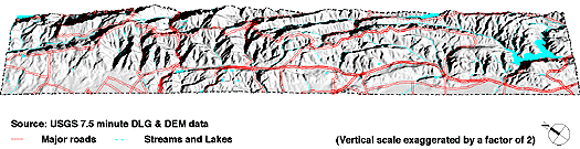
Digital Line Graphs (DLG), hypsography, hydrography and a Digital Elevation Model (DEM) are combined to construct a base map and a three dimensional surface model to satisfy the topographical needs of the wildland modeling. (See Figure 3)
The wildland vegetation layer was delineated using aerial photographs and images obtained from a NASA low altitude data gathering flight in August of 1993. Five acres was determined to be the minimum patch size to be practically managed and mapped in the wildland region. Homogeneous patches of vegetation were registered, digitized and then visited in the field for identification using a Trimble Navigation Differential Global Positioning System (DGPS). (See Huxhold 1991:205).
The fire hazard classification scheme applied in the wildlands region was not appropriate for the residential region. Observed patches of vegetation in the wildlands, where natural processes of succession and invasion apply, tended to be homogenous. In contrast, urban-wildland nexus areas, which are predominantly occupied and dominated by humans, are more heterogeneous with a great variety of structural as well as vegetation conditions. The conditions observed were not based on an individual property or structure, but on the characteristics of a neighbourhood. The observer evaluated groups of structures to establish the sample neighbourhood of similar attributes.
The DGPS units made it possible to automate the residential spatial point sampling scheme by entering eight different attribute observations (Table 2) at each sampling location. Observations were taken at regular intervals (approximately every block) and adjusted where changes occurred in any one or all of the eight sampled attributes. Over 3200 observations were made by the same observer to eliminate variation in interpretation (2).
Fire Modeling Results
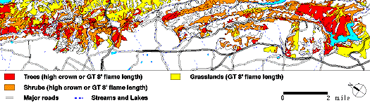
The BEHAVE model is applied assuming extreme Diablo wind conditions prone to firestorms. The topographic gradients are averaged for each polygon and the results are further classified into categories with 10% ranges. Many extreme slopes exist within the study site and are classified in an upper range slope category of >40% slope. The final parameter, the physical properties of vegetation, are assembled from a compiled set of conditions: vegetation type, fuel model, and development stage (See Table 1).
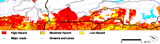
The results of this modeling effort classify each vegetation polygon for flame length (ft), rate of spread (ft/min), heat released per-unit-area (BTUs/square ft), and crowning potential where crowning potential refers to the probability of fire reaching the crown of an entire stand of trees or shrubs. From these results we generate hazard assessment maps with patterns of polygons which indicate spatially cumulative risk. (See Figure 4) The results of the BEHAVE model show that approximately 10,500 acres or over half of the wildlands in the study area have the ability to fuel and produce a firestorm in Diablo wind conditions.
The RFHAM is applied separately for the two types of fire hazard: i) vegetation and its distribution with respect to structures, and ii) structural materials and building design. Expert knowledge from local fire fighters helped select the components to be measured and also rated the components with a risk value (1 to 4) to the observed conditions for each type of fuel characteristic in Table 2.
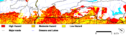
To effectively visualize the results of the model, the output is synthesized into three categories: high, moderate and low hazard for both structural and vegetation conditions. Figure 5 maps the residential fire hazard for structural conditions where 5,664 acres or 35% of the residential region is in the high hazard category for structural fuels and would likely contribute to the development of a firestorm in Diablo wind conditions. Figure 6 maps the RFHAM results for vegetation fuels and shows 7,679 acres or 47% of the residential region labeled as high hazard. This high hazard acreage is almost five times the area burned by the Oakland Firestorm and would potentially fuel another firestorm given the right weather conditions.
Conclusions
The complexity of the landscape in the East Bay Hills dictates a SDSS to predict and manage fire risk. The method developed here integrates multisource spatial data with field observations and produces a GIS wherein risk modeling is undertaken. The results show that almost half of the study site can be classified as high risk and could experience conditions similar to those that occurred during the Oakland Firestorm.
The results of this study provide planners and policy makers with a spatial decision support system that maps where and how great the current fire risks are. With this tool, effective policy and management techniques can be implemented to mitigate and reduce the risk of firestorms.
Further calibration is needed to improve existing fire modeling and new models dedicated to urban- wildland conditions need to be developed. Management models need to include information about the existing 'response infrastructure' and the capability of the community to respond in an emergency. Predictive models which measure rates of change in fuels need to be built in order to track and manage mitigation efforts now being prescribed. Until such research is conducted, this study provides an effective method of predicting risk of fire in the East Bay Hills.
(1) These are data that have been gathered by both the government (for example the United States Geological Survey - Digital Line Graphs (USGS-DLG), the United States Geological Survey - Digital Elevation Models (USGS-DEM), the Soil Conservation Survey (SCS) - Soil Series, and other entities such as the East Bay Municipal Utility District (EBMUD) - water distribution utility data, for purposes other than this study. (2) Using the same observer would render any bias a constant which could be adjust in the model.
Acknowledgments
This project evolved from several valuable discussions with Jerry Kent (East Bay Regional Parks District) and Tony Acosta (City of Oakland Parks Department) both from the Vegetation Management Consortium. Greg Biging led the remote sensing team and Robert E. Martin led the fuels and fire behaviour team. Other valuable contributions were made by a number of graduate and undergraduate students who worked in the field and in the AEGIS computer laboratory. These include: Douglas Allen, Maria Cacho, Randy Craig, Matthias Dobbertin, Giselle Downard, Sigal Eylon, Alan Johns, Mintai Kim, Randy Lien, Chris Morrison, Carrie Salazar, David Sapsis, and Gordon Ye.
This project was supported by the East Bay Hills Vegetation Management Consortium, the Federal Emergency Management Agency (FEMA), The University of California, Berkeley, Trimble Navigation, Inc., the National Aeronautics and Space Administration (NASA), the US Soil Conservation Service (SCS), the City of Oakland, and the East Bay Regional Parks District (EBRPD). In addition, some utility data was made available from the East Bay Municipal Utility District (EBMUD).
References
Andrews, P.L. and R.C. Rothermel, 1982. Charts for interpreting wildland fire behaviour characteristics. U.S. Department of Agriculture, Forest Service, General Technical Report INT-131.Intermountain Forest and Range Experiment Station, Ogden, Utah.
Aronoff, S. 1990. Geographic Information Systems: A Management Perspective. WDL Publications, Ottawa, Canada.
Beer, T. 1990. "The Australian National Bushfire Model Project", Mathematical Computer Modeling, Vol. 13, No. 12, pp.49-56.
Burgan, R.E., R.C. Rothermel, 1984. BEHAVE: Fire behavior prediction and fuel modeling - Fuel subsystem. U.S. Department of Agriculture, Forest Service, General Technical Report INT-167. Intermountain Forest and Range Experiment Station, Ogden, Utah.
Burrough, P.A. 1986. Principles of Geographic Information Systems for Land Resources Assessment. Clarendon Press, Oxford.
Catchpole, E.A., W.R. Catchpole, R.C. Rothermel, 1993. "Fire Behavior Experiments in Mixed Fuel Complexes", International Journal of Wildland Fire, Vol. 3, No.1, pp.45-57.
Clarke, K.C. 1990. Analytical and Computer Cartography. Prentice-Hall, Englewood Cliffs, New Jersey.
Fedra, K. and R.F. Reitsma, 1990. "Decision Support and Geographic Information Systems." In Scholten, H.J. and J.C.H. Stillwell (eds.), Geographic Information Systems for Urban and Regional Planning. Kluwer Academic Publishers, The Netherlands, pp.177-188.
Getis, A. and B. Boots, 1978. Models of Spatial Processes: An Approach to the Study of Point, Line and Area Patterns. Cambridge University Press, New York.
Goodchild, M.F., B.O. Parks and L.T. Steyaret, 1993. Environmental Modeling with GIS. Oxford University Press, New York.
Huxhold, W.E. 1991. An Introduction to Urban geographic Information Systems. Oxford University Press, New York.
Kessel, S.R. 1990. "An Australian geographical information and modeling system for natural area management," International Journal of Geographical Information Systems, Vol. 4, No. 3, pp.333-362.
Maguire, D.J., M.F. Goodchild and D.W. Rhind (eds.) 1991. Geographic Information Systems: Principles and Applications. Harlow, Essex, England.
McArthur, A.G. 1966. Weather and grassland fire modeling. Commonwealth of Australia, Forest and Timber Bureau, Canberra, Leaflet No. 100.
McArthur, A.G. 1967. Fire modeling in eucalypt forests. Commonwealth of Australia, Forest and Timber Bureau, Canberra, Leaflet No. 107.
McHarg, I. 1969. Design with Nature. Doubleday, New York.
McRae, R.H.D. 1990. "Use of Digital Terrain Data for Calculating Fire Rates of Spread with the Preplan Computer System". In Mathematical Computer Modeling, Vol. 13, No. 12, pp.37-48.
Peucker, T.K., Fowler, R.J., Little, J.J., and Mark, D.M. 1978. "The triangulated Irregular Network." Proceedings, Auto Carto III, Falls Church, VA: American Congress on Surveying and Mapping, pp.516-540.
Radke, J.D. 1988. "On the shape of a set of points". In Computational Morphology, G.T. Toussaint, (ed.) pp.105-136.
Rejeski, D. 1993. " and Risk: A Three-Culture Problem." In Goodchild, M.F., B.O. Parks and L.T. Steyaret (eds.), Environmental Modeling with GIS. Oxford University Press, New York, pp.318-331.
Rothermel, R.C. 1972. A mathematical model for predicting fire spread in wildland fuels. U.S. Department of Agriculture, Forest Service, Research Paper INT-115. Intermountain Forest and Range Experiment Station, Ogden, Utah.
Rothermel, R.C. and G.C. Rinehart, 1983. Field procedures for verification and adjustment of fire predictions. U.S. Department of Agriculture, General Technical Report INT-142. Intermountain Forest and Range Experiment Station, Ogden, Utah.
Star, J.L. and J.E. Estes, 1990. Geographic Information Systems: An Introduction. Prentice-Hall, Englewood Cliffs, New Jersey.
Stocks, B.J., B.D. Lawson, M.E. Alexander, C.E. Van Wagner, R.S. McAlpine, T.J. Lynham, and D.E. Dube, 1989. "The Canadian Forest Danger Rating System: and overview" in Forestry Chronicle, Vol. 65, pp.450-457.
Van Wilgen, B.W., D.C. le Maitre, and F.J. Kruger, 1985. "Fire modeling in South African fynbos (macchia) vegetation and predictions from Rothermel's fire model." Journal of Applied Ecology, Vol. 22, pp.207-216.
Dr. John Radke
Departments of Landscape Architecture and City and Regional Planning
College of Environmental Design
University of California, Berkeley
Berkeley, CA 94720
Telephone: (510-643-5995)
Fax: (510-254-0955)
E-mail: ratt@ced.berkeley.edu