Henrik Refstrup Soerensen, Boerge Storm, Danish Hydraulic Institute
Frank Deckers, Frank Wardenburg, TNO
The Danubian Lowland Information System (DLIS) is an information system based on and integration of ArcInfo GIS with INFORMIX database and DHI's mathematical modelling systems MIKE SHE, MIKE11 and MIKE 21. The DLIS is one of the tools which are being used by Slovak, Dutch and Danish scientist in their investigations of the complex environmental problems of the Danubian Lowland located between Bratislava and Komarno in the Slovak Republic. The DLIS has been established as part of the project "Danubian Lowland - Ground Water Model", which is undertaken by a Danish-Dutch consortium comprising six organisations headed by DHI. The project is sponsored under the EU PHARE programme and focuses on a variety of environmental issues related to:
-Ground Water Flow and Ground Water Chemistry
-River and Reservoir Hydrodynamics
-Water Quality and Sediment Transport in Rivers and Reservoirs
-Agricultural Production and Nitrate Leaching, and
-Aquatic and Floodplain Ecology
The scientific basis of the project is provided by an integration of DHI's modelling systems MIKE11, MIKE21 and MIKE SHE, the core of which is MIKE SHE.
The model area comprises about 3,500 km2 of the Danubian Lowland between Bratislava and Komarno. Within this area, the Gabcikovo hydropower scheme was finalised in October 1992, and the related reservoir and various hydraulic structures have major impacts on the hydrological regime and the ecosystem in the region. The Gabcikovo hydropower scheme causes the most important of the man-induced impacts, and the immediate project objective is to develop an integrated modelling system that can be used as the technical/scientific basis for future management decisions.
Such a multidisciplinary project involves large amounts of different data to be used for model setup, calibration and validation, which together with the requirements in terms of presentation and interpretation of results, calls for efficient GIS functions. The DLIS has been developed to meet these requirements. The technical approach of the project as well as the DLIS in particular are described in (Ref 1).
The European Hydrological System - SHE was developed in a joint effort by Institute of Hydrology (UK), SOGREAH (France) and Danish Hydraulic Institute. It is a deterministic, fully-distributed and physically- based modelling system for describing the major flow processes of the entire land phase of the hydrological cycle. Since 1987 the SHE has been further developed independently by the three respective organizations which now are University of Newcastle (UK), Laboratoire d'Hydraulique de France and DHI. DHI's version of the SHE, known as the MIKE SHE, represents significant new developments with respect to user interface, computational efficiency and process descriptions. A description of MIKE SHE is given in (Ref. 2).
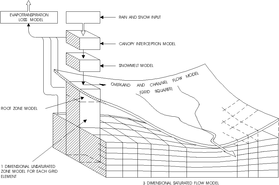
MIKE SHE solves the partial differential equations for the processes of overland and channel flow, unsaturated and saturated subsurface flow. The model is completed by a description of the processes of snow melt, interception and evapotranspiration. The flow equations are solved numerically using finite difference methods.
In the horizontal plane the catchment is discretized in a network of grid squares. The river system is assumed to run along the boundaries of these. Within each square the soil profile is described in a number of nodes, which above the groundwater table may become partly saturated. Lateral subsurface flow is only considered in the saturated part of the profile. Fig. 1 illustrates the structure of the MIKE SHE.
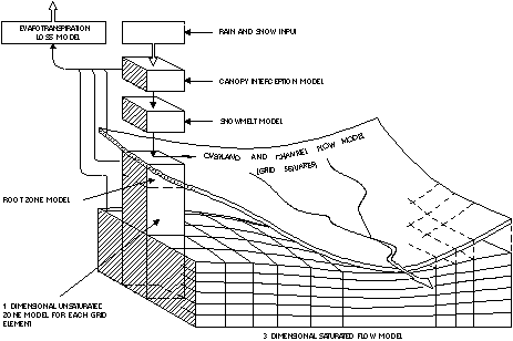
Fig. 1. Schematic presentation of the MIKE SHE. - Unscaled image
The spatial and temporal variations in the catchment characteristics and meteorological input are provided in a series of two-dimensional matrices of grid square codes. To each code is further attached a number of attributes describing either parametric data or input data.
The distributed description in the MIKE SHE allows the user to include and test against spatially varying data. MIKE SHE is a multi output model which besides discharge in any river link also produces information about e.g. water table elevations, soil moisture contents, infiltration rates, evapotranspiration, etc. in each grid square.
MIKE 11 is a comprehensive, one-dimensional modelling system for the simulation of flows, sediment transport and water quality in estuaries, rivers, irrigation systems and other water bodies. It is a 4th generation modelling package designed for micro-computers with DOS or UNIX operating systems and provides the user with an effecient interactive menu and graphical support system with logical and systematic layouts and sequencing in the menus. The package was introduced in 1989 and today the number of installations world-wide exceeds 300.
The hydrodynamic module of MIKE 11 is based on the complete partial differential equations of open channel flow (Saint Venant). The equations are solved by implicit, finite difference techniques. The formulations can be applied to branched and looped networks and quasi two-dimensional flow simulations on floodplains. A description of MIKE 11 is given in (Ref. 3)
MIKE 11 operates on the basis of information about the river and the floodplain topography, including man- made hydraulic structures such as embankments, weirs, gates, dredging schemes and flood retention basins. The hydrodynamic module forms the basis for morphological and water quality studies by means of add-on modules.
MIKE21 is a comprehensive modelling system for 2-dimensional free surface flows applicable to studies of lakes, reservoirs, estuaries, bays, coastal areas and seas where stratification can be neglected. MIKE21 solves the vertically integrated equations of continuity and conservation of momentum in two horizontal dimensions. Like MIKE11, MIKE21 has a modular structure where water quality modules and sediment transport modules are available as add-on modules to the MIKE21 hydrodynamic module.
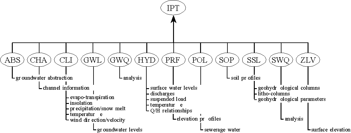
The information point (IPT) is an important concept of the data model. Information points are locations (x,y and (optionally z)) where a certain kind of information have been recorded. Different kind of data may be stored at and IPT. Typical data are recorded timeseries of a certain feature, or just a single value, for instance surface elevation. 12 different IPT's have been included in the DLIS:
ABS - ground water abstraction points
CHA - channel information points
CLI - climatology information points
GWL - ground water level information points
GWQ - ground water quality information points
HYD - hydrology information points
POL - point pollution source information points
PRF - profile information points
SOP - soil profile information points
SSL - subsoil log information points
SWQ - surface water quality information points
ZLV - surface level information points
Depending on its type, various measurements or observations may be recorded at an IPT. The data that may be connected to a certain IPT are illustrated in Figure 2.
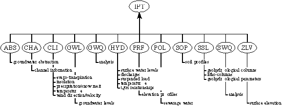
Fig. 2 Information points and data types - Unscaled image
Some additional information may also be related to an IPT. For instance, exact location of the IPT, unique identification, name and address of owning organisation, device that has been used for the measurements etc.
The DLIS uses standard ArcInfo layer oriented geographic data models comprising coverage, grid, tin, image, CAD drawing and lattice for representing geographic information. The term geographic data set refers in the following to any kind of geographic data structure represented in any of the ArcInfo data models.
In DLIS geo data sets have been classified into 7 groups (themes) as follows:
- general data (dls)
- ground water (grw)
- surface water (sfw)
- subsoil (ssl)
- thematical data (thm)
- geohydrological model (glm)
- background data (bck)
Figure 3 gives a schematic overview of the geographic data sets that, at present, are implemented in DLIS.
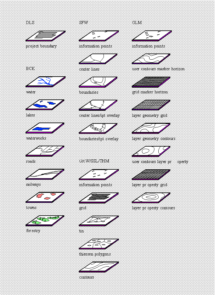
Fig. 3 Geo data sets implemented in the DLIS
Typically a geographic data set is generated based on data stored in IPT's in the Informix data base as illustrated in Figure 4. This could for instance be interpolation of a surface topographical map or generation of an average ground water table over a certain periode of time.
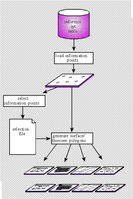
Fig. 4 Dataflow when generating geographic data sets
The selection of the IPT's to be used for a surface generation can be controlled by specifying a number of selection criteria. Such criteria may be expressed in terms of time and space. Typical selection criterias could be - 1. select all IPT's within a certain area and, 2. select all data stored at the selected IPT's within a certain periode of time. Also criterias as depth interval or data interval may be applied enabling a flexible and efficient selection of the data to be processed. Selections are saved in a selection file in ArcPlot format.
The DLIS also provides facilities for storing and presenting information on surface water bodies such as rivers, canals, reservoirs etc. The DLIS contains information on spatial (channel geometry) and non spatial properties (f.eg. water quality properties). Surface water bodies are defined as a combination of IPT's where data are stored (measured water levels, river cross-sections etc.) and channel centerlines and channel segment boundaries.
A number of standard background data (bck) have been stored in the DLIS. These data mainly comprises infrastructural information as roads, railways, towns, water works, water ways etc.
In order to present and study simulation results of the hydrological modelling in the ArcInfo environment a link between MIKE SHE, MIKE11, MIKE21 and DLIS has been developed. This link enables export of ArcInfo spatial structures like tins, grids and contours to fileformats supported by MIKE SHE and MIKE21. In addition procedures have been made that allows for import of MIKE SHE and MIKE21 results (MIKE SHE 2D grid file) in DLIS where they can be displayed together with any geo-data set.
DLIS also enables import/export of time-series data in MIKE SHE, MIKE11 and MIKE21 file formats. This may be input data as precipitation, temperature etc. or data used for model calibration as measured ground water levels or river runoff.
DLIS also includes facilities for interactive selection of river cross-sections (IPT's) and subsequent dump of cross-sections to a file format supported by MIKE11.
The DLIS has mainly been used in the early phase of a model setup, where data have been provided in proper file formats and in the last phase of the modelling for presentation of results. However, DLIS is also a useful tool during model calibration. When establishing a model setup for a complex physically based hydrological model like MIKE SHE, it is always necessary to make a conceptualization or, in other words, a simplification of the real world. In this process you focus on the most important factors and takes them into account in the mathematical model. However, when calibrating such a complex 3D hydrological model there are often certain areas, or just single model grids, where large discrepancies between model results and measurements are observed. Often these can be explained by local factors that does not affect the overall model calibration. Such a local factor could for instance be a small canal or a ground water abstraction that is not included in the model, therefore creating a discrepancy between the model results and the measured data. Discrepancies could of-course also be caused by a model setup that is simply to coarse or by an insufficient or wrong model calibration or simply by errors in the measured data. A working process where possible reasons for such discrepancies are identified is very often a part of a calibration procedure and, in particular, if complex modelling systems and large amounts of data are involved it may be a very time consuming process. A GIS/Database system like the DLIS forms a very efficient tool in such a "problem identification process".
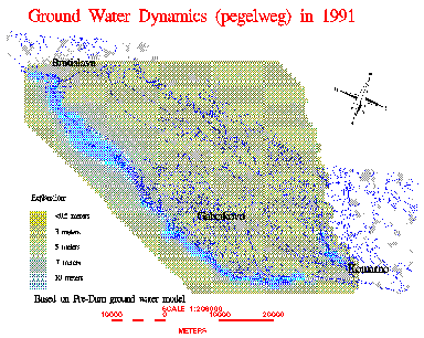
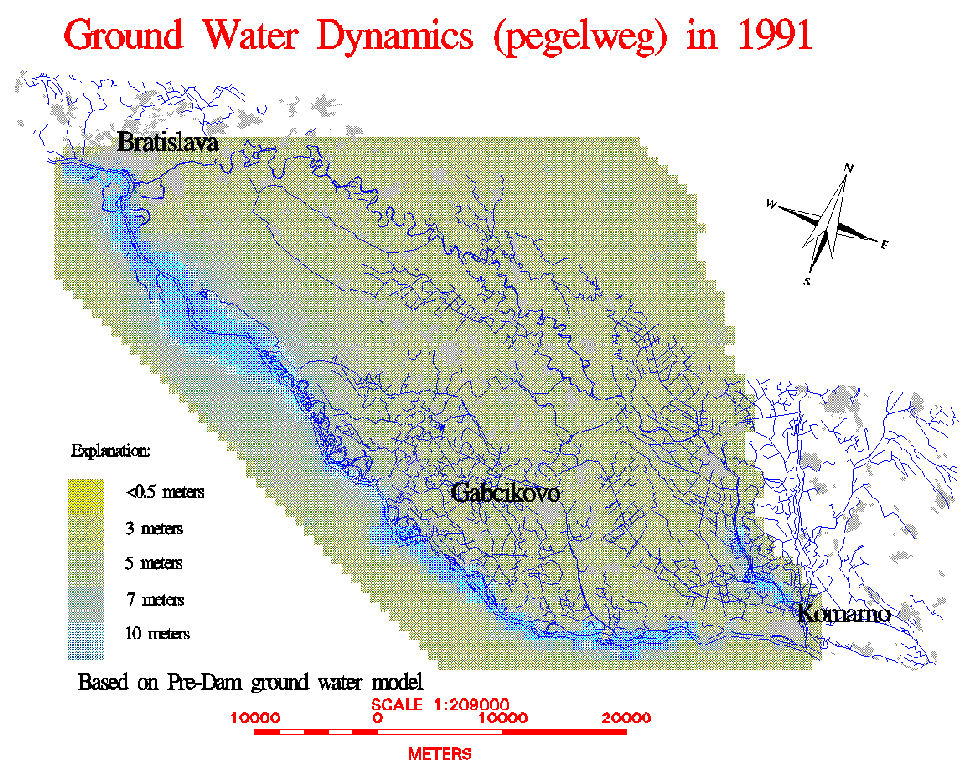
Fig. 5 MIKE SHE results in DLIS - Unscaled image
An example of MIKE SHE results presented as a grid in DLIS is shown in Figure 5. The figure illustrates the impacts of the Danube river on the ground water dynamics in the project area. The dynamics of the ground water table are characterized by the annual sum of ground water level fluctuations on a weekly basis (Pegelweg). The surface water dynamics of the Danube are of major importance to the ground water dynamics and the ground water table fluctuations at locations near the Danube show a high correlation with the Danube water level fluctuations. The evapotranspiration/precipitation relation generally plays a minor role in the ground water dynamics. Ground Water dynamics are important in relation to ground water chemistry and flood plain ecology.
The DLIS has been developed as part of the PHARE project Danubian Lowland - Ground Water Model and integrates ArcInfo GIS with the INFORMIX data base and the applied hydrological and hydraulic modelling systems. Technology transfer is an important aspect of the PHARE project, and Slovak scientists have received extensive training in INFORMIX, ArcInfo and in the DLIS itself. The DLIS has been developed into a menu based, rather user friendly, environment, but still the flexible and open structure of the DLIS allows Slovak scientists to further develop the DLIS, in order to meet any future needs.
During the execution of the PHARE project the DLIS has played an important role in maintaining and processing the huge amount of data that have been used for the modelling activities. In addition the ArcInfo GIS component of the DLIS has been widely used for studying and presentation of input data as well as model results.
1. Slovak Ministry of the Environment, Commission of the European Communities, Danish Hydraulic Institute.,"Danubian Lowland - Ground Water Model", Interim Report, January 1995.
2. DHI, "MIKE SHE Water Movement Short Description". Danish Hydraulic Institute, 1993.
3. DHI, "MIKE 11 Short Description". Danish Hydraulic Institute, 1993.
4. DHI, "MIKE 21 Short Description". Danish Hydraulic Institute, 1993.
Boerge Storm
Senior Hydrologist, Water Resources Division
Danish Hydraulic Institute
Agern Alle, DK-2970 Horsholm
Denmark
Phone: +45 45 76 95 55
Fax : +45 45 76 25 67
Frank Deckers
Software Engineer
TNO, Institute of Applied Geoscience
Schoemakerstraat 97
P.O. Box 6012
2600 JA Delft
The Netherlands
Phone: +31 15 69 69 00
Fax : +31 15 56 48 00
Frank Wardenburg
Software Engineer
TNO, Institute of Applied Geoscience
Schoemakerstraat 97
P.O. Box 6012
2600 JA Delft
The Netherlands
Phone: +31 15 69 69 00
Fax : +31 15 56 48 00