Kari Mikkonen, Antti Rainio
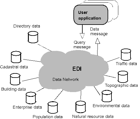
As a benefit of the service users do not need to copy existing databases and update copies. Instead, end user applications send electronic orders i.e. query messages through a data network for any piece of data. Requested data is immediately sent as a response message to a user application.
A database becomes a part of the EDI based geographic information
service when the server interface is implemented. The target is to
include all important geographic data resources in the service. This
means perhaps a hundred of databases from several organisations at the
state or local level.
Figure 1. EDI based geographic information service. All geographic data resources will be available for end user applications through EDI based information service. The service interface has already been implemented for the most important national databases covering data about real estates, buildings, persons, roads, environment quality, etc. (enterprises, climate, etc. are under preparation).
The EDI based geographic information service is an open client/server concept which is based on international EDI standards, especially EDIFACT (ISO 9735). It is application-to-application data interchange where the server systems of geographic data suppliers are serving the client applications of end users. Both ends of the interchange are supported by EDI software including an EDI translator. Even if the interchange is batch processing the response can be sent in real time. The orders are handled immediately or with delay i.e. 'just-on-time' (Rainio, Ahonen 1994).
The implementation of a server system to the Finnish road database has been described in detail by Marko Häkkinen (Häkkinen 1995).
Users benefit because the EDI based information service makes the data resources available to them whatever tools and software packages they prefer. Users do not need to learn different user interfaces because data can be taken into their own, familiar applications. The service can be implemented e.g. based on an existing export/import interface of a GIS software package. Users do not need to worry about connecting to server computers as their applications take care of the communication with the service system (Rainio, Ahonen).
SAMPO is an Avenue application on top of ArcView. Other components of
the system are data specific query forms built with Visual Basic, the
DLL-package G-EDIS (by Land Survey) for handling the conversions from
and to EDIFACT messages, a DLL package of FTP (TCP/IP) data
communication routines and suitable digital map data for spatial
reference.
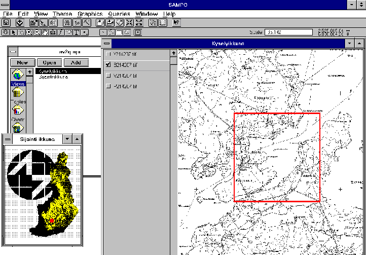
With SAMPO the user builds the query in two phases. He first defines the
spatial criteria by digitizing a shape on top of the chosen reference
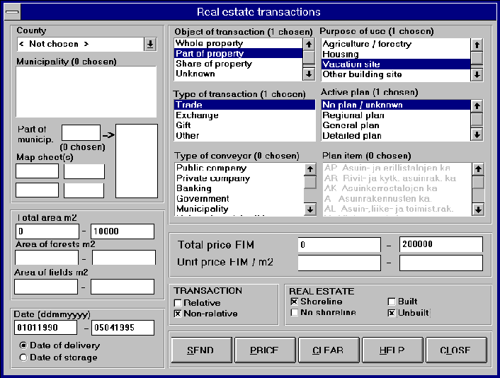
map in a view document. Then he gives the attribute criteria by filling
a query form that is specific for the queried database. The given
criteria are converted to an EDIFACT query message which is sent
(through Land Survey’s Service Center) to the data supplier's database
server. That server handles the order and sends back the response data
in EDIFACT syntax. SAMPO (the G-EDIS part) converts the data into an
ArcView shape file and presents it as a new theme on a view document.
The reference map on top of which the user builds the spatial query and presents the results can be any theme or combination of themes. Most commonly used data is the BasicCD data -- the scanned and georeferenced 1:20.000 base maps that are packaged on CD-ROM -- one CD for each whole county (Häkkinen 1994).
The query form displays all the attribute fields that can be used for selecting data from that particular database. Besides the data specific fields each form has five standard buttons. Pressing SEND converts the defined conditions to EDIFACT message and launches the electronic data order. PRICE button can be used to ask how much it will cost to perform a query with the given conditions. The price query is also sent to the database server but instead of actual data the server returns a price estimate based on how many data units fulfill the conditions. CLEAR button is used to reset all fields to empty or default values. Pressing HELP button opens a Windows Help page that displays information of the queried database. CLOSE button is used to exit the form.
Today SAMPO release 1.0 queries the following national databases:
These data bases cover fully the respective data of whole Finland except the boundaries data base that contains 70% of the real estate boundaries. Adding new data sets/new data base connections is trivial and requires little work. When the data supplier has established a new service and designed the data massage the service is easily adopted. No changes are needed in the program code, only definition files for EDI translations and a new data specific query form are required. More database connections will be available in SAMPO release 2 in the Fall 1995 when several new database servers to new databases have been established. The new databases will include e.g. business locations, cencus grid, climate data, road data, environmental data sets, geological data, ground water data, etc.
SAMPO is a commercial product. In its standard package it is bundled together with ArcView and a BasicCD disk that contains the scanned and georeferenced base maps of a chosen county. SAMPO can be also easily tailored or combined with other functionality to meet the needs of specific application areas, e.g. facilities management, municipal planning, marketing, banking, construction projects, site location etc.
Häkkinen, M. (1995), Paving the Information Superhighway - the National Road Database Case in Finland, Esri User Conference 1995, Proceedings
Häkkinen, M. (1994), Producing BasicCDs - the Raster Basic Map of Finland, Esri User Conference 1994, Proceedings
Kalevala - the Finnish National Epos
National Land Survey of Finland: Technical Standardisation of Geographic Information Services.