A. To present the geographic information exactly in conformance with the ArcInfo database.
B. To present a meaningful and readable cartographic product.
C. To present the DTP in response to a set of queries. A generic mechanism is provided for building new queries, with tools which can be used by the end user.
This paper describes the methods to develop a DTP in our GIS project, using Arc-Edit, Arc-Plot and Oracle tools. The DTP is a result of a specific query which is updated by the end-user. The product has been updated in each of the six desired DTP scales. The updating involved making cartographic changes, which are managed by the application for each DTP.
INTRODUCTION

In many DTP (military and civilian systems) using GIS technology the
"meaningful and readable product" is the most important requirement.
In order to meet this requirement, we developed two applications which
can be easily adapted to any GIS application using ArcInfo and ORACLE
as commercial off the shelf software (COST). These two applications
are:

GENERIC MECHANISM FOR FLEXIBLE QUERIES EDITING

This new software enables the end user to build (or change) a query (or
set of queries). This generic mechanism has the following advantages:

A compound query can be created by the user. The set of queries can
refer to:

alpha-numerics, digital images, graphics (from Arc information) and
text files.

The end user can create an interrelational query among several
coverages. For example, the user can select the five floor buildings
that are located along the "Broadway" route. In this example, the query
retrieves a selected set due to the overlapping of two coverages: the
building and the route coverages. The queries retrieve information from
an external RDBMS such as ORACLE. The user doesn't have to be familiar
with RDBMS tools (such as SQL forms).  Using a friendly man-machine
interface, the user can specify and create his own query and  store it
in the query library.  The user is free to have an unlimited number of
queries which he can update and manage.

This flexibility allows the user to display a specific DTP.  The DTP
specificly shows the selected set of terrain items, as specified in the
query.

SCALE TRANSFORMATION OF GEOGRAPHIC DATA

Digital terrain features  and items are stored and managed using the
GIS database, (such as ArcInfo).  This database manages the features
in maximum detail format.

One of the GIS application requirements is to display several specific
DTPs to a given scale. Each DTP has its own requirement, especially
when the DTP scale is smaller than the detailed information in the GIS
database. In the case of displaying a DTP to a smaller scale, several
generalization processes must be implemented. In most cases, using a
set of rigid generalization rules is out of the question. A flexible
generalization process is more desirable. Since each DTP has its own
objectives, the generalization process has to meet the DTP
requirement.

For each kind of DTP, at a given scale, a specific decision must be
taken by the user whether a terrain feature is to be displayed and if
so, in what symbology it should be displayed.  (As we know, the same
terrain item is displayed in different symbology depending upon the
specific DTP and its scale). The developed application gives the user a
set of tools managed via the M.M.I in order to determine:

      *     The desired DTP scale

      *     The desire coverages to be displayed

      *     The generalization extent for each kind of

            terrain feature (points,lines and polygons)

            included in the specific DTP.


The application scans each DTP coverage and determines the
generalization extent for each kind of graphic element (point, line and
polygon).

METHODS FOR CREATION OF DTP MECHANISM FOR FLEXIBLE QUERY EDITING

The software's objective:
To support the user (who is not familiar with computer languages) to
build/change a query which will serve as a retrieval tool for a
specific DTP. When the user enters "QUERY MODE" a prime menu is
displayed. In which the user can select the "EDIT QUERY" button.  As a
result, a "PREDEFINE QUERY FORM" is displayed.  The user can choose to
create a new query or to edit an existed query which can be retrieved
from the query library.

HOW TO BUILD A QUERY

Building a query is done simply by completing the "QUERY FORM".

This form can be completed by using the M.M.I. As an example let us
look at the first line in the "QUERY FORM"

+------------------------------------------------------+

|      Query_id QLAND_____    User  KALCHEIM           |

| Description:                                         |

| Roads_passing_thru_lands_selected_interactively.     |

+---+--------------------------------------------------+

|   |                       From         Overlap       |

|Set|Command     Coverage   set choice      set buffer |

|1_ |RESELECT__  LANDUSE___ __  MANY______  __  ___    |

|2_ |RESELECT__  ROADS_____ __  OVERLAP___  1_  ___    |

+---+--------------------------------------------------+


When user selects the "COMMAND" field a "command menu" pops up and a
list of commands (reselect, aselect, nselect etc.) is displayed.  The
user has to select a "command" from the list, in order to insert it in
the created query.

The same principle holds for other fields as well (for instance,
selecting the "coverage" field causes the system to retrieve all
coverages from the database and display them as a list etc.).

WHAT IS THE MEANING OF THE QUERY The query is written in such a manner
that the user can understand it as a "simple english - like sentence".
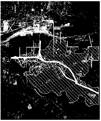
The example stated in Fig. 1 demonstrates the result of a query which
includes  two steps.  The first step means: Select the polygons from
the "LANDUSE" coverage.  The selection will be done by the user (the
user can select several polygons).

The second step means: The system will select the roads which

overlap (even partly) the landuse polygons which were selected

in the first step

A DTP consist of aerial satellite photograph in the background and the
selected terrain items from  the query are displayed.  Given the
principle of the query process, one has to realize that a complex query
can be built using many steps.  The user can operate the query system
"STEP BY STEP" or "ALL STEPS"  in one process.
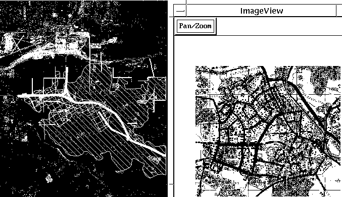
Fig. 2 & 3 demonstrates two queries and its results both regarding the
same polygon, selected by the query.   Fig. 2 shows a detailed raster
map logically connected to the selected polygon.
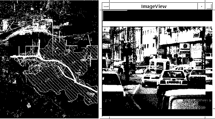
Fig. 3 shows a  photograph, logically connected to the selected
polygon.

SCALE TRANSFORMATION OF GEOGRAPHIC DATA

This application takes place after the DTP has been defined by the
user.

At this stage, the premature DTP is determined for its desired:

      *    Area of interest

      *    Scale

      *    Coverages


The application identifies and controls each coverage which
participates in the DTP, according to its graphic type.  (point, line
or polygon):

POINT BASED COVERAGE

The application analysis the terrain items that exists in each coverage
which are regarded as "POINTS".  A menu appears showing  all the "POINT
SYMBOLS" representing terrain Items that exist in the selected area &
coverage.  The user selects those symbols, that must be displayed in
the DTP. As a result, a group of permitted "point symbols" is created,
for this DPT.

LINE BASED COVERAGE

The application analyses the terrain items that exists in each coverage
which are regarded as "lines".  As a result, a menu appears in which
all the "SYMBOLS LINE" are displayed after a sorting process: the
widest line is displayed at the top of the menu and the thinnest line
at the bottom.

The generalization process consist of two steps.  In the first step the
user decides the width limit.  The user selects a line (displayed in
the menu) and presses the "limit" button.  As a result, all lines which
are thinner than the selected line will not be displayed in the DTP.

In the second step the user controls the "degree of line waviness"
using a slider.  The slider controls the degree of waviness between 0
and 2,000 meters.  The number selected via the slider represents the
limit of minimum distance between each pick points in the "LINE".  When
the value of the slide position is higher, the line will displayed in
the DTP will be smoother.

IF THE COVERAGE CONSISTS OF POLYGONS

The user controls the generalization of polygonalic terrain items in an
indirect manner.  The user controls the boundary lines in the way
described above.  After editing the boundary lines, the polygon display
is determined.

RESULTS

The resulting module is activated, for each coverage participating in
the desired DTP after the completion of the classification process. The
user selects the button "RESULT" and a background process is
activated.  It includes topology tests and creation for points, line
and polygon terrain features.  The new DTP with the desired scale and
specific classification is displayed.

Fig. 4 shows two coverages: one of a DTP with its "BASIC SCALE"

(terrain items are displayed as they are defined in the GIS database)
and the second, after changing the DTP scale and generalization
process.
Joseph Koifman
Manager, GIS Projects, Software Projects
Computerized Systems & CAE
Engineering Division, CAG, Israel Aircraft Industries Ltd
Ben Gurion International Airport, 70100 Isreal
Tel: 972-3-9354636
fax: 972-3-9355049
e-mail: 100274.1735@compuserve.com
Avi Kalcheim
Software Engineer
Computerized Systems & CAE
Engineering Division, CAG, Israel Aircraft Industries Ltd
Ben Gurion International Airport, 70100 Isreal
Tel: 972-3-9358671
fax: 972-3-9355049
e-mail: 100274.1735@compuserve.com