Information processing paradigms and methods for electrical power systems are an important component of an advanced modern electrical power system. Power analysis models and algorithms such as Load Flow, Fault Analysis, and Reactive Power Compensation become major elements for the operation and planning of large electrical power systems. A research project had been started a year ago to provide the Lebanese electrical power system, which is in a recovery/expansion phase after an infrastructure-devastating war that lasted 17 years, with this type of information processing. Considering the fact that existing power analysis software packages are relatively weak or totally unfit in terms of advanced geographical and classical data analysis, user interfaces, and expandability, a GIS-Power Analysis integrated system was developed, and presented and published in the Esri 1994 User Conference. The conceptual design development of integrating a power systems analysis software (developed at the American University of Beirut) with PC ARC/INFO led to an application software described in this paper. The open architecture of the resulting software allowed it to be customized to the end user (the Lebanese electricity company). The new software package and the implementation methodology were built to support the day-to-day operation, control, and planning at the Lebanese electricity company. The conceptual software and database design, the product, and the features and merits of the software are described in detail and sample applications are demonstrated.
INTRODUCTION

The Lebanese electrical utility is currently recovering of a devastating

nation-wide armed conflict that heavily affected the Lebanese Electrical

Power System (LEPS) (Yehia et al 1991).  The currently undertaken

rehabilitation and expansion project will increase the LEPS generation

power from 1100 MW to 2000 MW.  This will be achieved through the

construction of new power plants, the addition of 300 km of transmission

lines and 10 high voltage substations.  The system will also be operating as

an interconnected transmission system.  This expansion program of system

physical components (power plants, transmission lines, substations) should

be accomplished with a state of the art information technology for its

operation and control.  This situation inspired the development of a system

integrating power analysis software within GIS technology.  Such a system

is highly recommended in the absence of a SCADA system (a SCADA

system won't be available at the Lebanese utility before five years).


In the following we will describe the conceptual design of the integrated

system.  Next the system capabilities are described, followed by an

evaluation of its features and merits.  Sample applications of the system are

also presented.


THE CONCEPTUAL DESIGN

The details of the conceptual design can be found in a paper entitled "
-

ing Operation and Control Systems in a Recovering Power Utility" (Yehia

et al 1994).  The integrated system is the result of coupling a power

analysis package (PSACP) to a GIS software package (PC ARC/INFO,

Esri).  The system is a mix of PC ARC/INFO scripts (SML, Esri),

modified PSACP analysis routines (PASCAL), and C++ file processing

routines.  The GIS is used as the system engine, the PSACP was broken

into its analysis constituents and those linked to the GIS engine through

data transfer routines written in C++.  Different new modules were

introduced using the GIS that make the system more useful and powerful

and give a new sense to the technical data produced by the PSACP.  In

what follows are more highlights of the design.


Reengineering of PSACP

The PSACP is a standalone package.  It has its own graphical and user

interface and its own data format.  To integrate it with GIS, the PSACP

was disintegrated into its three analysis components (load flow, fault

analysis, reactive power compensation) and the graphical and user interface

was eliminated.  The elimination of the graphical and user interface

improved the memory performance of the system because it used to

consume an important part of the available memory (the memory is

dynamically allocated by the PSACP to store the data relevant to running

the power flow algorithm).  The result of the disintegration was three

programs, one for each analysis capability.  These three modules were

integrated with the graphical interface and data analysis facilities that come

with GIS (figure 1).  Note that the three modules still need the data in the

format used by the original PSACP.
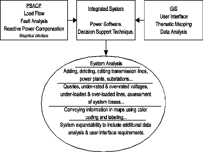
Figure 1. Reengineering the PSACP, the integrated system.


System Block Diagram

The system block diagram in figure 2 shows the relationships between the

disintegrated PSACP, the GIS facilities, the common database, and the

user.  In what follows we describe the components of the system (the

database, the data transfer routines, and the GIS engine).
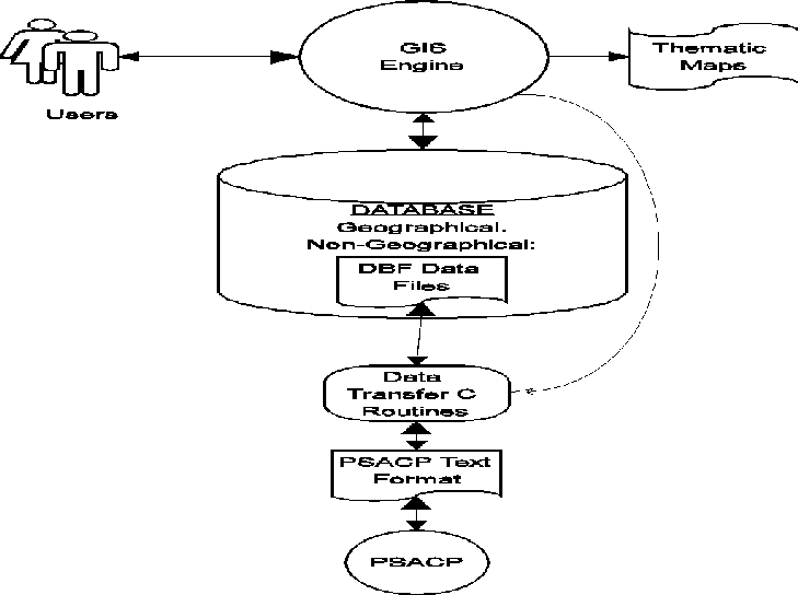
Figure 2. System block diagram.


Database Model for the Integrated System

The integrated system is based on a database model using the GIS format.

The equivalent of PSACP locational files are called coverages in GIS.  The

informational text files of PSACP are transformed into DBF database files

(also GIS format for data files).


Data Communications Protocol

Since the modified PSACP routines still need the information in the original

PSACP database text format, C++ routines were written that produce

those files out of the GIS DBF data files.  The DBF format was decoded

using the proper documentation.  Also, since the modified PSACP routines

write the output information in the original text format, C++ routines were

written that produce DBF format files out of those text files.  The C++

routines and the modified PSACP routines are called automatically from

the GIS scripts.


The GIS Engine

The GIS Engine implements the user interface and the graphical interface.

It is also the front-end development tool for all the system modules

described in the next part.  The design relies on GIS because typical GIS

software are an excellent choice for writing system engines that provide

affordable user-friendliness and powerful analysis and presentation of

results.


THE APPLICATION PRODUCT

The application is based on different functional modules (figure 3).
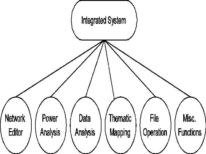
Figure 3. The functional modules of the integrated system.


The Network Editor Module

The network editor module is an interactive graphical and topological

module that allows the user to modify a power system.  Figure 4 shows the

editor screen with the LEPS loaded.  The following is a classification of the

editor's features in three categories, display, edit, and save/exit:


Display Features:
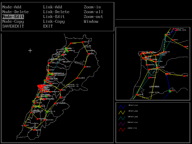
Figure 4. The editor screen showing the LEPS.


The Power Systems Analysis Module

The facilities of this module are provided by the reengineered PSACP

routines:
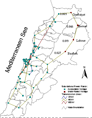
Figure 5. The thematic mapper showing the underrated nodes of the LEPS

and their voltages.


In this application we propose to use the integrated system to do a

comparative analysis of two suggested solutions to the above voltage

problem.  The first consists of planning a transmission line from the Zouk

power plant to the Laboue substation (figure 6), which is one of the nodes

where the voltage is low (Laboue is in the Bekaa region).
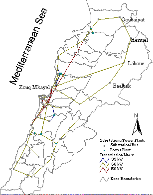
Figure 6. Solution #1: Zouk-Laboue new transmission line.


The second consists of adding a generation plant at Laboue (figure 7).

These two scenarios are actually being considered at the Lebanese

electrical utility.
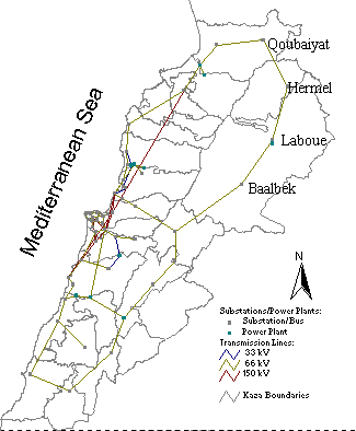
Figure 7. Solution #2: Generation added at Laboue.


Figure 8 shows the node voltages resulting from the first scenario.
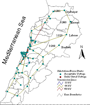
Figure 8. Results of first scenario.


Figure 9 shows the node voltages resulting from the second scenario.  Note

that both scenarios solved the problem (no more underrated nodes).
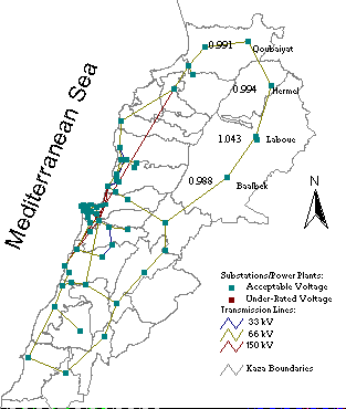
Figure 9. Results of second scenario.


It remains to compare the voltages and do a feasibility study to decide

which one is better.  Note that the planner can rerun the scenarios with

different technical characteristics to determined the minimal physical

characteristics of the plant or the transmission line that solves the problem.


Contingency Analysis in Power Dispatching.

Some elements of the current LEPS are under maximum technical

constraints (overloaded transformers, lines...).  Some transformers are

known to be overloaded for a significant amount of time.  In such a

situation it is very important to study what happens to the system if an

element breaks down.  As an application one can study the system with one

of the transmission lines breaking down then attempt to analyze the effects

of the accident to determine the regions that are most affected.


CONCLUSION AND FUTURE DEVELOPMENTS

The current version of the system is very useful for the planning of the

LEPS and the long term operational strategies.  Future developments of the

system (which are easily implementable due to the open architecture of the

system) will deal with the daily operational decisions (dispatching).  The

view is to add proper interfaces that allow the user to enter hourly load

information written on a computer file, to graphically switch circuit

breakers on and off, producing a tabular output of the status of the

switches and transmitting those to the substations.  Options for dispatching

can be planned before hand (daily) based on statistical descriptions of the

loads for the different times of the day.  Other future developments will

come up based on the utility's needs for specific queries (within the frame

of the database design).


REFERENCES

M. Yehia and A. Zobian.  "An Improved Algorithm for Fast Decoupled

Load Flow."  Proceedings of the ISMM international conference on

computer applications and design simulation and analyses, Orlando, March

1992.


M. Yehia, G. Yared, and M. Bridi.  "
-ing Operation and Control

Systems in a Recovering Power Utility."  The Proceedings of the

Fourteenth Annual Esri User Conference, May 1994.


M. Yehia, I. Ghandour, M. Saidy, and V.A. Stroev.  "Reactive Power

Optimization in Large Scale Power Systems."  Electrical Power & Energy

Systems Vol. 14 No 4 (August 1992): 276-283.


M. Yehia, M. Saidi, H. Diab, and K. Kabalan.  "The Lebanese Electric

Power System Operational Problems."  IEEE Power Engineering Review

(September 1991): 15-16.