Georgia Aifandopoulou, Teti Nathanail, Demetrios Panayotakopoulos
ETIS : A GIS technology based tool for supporting strategic
environmentally friendly planning of urban transport infrastructure
development
1. Introduction
Strategic transportation planning for an urban area constitutes a
complicated process which requires extensive data collection and
analysis, and the implementation of a number of travel demand
forecasting, environmental assessment models and evaluation
methodologies.
At present, there is a number of available software packages supporting
individual tasks of the strategic transportation planning process.
However, these tasks, heavily interrelated to each other, indicate the
need for an integrated computer environment which facilitates the
overall planning process by providing automated data exchange among the
packages, scenarios development and simultaneous evaluation of the
results obtained by each package.
ETIS (Environment Transport Integrated planning System) constitutes a
state-of-the-art system which supports the integrated application of
all the tasks involved in the transportation planning process, i.e.
travel demand forecasting, development of alternative transport
infrastructure and policy scenarios, evaluation of the socioeconomic,
traffic, and environmental impacts of the scenarios, cost-benefit
analysis, comparison of alternative scenarios, and graphical
representation of the involved evaluation indices.
The system has been developed by the TransEuropean Consulting Unit of
Thessaloniki (TRUTh S.A.) for the purposes of the EEC financed study
(PHARE No. 604/91) entitled "Master Plan Study for an Environmentally-friendly Transport System in Budapest" undertaken by the company. The
study included the development of travel demand forecasting models and
the testing and evaluation of different alternative Transport
Infrastructure development schemes for the city. The time horizon of
the planning process was extended to the year 2010. The consultant
undertook the task of developing alternative test-networks and
evaluate them on the basis of the impacts the proposed infrastructure
development may have to the traffic conditions of the city and the
environment.
Finally the prioritisation of the proposed developments
was based on the predicted economic benefits and costs associated with
them. This last task imposed the expression of environmental impacts of
each scenario in monetary terms, fact which directly led to the
calculation of evaluation indices which are not taken into account by
the conventional traffic impact and environmental assessment
forecasting tools. The integration of the ArcInfo functionalities in
ETIS was made in order to support the calculation of these specific
evaluation indices and to provide decision support for transport
infrastructure development.
2. Main Issues of the Strategic Transportation Planning
Strategic Planning of Urban Transport Infrastructure Development has
always been a critical issue for decision makers since it involves :
- analysis of the interrelation between land use and transport
infrastructure development
- travel demand forecasting and modelling
- formulation of alternative transport infrastructure development
scenarios
- assessment of the impacts of the scenarios on the traffic and
environmental conditions of the study area.
- evaluation of alternative solutions which includes prioritisation
of the objectives and measurement of the performance of the
solution for achieving the objectives.
Transport Planners involved to strategic Environmentally friendly
Planning of Transport Infrastructure are usually conformed with time
consuming and respective tasks, which involve :
- handling of big volume of data (i.e. socio-economic data, land use
data, transport cost data etc.) used for Traffic modelling and
forecasting,
- creation of transport infrastructure supply inventory (including
all geometrical and operational characteristics of the Road and
Public Transport network)
- specification of alternative solutions, (sets of road and Public
Transport Infrastructure with all the operational characteristics
the planner desires to test on them)
- calculation of indices for assessing the impacts of alternative
proposals,
- traffic indices are: V/C ratio, traffic flow, delay, transit
time between specific OD pairs, Total passenger-Kms, Total
passenger-hours on the network etc.
- environmental indices are: emission rates by link, noise levels
by link, population exposed to different pollution and noise
levels, percentage of urban surface where pollution conditions
have been improved.
- testing of alternatives scenarios and evaluation of the results
(calculation of traffic and environmental conditions)
- presentation of results and justification of the proposed solutions
(compare traffic and environmental results)
For supporting some of the specific tasks of the above mentioned
planning process specialised software packages are available, for
Traffic modelling (EMME/2, MOTORS etc.) and Environmental Impact
assessment (PAL, MARS, MEMO, etc.). Although this type of software
packages are usually implemented parallel for the purpose of the
Transport Infrastructure planning process, they have never been
integrated in a single computer environment in order to provide
assistance during all the steps of the planning and decision making
process related to the Transport Infrastructure development.
Since the different types of data involved in the Transport
Infrastructure Planning process follow a spatial distribution i.e.
refer to geographical entities such as links, nodes, areas (zones), the
application of GIS technology for developing an Integrated
Transportation Planning Tool with special attention to the
Environmental Protection is more than evident.
3. The ETIS Architecture
ETIS constitutes a computer environment in which ArcInfo workstation
version 6.1.2 (Geographical Information System), EMME/2 workstation
version 6.0 (Traffic Modelling Software), and PAL workstation version
2.1 (environmental pollution model) has been fully integrated for
supporting:
- Planning of Transport Infrastructure and
- Management of transport operations in urban areas (i.e. Management
of Public Transport Networks).
Since each one of the above software packages provides functionalities
for supporting the same type of user generations (such as
Transportation network description, results' presentation, etc.), it
was critical for the ETIS design to assign specific roles to each one
of the integrated software which corresponds to the support of concrete
steps of the considered Planning Process. The role allocation among the
integrated software application presented in the following paragraphs
was based on :
- the evaluation of the efficiency and user friendliness of the
functionalities provided by each software package for a specific
task i.e. data modelling
- the minimisation of the necessary data transfer and data conversion
actions throughout the process
- the facilitation of data updating.
The role of each software package as a component of the integrated
architecture can be identified as follows:
- ArcInfo handles all geographical and descriptive data related with
the areas of the city involved in the Planning process and also the
data related with the geometrical and operational characteristics of
the Public Transport and Road Network. It also supports the
evaluation of the traffic and environmental results for each scenario
of the transport infrastructure development scheme and the
comparative presentation of these results.
- EMME/2 supports the modelling and forecasting activity i.e. the
estimation of traffic volumes on the proposed transport
Infrastructure, based on the forecasted evolution of socio-economic
indices of the urban area, the transport cost predicted for the
specific time horizon and also the modal split patterns for this
horizon.
- PAL software performs, on the basis of the traffic volumes estimated
on each specific link by EMME/2, the calculation of the emission
rates for each major air pollutant and also the emission
concentrations of the study area.
The overall system architecture is presented in figure 1.
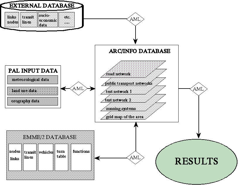
Figure 1. ETIS Architecture
3.1 Database design
Taking into account that EMME/2 and PAL application have their own
internal database structure the integration of them with ArcInfo was
based on the development of an Integrated Data Base Management System
and specific interfaces for data transfer and conversion.
The ETIS database structure is shown in figure 1. It comprises :
- external database including network functional and descriptive data,
historic of traffic and socio-economic, and environmental data in
different data formats (ASCII files, DBASE files etc.)
- ArcInfo Database organised in different layers for road Network,
Public Transport Networks, alternative zoning systems, alternative
infrastructure development scenarios. The geographical database
comprises geometrical and functional characteristics for each link,
node and zone involved in the network Management Process.
- EMME/2 database organised according to the EMME/2 internal data
structures, comprising network descriptive characteristics, public
transport transit lines, functional characteristics, origin-
destination demand matrices, traffic forecasting models expressed as
mathematical functions.
- PAL database including orography data, weather conditions data,
summary of network descriptive data, emission and concentration
pollution level prediction models, in the format of mathematical
functions.
- Geographical database of results including the appropriate data
structure for storing traffic and environmental results for each
transport network development scenario.
3.2 ETIS functional modules
The Operational diagram of ETIS is shown in figure 2.
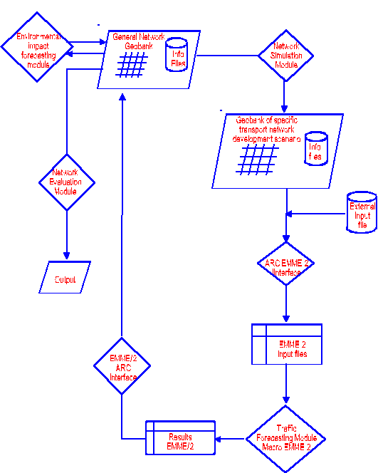
Figure 2. ETIS Operational Diagram
The functional modules of ETIS has been formulated as follows :
- NETWORK MANAGER : Developed fully in ArcInfo Environment, by using
ArcInfo macro language, this module supports data manipulation for
automatic creation of test-networks (alternative sets of Road and
Public Transport Proposals), for which the planner wishes to estimate
and evaluate the traffic and environment impacts on the urban area
under study. The module supports data entry, proposals selection and
illustration of the network of different modes (Road / Bus Network /
Tram Network / Metro Network / Pedestrian Network / Parking areas
etc.). The module also creates automatically the data structure
required for the successive steps of the Traffic Modelling and
Forecasting process.
- ArcInfo to EMME/2 interface : Developed in ArcInfo AML and C
programming languages, this module transforms the data stored in the
ArcInfo data base and creates automatically the input files for
EMME/2 in the appropriate format. This data conversion eliminates
errors usually occurred when the EMME/2 data base is formulated
manually and from scratch every time a test network is to be checked.
- EMME/2 Traffic Modelling and Forecasting module. This is a macro file
easily addressed by the user, comprising series of EMME/2 macro
commands which read the necessary EMME/2 input process files,
performs matrix calculations involved in each step of the traffic
forecasting (trip generation/ trip distribution / modal split) and
runs the corresponding EMME/2 modules for traffic assignments. The
macro files give the capability to the user to estimate the travel
patterns of the city for different time horizons. The knowledge of
the socio-economic and land-use indices of a considered time horizon
is a prerequisite for the implementation of the travel forecasting
models incorporated in the EMME/2 macros. Based on the future
socioeconomic indices provided by ArcInfo, the macro estimates the
passenger trip productions and attractions and reserves this
information for the implementation of the trip distribution, modal
choice, and trip assignment models incorporated in this ETIS module.
- The EMME/2 to ArcInfo Interface. This module converts the EMME/2
output files in ArcInfo format and inserts them automatically in the
ArcInfo data base in order for them to be used by the next modules
for test network comparison and results� presentation in graphical
format.
- Environmental Conditions estimation module. This module consists of
two specific parts the air quality module (PAL) and the noise level
estimation module (developed in ArcInfo) environment. The module
calculates emission rates and noise level by link. It also calculates
concentrations of the main pollutants for each considered test
network, over the study area.
- Test Network Evaluation module. Developed in ArcInfo environment,
this module uses the already stored in the ArcInfo data base results
of each test network and calculates evaluation indices such as
population exposed to different levels of air and noise pollution,
population for which trip duration for reaching specific land uses
has been reduced by 10/15/20% etc. The module is also capable to
present in electronic coloured maps comparative results of the test
networks according to the specific queries of the user.
Figures 3 and 4 illustrate examples of the developed menus of the ETIS
Evaluation module.
4. ETIS application to the Budapest Environmentally friendly Transport
Infrastructure development Study.
ETIS has been used for the Budapest Transport Master Plan Study and
provided valuable assistance for decision making in a very conflicting
decision making process which was constrained by the limited budget
available for Transport Infrastructure Investment in the city. ETIS
provided quick and valuable answers to the following questions:
- Which Transport Infrastructure projects to consider for the
Transportation System Development?
- What traffic flows and Environmental conditions will result by the
realisation of each set of Transport Infrastructure development?
- Which scenario is more beneficiary from the point of air quality,
noise, and traffic conditions improvements throughout the Transport
and the city environment?
- Given the limited financial resources which priorities apply to the
infrastructure developments?
The actions undertaken by ETIS in the context of the Transport Master
Plan Study of Budapest can be listed as follows:
- development and calibration of the Traffic forecasting models for the
city
- development of detailed transport supply inventory for all active
modes in the city
- Network formulation and testing: One of the main benefits of the
system is the ability it provided to the planner for the development
and testing of a large number of alternative scenarios. Minor or
major changes on the network infrastructure, parking spaces and
policies, operational characteristics of the various modes operating
in Budapest, traffic calming and environmental alert policies were
modelled, using the functionalities of ArcInfo. ETIS automatically
adjusted all the updated information, converted it to the format
required by the traffic, environmental, and evaluation models, and
computed the indices which set the planner able to obtain measures of
performance of the overall transportation system and the individual
proposed developments.
All the resulting indices were produced in a
comprehensive graphical form, in order for analysts and decision-
makers, regardless of their scientific background, to be able to draw
conclusions. Initially, eight alternative scenarios for the
Transportation System were tested, three of which were selected for
further analysis and evaluation. The evaluation relied on traffic
(e.g. travel time, travel delay, speed), environmental (CO, HC, and
NOx emission rates and concentration, noise level), social (time
loss, number of people affected by the pollution, accessibility, and
costs involved) and economic (construction, maintenance, operational,
land acquisition cost) indices for individual links, facilities,
areas, or systems. Also, combination of the results was achieved
(e.g. pollution per unit length, number of inhabitants exposed to a
certain level of pollution, travel time contours from a certain zone
and population within each contour). Figure 3 is an example of the maps
created by ETIS to demonstrate the proportion of population exposed to
different levels of pollution.
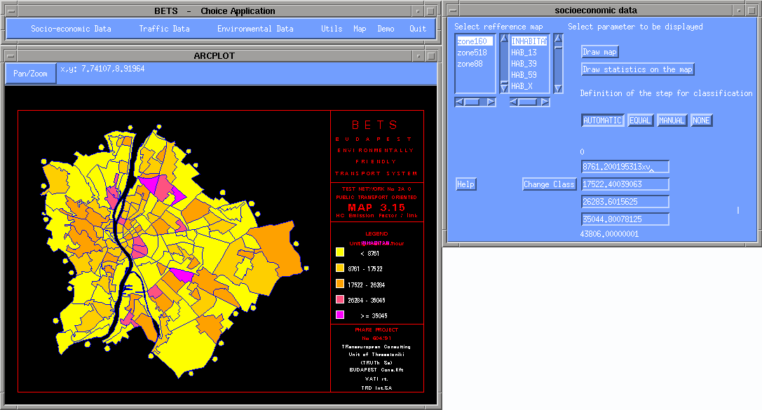
Figure 3. Pollution levels and affected population in Budapest
- Comparison of alternative scenarios. The comparison of alternative
scenarios was enabled through the implementation of ETIS, and
expressed in numeric figures or described graphically in coloured
maps. An example of the comparison of the operational speeds between
the road transport oriented and the public transport oriented
scenarios is illustrated in figure 4. The colors indicate the levels
of diference between the scenarios speed.
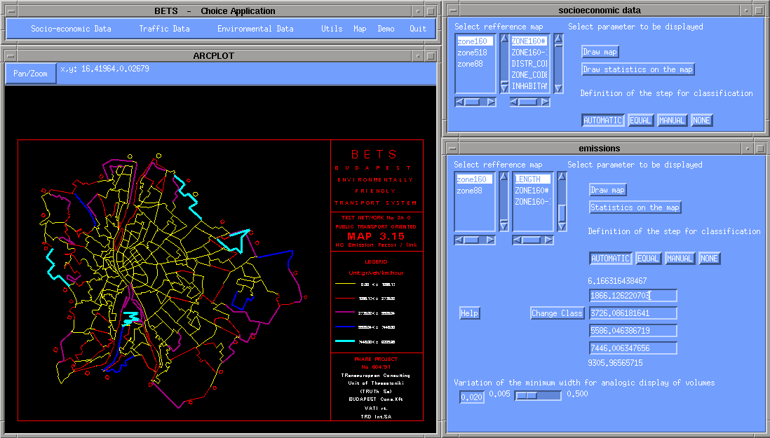
Figure 4. Speed comparison between alternative scenarios in Budapest
5. The Benefits of the ETIS Implementation in the Transport
Infrastructure Planning Activities.
The benefits obtained by the Planning process from the ETIS integration
of specialised application can be summarised in the following :
- exploitation of the advantages of each software package through
their integrated use
- fast examination and evaluation of a big number of alternative
infrastructure development sets by the user in the form of
scenarios (i.e. change of data sets, change of basic parameters
etc.)
- automatic transformation of data sets in the format of input files
required by each software application used in the Integrated
Environmentally friendly Transport Planning Process
- presentation of the results in a user-friendly way. The actual
advantage is given by the advanced functionalities of the ArcInfo
software
- real, and not abstract, representation of the zoning systems, and,
also, of the road and the other networks (GIS software)
- easy and efficient update of the basic data such as network
electronic maps, socio-economic data etc.
It must be mentioned that the functionalities made available by ETIS
through the Integration of the GIS technology with specialised traffic
and environmental impact modelling tools, provide the means for
performing, at strategic planning level, both quantitative and
qualitative evaluation of the impacts the alternative Transport
Infrastructure development scenarios may have on the traffic and
environmental conditions of the study area. The Evaluation module of
ETIS provides to the planner and the decision makers sufficient
information for justifying any decision at an early stage of the
Planning Process which usually takes place in a very conflicting
decision making environment.
6. Conclusions
A tool has been presented which facilitates the transport planner to
model and evaluate alternative transport infrastructure and Transport
policies scenarios. A number of existing software packages (including
the more sophisticated traffic forecasting tool EMME/2), which support
individual tasks of the planning process have been integrated in the
ArcInfo environment, making use of the valuable GIS functionalities in
order to fully exploit the capabilities of the individual packages.
Specifically, a user-friendly menus lay-out has been created which
calls a number of ArcInfo AML programs for data handling and analysis,
evaluation indices calculation and result presentation.
The system has
been successfully applied in the Budapest Environmentally friendly
Planning of Transport Infrastructure Development providing variable
results, reducing the time allocated to the Planning activity and
facilitating the decision making process.
Georgia Aifandopoulou
Senior Transportation Engineer
TRUTh S.A.
18 Navarinou Sq.
54622, Thessaloniki, GREECE
Telephone: (3031) 283722
Fax: (3031) 262784
Email: gogo@hermes.civil.auth.gr
Teti Nathanail
Senior Transportation Engineer
TRD International S.A.
18 Navarinou Sq.
54622, Thessaloniki, GREECE
Telephone: (3031) 242337
Fax: (3031) 262784
Email: teti@hermes.civil.auth.gr
Demetrios Panayotakopoulos
Senior Computer Analyst - GIS Expert
Aristotle University of Thessaloniki
Department of Civil Engineering
Transportation Laboratory
Egnatia Str.
54006, Thessaloniki, GREECE
Telephone: (3031) 995836
Fax: (3031) 995789
Email: jim@hermes.civil.auth.gr