Ye, Woo-Sung, Lee, Hee-Sun, Lee, Kyoo-seock
Application of the GIS in the Hydrologic Effects Caused by
the Second Collective Facility Area Development in Mt. Kyeryong National Park
The National Park is to be preserved in accordance with the purpose
of the law establishment. However, the development has resulted in
degrading the park environment. Especially, the collective facility area
has been developed for the commercial benefit rather than for the preservation.
So, it is necessary to figure out the impact of the development plan proposed.
Thus, the purpose of this study is to explore the hydrologic effects due to
the second collective facility area development in Mt. Kyeryong National
Park using the Geographical Information Systems (GIS). The Rational Method
and the Soil Conservation Service (SCS) Method were used to estimate the
runoff volume. During this procedure, GIS software, ArcInfo was used to
integrate, manipulate, and calculate the attribute value of a number of
polygons which represent each land use characteristic. A program was
written to compute the attribute value of each polygon and to estimate the
difference of peaktime runoff volume before and after construction.
keyword: runoff volume, rational method, collective facility area,
GIS (Geographic Information Systems).
I. Introduction
  The National Park is to be preserved in accordance with the purpose of
the law establishment. However, the development has resulted in degrading
the park environment. Since 1980s, the pressure for recreational purpose
results in active development of park facilities for the user (Park, 1991).
Especially, the collective facility area has been developed for the
commercial benefit rather than for the preservation. So, it is necessary
to figure out the impact of the development plan proposed.
  As a means to handle these problems properly, Geographic Information
Systems (GIS), tends to be frequently used to manage park resources and
facilities (Suh, 1991). The U.S. National Park Service has been extensively
using GIS in park resource management, and developing GIS databases about
its 28 parks for more than ten years (Fleet, 1987).
  The hydrologic model was combined with GIS to figure out the hydrologic
effects.  A program was developed by combining MIKE 11 and GIS to predict
and handle the flood-prone area in Denmark (Lingberg et al., 1993).
In the United States, HEC model was combined with GIS for the graphic user
interface(Kragt et al., 1993).
  The construction of the second collective facility area  in Mt. Kyeryong
would affect the topography and landscape, the ecosystem, wildlife, hydrology.
Especially the increase of peaktime runoff and soil loss potential make effects
in hydrology. Thus, it is necessary to figure out the hydrologic effects
analytically.
  Therefore, the purpose of this study is to figure out the change of
peaktime runoff caused by the construction of the second  collective
facility area in Mt. Kyeryong National Park using the Geographical
Information System (GIS).
II. The Study Method
2.1. Conceptual Framework of the Study
The large scale development of collective facility area within the
National Park results in the change of land cover from heavily wooded
forest to impervious area. Consequently there is a increase of peaktime
runoff, and soil loss potential which deteriorate the park environment.
Thus, it is necessary to figure out the hydrologic effects by calculating
the difference of peaktime runoff between before construction and after
construction. After the selection of the appropriate peaktime runoff
estimation method, locational data and attribute data are integrated within
GIS to figure out the hydrologic effects in the site. The concept of this
study also inclues developing the user-customized program which can be
applied to other sites.
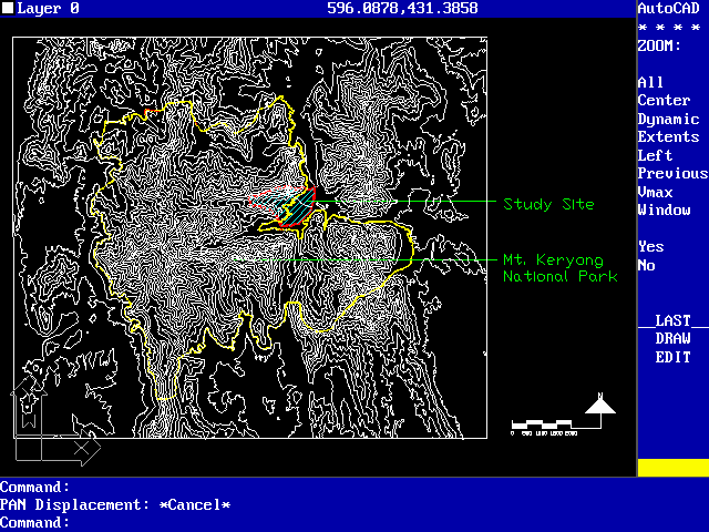
2.2. Study Site
The study site is the second collective facility area in Mt. Kyeryong
which is located near Taejeon Metropolitan Area. There are lots of one-day
visitors in the Park because of convenient accessibility. The total area
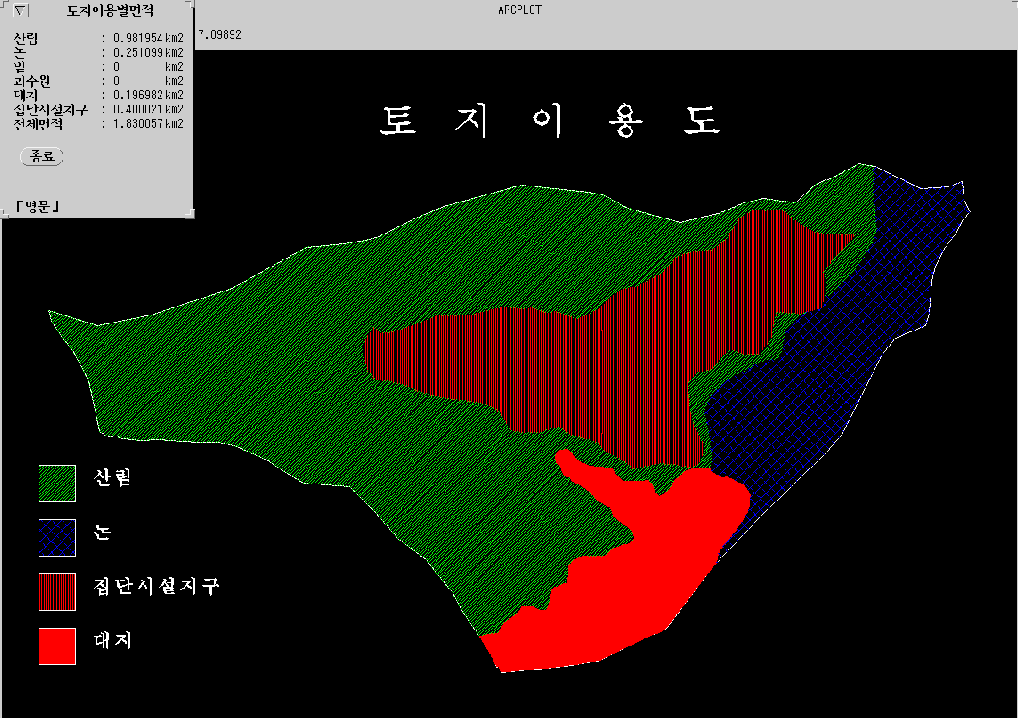
of the study site is 1.83km2, which covers the whole watershed concerned.
There are now two existing collective facility areas in Mt. Kyeryong
National Park. They are Tohnghahk-temple (the first) collective facility
area and Kahp-temple collective facility area. The study site has been
developing after the foundation of the hot spring. The present construction
within the site would results in degrading the landscape in the mountain,
and deteriorating the hydrological environment because more than 85% of the
site is steeper than 20% slope (Kohngju County Government, 1988).
2.3. Hardware and Software Used
The following hardware and software are used in this study. They are
SparcStation II (Graphic processer and monitor, 1.8 Gigabyte Hard Disk
Drive), Calcomp 9100 A1 size digitizer for data input, IBM-compatible
486DX2 (66MHz) PC, PC AutoCAD release 12, ArcInfo version 6.1.1,
which are all at GIS laboratory at the Department of Landscape Architecture,
Sung Kyun Kwan University
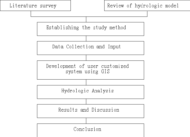
2.4. Study Procedure
As described in Figure 2, the study procedure is as follows:
1) To review the relevant research and hydrologic models,
2) To select the appropriate method of peaktime runoff estimation,
3) To collect the necessary data and enter them in GIS,
4) To develop the User-customized program using GIS,
5) To apply the hydrologic analysis in the site,
6) To get the results and discuss them,
7) To derive the conclusion
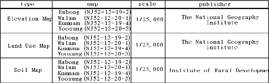
2.5. Input Data
As described in Table 1, the source of the locational data and
elevation is 1:25,000 scale topographic map published by the National
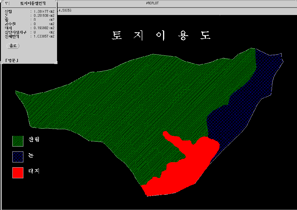
Geography Institute. For the land use map, the information was derived
from the interpretation of 1:25,000 scale topographic map, and the field
check. Most of the site is heavily-wooded forest. So, the classification
of the land use was not so difficult for estimating peaktime runoff.
The 1:25,000 scale detailed soil map published by the Institute of Rural
Development was used, and the slope information was derived from the
topographic map using Triangulated Irregular Network (TIN) in ArcInfo.
2.6. Estimating Peaktime Runoff Using the Rational Method
2.6.1. Estimating peaktime runoff
The following rational method equation was used,
Q = 0.2778CIA 8)
where:
Q : the runoff in cubic meter per second (m3/sec)
C : the runoff coefficient
I : the average rainfall intensity in milimeter per hour (mm/hr)
A : the area of the watershed (Km2)
0.2778 : unit conversion coefficient
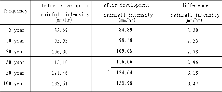
There are 5-year, 10-year, 20-year, 30-year, 50-year, and 100-year
frequency return, and the corresponding runoff for every frequency
was estimated.
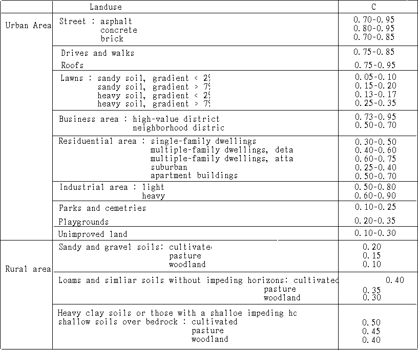
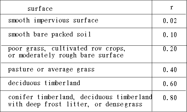
2.6.2. runoff coefficient (C)
There is a wide range of values for each land use, slope, the ratio
of vegetative cover, soil type, watershed type, and surface condition.
Because the runoff coefficient accounts for a number of different
variables, a composite value of C was used. Theoretically there is a
range of 0.0 -1.0. However, the range of 0.05 - 0.95 is used actually
(Yoon, 1993).
The following runoff coefficients in Table 2 were used in this study.
2.6.3. the Rainfall Intensity
    The rainfall intensity depends on the return frequency, the relationship
between rainfall duration-rainfall intensity for a given  return
frequency, and the time of concentration.   As the time of  concentration
increases, the intensity decreases, and vice  versa.   So, the rainfall
intensity is inversely proportional to the time of  concentration.   The
equations frequently used in Korea are as follows (Yoon, 1993):

 Tallbot type   I = a / ( t + b)
 Sherman type   I = c /  t**n
 Japanese type  I = d / ( (t**0.5) + e )

where:
 I = rainfall intensity (mm/hr),
 t = time of concentration, travel time
 a,b,c,d,e,n = coefficients from the figure based on rainfall intensity and
               frequency curve
  The rainfall intensity equation in this study is based on the value of
statistical results from the estimated precipitation in the  open channel
plan in the urban stream and sewer (Lee, 1991).  Because there is no avaliable
coefficient value in Mt. Kyeryong, the value in Choopoong-Nyeong Area
was used in this study, which is the nearest one to the study site in terms
of location.  Tallbot type is used for Choopoong-Nyeong Area.
  The travel time is the average time required for water to flow from the
hydraulically most distant point of the watershed to the outlet.  The Kerby
formula was used for the calculation of the travel time, which is widely
used in the hilly terrain in Korea (Lee, 1991).  The formula is as follows:

    t = 3.03( rL**1.5 / H )**0.467
    t : travel time in hours (hr)
    r : roughness coefficient in Table 3.
    L : the flow length in kilometers (Km)
    H : the elevation difference in meters (m)
2.7. Estimating the Total Runoff Using the SCS Method
2.7.1. Estimating the Total Runoff
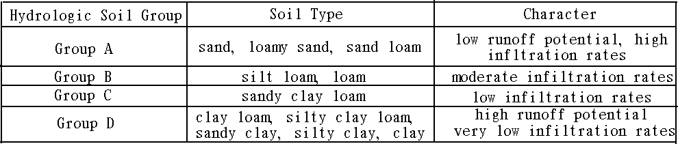
In the SCS Method, the amount of the total runoff is affected by soil
type, land use or plant cover, cover treatment, and the hydrological
characteristic of the soil within the watershed boundary. Quantitative
measurements for the runoff affected by these factors are suggested in the
SCS Method. The Antecedent Moisture Condition (AMC) before precipitation
needs to be considered also. However, only the case of AMC-II is
considered in this study.
The relationship between the total precipitation and the total runoff is
suggested as in the following equation (Yoon, 1986).
Q = ( P - 0.2S)**2 / ( P + 0.8S )
where:
Q = the toal runoff in milimeters (mm)
P = the total precipitation in milimeteres (mm)
S = the potential maximum retention of a site (mm)
The terms S and Ia are both affected by the character of the land cover
and soil condition. So, the relationship is demonstrated as we can see in
the following equation.
Ia = 0.2S
S, the potential maximum retention is a function of such variables as
soil, plant cover, and the amount of impervious area, runoff curve
numbers (CN) are made after a detailed analysis to model these effects for
various soil types and land cover complexes - hydrologic land-cover
complexes. The CN for a given set of surface cover and soil conditions is
used to estimate the value of S (Yoon, 1986).
S = ( 25,400 / CN ) - 254
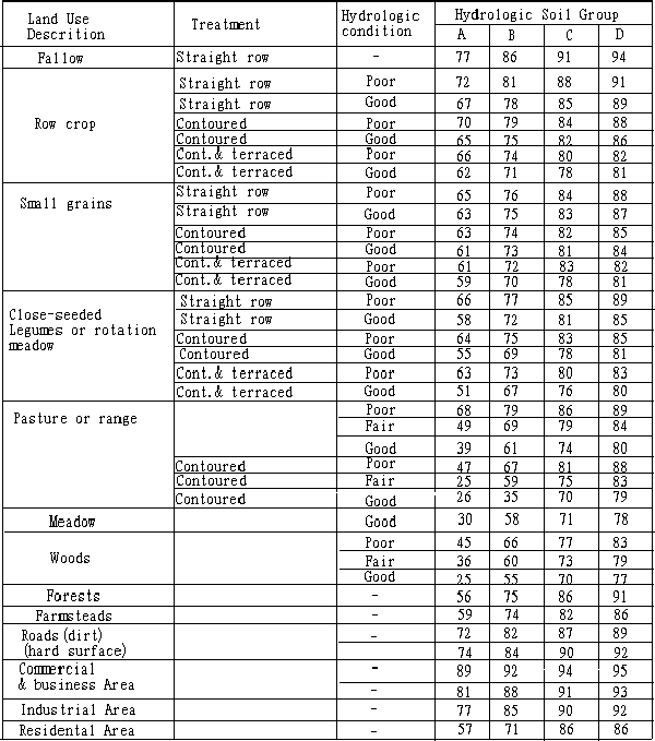
The following hydrologic land-cover complexes in Table 4 were used in this
study.
   The relatinship between the total precipitation and the  total runoff is
affected by the land  use type and cover treatment as well as  the soil type
within the watershed.   Table 5 shows the runoff curve number used in this
study according to the land use, cover treatment, and the  hydrological
condition of the soil.
2.8. the Application of Unit Hydrograph
2.8.1. Nakayasu Unit Hydrograph
Nakayasu has made no-dimension hydrologic curve after by integrating
the variables of unit hydrograph derived and topographical characteristics
from several watersheds in Japan. The unit hydrograph
for a certain time of duration can be made using this curve (Yoon, 1986).
if L < 15km, tg = 0.21L**0.7
if L > 15km, tg = 0.4 + 0.058L
tg = 0.47(AL)**0.25
tp = 0.8tr + tg
Qp = 0.2778R0A / 0.3tp + tk
where:
L = the flow length (Km)
tr = unit time (hr)
tg = the travel time from the time of 0.8tr to the peaktime (hr)
tp = peaktime (hr)
tk = the function of watershed shape factor (the area, flow length,
stream gradient)
R0 = the total runoff (mm)
Qp = peaktime runoff (m3/sec) by unit time tr, and the total runoff R0
The rainfall duration is assumed to be 0.5 hour, and the total runoff is
estimated using the SCS method in this study.
2.9. Using the GIS
Vector Based Topology with the Relational Database Mangement
System (DBMS) can handle the locational data and attribute data
simultaneously. The user-customized program to calculate the peaktime
runoff for a given condition has been developed using Arc
Macro Language (AML) in this study. Using this program the change of
peaktime runoff is calculated automatically by the change of the land cover
due to the collective facility area development.
This program calculates the runoff coefficient, roughness coefficient,
rainfall intensity for a given return frequency, the area of the
watershed automatically. It uses menu-driven approach for user interface.
So, this program can be used in other sites if the necessary corresponding
data are available.
III. Results and Discussion
After developing the program, it was applied in the study site. The
detailed results are described below.
3.1. Peaktime Runoff Using the Rational Method
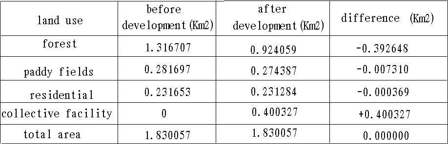
As we can see in Table 6, the collective facility area occupies
21.87% (0.40km2)) of the site after the construction. It consists of
1.82% (0.0073Km2) of paddy fields, 98.08%(0.39Km2) of forest, and
0.09% (0.00036km2) of residential area, respectively. So, most of the area
is heavily wooded forests.
  The change of runoff coefficient and roughness coefficient  directly
affects the peaktime runoff.  The average runoff coefficient of the study
site is 0.3245 before construction, 0.4337 after the  construction.   So,
there is a net increase of 0.1092 in runoff coefficient.
   Table 7 shows the change of rainfall intensity that there is a
2.20mm/hr increase for 5-year frequency, and 3.47mm/hr for 100-year
frequency.
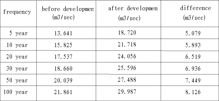
   The peaktime runoff increase by 5.079m3/sec for 5-year freqency,
by 5.893m3/sec for 10-year, by 6.519m3/sec for 20-year, by 6.936m3/sec
for 30 year, by 7.449m3/sec for 50-year, by 8.126m3/sec for 100-year,
respectively as we can see in Table 8.
3.2. Estimating Runoff Using the SCS Method
The value of 104.38mm was used, which is the five-year (1989-1993)
average maximum precipitation of Taejeon meteorological observing station
covering the study site. The Taejeon station is derived from the
nationwide meteorological station Thiessen network figure. Table 9 shows
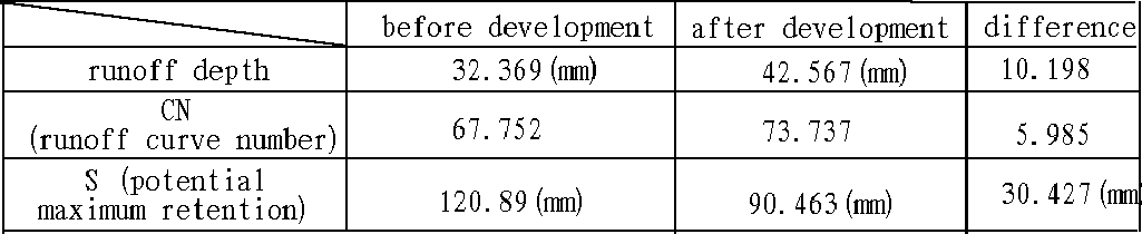
that CN increased by 5.99, S decreased by 30.43mm, and the total runoff
increased by 10.198mm after construction.
3.3. Unit Hydrograph Method
   The peaktime runoff was estimated by Nakayasu Method using the total
runoff from SCS Method.  When rainfall duration is 0.5 hour,  the
peaktime runoff increased by 6.56(m3/sec) due to the  development as we can
see in Table 10.

3.4. Discussion
From the study results, the following problems need to be considered
more.
1) The peaktime runoff increase can be managed by the appropriate
drainage design. However, the deforestation, the change of plant
cover and the flow channel, and the long construction period (1991-2001)
may result in the severe soil erosion, and land slide. So, the study for
the amount and spatial pattern of soil erosion and, handling method need to
be done. More than 85% of the site is steeper than 20%, which can cause
the damage during the construction. In drainage design, the return
frequency should be more than 5-years.
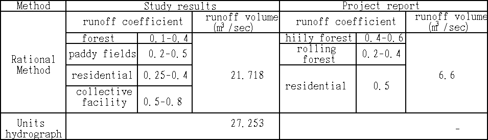
2) There is a difference of 15.118m3/sec peaktime runoff by the Rational
Method, 20.653m3/sec by the unit hydrograph in the case of 10-year frequency
compared with the Master Plan Report as we can see in Table 11. It was found
that the the travel time (121min) and the runoff coefficient value (0.4) used
were much different from the estimated ones (before development: 17.0 min,
after development: 15.6 min) (before development: 0.3245, after development: 0.4337) in this study.
 3) In this study, peaktime runoff for the return frequency was not used
in the unit hydrograph method, which makes it difficult for the result to
be compared with one from the Rational Mwthod. However, the peaktime
runoff (27.253 m3/sec) from the unit hydrograph is similar to one (27.488
m3/sec) from the Rational Method from Tables 8 and 10.
3) In this study, peaktime runoff for the return frequency was not used
in the unit hydrograph method, which makes it difficult for the result to
be compared with one from the Rational Mwthod. However, the peaktime
runoff (27.253 m3/sec) from the unit hydrograph is similar to one (27.488
m3/sec) from the Rational Method from Tables 8 and 10.
IV. Conclusions
This study explores the hydrologic effects due to the second collective
facility area development in Mt. Kyeryong National Park using the GIS. The
Rational Method and the SCS Method were used to estimate the runoff volume.
The following conclusions are derived.
1) The peaktime ruoff volume in the Comprehensive Plan Report was much
smaller than the estimated one in this study. It was found that the travel
time (121 min) was overestimated compared with ones (before development: 17.0
min, after development: 15.6 min) in this study and the runoff coefficient
value (0.4) was different from ones (before development: 0.3245, after
development: 0.4337) in this study.
2) ARC Macro Language (AML) Programming was effectively used to integrate
and manipulate the graphic data and attribute data simultaneously for the
runoff volume estimation. So, the user-customized, estimated runoff program
was developed. It can be used to other sites.
The limitation of this study is that there was no peaktime runoff
according to each return frequency in unit hydrograph method. Also, the
soil loss erosion needs to be studied, in advance, because of the long
construction period and unsuitable gradient (more than 85% of the site is
steeper than 20% slope)9).
References
- Park, J. C., 1991, Strategy of Alternative National Park Facility
Development, Jour. of Korean Soc. of Landscape Architects, 19:156-158
- Suh, C. W., 1991, A Study on the Application of the GIS for National
Park Management, Graduate School of Environmnetal Studies, Seoul National
University, Unpublished Master's Thesis, 89p.
- Yoon, Y. N., 1986, Engineering Hydrology, Seoul, Cheongmon-Gahk, pp537-547.
- Yoon, T. H., 1993, the Rational Method and Drainage Pipe, Proc. of the
1st Hydrological Engineering Workshop, pp.1-19.
- Lee, W. H., 1991, Hydrology, Seoul, MoonWoonDahng, pp.48-49.
- Kohngju County Government, 1988, Master Plan and Basic Design for
Tohnghak-temple Host Spring Development, 122p.
- Fleet, H., 1987, Placing GIS technology into the hands of the decision
maker: The National Park Service Experience, Proceeding of GIS '87.3:91.
- Lingberg, S., W.J.Syme, and H.G. Mueller, 1993, Floodplain Management
with ArcInfo and MIKE 11, Proceeding of the 13th Annual Esri User
Conference, 3p.
- Kragt, J.E., B.E. Baker, and T.J.Rourke, 1993, A GIS Decision support
tool for modeling and managing flooding and dam failure for the readiness
management system, Proceeding of the 13th Annual Esri User
Conference, 93p.
- Ferguson, B.K., 1990, On site stormwater management: Application for
landscape and engineering (2nd ed.), New York, pp.19-54.
Ye, Woo-sung
1/13 Passfield St.
West Brunswick 3055 Australia
Lee, Hee-sun
Graduate Student, GIS Laboratory
Dept. of Landscape Architecture
Sung Kyun Kwan Univ.
Lee, Kyoo-seock
Director, GIS Laboratory
Dept. of Landscape Architecture
Sung Kyun Kwan Univ.
Suwon 440-746 Korea.
Telephone: 011-82-331-290-5835
Fax : 011-82-331-292-8799