Pierluigi Soddu
Maria G. Martini
STUDY AND DESIGN OF AN INFORMATION SYSTEM FOR CIVIL
DEFENCE INTERVENTIONS IN SEISMIC EVENTS
Abstract
This paper examines the various steps needed to realize an Information
System for sustaining the civil defence operations when seismic events
occur on Italian territory. Particularly it analyzes:
 the information flows;

 the data base used;

 the first data analysis;

 the hardware and the software necessary to the System.
An analysis of time forseen for the realization and of the project costs concludes the work.
1.0    General goals

The projected System goal is to realize a support tool to civil defence
interventions in areas stricken by seismic events and to give back in
real time (see fig.1):


information reports:

operational maps;

prepare scenarios relevant to the interested territorial zones.

The System will use the seismic events network, already working and made in real
time by the following organizations (see fig.2):
Istituto Nazionale di Geofisica (I.N.G.): the official organization delegated for this
purpose on the national territory (its survey network is of about 80 sensors);
Seismic Risk Information System (S.I.R.S.) of Servizio Sismico Nazionale.
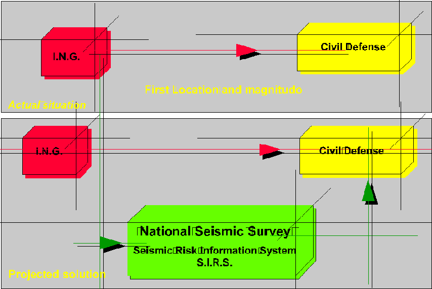
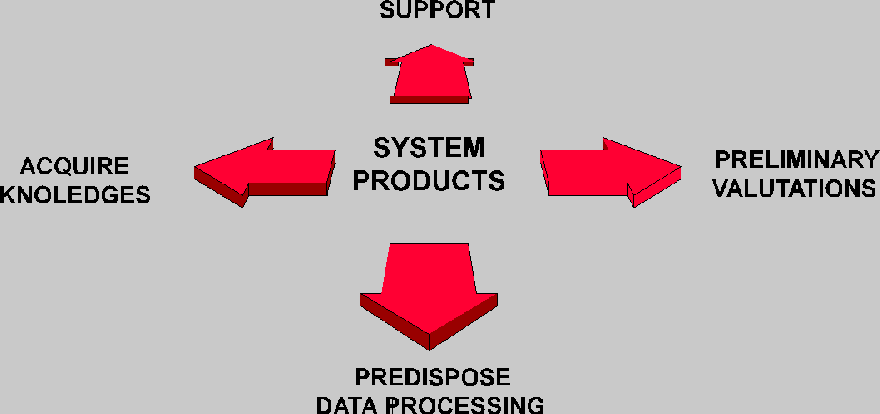
The projected System will complete the actual information (first
localization and intensity) sent by the organization surveying with a
set of information devoted to (see fig.3): support and plan civil
defence interventions; value the damage happened (preliminary
valutations); predispose data processings useful to inform (and to
orient) public opinion; acquire some knoledges useful for prevention in
the future, completing  what is already disposable at the Servizio with
those taken on the place by the same survey and/or by the
administrations, also local, directly interested.
The said work analyses the fundamental elements of the proposed System, underlines

its peculiar characteristics and subdivides it into two guidelines:

Systems integration;

 Operational.


Scenarios and Databases project integration function will be fulfil directly by Servizio

Sismico by means of data acquisition coming from other organizations interested for

competence, and will be bound to collecting standards just made on purpose.


It is forseen, moreover, the integration of the proposed System with everything already

realized and working at the Civil Defence.


2.0    Information system study and design

As it has been already said, there are the following guidelines for the design (see fig.4):


Integration;

Operational.


2.1  Integration guideline

It has been studied and designed the integration between the operational and

surveillance areas of the following structures: Istituto Nazionale di Geofisica - Servizio

Sismico Nazionale - Civil Defence.
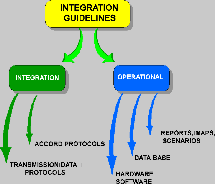
During this systems integration will be very important:

the accord protocols to define the institutional tasks already required and stated by the

law 225/92 (Civil Defence National Service institution);

the data transmissions protocols, and the activation of integrated alarm systems (where

they are not already working), through automatic controls on threshold signals.


Now we have no interest for the accord protocols on the law 225/92: so we put in

evidence better the second point: the transmissions data protocols study and the

automatic control.

Only for the connection: Istituto Nazionale di Geofisica - Servizio Sismico Nazionale -

Civil Defence Department, the block diagram (see fig.5), proposes the information

flow that the whole System must manage, identifying the operational steps as follows:

when a seismic event superior to the first threshold (first threshold or interest

threshold) will occurr, the Servizio Sismico Nazionale will receive (in real time) the

signal transmitted by the Istituto Nazionale di Geofisica
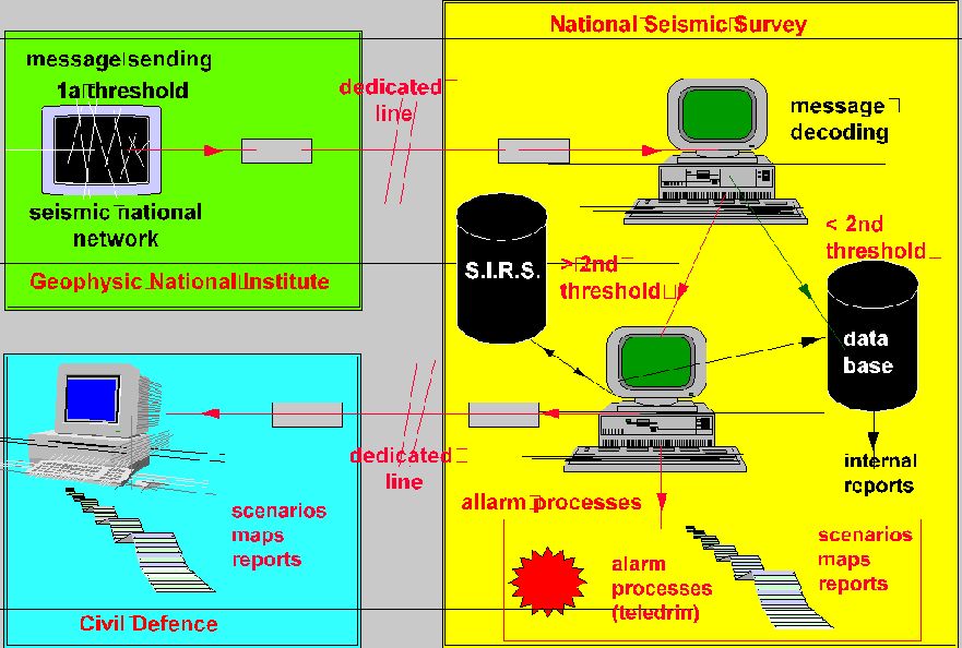
2.1.1 Events signaling
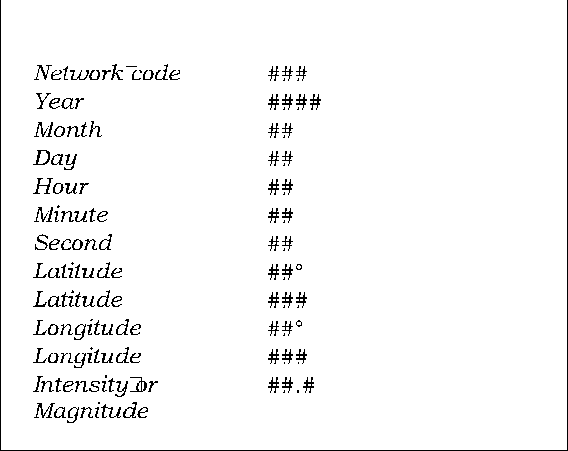
The messages, transmitted in pre-defined protocols (see fig. 6), must contain the
necessary information to define the intensity, the localization and the time of the
event, for every seismic event surveyed and superior to the threshold of interest.
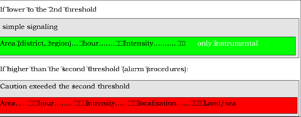
2.1.2 Message decoding
The message decoding will be automated, at the Servizio Sismico Nazionale and will
activate different procedures according with a second pre-defined threshold level
(alarm threshold or second threshold), and respectively:
if lower than the second threshold, filing the event in the data base and producing
internal reports. These events could be related with the data base producted by local
area network active in the interested area and connected in computer network with the
Servizio (simple signaling).
if higher than the second threshold, activating alarm procedures (supposing
automated the Istituto Nazionale di Geofisica - Civil Defence, too), and connection
with S.I.R.S..
In this case the alarm procedures will activate as follows: Event communication by

analogical teledrin systems to Servizio Sismico System.
The pre-defined message (fig.7) will be produced as follows:

integration of the original message received by the surveyor with the operational

information produced automatically by the System:

transmission of this original to the System operators;

activation (in the operational room) of non standard procedures according to the

operational level and alert.


2.2  Operational guideline

The operational guideline identifies in the following points:

final products (reports, maps, dedicated scenarios);

databases;

operational activity.

everything produced an necessary to the System best functionality.


2.2.1	Final products

After the overcoming the second threshold level (automated procedures), it will be

obtained particularly:


table reports (ex.: list of the municipalities involved in the event, with statistical data:

 population, building type, etc,);

base maps (re-proposing in thematic charts the topics already said and/or their

eventual interactions);

operational maps (ex.: road and rail networks accessibility maps, energy transmission

network, infrastructures etc.)

prearrangement (in particular cases) of operational scenarios, using softwares working

out at the Servizio Sismico Nazionale.


As it's easy to realize exactly in the final products we understand the fundamental role

of a dedicated geographical information system.


Besides in the law 225/92, are listed the three intervention phases of the Civil Defence

system:

Prevision, Prevention and Emergency Management, and in these three phases it is

possible to define the roles where a dedicated information system  operate (see fig. 8):
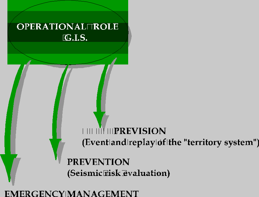
More exactly in the phases of:

Prevision,

with the locating of  scenario coming from a seismic event with a known intensity and

following reply of the "territory system".


Prevention,

where it's fundamental the seismic risk evaluation on national territory. Risk is defined

as the combination of:

Hazard:  physical features of the natural event earthquake;

Vulnerability:  propension of a "good (property)" to suffer damages and/or loss of

functionality after a seismic event;

Exposition: quantity and quality of the properties exposed to seismic risk.


Emergency management,

where is fundamental the reply capacity of the Civil Defence, that must dispose of:

 the information about the said points;

 the distribution of rescue men and means, hospitals structures and/or shelters;

 the least paths (usable) of access to the epicenter area, etc.


For example:

the prevision will be picked up by the Service Data base processing the relation

between event intensity, features intensity and land urbanization and infrastrucures.

This process will individuate the probable damages to the urban systems and

infrastructures stroke by the event.

The prevention will worked by modelling and/or simulation, giving information (in real

time and for the national territory), more detailed such as reports or maps. These

reports or maps must:
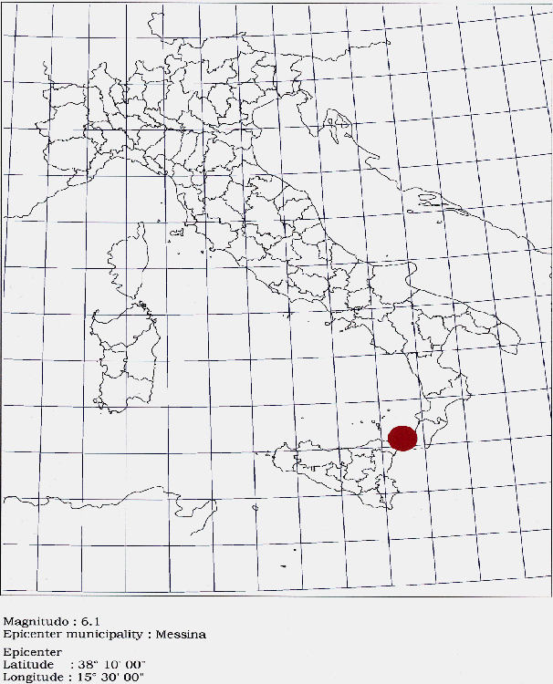
- localize, on the basis of scenarios of the whole territory, the seismic event epicenter
surveyed, making the intensity in evidence by a suitable colour of the chosen symbol
(fig.9);
- define, on the general landscapes basis said above, the interested area (ex. scale
1:250.000), according to the distribution models of earthquake effects also simply
linear;
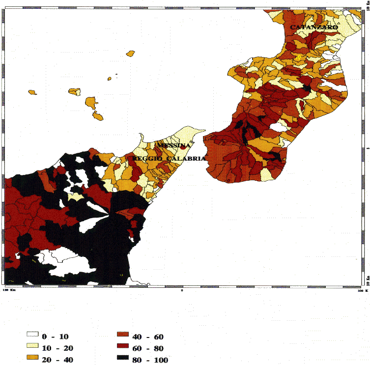
- give the position within the range of xx km from the epicenter (expressed in function
of the earthquake magnitudo or intensity), of structures and services as: percentage of
buildings constructed before national seismic classification, dangerous industries, etc.
(fig. 10 and 11).
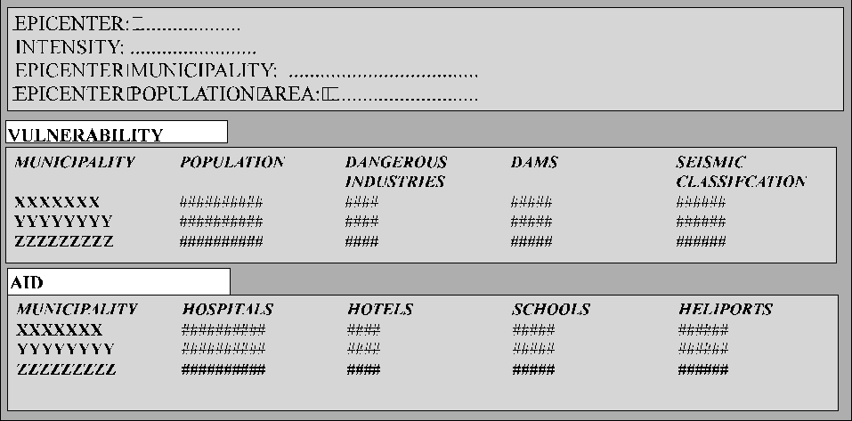
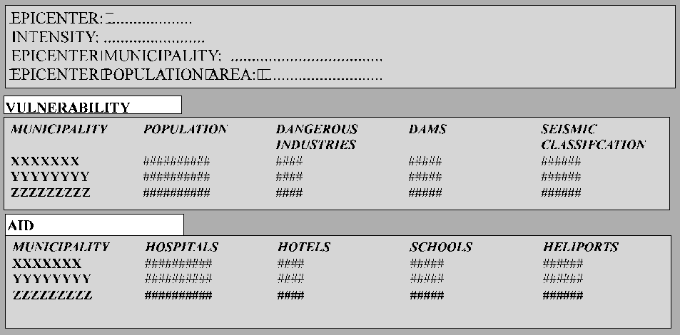
- produce selected reports (fig.12) where, for example,:
Fundamental data appear such as:
epicenter, intensity, epicenter municipality, epicenter area
population:
or vulnerability
interested municipalities, involved population, dangerous industries, dams,
seismic classification, type of buildings;
or aid
interested municipalities, hospitals, clinics, hotels, schools;
or rescues
interested municipalities, heliports, barracks, Civil Defence,
Volunteers Associations.

For Emergency management will be necessary:
- to individuate the accessibilty conditions of the area interested by the earthquake
through the road network (superhighways, highways, main roads, subsidiary roads)
and rail network.
- to simulate, in the case of an interruption of the road and the rail networks introduced
by the operators, the possible accessibility conditions as to the network obstructions;
- to supply the location within the range of 100 km from the epicenter of operational
structures and/or of first use;
- to supply at the right time the informations for the ready intervention staff by
prearranging specific data.
At last, but not the least, the Servizio Sismico Information System database will be
implemented more and more with the purpose to evaluate the whole national territory
vulnerability. To inform correctly and opportunely the public opinion and the
mass-media is optional.
2.2.1 Databases
It is forseen the Seismic Risk Information System (S.I.R.S.) use (integrated with new
databases) for the above said processings production (operational guideline, point 2).
SIRS is defined as a set of data, structured in five subjects ambits such as: Territory,
Buildings, Industries, Services and Infrastructures (see fig.13) .
These data have the following features:
- they are related to administrative municipality areas;
- they have surveying and processing homogeneity;
- they are referred to the whole national territory;
- they have the official character for the surveying institution.
In succession data examples for the five subjects ambits are listed:
for the Territory:
Seismic classification; municipality surface; the chief town altimetry and the
related geographic coordinates; four landslides surveys: Ministry (Department) of
Public Works, Ministry of Agriculture, Movimento Federativo Democratico, National
Geologic Serevice; Demography (year 1991) and variations relative to the last three
census;
for the Buildings:
some variables for the total evaluation of the buildings have been settled; and
also for: the evolution through the time; the verification about the structures and the
adaptation to earthquake-proof; the building concession and the abuse;
for the Industry:
local employees; energy production; dangerous industries (classification by
Ministry of Public Health);
for the Infrastructures:
data on dams, reservoirs;
for the Services:
some data on hospitals; clinics; hotels and schools are present.
Resuming, the set of data contained into SIRS is about 150 indicators (simple and
derived) for 8086 municipalities total (year 1981 as reference), considering also
administrative areas and it is referred to the whole national territory. The cartography
used has been digitized at 1:100.000, with reference to zone 32 and UTM projection.
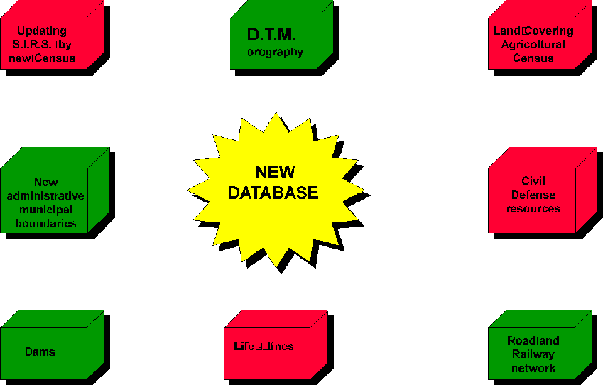
The new databases that will be integrated into SIRS are the following (red flag data
base in progress, green flag data base active - fig. 14):
- alpha numerical data obtained from ISTAT (1991 Census), for updating database
already processed for SIRS;
- cartographic data pertinent to land covering, for the whole national territory, obtained
from 1991 Agricultural Census, ISTAT;
- cartographic data pertinent to centers, and also administrative municipal boundaries
taken for Population Census, 1991, in case updated at cartographic data pertinent to
road and rail network (superhighways, highways, main roads, subsidiary roads);
- cartographic data pertinent to national territory orography, obtained from the database
containing the medium altitude for areas of 250 m (side);
- cartographic data pertinent to dams, obtained from the surveys already available at the
dam Survey;
- cartographic data pertinent to life lines;
- cartographic data pertinent to civil defence resources localization (barracks, deposits
for ready intervention machines special equipments, volunteers associations etc.).
With these database it will be possible to plan scenarios for the whole national territory
and to produce data processing pertinent to:
- every municipality on the national territory;
- urbanized areas classified considering building and demographic density;
- technological networks and connection networks formerly individuated on the
basis of the hierarchical structure.
A detailed analysis will be carried out in the future for regional and local areas with

the following purposes:
- to predispose scenarios, scale 1:100.000, and for main urban areas scale 1:25.000, with
the scope to prepare the documentation for sustaining the ready intervention teams (the
information to public opinion and mass-media is an option);
- to define, to point out and to value more exactly the earthquake features and the
damages caused by the earthquake, integrating the information already available at
the Servizio and the surveys on field, made with the purpose to collect some other
information;
- to extend the risk prevision integrating the Servizio information with those one
available at the regional and local administrations interested.
For this scope, the Servizio and the local Administrations, will standardize the survey
tools on the earthquake damages and effects to integrate the surveying on the field.
2.2.2 Operational system
The System foreseen a hardware and a software (point 3 of the optional guideline) to
grant a continuative monitoring in reception and always working, 24 hours, for 7 days,
for 52 weeks, for year.
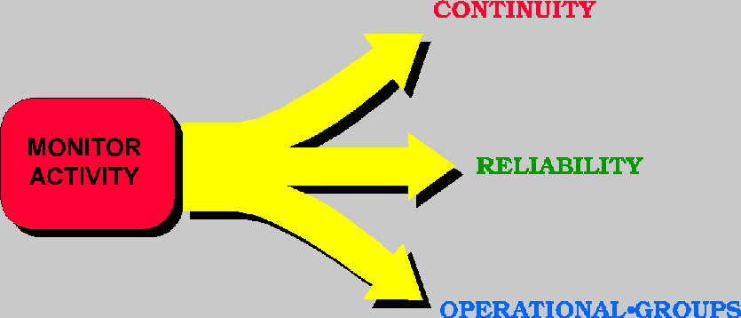
So, the following three points are essential:
- System continuity;
- High reliability computation system or "fault tolerance";
- Constitution of operational groups at the National Seismic Service and at the Civil
Defence Department.
Continuity


Some fundamental elements granting the operational System continuity have been

identify:
- Automatic Systems of support for energy (generators, power units) for the operational
groups;
- Network linkage with the Servizio Sismico information system as support in case of
hard problems of the main system;
- Database continuous updating, integration with the database of the Servizio, utilization
of models and/or scenarios pre-arrangement (external database linkage);
- System defence: accessibility limited to qualified employees.
High reliability Computer System
This is the definition for the hardware that must grant the perfect functionality of the
whole System.
Some products granting the information reception, processing and sending
uninterrupted have been individuated.
The System, integrated with the system already working at Servizio Sismico, is
thought so realized: system conceptually like Disk Mirroring (raid system), that may
use if necessary the structures available on network (computers, database, etc.) at the
Servizio Sismico.
The System so prearranged will grant a remarkable reliability even if the main center
doesn't operate.
As regards the software, at present the Servizio Sismico works with Arc Info and its
modules as Grid, Tin and Network, and on these experience the above said System will
be expanded. The operational procedures, automatized, to produce maps report,
scenarios will be developed directly in AML.
Operational groups settlement (Servizio Sismico Nazionale and Civil Defence)
It is necessary, as third step, to create two operational groups: one group at the Servizio
Sismico, the other group at the Civil Defence. The operational group at the Servizio Sismico,
accessible to qualified employees only, will have to contain the whole instrument
system and the printing and communication systems too, necessary to the work and must
possess autonomous and continuous energy systems. The operational room will be
integrated with everything already existing at the other National Technical Services
(Geological, Dams, Hydrographical), for the purpose to realize a unic support system.
The team working in this center, having the particularity to be activated automatically
when the alarm threshold is get over, might be composed by four persons (normal
gestion): a system responsible, a scenario designer, two system operators.
The terminal point of the System and of the proposed information link, is the
institution of the hot point (with the obvious telematic connessions) at the Civil
Defence operational sector. This sector is the Situations Center, that is the operational
instrument (H24) by which the Civil Defence Department: follows the evolution of the
signalized disaster and coordinates and develops the activities.
The "hot point" institution will be necessarily designed as function of the information
visualization and/or of the scenario useful to the first operational moments after the
event: in this area reports and maps processed by the system will be produced, while at
second time, after the receiving of the first reports directly surveyed in the interested
areas and with the better information, improvements on the quality of the final
products will be activated.
3.0 Phases and time for realization
The System formerly described is very complex, so it needs necessarily a gradual
realization by integrated modules: it could be realized step by step.
At this moment it's possible to forsee the first phase (one year long, at most) will be
developed in the following activities:
- analysis and definition of the System specific techniques;
- individuation and prearrangment of the technologies for the System running
(communications systems, processing automatic alarm, as already said);
- realization of the connection sofware with the network of the Istituto Nazionale di
Geofisica and the Civil Defence, for the transmission of the data regarding the event
at real time and of the software for the event visualization in punctual and symbolic terms;
- realization of the software with the aim to delimit the interested area, by specific
models and algorithms defined by the Servizio Sismico Nazionale;
- acquirement of new database besides those already disposable at the processing
database service;
- system test and inspection;
- analysis and acquisition of the databases regarding the regional ambit selected for
priority;
- prearrangment of the system extension project on a regional ambit selected for priority.
For the second phase, on the basis of the design compiled for the first sample area, the
system will be developed for its functionality pertinent to regional and local scale.
4.0 The costs
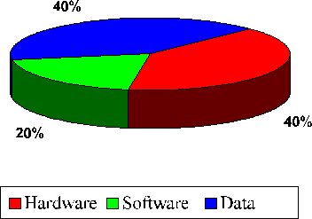
For the activities forseen during the first phase, the expense has been divided
as follows:
- hardware: 500 millions of Lire, to activate communication systems, lines, fees,
computers, printers and all what is forseen by the project;
- software dedicated, with use of the products already tested by the Servizio Sismico
programmed again for this purpose, to acquire and dedicate completely to the project:
200 millions of Lire;
- databases for a total expense of 500 millions of Lire.
This expense is articulated as function of the activities listed at the previous paragraph.
It will be probably lower because there are relations between public structures (e.g.:
ISTAT), but there are also some necessary integrations of data coming from databases not homogeneus.
Conclusions
This paper has treated about a System project (where, the word "system" means the
total of components), dedicated to rescue operations and civil defence intervention
when seismic events occur.
This project studies various operational solutions and sets as goal to integrate
operational reality of Organization and/or Structure working on the territory.
The project for its modularity proposes as referent for similar operations involving the
other National Technical Services.
References
Borrough, P.A. 1986, Principels of Geographical Information Systems for Land
Resources Assessment, Clarendon Press, Oxford
C. Dana Tolmin, 1990, Geographic Information System and Cartografic Modelling,
Prentice Hall Inc., New Jersey
Esri, 1992 ArcInfo Users Guide, Environmental Systems Research Institute,
Redlands California.
Soddu P., Martini M.G., Il Sistema Informativo del Servizio Sismico Nazionale, 4a
Conferenza Nazionale Italiana sui sistemi informativi Territoriali - Firenze 1992, Atti
Caldaretti S., Fabietti W,. Riggio A., 1987, La vulnerabilitŕ sismica dei sistemi
Territoriali, DEI, ed. Roma 1987
Atlante della Classificazione sismica del territorio nazionale, Consiglio Superiore dei
Lavori Pubblici, Servizio Sismico Nazionale, Istituto Poligrafico e Zecca dello Stato,
Roma 1986
Cressie N., Statistics for Spatial Data, 1991 John Wiley & Sons
Dr. Pierluigi Soddu
Dr. M. Giovanna Martini
Servizio Sismico Nazionale (Dipartimento per i Servizi Tecnici
Nazionali - Presidenza del Consiglio dei Ministri -
Via Curtatone, 8 00185 Roma
Tel 39-6-4466878
Fax 39-6-4466940