With the proliferation of GIS capabilities, the complexity level present in each application has tended to increase. While this has put more power into experienced user's hands, the ability to process and extract meaningful data by the less experienced user has been hampered. The Technical Applications Workstation (TAWS) was designed to provide a modular approach to GIS software management. It offers a base set of GIS operations to which additional modules can be added or removed to fulfill particular GIS taskings. These additional modules could be locally- developed applications as well as the integration of commercially- developed products. This allows end users to have only the tools they need for a particular job, reducing the complexity in training and operation. This paper describes the design and implementation used by the TAWS application.
The requirements for a GIS application to be used on a field-deployed portable computer are much different than those of a GIS application residing on a desk top next to a high performance digital scanner. Likewise, a skilled image analyst will want or require different GIS functions than those required by a novice wishing to perform basic selection and viewing functions. Traditionally, this has resulted in the use of separate GIS software solutions for each independent GIS problem or in user-favorite GIS software solutions being utilized regardless of the over all applicability to the requirements present. This approach impedes the quality and speed with which specific jobs can be completed. Also, the associated costs in training and maintaining these separate applications, as well as providing data continuity across disjointed applications is severely affected.
TAWS provides a solution to this problem by allowing a modular, building block methodology. On TAWS distinct GIS functions can be added to or removed from the basic framework. Tailoring of the TAWS functionality to meet mission or user-specific requirements is easily achieved providing a consistent data interface regardless of the complexity of the GIS job. The TAWS application provides a basic set of rudimentary GIS functions and lets a system administrator easily integrate modules according to the task at hand.
The TAWS application is currently UNIX based written using the Environmental Systems Research Institute's (Esri) ArcInfo ARC macro language (AML). Using the ArcInfo GIS toolset with the TIN and GRID extensions allows a great versatility in the number of data formats imported and exported as well as the data manipulations and management possible. Another key factor is the ability to port the resulting product from one operating system to another.
The aim of the software is for integration of product modules that cover specific functionality such as editing or exploitation. Numerous software packages are already present and being used in the workplace. The TAWS effort is not to replace this software but to provide an integrating effect to combine separate software applications towards a common, seamless goal.
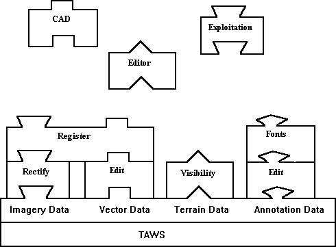
The TAWS application breaks down data into four categories. These categories are comprised of image data, vector data, terrain data, and annotation. Each of these data types are logically placed on a master pull- down menu, allowing the functions that impact that specific data product to be grouped accordingly. Products that impact multiple data types are located on the data type most affected or simply added to each category that could be impacted. Using this scheme, it is easy to quickly configure the software functionality of TAWS to meet specific mission needs.
Image data on TAWS is comprised of any raster derived data. Examples of image data are scanned in maps, satellite imagery, or hand held photography. Sources for imagery data abound including several Defense Mapping Agency (DMA) products such as the Arc Digitized Raster Graphic (ADRG) products, the National Imagery Transfer Format (NITF) 2.0 products, and more traditional imagery products such as the Tagged Image File Format (TIFF) images or the Graphics Interchange Format (GIF) images.
The second category of data on TAWS is vector data. Vector data is comprised of point, line, or polygonal coverages that are spatially oriented. Sources for vector data also are widespread such as the new DMA Vector Product Format (VPF) products and Digital Feature Attribute Data (DFAD) products. Vector data usually requires significantly less storage space than image data and allows querying and attribution.
The third category of data on TAWS is terrain data. Terrain data is comprised of elevation data posts at specified spacing over an area of the world. Sources for terrain data include the DMA Digital Terrain Elevation Data (DTED) products as well as other digital elevation matrix (DEM) products. It is through the inclusion of terrain data that perspective scene generation as well as visibility analysis functions are possible.
The fourth and final category of data on TAWS is annotation data. Annotation data is text positioned over specified points of reference. Annotation is used as a visual aid to assist in the use of one of the other three categories of data utilized by the TAWS application.
The TAWS application utilizes the concept of distinct data sets per region of interest. Each existing data set is characterized by a unique name and is comprised of four types of data (image, vector, terrain, and annotation). Data sets can be viewed as complete GIS products. This centralization of data provides great portability in transporting data from one TAWS application to another as well as provide a centralized location for easy accessibility of data.
To start the TAWS application, a user selects the dataset of interest from those detected on the system. At any time after that, the user has the freedom to switch datasets.
The TAWS application has an application programming interface (API) defined for use with products created using ARC Macro Language (AML) and another one for connection to other types of applications. In both cases, the necessary interface is available in a template that is easily configurable.
For those products built using AML, there is a greater ability to closely couple any additional applications since the TAWS software is also written using AML. There is a defined set of global variables present that are available for use that dictate such items as dataset location on the file system, current data selected by the user for use, and current state of the application. These variables are defined and commented on in the general AML interface template provided with TAWS. To include a new function in TAWS, this template would be copied to the TAWS menu AML directory and uniquely named according to its functionality. In addition, the external call to the new AML code would be added where indicated in the template. The TAWS menu file, in plain text, would have the new menu option added with the call to this file.
For those products not using AML, for example a stand alone binary, the ability to become part of the TAWS architecture is not much more difficult than that stated for AML applications. There is a defined non- AML interface template provided with TAWS. A description of all global AML variables present for use with a command line interface to the new application is included with this template. After copying the non-AML interface template to the TAWS menu AML directory and uniquely naming it according to its functionality, the assembled command line call to the external interface can be inserted. The TAWS menu file, in plain text, would have the new menu option added with the call to this file.
The TAWS application provides routines for the selection and viewing of any image, vector, terrain, or annotation present in a dataset as well as the ability to specify the current working dataset. For image data, any non- registered image can be previewed. Up to eight separate registered and rectified images can be mosaiced at one time. For vector data up to eight separate point, line, and polygon coverages can be mosaiced. The user selects the symbology used for the graphical display of the coverages from a defined set. For terrain data, the user is allowed to dictate a contour interval and line color for each terrain data item chosen. For annotation data, the user is allowed to define which annotation coverages should be drawn and at what scale and color to draw them.
Upon selection of the draw option, all data currently selected for drawing is displayed to the screen in the order of imagery, terrain, vector polygon, vector line, vector point, and concluding with annotation. While in the drawing mode the options of refresh, zoom, identify, query, and fullview are possible. Refresh simply redraws the graphics on the screen from scratch. Zoom allows the portion of the screen specified by the user to define the full screen map extents and will redraw at this new scale. Identify allows the spatial querying of a vector data item and a displaying to the user of all attribution associated with the chosen data item. Querying allows the user to create a vector product attribute search of any vector product currently drawn and display the results. Fullview simply resets the screen spatial coordinates to a bounding box encompassing all data currently selected for drawing.
The ability to generate perspective view scenes over a specified terrain data with the selected image, vector, and annotation draped over the resulting view is also included
As the number and complexity of GIS applications continues to grow, organizations are finding themselves buying and maintaining a greater amount of software. Due to the varied user experiences and knowledge, a suitable software package for one person might be totally inadequate for another. What is needed is a framework that provides a consistent interface and set of tools that can be customized to fit the user and job at hand. The TAWS application provides this. For a mobile application that only requires viewing of data, why encumber the user with other operations that would require significant amount of processing time? For a user versed in a specific application that they are comfortable with, why force them to learn a completely new set of tools to accomplish the same task? Why can't the user be provided with a consistent interface regardless of the task?
The TAWS application allows customization of GIS capabilities to fit task requirements and user experience. Integration of ARC AML, as well as commercial applications, can be done under a consistent user interface to minimize confusion and maximize productivity. The TAWS application provides the means to do business smarter.