Jeff Cargin, John Dwyer
The process for locating a site for Pennsylvania's Low-Level Radioactive Waste Disposal Facility (PALLRWDF) has made extensive use of the Project's Geographic Information System (GIS). All spatial data used in the Project is accessable in some manner through the GIS. Much of the information is processed manually; however, because of the immense size of the project, automation of these processes wherever possible is essential. This paper will discuss several of the special operations that have been performed using the GIS to reduce the level of manual effort required for the project. These operations include: preparation of overlays to reduce duplication of work; automatic disqualification of wetlands; evaluation of road hazards using network applications; evaluation of minimum area requirements for candidate areas; and incorporation of a public values survey. In addition, the paper will discuss the use of the GIS in preparation of displays for the development of an integrated information system for site selection and site characterization.
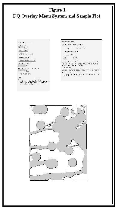
1.0     INTRODUCTION


The process for locating a site for Pennsylvania's Low-Level Radioactive

Waste Disposal Facility (PALLRWDF) has made extensive use of the Project's

Geographic Information System (GIS).  All spatial data used in the Project

is accessible in some manner through the GIS.  Much of the information is

processed manually; however, because of the immense size of the project,

automation of these processes wherever possible is essential.  This paper

will discuss several of the special operations that have been performed

using the GIS to reduce the level of manual effort required for the

project.  These operations include: preparation of overlays to reduce

duplication of work; automating the digitizing process; automated

disqualification of wetlands; evaluation of road hazards using network

applications; evaluation of minimum area requirements for candidate areas;

and incorporation of a public values survey.  In addition, the presentation

will discuss the development of an integrated information system for site

characterization.


 2.0     DISQUALIFICATION


The statewide screening process for locating a site is divided into two

major portions: disqualification and evaluation.  The disqualification

portion of the project identifies features in the state which are not

suitable for the siting of a low-level radioactive waste disposal facility

and eliminates these features from further consideration in the siting

process.  The GIS was used intensively during the disqualification portion

of the project to automate tasks and simplify the process wherever

possible.  The following sections describe some of the time-saving ways in

which the GIS was used, as well as describing some of the more difficult

GIS operations that were attempted and the methods used by the project

team to accomplish them.


2.1     Disqualification (DQ) Overlays


While some of the data collected during Disqualification are represented as

points or lines, the vast majority are area features represented as

polygons.  A key premise of the disqualification process is that once an

area has been disqualified by any given feature, it remains disqualified.

This means that once an area has been disqualified, that area no longer

needs to be investigated for the presence of other disqualifying features

from other criteria.  The GIS is perfectly suited to take advantage of

this component of the project.


Because the GIS has the ability to produce plots at any scale, LAW

developed a technique early in the disqualification process to produce

plots of previously identified disqualified areas which could be overlaid

onto a source map which was being delineated for a new disqualifying

feature. These plots, referred to as DQ Overlays, allowed personnel

delineating new features to determine which areas had already been

identified as disqualified, and therefore did not require delineation for

the new feature.


The most common base maps used for delineation on the project were 1:24,000

scale USGS 7.5-minute topographic quadrangle maps, or other quadrangle

maps that were based on the same 7.5-minute coordinate system.  With

nearly 900 quadrangles across the state, it was necessary to develop a

completely automated method of producing DQ Overlays at the quadrangle

sheet scale to allow for mass production of overlay maps.  A menu based

macro system was developed that allowed the user to simply create an ASCII

file containing a list of the quadrangle numbers to be plotted, select the

desired coverages to be plotted, and execute the plotting program which

creates a map composition, plots the map, and then kills the map

composition automatically for each quad on the list.  The menu system and

a sample DQ overlay are illustrated in Figure 1.
The quad overlay program provides the user with a selection of several

standard coverages, such as the Stage Three Composite Disqualification

Coverage, and will automatically prepare a map of each quad on the list

showing the coverages selected and a standard title block/legend.  Since

most of the standard coverages are stored in a Lambert Conformal Conic

projection, the program also automatically detects the proper state plane

coordinate system zone for the particular quad being plotted and changes

the map projection accordingly as the map is being produced (Pennsylvania

is divided into North and South state plane zones, which are also based on

a Lambert Conformal Conic projection).  The system also allows the user to

specify a user-defined macro, if desired, which will be executed for each

quad map produced.  By using this feature the user has complete

flexibility to use the core features of the quad plotting program, but can

specify any coverages or features to be displayed on the plot, over and

above the standard coverages provided.


To further enhance the effectiveness of the system, a feature was added

which links the input quad lists and the user-defined macros to the user's

name itself.  This allows multiple users to simultaneously use the program

across the network without accidentally changing someone elses setup or

inadvertently over-writing another user's plots.


While quad-scale plots are the most common DQ Overlays produced, the GIS is

often used to produce overlays at a number of different scales, such as

county or municipality scales.  Many times, the exact scale or projection

of the source map cannot be determined, or the source map is not

georeferenced, which makes producing a matching DQ overlay difficult.  To

circumvent this problem, it is often possible to add geographic

references, such as roads, streams or political boundaries, to the DQ

plot.  While not actually used as overlays, these plots aid in helping the

delineators to identify which areas on the source map have been previously

identified as disqualified.


2.2  Automating the Digitizing Process


While the project team attempts to use data that is already available in

digital format whenever possible, the primary means of entering spatial

data into the GIS is manual digitizing.  It is estimated that over 33,000

individual source maps have been digitized to date on the project.  At one

point, nearly 60 digitizers in 13 different offices across the country were

digitizing maps for input into the GIS.  In order to efficiently handle

such large volumes of work, specific procedures were developed, not only

for performing the digitizing work itself, but also for the preparation

and transmittal of maps to and from the digitizing staff.


The process for preparing and transmitting source maps is crucial to

project quality control.  As the delineators complete the identification

of disqualified features, the delineated maps are grouped into a logical

collection of maps referred to as a batch.  Once a group of maps is placed

into a batch, they remain together as a batch for the remainder of the

project.  Each batch is assigned a unique identification number, and a

tracking form is associated with each batch to track its progress through

the digitizing and coverage building process.


Most of the digitizing is performed in AutoCAD.  Over time, a method has

been developed in which the digitizing is performed on a specific layer

for each type of feature being delineated. Feature attributes are added to

the AutoCAD drawing file by the use of block insertions.  By converting

the completed drawings to DXF format and then converting the DXF files to

ArcInfo coverages, the process for converting the digitized files to

coverages is completely automated. Features digitized on different layers

are converted to individual coverages so that multiple coverages can be

produced from one digitized file.  Feature attributes are assigned to the

coverages by converting the attribute block insertion point locations to

label points; the block names themselves are used to assign values to the

attributes in the coverage.  For example, a block named DQ is inserted

into each disqualified polygon digitized in AutoCAD;  the block insertion

point becomes the polygon label point, and the block name is used to

assign a value of "1" to the disqualification attribute in the coverage.


The conversion process from completed AutoCAD digitized files to ArcInfo

coverages is completely automated using AML.  The macro converts the DXF

file to a coverage or coverages as appropriate,  performs the

transformation from digitizer inches to coverage coordinates, adds

attributes from the DXF file, and projects the coverages to the proper map

projection coordinate system.  During the digitizing process, the

digitizers are instructed to overshoot quadrangle boundaries;  the

conversion macro then performs a clipping operation to remove the

overshoots. Finally, the macro joins each map in the batch into a

composite coverage for the batch. Checkplots are performed at each step of

the process to verify that the work has been accomplished according to

stringent project quality assurance standards.


The automation of the digitizing and coverage building process has been one

of the key components of the siting process and has enabled the project

team to efficiently manage extremely large volumes of maps and optimize

utilization of staff resources.


2.3     Wetlands Disqualification


A good example of the use of GIS to automate the siting process is the

disqualification of Exceptional Value (EV) Wetlands.  Under the siting

regulations, a one-half mile buffer area around EV Wetlands is

disqualified.  An EV Wetland is defined as a wetland that is included

within or crosses the boundary of one or more of the following features,

also defined in the siting regulations:

   - Exceptional Value Watersheds

   - National Natural Landmarks

   - National Wilderness Preservation System Lands

   - National Scenic Rivers

   - Pennsylvania Scenic Rivers

   - Areas Disqualified By Surface Water Intakes

   - Areas within One Half Mile of a Threatened or

       Endangered Species Location

   - Pennsylvania Natural and Wild Areas


The source maps used for delineation of EV wetlands were National Wetlands

Inventory (NWI) maps published by the US Department of the Interior, Fish

and Wildlife Service.  These maps are based on 1:24,000 scale USGS

7.5-minute topographic quadrangles.  To manually delineate EV wetlands,

each of the disqualified features listed above were plotted on overlays for

use with the NWI maps;  wetlands included within or crossing the boundary

of any one of the features were then identified and highlighted.  Once the

maps were delineated for each of the individual data layers, they were

manually digitized and processed into GIS coverages.  Once in the GIS, the

wetlands were then buffered by one half mile to define the disqualified

area.  This was an extremely time consuming and costly process to perform

across the entire state.


Fortunately, approximately one-third of the NWI quad maps for the state

were already available from the Fish and Wildlife Service in digital

format (DLG).  In addition, each of the features listed above already

existed as an ArcInfo coverage prepared for other data layers.  To take

advantage of this digital data, an application was developed that combined

each of the disqualification data layers listed above with each

appropriate digital NWI quad coverage to identify the wetlands within or

crossing the feature boundary.  The selected wetlands were then copied to a

separate EV Wetlands coverage.  This process was repeated until each

digital NWI coverage had been evaluated for each of the disqualified

features.  Finally, the selected wetlands were buffered by one-half mile

to define the area disqualified by EV Wetlands.  This process is

illustrated in Figure 2.
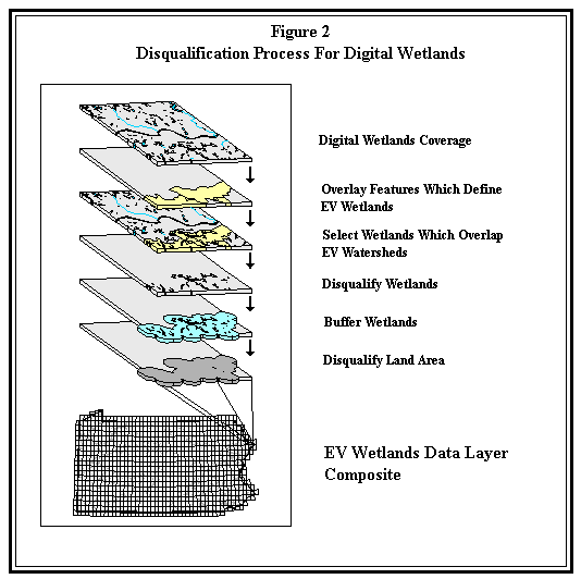
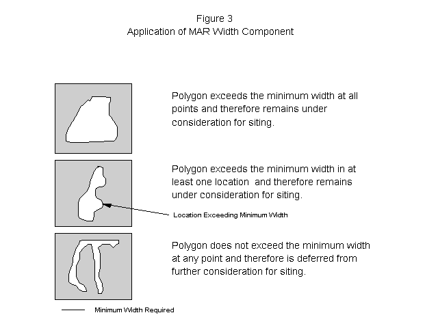
This automated procedure proved to be an extremely efficient and cost

effective method for producing the digital EV Wetlands disqualification

coverage.  The portion of the state available digitally was processed in a

matter of weeks, including extensive quality assurance checks, with a

minimum of staff time involved.  By comparison, the remainder of the state

took several months to complete manually and was extremely labor

intensive.


3.0     EVALUATION


While Disqualification identifies areas which are prohibited from

consideration as potential disposal facility sites, the Evaluation phase

of the project performs a ranking of non-disqualified areas to identify

those areas that are more favorable for siting the facility.  This process,

which is currently being implemented, provides a wide range of

opportunities for innovative GIS applications.  The following sections

discuss some of these applications and the methods in which the GIS is

being used to implement them.


3.1     Minimum Area Requirements


The most intensive effort involved with the implementation of an effective

geographic information system is the initial data entry;  once the system

contains a certain amount of base information, then its usefulness

increases dramatically as various analyses are able to be performed with

the data.  This is also the case with the PALLRWDF project - while the

disqualification data was necessary to eliminate areas from further

consideration, its entry was a tedious and time consuming process.  Now

that the data is present in the GIS, however, the project is reaping the

benefits of this effort during the application of the Evaluation Screening

phase of the project.  One of these benefits is the application of Minimum

Area Requirements (MAR).


Minimum Area Requirements address the fact that the site eventually chosen

to host the facility must meet certain size and shape requirements in

order to satisfy the various design criteria of the disposal modules.

These size and shape requirements are based on the conceptual design of

the facility, and are features that can be readily evaluated using the

GIS.  For example, the regulations state that the size of the facility

should be "approximately 500 acres."  Thus an area may have no

disqualifying features, but if it is only, say, five acres in total size,

it is clearly not large enough to host the facility.  Similarly, a shape

criteria can be established such that a specified minimum width is

required in order for a non-disqualified area to be a valid site.  For

example, assuming a minimum base width of 3,300 feet is established,  a

non-disqualified polygon that is 600 acres in total size would meet the

size criterion, but if it is a long, sinuous polygon that is only 200 feet

wide at its widest point, it would also be unsuitable to host the facility.

Therefore, in order for an area to be considered as a viable potential

site, both the size and shape criteria must be met.


The GIS is extremely well suited to perform this type of evaluation.  The

only requirement that must be met prior to application of MAR is to have a

single, dissolved, composite coverage of all disqualification criteria

(see Section 2.4).  The two MAR criteria are applied separately, and the

areas that do not meet either one or both of the criteria are attributed as

deferred;  therefore, polygons which are not coded as deferred after

application of the criteria meet both minimum area requirements and are

suitable to move forward in the siting process for further evaluation.


At the time of this writing, final MAR size and shape parameters have not

yet been determined. Because the final design of the facility has not been

performed, the GIS is being used to iteratively evaluate various

combinations of minimum areas and widths to perform a sensitivity analysis

to help determine which of the conceptual design models would be most

appropriate to use during the siting process.  For purposes of this paper,

the MAR parameters used in examples will be assumed to be 400 acres as a

minimum size and 3,300 feet as a minimum width.


The application of the size criterion is essentially automatic using the

GIS.  A composite coverage is created containing all disqualification data

layers, and a single polygon attribute is created which indicates whether

a polygon is disqualified or not disqualified.  The coverage is then

dissolved on this attribute, and a new item is added to track polygons

which would be deferred because of MAR.  All non-disqualified polygons

which are less than 400 acres in size are then selected and coded as

deferred.


The application of the width criterion is a more involved process.  The

methodology for applying this criterion utilizes ArcInfo's buffering

capabilities to evaluate the width of a non- disqualified/non-deferred

polygon.  If a polygon must be at least 3,300 feet wide to meet the

requirements, then buffering the polygon internally by 1,650 feet (one half

of the minimum width) will show whether any area remains outside the

buffer area.  If no area remains, then the polygon is not of sufficient

width to host the facility  and the polygon is coded as deferred and is

removed from further consideration.  This concept is illustrated in Figure 3.
The buffering process is a significant effort - on average, each complete
application of MAR takes approximately ten calendar days to run on the
entire statewide coverage after the composite is complete. This time,
however, is extremely short when compared with the amount of time that
would be required to evaluate the areas deferred by MAR for the remaining
Evaluation Screening and Site Selection criteria. The MAR process has
proved to be a significant time and cost saving use of the GIS.
3.2 Road Hazards
One of the criterion statements applied during the Evaluation Screening
phase of the project involves the evaluation of non-disqualified/
non-deferred ("open") areas for the effect of potential road hazards. This
criterion states that an open area is more favorable for siting of the facility
if it is possible to travel from the nearest limited access highway to the open
area without passing through more than four intersections in any one-mile road
segment. This criterion is particularly interesting because of the unique ability
of the GIS to perform the evaluation.
In order to satisfy this criterion, the routes leading from the entrance of
a limited access highway to each open area must be examined. If a route
is found that contains fewer than four intersections per mile, then the
open area is assessed as more favorable. For the purpose of examining
routes, start points and end points are established which correspond to
the first intersection encountered on any road leading out of an open area
and the access point (interchange) to a limited access highway.
Evaluation of this particular criterion posed two critical problems. The
first involved the fact that a "sliding" one-mile segment is used to
evaluate the route from the open area to the limited access highway. In
other words, the route being evaluated could not simply be divided into one
mile segments to count the intersections in each segment. This problem
was overcome by treating the section of roadway between two consecutive
intersections as an independent roadway segment; in order to test for
four intersections per mile, three consecutive road segments (constituting
four intersections) were evaluated. If the three consecutive segments are
less than one mile in length, then that section of road has more than four
intersections per mile and failed the criterion check. This method of
testing lends itself readily to GIS evaluation using a node-link analysis
technique.
The second problem posed with this data layer involves the size of the data
set to be evaluated. The criterion statement states that a potential
access route between the open area and the nearest limited access highway
will be evaluated. This implies that the nearest interchange will be used
as the end point of the route. However, if the nearest interchange fails
the test, this does not automatically make the area less favorable; it
may be possible to find a route to the next nearest interchange.
Therefore, in effect, every possible access point to the limited access
highway system would have to be evaluated until either a viable route has
been found or each interchange has been eliminated. With over 1,500
potential access points to the limited access highway system, this quickly
becomes a monumental task. For example, if it is assumed that there are
approximately 600 areas that have to be evaluated, with each area having,
say, an average of ten roads crossing its boundaries (i.e., ten potential
starting points for each area), then the number of potential start
point/end point combinations that have to be evaluated can reach over nine
million.
An ArcInfo application was developed for applying the road hazards data
layer that addressed both problems to a certain extent. Because of the
limitations of the data sets available, however, no method could be
produced which would completely automate the process. The methods
currently being applied involve a combination of automated processing and
manual verification. The following paragraphs briefly describe the
process that has been implemented.
The program that was written to perform the automated evaluation uses the
Network module of ArcInfo to identify the shortest path route between a
given start point and end point. The program then evaluates each set of
three consecutive road segments along the path to see if they total at
least one mile in length. If so, the program continues along the path with
the next three consecutive road segments. If no combination of three
consecutive segments are less than one mile in total length, then the path
is valid and the area is coded as more favorable. If any three
consecutive segments fail the test, however, the turn from segment two to
segment three is coded as prohibited, and a new path is calculated. Since
the turn is now prohibited, the path-finding routine will find the next
shortest path without passing through the prohibited turn, and the three-
segment test is again performed. The process continues until either a
valid path has been found or all possible paths have been evaluated. Once
all paths for a particular start point/end point combination have been
analyzed, the program moves on to the next potential start point for the
given open area. This process continues until all start points have been
evaluated to the nearest end point; if no path has been found, the
analysis continues again with the original start point and the next
closest end point. Once all start point/end point combinations have been
processed, the evaluation is complete for that particular open area, and
the entire process begins again with the next open area.
Obviously, even using a GIS, this is a time consuming process. Several
techniques have been implemented to try to reduce the number of iterations
necessary. One of these methods is to evaluate each combination of the
first three consecutive road segments emanating from an access point to a
limited access highway (an end point in the evaluation process). If each
combination of the first three consecutive segments from the end point is
less than one mile in length, then there is no way to get to that
particular end point without traveling through four intersections per
mile, and that end point can be permanently eliminated from further
consideration in the path finding process. A similar process can be
executed for start points; if all combinations of the first three
consecutive segments from a start point are less than one mile in length,
then that start point can be eliminated without any further analysis.
The application of this data layer is further complicated by the lack of a
data set which contains the necessary road information. The Pennsylvania
Department of Transportation (PennDOT) has digitized roadways from
1:24,000 scale USGS 7.5-minute topographic quadrangles, which provide a
highly detailed set of base coverages for roads. Unfortunately, the
PennDOT files actually provide too much information in some cases and not
enough in others to be useful for this data layer. The PennDOT files
contain a great deal of graphic detail concerning the road layout across
the state; unfortunately, much of this detail, such as the presence of
wide right turn lanes for example, cause the files to contain multiple
nodes at many intersections. The road hazards application treats each
node in the road file as a separate intersection, and therefore
intersections with such high levels of detail get counted as separate
intersections and cause the intersection per mile evaluation to
incorrectly fail. A similar problem is caused by a lack of overpass
information - a road that crosses another with an overpass will still
have a node present and be counted as a full intersection, even though no
intersection actually exists at that point.
To eliminate some of these problems, the USGS 1:100,000 scale DLG roads
files were selected as the base coverages for this data layer. Because of
the scale of these maps, they do not include quite as much detail as the
PennDOT files, and they include some information on overpasses. No roads
files could be found, however, which included information on turn
restrictions (such as one way streets or ramps, for example). Since it is
not feasible to enter in turn restrictions for the entire state, it was
determined that each successful path found by the GIS would be manually
verified by project personnel to determine if the path is truly valid
(i.e., does not use a route that goes the wrong way on a one way street,
for example).
This data layer provides a good example of how a GIS can be used in a
situation where at first glance it would not appear feasible. In many
cases a GIS application will not provide all the functionality that is
desired, but can still be used to substantially reduce the amount of
manual effort that is involved in a task.
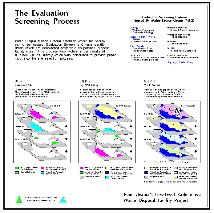
3.3 Public Values Survey (TxP Process)
As stated previously, the Disqualification process identifies areas in
which the disposal facility cannot be placed. The Evaluation Screening
process, however, evaluates each of the non- disqualified areas which meet
the Minimum Area Requirements to assess favorability for another 14
criteria. The 14 evaluation criteria are divided into nine groupings known
as Major Factor Groups (MFG), as shown in Table 1. Three of the groups
have been designated as Key Major Factor Groups - Surface Water Features,
Water Supply, and Geology. The six other MFGs are referred to as
Remaining MFGs. The Key MFGs are composed of criteria related to site
performance objectives, and must be considered more favorable in order for
an area to move forward in the selection process. Therefore, only those
areas that are more favorable for each of the Key MFG criteria are
evaluated for the Remaining MFGs. Any non-disqualified areas which are
determined to be less favorable for any of the Key MFG criteria are
deferred from further consideration.
Each area is assigned a technical score for each of the MFGs: zero if an
area is rated less favorable, and one if the area is rated more
favorable. The public is also involved in the evaluation process. A
public values survey has been used to provide a ranking of each of the
MFGs. The GIS will be used to combine the technical score (T) with the
public rankings (P) to determine an overall rank-sum index score for each
area (TxP). The 50 to 100 highest scoring areas that remain after the TxP
process is performed will move forward to the next phase of the project,
Site Selection.
TABLE 1
Evaluation Screening Criteria
Sorted By Major Factor Group (MFG)
Geology *
-Tectonic Framework
-Carbonate Lithology
Surface Water Features *
- Erosion
- Surface Water Features
Water Supplies *
- Groundwater Table
- Public Water Supply
Land Use
- Federal and State Prison Lands
- Public Gathering Places
Natural Resources
-Mapped Natural Resources
Transportation Effects
- Road Hazards
Weather
- Sever Weather Conditions
Wildlife
- Wildlife Area Boundaries
Cultural Resources
- Protected Area Boundaries
* Key Major Factor Groups
The steps involved in applying the technical scores are essentially the
same as for Disqualification. Coverages are developed which contain areas
that are deemed less favorable for siting a facility. The coverages are
then unioned to create a composite favorability coverage. This coverage
has the effect of carving up non-disqualified areas into smaller polygons
with varying degrees of favorability, ranging from completely favorable
(the polygon is more favorable for all nine MFGs), to less favorable for
all six of the Remaining MFGs, (any areas that were considered less
favorable for any one of the Key MFG criteria will have already been
deferred from further consideration).
Once the technical evaluation coverages are complete, the public rankings
are then applied. The rankings were determined by the use of a Public
Values Survey conducted by an independent consultant. The survey asked
members of the public to rank each of the nine MFGs in order of
importance. The surveys have been performed by DER region to provide
regionalized rankings. This allows the project team to take into account
the fact that different areas of the state may consider the relative
importance of the MFGs differently. For example, the rankings that come
out of a highly urbanized region such as Region 1 (South East -
Philadelphia area) may be substantially different than those that come
from a predominantly rural region such as Region 4 (North Central
Pennsylvania). As of this writing, the results of the Public Values Survey
have not been made available to the technical staff developing the
favorability coverages, to avoid any bias, or appearance of bias in the
coverage development process.
The process of combining the technical scores with the public rankings is
illustrated in Figure 4. For each polygon, the technical score for each
MFG is multiplied by the appropriate public ranking to determine an
overall score for the polygon. Once this is complete, a threshold score is
selected, and the number of polygons with that score is determined, with
the goal being the selection of 50 to 100 polygons to move to the next
phase. For example, the lowest possible score (more favorable for all six
Key MFG criteria and less favorable for the eight Remaining MFG criteria)
is 6; therefore, the initial threshold score is set to 6. If there are
only 50 to 100 polygons with a score of 6, they would be moved into Site
Selection. However, if there are more than 100 polygons scoring 6, then
the threshold score is set to 7, and the number of polygons scoring either
6 or 7 is determined. Each polygon selected is also evaluated for Minimum
Area Requirements (see Section 3.1) to be sure that the polygons moving
forward are of sufficient size and shape to support the facility. This
iterative process continues until a threshold score is found which will
produce approximately 50 to 100 viable areas for Site Selection.
4.0     SITE SELECTION AND CHARACTERIZATION


The Site Selection process will select three candidate sites from the pool

of 50 to 100 areas.  These sites, along with three alternates, will be

submitted to the Environmental Quality Board (EQB) for approval.  Upon

successful review and approval by the EQB, a detailed characterization of

each of the three sites will be conducted to identify the one most

suitable for licensing.


During the Site Selection process, preliminary application of a process

similar to that of Evaluation Screening will be used to reduce the 50-100

areas to a smaller subset.  Detailed studies, based on publicly available

information, will then be performed on this subset, from which three

potentially suitable sites will be selected for characterization.  During

the characterization process, access is gained to the sites, and detailed

surface and subsurface geological and hydrological investigations are

performed, along with such activities as air and water quality monitoring

and flora/fauna surveys.


The earlier portions of the siting process, Disqualification and Evaluation

Screening, were essentially binary processes; an area was either

disqualified or not; or it was more favorable or less favorable.  While

some of the processes associated with these decisions could be rather

complex, the databases associated with them were simple, involving mainly

feature identification.  In contrast, the latter portion of the Site

Selection process, and the Characterization process, are database

intensive, and the interplay of the databases in analysis and modeling

takes center stage. While no Site Selection of Characterization activities

have yet been performed in Pennsylvania, planning for the implementation

of these phases has begun, and a prototype site information application

has been developed to demonstrate the usefulness of the GIS in these

activities.


While the details of the Site Selection process are still being developed,

in general the first portion of the process involves the application of

certain evaluative criteria as more or less favorable, in a manner similar

to that of Evaluation Screening, to narrow the subset of available areas.

This portion of the process will also be handled in the GIS in a manner

similar to that of Evaluation Screening.  The subsequent portion of the

process involves a more intensive data gathering and compilation for the

remaining areas for use by a Site Selection Panel, which then selects

three potentially suitable sites from among the candidate areas.  In order

for the Site Selection Panel to make best use of the necessary data (which

includes information on geology, hydrogeology, hydrology, flora and fauna,

local zoning, property ownership, and much more), an ArcView interface

will be developed.  Based on the prototype site information application,

the interface will allow examination of inter-related data sets for a

given site, as well as allowing site-to-site comparisons.


Once the three potentially suitable sites have been approved by the

Environmental Quality Board, the Characterization process can begin.  The

Characterization Plan is not yet written; however, as currently

envisioned, the Characterization effort will be coordinated out of a

central office, and each of the three sites will be equipped with a local

field office which will perform the data collection for the site. Wherever

possible, data will be collected in the field in a format that can be

readily input into the relational database system maintained within the

GIS.  This will include the use of Global Positioning Systems (GPS), as

well as automated data collectors for such activities as air quality

monitoring.  In addition, each of the field offices will be equipped with

a CAD station and digitizing tablet to assist in the conversion of field

data to graphical files.


Each of the field offices will be connected via a wide area network to the

central project office. This is where most of the concentrated GIS effort

will be performed, including base coverage and database development, as

well as analysis and modeling.  The field offices will also be equipped

with ArcView stations, so that the engineers, geologists, and scientists on

site will have immediate access to the data in the central GIS database,

as well as the results of the analysis and modeling to assist them in

making interpretations of the data and decisions as to future activities.


ACKNOWLEDGEMENT


The authors wish to acknowledge the management and staff of Chem-Nuclear

Systems, Inc., for their cooperation and support in the production of this

paper, and throughout the entire GIS siting effort.