Joao Ribeiro da Costa, M. Lacerda, H.B. Jesus
The Portuguese Water Resources Information System: using OOP to
integrate time series and GIS
ABSTRACT
The Portuguese Water Resources Information System, SNIRH, is owned and
operated by the Portuguese Water Institute, INAG. It stores data on
climate, hydrology, ground-water and water uses, originating on over
1200 measurement stations in the country, as well as from the
day-to-day management tasks of the Institute. Besides being the archive
of water resources data collected in Portugal the system was designed
aiming at providing the data analysis capabilities required to support
hydrological studies and the development of water resources plans.
SNIRH's first version was developed in 1990, based on a relational
model develped by LNEC and UNINOVA. In 1994 it was decided to do a
major upgrade, in order to implement a client server version, capable
of handling requests from many different users, in a network
environment. ORACLE was selected as the data base management system
underlying this new version.
Most data stored at SNIRH originates from field measurements, ranging
from rainfall and temperature to water levels and water quality.
Sampling is both continuous, like in gauging stations, and discrete,
like daily rainfall. As it is widely recognized the relational model is
quite limited in terms of dealing with this type of data. After a
number of tests it was decided to use an Object Oriented Approach to
the problem: a time-series object, TSO, was developed which is capable
of storing all sorts of time series generated in SNIRH, as well as
performing the required operations. A new fully Object Oriented
Language, Sather, was selected for the development. The time series are
stored in ORACLE using a Binary Large Object approach, the final result
being a quite efficient system. The final result is a Time Series
Server, TSServer, which has its own Browsing window and display window.
This TSServer can work either isolated or in combination with
ArcView2.
In order to fulfill the needs of the various types of studies SNIRH
must integrate data other than the measurements performed by INAG,
namely geographic data, like elevation data (DTM, slopes, aspect),
hydrographic data (rivers, drainage basins, aquifers), water uses data
(wells, dams, pipelines) or even administrative data which is used as a
framework for analysis. In addition hydrological studies rely on the
combination of time-series data and geographic data. Besides the basic
needs of locating measurement stations these studies imply almost
always the extrapolation of data measured in the measurement stations
to larger areas. Traditional methods like Thiessen Polygons of
isolines tend to be replaced by more powerful methods based on
krigging.
Integration of time-series with GIS was one of the great challenges of
the new version of SNIRH. ARCView2 was selected as the GIS interface,
given its versatility and excelent interface, which greatly facilitates
integration of new developments. A General Use Interface of SNIRH was
developed based on ArcView2, which allows displaying the base maps,
interactively querying SNIRH, selecting the data for analysis, for
instance average rainfall in a 50 year period in 60 different rain
gages in a given area of interest, and processing the data, for
instance compute a rain surface using krigging and displaying the
results as isolines.
The paper presents the time series object in detail, discusses the
ORACLE implementation and the integration of this system with ARCView2,
illustrating with on-going applications in Portugal.
Time Series, OOP, water resources, hydrology, ARCView2, ORACLE, Sather,
Information System
SNIRH
The law underlying the creation of the Portuguese Water Resources
Institute, INAG, establishes as one of its responsibilities the
creation and maintenance of a Water Resources Information System,
capable of providing the data and Information required for water
resources management. In fact collecting hydrological data and
publishing it has been the responsibility of INAG' s ancestors since
the beginning of the century.
The first attempt to move from a file based system to an organized
database was done in 1990, with the prototype version of SNIRH, the
Water Resources Information System (Costa et al 1990). After the
re-organization of the Institute the project was resumed, and it was
decided to move from the prototype stage to a fully working Information
system, capable of handling requests from many different users, in a
network environment.
The Portuguese Water Resources Information System, SNIRH, starts in the
field, collecting data on climate, hydrology and ground-water in over
1200 measurement stations in the country, and gathering data from
day-to-day management tasks of the Institute. In a second stage SNIRH
processes and stores those data in a complex database system. In a
final stage SNIRH makes those data available to the Institute as a
whole and to the outside world, providing the data analysis
capabilities required to support hydrological studies and the
development of water resources plans.
Thematic structure
The foundations of SNIRH are INAG' s own sources of data, either field
measurements (ranging from rainfall and temperature to water levels and
water quality) or its management tasks (such as issuing groundwater
permits or emission licenses). However, as the ultimate goal of SNIRH
is to act as a decision support system for water resources planning, it
must integrate other types of data.
Past experience with the development of the Ave River Water Resources
Management Plan (Costa et al 1988) and the more recent Guadiana
Information System (Costa et al 1994, 1995) were the basis for the
definition of the thematic structure proposed for SNIRH. This structure
comprises INAG' s data on climate, surface waters, groundwater, water
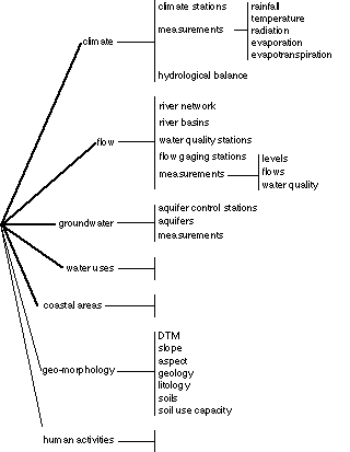
uses and coastal areas, see Figure 1, and support data, namely
geomorphologic data and administrative data.
Climatic, surface waters and groundwater data originate mostly on
measurements carried out on fixed points in space: the measurement or
sampling stations. The results of measurements are time-series of
continuous or discrete values, which constitute the bulk of the data
stored in SNIRH. These time-series have to be processed and combined
with other data to provide the Information required for water resources
planning.
General structure
Functional analysis
With the creation of the new version of SNIRH, INAG is reorganizing its
activities around the system, using it to help with most daily tasks,
rather than just doing the same old tasks using the computer instead of
the hand calculator or spread-sheet. This rather ambitious goal
implied a complete review of the functional analysis carried out for
the development of the prototype of SNIRH developed in 1990, namely
to:
i) identify and assign priorities to the tasks INAG must perform;
ii) define procedures to carry out those tasks.
The result of this process was a document, describing the system in
detail, listing the main procedures and specifying the main
implementation steps (INAG 1995).
Database server
Given the multiple tasks to be carried out by SNIRH it was fundamental
to isolate the database storage and maintenance tasks from the data
processing ones.
On the other hand given SNIRH's complexity, an open modular approach
was necessary to integrate the long term goals with the need to support
urgent tasks in the short term.
In order to fulfill these requirements, SNIRH was designed as a
database server, continuously receiving data from many different
sources, and simultaneously replying to requests from many different
clients, see Figure 2.
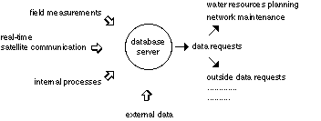
INAG selected ORACLE as the database server; the system is installed in
a network including workstations and PC's, both at the Institute and in
the 5 regions around the country. The database server concept was taken
as far as possible, storing at the central database not only the usual
data, mostly time-series and alphanumeric, but also complex data, like
images. ORACLE's Binary Large Object, BLOb, was used to support this
implementation. The only data that so far are not included in the main
server are maps. ArcInfo's ArcSTORM is being tested to extend the
database server to the maps as well.
Interfaces
A database server is accessed through client programs. As the database
server is independent of the clients, at least theoretically many
different clients can be added. However to preserve the consistency of
the system it is crucial to keep it as simple as possible. So the
multiple tasks to be supported by SNIRH were analyzed in order to
identify the interfaces needed.
It was concluded that three different interfaces were sufficient to
satisfy all requirements:
- a SQL command line interface, for low level system administration
tasks, ORACLE SQLPlus;
- a General Purpose Interface, used for the measurement network
management, database update, and to produce regular data reports;
- a Water Resources Analysis Interface, used to support most studies.
After a number of tests it was concluded that Microsoft ACCESS gives
all the capabilities required to develop the General Purpose Interface.
ARCView2 was selected as the GIS interface, given its versatility and
excellent interface, which greatly facilitates integration of new
developments.
A set of guidelines for interface development were defined, which
clearly specify the rules that must be complied with in the development
of any SNIRH interface, ranging from attribute organization in forms,
to colors and types of fields. This approach enabled various teams to
work simultaneously, obtaining final results which are SNIRH-like.
Procedures
However, the ultimate goal of SNIRH is improving the technical
performance of INAG. Past experience has demonstrated (Costa 1995) that
delivering good tools and good training is not enough to insure better
institutional performance. Two types of problems emerge:
i) professionals once trained leave the institute, and once they leave
it is necessary to repeat all the training;
ii) computer based tools are quite successful at stimulating the
imagination, with two different results: the final product depends on
the person doing it; and it may take for ever to produce a practical
result.
In order to avoid both hindrances it is necessary to define working
procedures, which specify clearly how each task should be completed,
using SNIRH as the basic tool. The degree of integration of the
procedure into SNIRH depends on its complexity. For simple cases, like
computing the rainfall over a given hydrographic basin, it may be
totally built into SNIRH; for more complex cases, like validating
rainfall stations, the validation steps can be built into SNIRH but
expert intervention is always required.
Precise procedure definition becomes an important tool also in terms of
staff training, and even for the outside world, as consulting companies
get precise rules to comply with, rather than having to re-invent the
wheel at high cost each time a new contract is issued. Part of the
SNIRH development program includes HTML based procedure documentation,
which may be consulted through the system.
The Time Series Object
As previously said, the bulk of the data stored at SNIRH originates
from measurements carried out in the climatic and hydrographic
networks. Examples are rainfall, temperature, evaporation, water level,
Dissolved Oxygen, etc. At present there are about 1200 measurement and
sampling stations in the country.
Some of these measurements are discrete, like daily rainfall or 9 a.m.
temperature. These measurements can be represented as:
[(x1, t1), (x2, t2), ..., (xn, tn)]
Because these are measurements at discrete times, nothing can be said
about x at time ti < tl < tk.. Other measurements are continuous,
like water level in a gagging station. These measurements can be
represented the same way; however, in order to know x at time tl, such
that ti < tl < tk , it is enough to do an interpolation between
the two values. Needless to say that in general the sampling interval
is not regular:
(t1 - t2) (t2 - t3) (ti - ti+1)
Once having the water level measured and stored as a continuous
measurement it is possible to transform it into a time-series at
regular intervals, with any sampling interval compatible with the
measurement device being used. It is widely recognized the relational
model is quite limited in terms of dealing with this type of data.
Since the first tests in 1990 it was decided to adopt an Object
Oriented Approach to the problem (Lemos et al 1989). A first version of
a time-series object, TSO, was developed using C programming language,
and the SNIRH prototype was developed using extensively this object.
The whole formulation was revised for the new version of SNIRH, now
using a fully Object Oriented Language, Sather. The time-series is
treated as one more data type within ORACLE, and stored as a BLOb.
Besides its data structure the TSO has built in methods to deal with
time- series analysis, ranging from simple time integration methods to
more sophisticated time-series analysis like filtering or smoothing.
The Water Resources Analysis Interface
The Water Resources Interface, WRI, was designed to be the day-to-day
tool for hydrologic and water resources studies, ranging from resource
availability analysis, to impact analysis. For instance in a first step
it must allow the display of the base maps, interactively querying
SNIRH, selecting the data for analysis, etc; in a second step it must
allow a time-series analysis, for instance computing rainfall
characteristics for a 50 year period in 60 different rain gauges in a
given area; finally it must extend the results to the whole area,
computing the rain surface using krigging and displaying the results as
isolines. In short it must combine the GIS capability of presenting and
handling maps, with the capability of manipulating time-series and
extending point measurements to area results.
As it is widely recognized traditional GIS systems are not suited to
deal with time varying data, and integration of time in GIS is a
current area of debate (Raper 1995), so the integration of time-series
with GIS was one of the great challenges of the Water Resources
Interface. The solution implemented tackles only the case of point
measurements, although it is believed that the same Principles will
apply to area measurements (like for instance remote sensing).
Existing alternatives for this interface can be clustered into two groups:
- creating a unique interface, where maps, plots and text are merged,
along the lines defined by Fedra (1993), (Loucks, Costa 1991);
- using existing GIS and database software, extending it to handle the
specific tasks of time-series analysis.
A prototype XWindows interface was developed in 1991; a second
prototype was developed in 1994 combining a Motif Control Panel and
integrating GRASS as the GIS engine. A thorough analysis of the results
and the man-power required to move from a prototype stage to a fully
reliable system clearly indicated that it was not possible or worth to
compete with extremely refined mapping applications like ArcView2. So
it was decided that rather than creating a new application it was more
effective to concentrate on specific add-ons.
The solution implemented is based on three principles:
i) time-series are autonomous, so they may be analyzed independently of
any GIS interface;
ii) time-series are measurements carried out at given points in space,
so they may be analyzed within a geographical context;
iii) measurement stations yield values of a complex surface of the
phenomena under analysis, it must be possible to extrapolate this
surface, based on the single point values, using appropriate surface
estimation methods, ranging from Voronoi Thessalation to Krigging.
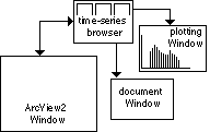
In practice the WRI is a combination of a Time-Series Analysis
application with ArcView2, see Figure 3. The Time-Series application
has 3 main windows:
- the Time-Series browser, lists all the time-series available for the
set of measurement stations selected (directly of through ArcView2),
for the period under analysis;
- the Plotting Window allows plotting any combination of time-series, as
well as doing time-series operations on them (for instance changing
sampling interval, smoothing, etc.);
- the Document Window allows displaying values and help messages. It
may be used independently from ArcView2, or in conjunction with it.
Typically the user starts with the analysis of the location of the
measurement stations in ArcView2, using general browsing tools and
specific procedures already develop, selects the area of interest and
pushes the time-series button. The time-series browser is displayed,
and the set of measurement stations selected in ArcView2 is displayed,
as well as all the time-series available in SNIRH for the period under
analysis.
In a second stage of time-series processing the user may work in the
time-series windows alone. When the final results for the measurement
stations are obtained it may be necessary to extrapolate them to the
whole area. ArcInfo is used as a map processing server and the final
results displayed in ArcView2.
Future and Conclusions
SNIRH is operational and most hydrologic data available at INAG is stored and
easily accessible. As any live information system SNIRH is never finished: new
areas are being added as well as new processing capabilities. The following
developments are planned for the next two years:
- extending the time-series analysis package to handle water quality
analysis;
- extending the whole system to handle coastal area analysis and
integrate the results from Coastal Area Management Plans being carried
out;
- integrate simulation models as analysis tools, namely to simulate
water quantity and quality in a river network.
References
COSTA, J.R. et al. 1988 - Metodolgias para a Avaliao de Politicas de Recursos Hdricos- Plano de Gest‹o dos Recursos H’dricos da Bacia do Rio Ave.
(Methodologies for Water Resources Policy Analysis - The Ave River
Management Plan). Laborat—rio Nacional de Engenharia Civil, Lisboa, 1988.
COSTA, J.R. et al. 1988 - Metodolgias para a Avaliao de Politicas de
Recursos Hdricos- Plano de Gesto dos Recursos Hdricos da Bacia do Rio
Ave. (Methodologies for Water Resources Policy Analysis - The Ave River
Management Plan). Laboratrio Nacional de Engenharia Civil, Lisboa,
1988.
Costa, J.R., Cunha, L.A., Santos, M.A., Loureiro, J.M., Santos, J.B.,
Maio, C.R., Neves, J.R., Gomes, A.C. 1990 - Sistema Nacional de
Informao sobre.
Recursos Hdricos - SNIRH, definio e estruturao. Relatrio UNINOVA/DGRN.
Costa, J.R., Jesus, H.B., Fonseca, V. 1994 - The role of GIS in
environmental planning: the Guadiana case
Costa, J.R., Jesus, H.B.,
Fonseca, V., Seabra, C. 1994 - COVEPLAM: A GIS based methodology for
water quality management in Mediterranean Areas. Comunicao ao EGIS
Conference, Paris 1995. 10 pp.
Costa, J.R. 1995 - An outsider in decision making: implementation of
GIS in complex environments. Keynote paper EGIS conference the Hague,
March 1995.
Fedra, K. 1993 - GIS and environmental modeling. In Environmental
Modelling with GIS, Ed. by Goodchild, M.; Parks, B.; Steyaert, L.
Oxford University Press, 1993.
INAG 1995 - SNIRH: the Water Resources Information System. INAG,
Portugal. Lemos, L.; Violante, A.; Costa, J.C.; Ford, D.; Oliveira, R.
1989 - A time-Series Object for Water Resources Information Systems.
Lisbon, Portugal, UNINOVA-GAS.
Loucks, Costa 1991 - Decision Support Systems: water resources
planning. Springer-Verlag.
Keywords
Time Series, OOP, water resources,
hydrology, ARCView2, ORACLE, Sather, Information System.
Author Information
Joao Ribeiro da Costa, Professor
New University of Lisbon
Quinta da Torre
Monte de Caparica 2825, Portugal
Email: jrc@uninova.pt
Fax: 351- 1- 2957786
M. Lacerda
INAG
National Water Institute
Av. Gago Coutinho
Lisboa 1000, Portugal
H.B. Jesus
UNINOVA
Quinta da Torre
Monte de Caparica 2825, Portugal
Email: hbj@uninova.pt