Bruce Carroll, Vaughan Landrum, and Lisa Pious
ABSTRACT
FORPLAN is used by the Forest Service and private industry to schedule the management of forestland over time. However, FORPLAN is non- spatial and cannot model Oregon, Washington and California regulations that constrain timber harvesting based on whether adjacent stands have been recently harvested. Therefore, FORPLAN may produce solutions that cannot be implemented in the field. To resolve this problem, Boise Cascade Corporation retained Pacific Meridian Resources to link ArcInfo with FORPLAN to produce an application (the Spatial Feasibility Test, or SFT) that tests the feasibility of FORPLAN solutions against adjacency constraints. SFT applies a FORPLAN solution to a coverage of timber stands (up to 100,000 polygons have been tested). The user specifies a maximum adjoining size for any set of silvicultural treatments (e.g. maximum of 120 acres for clearcuts) in any period. SFT can also apply a regulation in which stands that are adjoining for less than a given percent (e.g. ten percent in Washington) of their perimeter are not considered adjacent. SFT produces reports and coverages that itemize how well SFT was able to apply the FORPLAN solution to the ground. Boise Cascade will use SFT in an iterative manner: Run FORPLAN; run SFT to apply adjacency constraints; re-formulate FORPLAN to more closely match SFT outputs; re-run FORPLAN and SFT; and continue until SFT is able to fully allocate the FORPLAN solution. The resulting FORPLAN solution will then be implementable under adjacency constraints.FORPLAN
FORPLAN is a matrix-generator for linear programming that is specifically designed for management of large areas of forestland. FORPLAN accepts tabular information on the landbase (i.e. acres of each stand type), potential silvicultural and management prescriptions for each stand type, revenue and cost streams associated with each prescription, and any number of constraints on the landbase (e.g. harvest levels must be non-declining over time). FORPLAN then submits the matrix to a linear program that attempts to maximize an objective (e.g. maximize lumber production) subject to the given constraints. The result is a FORPLAN allocation of the prescriptions that must be applied to a given acreage of each stand type in each time period to produce the maximum objective. The US Forest Service originally developed FORPLAN to help each National Forest develop Management Plans as required by law. Boise Cascade Corporation uses a customized version of FORPLAN on its corporate timberlands to predict the potential benefits of management.ADJACENCY CONSTRAINTS
The primary drawback to FORPLAN is that it is non-spatial. There is no guarantee that a FORPLAN solution will be implementable, since FORPLAN cannot analyze site-specific cases such as seasonal inaccessiblity or logging practicalities. When adjacency constraints are in effect, as they are in Washington, Oregon and California, FORPLAN alone may vastly overestimate the potential benefits of management. A typical regulation is: Oregon: Maximum clearcut size of 120 acres, 4 year lag between adjoining harvests. This implies the following adjacency constraint: The combined area of adjoining polygons allocated to the clearcut prescription must not exceed 120 acres in any 4 year span. Because of this adjacency constraint, there may be no way to distribute harvests across the landbase and meet the FORPLAN allocation while complying with the adjacency constraint.SPATIAL FEASIBILITY TEST
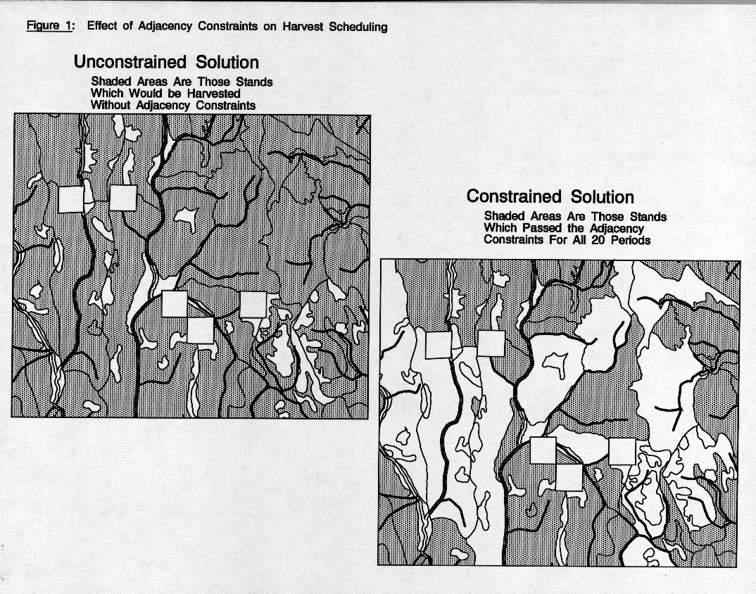
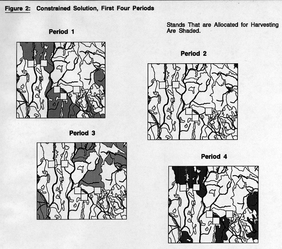
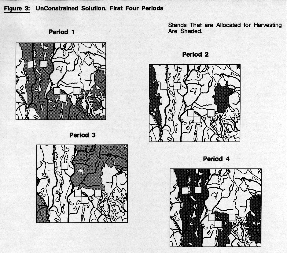
To solve this problem, Boise Cascade retained Pacific Meridian Resources to produce SFT, the Spatial Feasibility Test. SFT is an ArcInfo based application that attempts to "disaggregate" a FORPLAN solution by applying it to an actual coverage of stand polygons. SFT can apply adjacency constraints to any silvicultural treatment code (such as clearcut) that the user specifies, with an associated maximum acreage (such as 120). SFT is not an optimizer. It progresses through the list of stand polygons, and attempts to allocate the current polygon according to the FORPLAN solution. SFT checks the polygon's neighbors for adjacency violations for all time periods (e.g., there may be 20 5-year periods, for a simulation total of 100 years). If none are found, the polygon is assigned the prescription specified by FORPLAN, and SFT moves to the next polygon. This method is deterministic, based solely on the order in which the polygons are checked. To counter this weakness, SFT allows the user to re-sort the polygon list on any database item, including a random number, and submit numerous runs to SFT for the same adjacency constraints. SFT automatically compares the set of runs, and ranks them according to a user-specified criteria. The user can then apply the result of a chosen run to the original stand coverage, and produce maps and analyses using standard ArcInfo and ArcView. Figures 1 through 3 demonstrate SFT output. Figure 1 shows the effect of adjacency constraints on harvest scheduling. Shaded areas are scheduled for harvest at some time in the 20 period run. Unshaded areas are never harvested. The unconstrained solution meets the FORPLAN allocation for the area. The constrained solution falls far short of the FORPLAN goal. Figures 2 and 3 show the harvest pattern chosen by SFT for the first 4 periods.
ITERATIVE NATURE OF ANALYSIS
Boise Cascade is using SFT with FORPLAN in an iterative cycle.
FORPLAN is run first, then numerous SFT runs are performed, using
applicable adjacency constraints.  If SFT is able to allocate the full
FORPLAN solution, no further cycling is needed, since SFT has proven
that the FORPLAN solution is attainable given current adjacency
constraints.

If SFT cannot allocate the full FORPLAN run, then FORPLAN will be
rerun with tighter constraints.  For example, if the best SFT run was able
to allocate only 75% of the FORPLAN solution, then FORPLAN may be
rerun with an objective that is 75% of the previous FORPLAN run.  SFT is
then run on the FORPLAN output, and the iterative cycle continues.
When SFT is able to allocate the entire FORPLAN solution, then Boise
Cascade is assured that the FORPLAN goals are attainable.

SFT is not intended to be an intelligent harvest scheduler, as it does not
create a logical harvesting pattern across the landscape based on
transportation networks or working circles.  SFT's main purpose is to test
the feasibility of Boise Cascade Corporation's FORPLAN runs under
adjacency constraints.  With SFT, Boise Cascade Corporation will use
FORPLAN with increased confidence that FORPLAN's results are
realistic and implementable.  SFT is currently being enhanced to include
such features as multiple adjacency constraints operating simultaneously,
and the ability to allocate FORPLAN runs on a yearly basis.
Vaughan Landrum, Vice President
Pacific Meridian Resources
5915-B, Hollis St.
Emeryville, CA 94608
Tel: (510)654-6980
Fax: (510)654-5774
E-mail: pmr@crl.com
Lisa Pious, Senior Programmer
Pacific Meridian Resources
5915-B, Hollis St.
Emeryville, CA 94608
Tel: (510)654-6980
Fax: (510)654-5774
E-mail: pmr@crl.com
Presenting Author:
Vaughan Landrum