Curtis Day
Abstract:
Over the last two years the Ochoco National Forest in central Oregon
has had a team developing a Viable Ecosystems Policy. The aim of the
policy is to base all land management practices on the maintenance of a
functioning and viable ecosystem across the landscape. Implementing
the policy requires the use of GIS and classified LANDSAT imagery to
give resource specialists indications of seral and structural stages
that are out of balance with historical vegetation.
By studying records dating back to 1870 the team was able to estimate "ranges of historical variation" that occurred on the Forest. A simple menu system allows the GIS operator to select the watershed for analysis and update LANDSAT-derived vegetation mapping. The model then generates seral stages by combining LANDSAT- derived species data with field-mapped plant associations; combines these seral stages with a LANDSAT-derived size/structure layer; performs a neighborhood analysis to develop stands; and outputs a report and map showing stands that are outside historical ranges of variability.
In March of 1992, the Ochoco National Forest formed the Viable
Ecosystem Quality Action Team, herein referred to as The Team. The Team
was formed in response to employees' desire to make the maintenance of
ecosystems the primary goal of all our management activities. The
newly completed policy is currently under peer review and is being
presented across the country to various groups. Two years of
scientific work and policy development have been translated into a GIS
application where the operator pushes four buttons to see where and how
the policy can potentially be implemented on the ground.
Definitions
"Viable ecosystem" is the term to describe a living system of any
community of organisms and that community's environment which:
Problem Statement
The various ecosystems that currently comprise the Ochoco National Forest are the result of forces that modified succession. Fires or lack of fires, timber harvest, grazing, other management activities, and natural phenomena affected patterns of vegetation on these lands. Current land management practices focus on forest outputs or commodities, rather than on establishment and maintenance of ecosystems and their processes. Future management of this forest will reverse these priorities. The objectives of this application are:
Assumptions
- To recommend plant community conditions necessary to re-establish and maintain a viable ecosystem;
- To provide information which will assist Forest managers in making decisions involving biodiversity and ecosystem management; and
- To provide a basis for describing cumulative effects of our management activities on communities of plant and animal species.
In preparing this management policy, the Team made these assumptions:
METHODS Determining Historical Range of Variation To describe historic conditions information was gathered from conferences, workshops, stand exam data, scientific publications and journals dating back to 1870. Landscape Classification The Ochoco National Forest is a diverse landscape of varied soils, elevation, and aspect. These features of the land influence climate and vegetation. Fire has also shaped vegetation patterns (Hall, 1989). The Team developed a classification scheme for vegetation using two levels of classification. The first level is the plant association group. Plant associations (Johnson, Clausnitzer, 1992) are used to describe site potential and are grouped based on similar successional responses to disturbance. The second level is species composition and structural class. The definitions and descriptions for each level follow. Plant Association Groups. The Team classified over 80 plant associations into six plant association groups for the forested areas on the Ochoco National Forest. Figure 1 depicts the plant association groups related to climatic conditions.
- This application is intended to inform and assist managers with the decision-making process, not prescribe management activities.
- This application provides descriptions of desired conditions to sustain viable ecosystems;
- This application does not estimate commodity production or recommend any specified level of commodities. We assume instead that by managing for a viable ecosystem, a sustained flow of products is one possible outcome;
- As we have identified and described it in this application, "historic condition" assumes that the complement of native species was viable in the conditions that existed prior to European settlement.
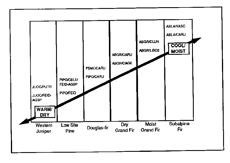
Figure 1.  Plant Association Groups described for the Ochoco National Forest.


Seral/Structural Stages.  Once the environmental gradient is classified by plant association

group, the next step is to classify the existing plant communities that occur within a group.

A successional classification is useful for this purpose.  A common conceptual model of

secondary succession is shown in Figure 2.
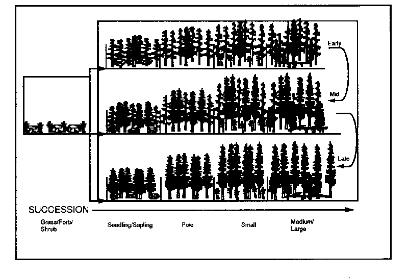
Figure 2.  Matrix model of succession in a grand fir forest.


The two axis in the matrix model are size/structure and species composition.  Five

size/structure stages are recognized (Table 1).


TABLE 1. SIZE/STRUCTURE CLASS DEFINITIONS.


Grass/Forb/Shrub			Trees may be present but are not the dominant vegetation

Seedling and Sapling 			<4.9" dbh

Pole     				5" - 8.9" dbh

Small      				9" - 20.9" dbh

Medium and Large			21" +  dbh


Note: Multi-story stands are stratified into the largest structural class that has 30 percent

or more of the canopy cover. On drier sites, the site may be fully occupied with less than

30 percent canopy cover. In this case the structure class would be based on the largest size

class that makes up a majority of the vegetation cover. This table decribes the range of

forest stucture conditions and is compatible with current inventory processes. These

classes are based on the average diameter of the trees in the dominant tree canopy. (Pacific

Meridian Resources 1992).  The species composition axis is divided into three stages:

early, mid, and late seral.  In the early seral stage, shade intolerant species dominate.

Mid-seral stages are dominated by mid-tolerant trees or by mixtures of shade tolerant and

intolerant tree species.  Late seral stages are dominated by shade-tolerant tree species.

Table 2 displays the matrix model of succession in a tabular form.
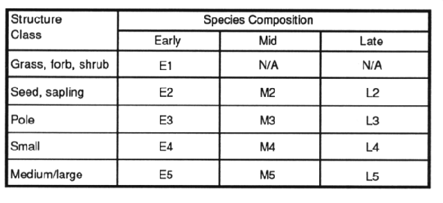
TABLE 2. Seral/Structure Matrix
The seral/structural classification scheme serves as a model for describing historic
conditions and management direction. Each seral/structural stage is not a uniform
condition across the landscape, but varies by species composition, number of canopy
layers, and density (stocking levels). These stages are useful for assessing the successional
progress of a stand and predicting the next plant community to occupy the site.
APPLICATION
Background
The intent of the Viable Ecosystems Policy is to assist in producing a landscape vegetation
condition that assures viability for all indigenous plants and animals. It is intended to be
implemented at the sub-watershed scale during the integrated resource analysis (IRA)
process. This policy links both the coarse and fine filtered aspects of ecosystem
management. Decisions for actual treatments are made at the fine filter level (individual
stands and individual species treatments). Coarse filter application comes from describing
and monitoring the abundance of seral/structural conditions at a forest-wide scale. This
provides for vegetation (habitat) diversity, through the allowance of localized over- and
under-abundance. For example, if a sub-watershed analysis showed an excess of the M5
condition of the dry Grand Fir plant associations, the forest-wide view may show a lack of
that condition. That would help frame the purpose/need for planning in that sub-
watershed, i.e. treatment of the M5 condition would still probably not be appropriate.
Similarly, if both the sub-watershed and forest-wide analysis showed an abundance of the
M4 condition in dry Grand Fir, you would place a high priority on treatment of this
condition to move it into a condition class where there are shortages.
The interdisciplinary team uses site-specific analysis of the vegetation mosaic and
determines specific acres to be treated. Consideration of special landscape features such
as riparian zones, cliff faces, non-forest vegetation, etc. is given in relation to their
juxtaposition with the forested environment.
Data Sources
PMR Data; Interpretation and Mapping. The vegetation mapping done by Pacific
Meridian Resources under contract to USFS Region 6 uses Landsat imagery and covers
all USGS quadrangles that include National Forest land. The mapping consists of multi-
spectral analysis of Landsat images to produce pixel maps of vegetation characteristics at
a resolution of 25 meters.
These pixel maps include information on size/structure, species composition, and canopy
closure. The PMR pixel data was incorporated into the Forest's geographic information
system (GIS) through the GRID module of ArcInfo. The two pixel layers which proved
the most useful for this application were size/structure and species composition. The
size/structure pixel layer consists of 36 categories (see Appendix). The Team grouped
these 36 categories into the five size/structure categories described in the seral/structure
matrix shown on page 5. In GRID, these PMR categories were RECLASS'ed as values 1-5
as shown in the Appendix.
The species composition pixel layer contains 97 categories for the Ochoco National
Forest. The Team grouped the 97 species categories into three representative seral stages
for each of the six plant association groups as shown in Table 3. These three groupings
represent the Early (E), Mid (M), and Late (L) seral stages described in the seral/structure
matrix on page 5.
Table 3. Species Composition Data (reclassified by PMR from Landsat imagery)
combined with plant association field data to derive seral stage.
Species Category Plant Association Group
Value/Description MA DA DF PP WJ SA
8 /abgr//// L L na na na na
9 /abgr//mix// L L na na na na
10 /abgr//pipo// M M na na na na
...
etc.
Field Inventory. Plant association mapping was completed by field personnel and
manuscripted as a separate GIS layer. These plant associations were stratified into the six
plant association groups presented under METHODS. In GRID the plant association
polygons were POLYGRID'ed via a lookup table that assigned the plant association to
one of the six groups as follows: Moist Grand Fir group (MA) = 100, Dry Grand Fir
group (DA) = 200, Douglas Fir group (DF) = 300, etc.
Analysis
The analysis process consists of comparing the existing seral/structural conditions with the
desired conditions for each plant association group.
In GRID, the LANDSAT-derived species layer is RECLASS'ed into six separate layers
(one for each plant association group) with values of 10 (Early seral), 20 (Mid seral), and
30 (Late seral) as shown in Table 3 above. This layer and the LANDSAT-derived
size/structure layer are then combined to create a new layer of Seral Stages by Plant
Association Group. In GRID these layers are simply added together to model Table 2 on
page 5 (e.g. 11 = E1, Early seral/grass, forb, shrub; 12 = E2, Early seral/seedling,sapling;
etc.). When added to the POLYGRID'ed plant association layer, the resulting grid has the
following values:
Value = xyz e.g. 134 = Moist Grand Fir/Late seral/Small trees
x = 1-6 y = 1-3 z = 1-5
1 Moist Grand fir plant association group 1 Early seral 1 Grass/forb/shrub
2 Dry Grand fir plant association group 2 Mid seral 2 Seedling/sapling
3 Douglas fir plant association group 3 Late seral 3 Poles
4 Ponderosa pine plant association group 4 Small trees
5 Western juniper plant association group 5 Med/large trees
The next step is to generate a table comparing existing conditions and desired conditions
based on the historical range of variation. These are summarized by plant association and
displayed in Table 4 on the next page. This table is a specific example using the Moist
Grand Fir Plant Associations in the Trout Creek Watershed as an illustration. Percent
refers to the percentage of land within the watershed.
Table 4. Final Report from the Pushbutton Viable Ecosystems Application
Trout Creek Watershed
Existing Condition Desired %
Matrix Acres Pvt. % Min. Max. % Difference Acres
Diff.
MOIST GF E1 682 0 9 5 12 0 0
MOIST GF E2 22 0 0 5 12 -5 -352
MOIST GF E3 913 23 12 5 15 0 0
MOIST GF E4 1,205 15 17 2 10 7 492
MOIST GF E5 176 0 2 2 5 0 0
MOIST GF M2 98 0 1 3 10 -2 -140
MOIST GF M3 1,293 10 18 5 20 0 0
MOIST GF M4 2,110 6 29 15 40 0 0
MOIST GF M5 193 0 2 10 20 -8 -563
MOIST GF L3 24 0 0 1 5 -1 -70
MOIST GF L4 103 0 1 4 8 -3 -211
MOIST GF L5 168 0 2 4 8 -2 -140
NON-FOREST 52 0 0 0 0 0 0
Maps are then constructed which display the spatial distribution of seral/structural stages
across the landscape. In this map the pixel data is filtered by a neighborhood analysis
technique to consolidate larger areas of like seral/structural stages. This map can be
further processed to identify stands of specific acreages or within certain management
allocations. This process can also be used to generate maps for special purposes such as:
- Present and potential Threatened and Endangered species habitat
- Insect and disease risk ratings
- Fire hazard ratings
Table 4 and the map are then used to provide the purpose and need for any management
activity and the location of the seral/structural conditions potentially treated by that
activity. Prescriptions for any vegetative manipulation of a given seral/structural stage will
be dictated by the surrounding seral/structural stages and special landscape features.
GRID notes of interest
Some of the challenges of writing this AML were meeting specific needs of the Team,
such as removing stands of less than five acres, programming INFO to match existing vs.
desired conditions, or generalizing the data for display purposes. Dealing with missing
plant association groups and/or private land in the DO loops was also a challenge.
CONCLUSIONS
Example Results
Table 5 displays some possible management strategies to bring the vegetation within the
Trout Creek Watershed back within the historical range of variation.
Table 5 Management strategy for Trout Creek watershed based on current distribution of
size/structural stages.
Seral/Structural Stage Strategy
M3 and M4 Thin from below to promote growth to M5. Look for opportunities
to promote L4 and L5 conditions-either with or without treatments.
Emphasize creating or maintaining large blocks for old growth for
old- growth habitat in the Moist ABGR plant association group.
E3 and E4 Thin or prescribe burn to promote E5 and prevent bark beetles.
E1 Encourage species variety to insure some stands moving into the M2 and L2 or L3 classes.
Key Points
- This Application classifies vegetation on a landscape basis.
- Management of vegetation is based on existing and potential conditions, not via set-asides.
- The Viable Ecosytems policy applies Ecosystem Management principles to the ground.
- It has become an integral part of Watershed Assessment.
- It manages the landscape for a mosaic of vegetative types
- Commodities are a product of the application, not driving it.
- Viable Ecosystems has created a new common jargon on the Ochoco National Forest, where
fuels technicians, silviculturists, or timber planners can visualize the same stand
structure and composition from the words M4 or L5.
ACKNOWLEDGEMENTS
The author wishes to thank the entire Viable Ecosytems Quality Action Team from whose
guide much of this paper is plagerized. Pacific Meridian Resources has provided the
Ochoco National Forest with high quality spectral analysis and image processing that has
greatly aided the development of this application.
APPENDIX Grouping of PMR Reclassified Landsat Imagery
Viable Ecosystem Class Landsat Code and Description
1. Grass/Forb/Shrub 4. Grass
7. Shrub-vigorous
8. Shrub-decadent
2. Seedling/Sapling 10. Seed-Sap-Pole
35. Sm/Seed
36. Med/Seed-Sap
3. Pole 11. Pole
12. Pole/Sm
20. Pole/MSLD
21. Pole/MS+
22. Pole/MS++
37. Lg/Seed-Sap-Pole
38. Gt/Seed-Sap-Pole
4. Small 13. Sm
14. Sm/Md
23. Sm/MSLD
24. Sm/MS-
25. Sm/MS+
26. Sm/MS++
39. Gt/Sm
5. Medium/Large 27. Med/MSDL
28. Med/MS-
29. Med/MS+
31. Lg/MS-
Example definition of a Size/Structure category:
Lg/MS- (Large/Multi-Sized minus)
This vegetation polygon did not meet single or two-sized canopy criteria or a multi-sized
criteria. There is at least 30% crown closure in Large. There is a higher percentage of
crown closure in trees smaller than large than in trees larger than Large (hence the "-").
This is a common class in large old growth vegetation polygons. This category typically
has a "broken" canopy with structural diversity and trees in many of the size classes.