California's widely diverse rivers are among the state's most valuable resources. Rivers are also among California's most damaged ecosystems because of the many demands placed upon them over time. In 1992, the California Resources Agency determined there was a need to develop a good foundation of river-related information to assist planning and decision-making. The California River's Assessment (CARA) was thus begun and now comprises more than twenty federal, state and local agencies, and private organizations.
The purpose of CARA is to develop an information system that can provide a comprehensive inventory and evaluation of California's river resources and to make this information easily accessible to decision-makers and the general public. The World-Wide Web serves as a vehicle for disseminating this data in a user-friendly fashion. Our intention is to move beyond the simple display of static snapshots of river data by allowing non-specialist users to query public information on river resources. The strategy is to make the GIS and databases accessible through the World-Wide Web using readily-available access software, which is also being incorporated by the commercial on-line services. Equally important is the ability to remotely submit updates and corrections using the same software systems.
Maintaining safe and reliable water supplies is critical to California's agriculture, urban areas, freshwater and anadromous fisheries, and environmental protection. Until recently, however, there had been no central location for storing river-related environmental data. In order to establish priorities for protection and restoration of river resources, there emerged a strong need to systematically rank the status of and threats to California rivers. In an effort to meet this need, the California Resources Agency began the California Rivers Assessment (CARA) in 1992. Since that time, 28 other state, federal, and private environmental agencies and organizations have joined as participants on various committees and working groups that help establish and implement the project's goals.
CARA is designed to make previously inaccessible data available to a wide variety of users, from government decision-makers to county planners and local watershed groups. More specifically, CARA's goals include the following:
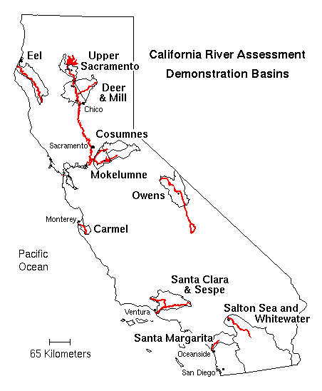
CARA has made major contributions and corrections to important public databases, including EPA River Reach and Impaired Water Body files, watershed designations, and native fish distributions. Initial work has concentrated on 13 demonstration basins, and this has included an extensive, searchable bibliography on river resources. We have developed Internet access using freeware (copyrighted but freely usable software, such as WWW, WAIS, and gopher).
In order to fulfill its goals, CARA is establishing a system for collecting, storing, analyzing, exchanging and retrieving river-related resource data on an on-going basis. These efforts have been broken into two phases, the Professional Judgement Assessment (PJA) and the Aggregated Information Model (AIM).The knowledge and opinions of river resource managers and river-related interest groups are being solicited in order to collect data on riparian and aquatic conditions and to identify those areas of the state where ecological integrity is at risk. Information in the PJA database includes:
A Professional Judgement Assessment questionnaire is being used to obtain targeted information, by river segment, in each of the state's 160 watersheds. As of the time of writing, the database includes completed questionnaires from over 600 experts covering at least 400 river segments.
Internet resources for CARA are housed within the Information Center for the Environment (ICE) at UC Davis. ICE is a bootstrap cooperative project that is developing easy-to-use public access to a wide variety of environmental information, located both on the ICE Web server and throughout the rest of cyberspace. A diverse group of supporters, including
the California Biodiversity Council,
the California Department of Fish and Game,
the California Department of Parks and Recreation,
the California Water Resources Control Board,
the Long Term Ecological Research (LTER) Program of the National Science Foundation,
the Man and the Biosphere Directorate at the State Department,
the National Biological Service (NBS),
the National Park Service,
the Nature Conservancy,
the US Environmental Protections Agency (EPA),
help fund ICE activities.
We support databases and Internet tools for all
of these organizations
and have helped hundreds
of users who had no previous access or
experience get connected to the Internet.
ICE also maintains extensive lists
of on-line environmental and other bibliographies,
of data management and meta-data sources,
and
of other environmental sites on the Internet.
The ICE Web server is now accessed over 14,000 times per week from all over
the world.
ICE may be accessed over the World-Wide Web using one's favorite Web browser (such as Mosaic, Netscape, or Cello) at
or from numerous other environmental or governmental servers.
The home page for CARA is accessible from the ICE home page or by directly going to
Most base layers for the CARA project have been provided by the California State Teale Data Center through our Memorandum of Understanding with the Department of Fish and Game and the California Department of Forestry. Unfortunately, we are unable to redistribute this data in its raw form to other members of the public because of the nature of the agreements under which Teale data are supplied. Teale is required by state policy to recharge users for the costs of assembling and disseminating its data holdings. Current policy leads to an annual subscription charge of about $10,000, placing access to Teale data out of the reach of many organizations, such as local planners and watershed groups, which are dependent upon reliable river data. Our base hydrology layer originated as the EPA River Reach file, but has been enhanced by Teale, and therefore is also no longer free to the public. We are, however, able to allow users to view and query derived data and maps via the Internet.
Currently, each of the demonstration basins has maps available for several themes, including vegetation, shaded relief, land ownership, major roads, natural diversity database (NDDB) occurrences, and rivers. These individual maps are available in PostScript format to facilitate downloading and printing by the user. The CARA Web documents also contain active links to related projects, including local watershed groups.
An important capability requested by our Internet users, who include watershed groups and agency scientists, is the ability to produce customized maps. Several other organizations had designed interactive map-making systems, which work over the Web, using various methods. About half are custom, in-house mapping programs, while a few others invoke Arcplot to produce maps. An attractive example of a custom-written system is the National Atlas Information Service (NAIS) in Canada. This is located at
The University of Edinburgh in Scotland has established a WWW to ArcInfo mapping capability which runs Arcplot in the background and uses remote procedure calls (RPC) to pass plotting jobs to Arcplot. This service is at
Developing a WWW to ArcInfo interface for CARA required programming expertise with ArcInfo, UNIX, and Web server software. We had already written an AML that produces a plot of individual layers within the CARA demonstration basins. It was straightforward to modify the existing AML to accept parameters (arguments) defining the map to be produced.
The processing steps of the CARA GIS Query System are:
The last three of these steps are accomplished by a Web server CGI program written in Perl. CGI (Common Gateway Interface) is a formal specification for running arbitrary programs from a Web server. Perl is a public domain scripting language that is commonly used for CGI programs. We chose it as the link between the HTML forms interface and ArcInfo mainly because our UNIX expert wanted to learn Perl and this use presented a suitable opportunity. (Perl is an acronym that expands to either "Practical Extraction and Report Language" or "Pathologically Eclectic Rubbish Lister" according to Wall and Schwartz 1991 .)
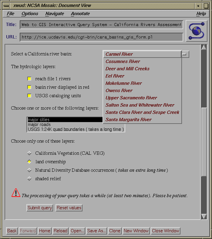
Perl also plays a part in Step 1. It generates the HTML forms interface, which is shown in Figure 2. The purpose of this sleight of hand is to allow run-time configuration of the interface. We wanted to link the GIS Query System to each of the individual basin home pages and have the pop-up menu for choosing the river basin be pre-set to the appropriate basin name. The CGI system permits parameters to be passed to the CGI program as part of the Web URL (Uniform Resource Locator, a glorified name for a document address on the Internet). In this case, we pass the name of the river basin as the parameter to the forms-generating Perl script. The user still may change the pre-configured basin to one of the other choices.
The user interface for the GIS Interactive Query System depicted in Figure 2 shows a request for the Carmel Basin. Any of the three hydrologic layers may be selected (all three are selected here), along with any of the other three basic point and line layers (major cities, major roads, and USGS 24K quad boundaries). Finally, the user may choose one of the last four layers (vegetation, ownership, NDDB occurrences, or shaded relief). In this case, land ownership was selected.
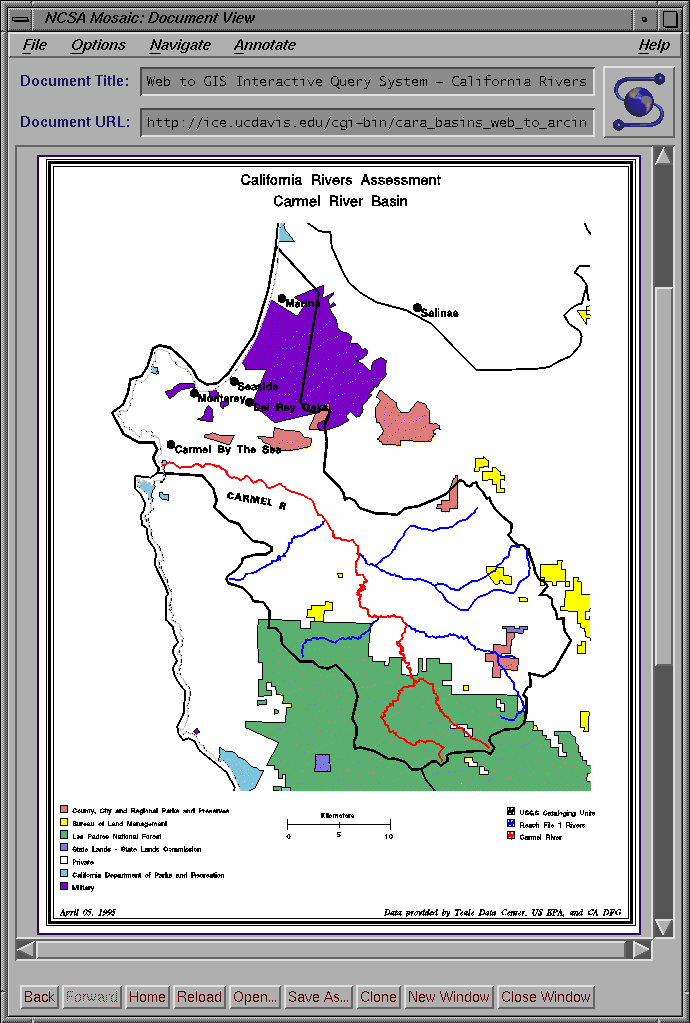
The response page is generated on-the-fly by the Perl script. In addition to the in-lined display of the map in GIF format (shown in Figure 3), a PostScript version of the map is produced, which may be viewed on-screen or downloaded for printing.
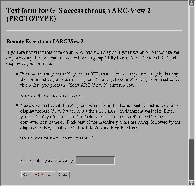
Another method we are considering for interactive access to CARA's data is to use ArcView2 through the CARA Web server. The attraction of ArcView2 is its programmable user interface and its direct access to the data, unmediated by a Web-CGI program. We have a working implementation of this method (see Figure 4). Based on a parameter supplied by the user through an HTML form, ArcView2 is run on a computer at ICE and displays to the user's X Window terminal. We plan to enhance this system using Avenue to customize the interface to the particular data involved, to prevent the user from changing the database, and to enforce any necessary data security.
The few preliminary tests by users located outside of California indicate the amount of network traffic or the number of X resources needed by ArcView2 at the user's end may lead to reliability problems with this method. Further testing is needed. Despite the difficulties encountered, we feel the use of ArcView2 over the WWW has great potential for opening up CARA's data to a wide audience.
A related Web technique we plan to use is the ability to query non-GIS databases from the Web. For example, some of the data from the Profession Judgement Assessment is inappropriate to a GIS. They are kept instead in a regular database management system. We propose to use an SQL server to answer queries about the data submitted from the Web server. Other ICE activities entail a number of non-spatial databases that also plan to use this same technique.
Environmental decision making in California and throughout the country is becoming increasingly decentralized. Hundreds of cooperative grassroots organizations, such as watershed councils, cooperative resources management planning efforts, and friends of the river groups, have emerged to promote environmental protection and restoration work. Local planning agencies have increased responsibility for identifying lands and waterways of particular value or under immediate threat. State and federal agencies have been particularly active in supporting projects to protect rivers and watersheds, yet these agencies need to better understand the successes and limitations of competing approaches.
All of these activities require a body of environmental information that is freely available and is viewed by competing parties as reliable and impartial. To meet this need, new cross-organizational data access centers are needed. Information must be accessible at low cost and in standardized formats to the non-specialists of impoverished grassroots groups and local governments. Given their diverse needs and capabilities, users should be able to customize queries and maps to their individual requirements.
California Rivers Assessment provides one model of how to better deliver environmental information to the public. Users may access statewide databases and GIS coverages of river environments through standardized, freely-available software. We have already demonstrated interactive Web access to river data. It is equally important to provide mechanisms for users to update, expand, and correct entries in the databases. We anticipate being able to demonstrate the remote submission of updates for CARA databases using HTML forms in the near future. A more complete solution to a genuine statewide, distributed data system for river environments awaits new technologies.
Karen Beardsley
GIS Coordinator, California Rivers Assessment
Division of Environmental Studies
University of California, Davis
Davis, California 95616
Telephone: (916) 752-0532
Fax: (916) 752-3350
E-mail:
kbeardsley@ucdavis.edu
Harvey Chinn
Ice Master, Information Center for the Environment
E-mail:
harvey@ice.ucdavis.edu
James F. Quinn
Director, Information Center for the Environment
Co-PI, California Rivers Assessment
E-mail:
jfquinn@ucdavis.edu