A computer program named Basinsoft is being developed to use geographic information system (GIS) software to quantify 27 selected morphometric characteristics for a drainage basin using digital cartographic data. The characteristics quantified include the basin measurements of area, length, slope, relief, shape, and aspect, and the channel (stream) measurements of length, slope, sinuosity, density, order, and frequency. Basinsoft was originally developed in 1988 to use digitized topographic-map data to quantify 16 selected morphometric characteristics. Since the original coding of Basinsoft in 1988, the programs comprising Basinsoft have been further developed and extensively upgraded. They have been converted from PRIME(1) to Data General UNIX operating systems, tested to verify the accuracy of quantifications, and documented. The programs now comprising Basinsoft are written entirely using Arc Macro Language (AML) to ensure portability between computer platforms running ArcInfo revisions 7.0 or greater.
Basinsoft requires the generation of four source-data layers representing the drainage divide, hydrography, hypsography, and an elevation model of a drainage basin; and the assignment of attributes to three of the four source-data layers. Generation of and assignment of attributes to these data layers is facilitated by utility programs developed specifically for these purposes. An optional program included with Basinsoft can be used to quantify area-weighted characteristics for a drainage basin. Area-weighted characteristics can be quantified from a variety of potential data sources that represent the distribution of characteristics such as precipitation, land use, soils, and geology.
Comparison tests between Basinsoft quantifications and manual topographic-map measurements of 12 primary basin characteristics support the validity of Basinsoft computations. Results indicate that Basinsoft quantifications of basin slope are dependent on source data used to generate the hypsography source-data layer. Because of inherent differences between the data sources, basin slope is accurately quantified when digitized topographic-map data are used to generate the hypsography source-data layer and significantly underestimated when digital-elevation-model data are used.
Compared to manual methods of measurement, Basinsoft significantly decreases the amount of time and effort required to quantify selected basin characteristics. The simplicity and automation of Basinsoft, and accompanying utility and optional programs, facilitates application of Basinsoft without requiring extensive GIS experience. In addition to multiple-basin processing for regional studies, Basinsoft can also be used to process single basins to quantify input characteristics for hydrologic modeling.
(1)The use of trade, product, industry, or firm names is for descriptive purposes only and does not imply endorsement by the U.S. Government.
INTRODUCTION
Surface-water runoff is a function of many interrelated factors including climate, soils, land-use, and the physiography of the drainage basin. A practical and effective method to quantify drainage-basin characteristics would allow analysis of the interrelations of these factors, leading to an improved understanding of the effects of drainage-basin characteristics on surface-water runoff. Historically, the quantification of drainage-basin characteristics has been a tedious and time-consuming process. Recent improvements in computer hardware and software technology have enabled the developers of a program called Basinsoft to automate this process. Basinsoft requires minimal preprocessing of data and provides an efficient, automated procedure for quantifying selected morphometric characteristics and the option to area-weight characteristics for a drainage basin.
Development of the Basinsoft program is continuing. Information regarding the status of this program may be obtained by accessing the U. S. Geological Survey, Iowa District Internet Home Page at http://dg00diaiwc.cr.usgs.gov/index.html, by sending email to basinsoft@maildiaiwc.cr.usgs.gov, or by contacting the U. S. Geological Survey, Room 269, Federal building, 400 South Clinton Street, Iowa City, Iowa 52244 (telephone at (319) 337-4191).
HISTORY OF THE DEVELOPMENT OF BASINSOFT
In 1988, the USGS began developing a program called Basinsoft. The initial program quantified 16 selected drainage-basin characteristics from three source-data layers that were manually digitized from topographic maps using the versions of ArcInfo, Fortran programs, and Prime system computer programming language (CPL) programs available in 1988 (Majure and Soenksen, 1991). By 1991, Basinsoft was enhanced to quantify 27 selected drainage-basin characteristics from three source-data layers automatically generated from digital elevation model (DEM) data using a set of Fortran programs (Majure and Eash, 1991; Jenson and Dominique, 1988). Due to edge-matching problems encountered in 1991 with the preprocessing of the DEM data, the Basinsoft program was subsequently modified to quantify 24 selected drainage-basin characteristics from four source-data layers created from three types of data (topographic maps, digital line graph (DLG) data, and DEM data) (Eash, 1993; Eash, 1994). The early versions of Basinsoft relied primarily on Fortran programs and Prime system CPL to manage data and calculate statistics, thus making them platform dependent.
In 1994, Basinsoft was redeveloped entirely using Arc Macro Language (AML) to increase portability among systems using ArcInfo version 7.0 or later (Environmental Systems Research Institute, 1994). The current version of Basinsoft processes four source-data layers representing selected aspects of a drainage basin to quantify selected morphometric drainage-basin characteristics. The 27 selected basin characteristics quantified by Basinsoft are listed in appendix A as measurements or computations. Twelve of the drainage-basin characteristics constitute specific quantifications of area, length, relief, aspect, and stream order; the other 15 characteristics are computations that make use of the various quantifications to calculate other drainage-basin characteristics or statistics.
DESCRIPTION OF BASINSOFT PROGRAM
STRUCTURE
The AML programs comprising Basinsoft are initialized so that each program performs specific tasks and when necessary, passes information required by the following program for subsequent processing. By programming in this modular manner, additional or future modules are easily appended to Basinsoft by the user.
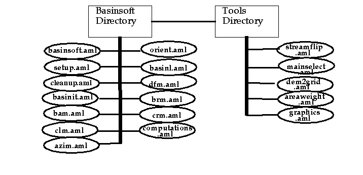
The "core" AML programs comprising Basinsoft, listed with their associated functions in table 1, are referred to as modules in this paper. Basinsoft.aml controls the modules found in the basinsoft directory (fig. 1) and can be modified to control some of the utility programs found in the tools directory (fig. 1). Modules are executed each time Basinsoft is initiated. Drainage-basin characteristics are quantified within the modules. Examples of the directory structure required by Basinsoft are listed in table 2 and shown on figure 2.
Figure 1. Example of Basinsoft program directory structure.
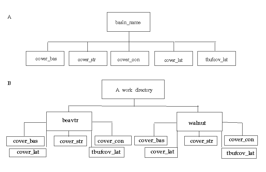
Figure 2. Naming conventions and directory structure required for processing multiple drainage-basins.-- (A) generic directory structure of single basin, (B) actual directory structure for multiple basins (e.g. beavtr and walnut) maintained under a work directory.
Table 1."Core" AMLs and associated
functions
---------------------------------------------------------------------------
AML name          AML function(a)
---------------------------------------------------------------------------
basinsoft.aml     Driver AML, initiates other core AMLs.
setup.aml         Defines system specific commands or syntax.
cleanup.aml       Removes residual files and coverages from previous
                    Basinsoft runs.
basinit.aml       Initializes variables and creates an empty INFO table to
                    hold drainage-basin characteristics as they are
                    quantified by Basinsoft.
bam.aml           Quantifies TDA, NCDA, CDA.
clm.aml           Quantifies MCL and TSL.
azim.aml          Quantifies BP and BA.
orient.aml        Calculates and sets the global variable ".orient".
basinl.aml        Quantifies BL.
dfm.aml           Quantifies FOS, BSO, DF.
brm.aml           Quantifies BS and BR.
crm.aml           Quantifies MCS.
computations.aml  Quantifies BW, SF, ER, RB, CR, RR, MCSR, SD, CCM, MCSP,
                    RN, SR, and RSD.
---------------------------------------------------------------------------
TABLE 2. Naming conventions and description of directory structure
required by Basinsoft
---------------------------------------------------------------------------
Directory name   Description of directory
---------------------------------------------------------------------------
basin_name       This is the unique name defining a specific drainage basin
                   (e.g. beavtr). The following data layers are source-data
                   layers maintained under the basin_name directory.
cover_bas        Drainage-divide data layer.
cover_str        Hydrography data layer.
cover_con        Hypsography data layer.
cover_lat        Lattice data layer with areal extent
                   clipped to drainage-basin boundary.
tbufcov_lat      Lattice data layer with areal extent to clipped buffered
                   basin boundary.
--------------------------------------------------------------------------
COMPUTER RESOURCES REQUIRED TO EXECUTE
BASINSOFTBasinsoft was developed and tested on Data General Avion model 300, 530, and 550 workstations using ArcInfo version 7.0, 7.0.1, and 7.0.2. Basinsoft requires no compilation. The setup.aml can be modified to configure Basinsoft to run on various computer platforms and to reflect system-specific usage or syntax requirements.
Processing time to execute Basinsoft varies between 5 and 20 minutes on a Data General Avion 530 for drainage-basins with areas less than 3,000 square miles. Processing time on other systems may vary depending on their hardware capabilities. These processing times do not include time for preprocessing, which will vary according to the type of source data available for generating the four source-data layers required as input to Basinsoft. The basin-length module also is computer-time, memory, and disk-space intensive.
SOURCE-DATA REQUIREMENTS OF
BASINSOFT
Basinsoft requires the user to provide four source-data layers. These data layers are not required to be of any specific scale, however, the hydrography and hypsography data layers should be clipped to the areal extent of the drainage-divide data layer. The lattice elevation model is preprocessed into two lattice data layers -- cover_lat, with the same areal extent as the drainage-divide data layer, and tbufcov_lat, with an areal extent set to a buffered region slightly larger than the drainage-divide data layer.
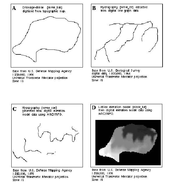
Figure 3. Example of four source-data layers required by Basinsoft --(A) drainage-divide data layer, (B) hydrography data layer, (C) hypsography data layer, (D) lattice elevation model data layer.
Basinsoft was developed to run with minimal preprocessing; however, there are several steps required to prepare the source-data layers for subsequent processing by Basinsoft. Preprocessing steps include the generation of the four source-data layers and the assignment of attributes. The main channel of the drainage basin must be delineated, attributed, and extended to the drainage-divide. Several programs were developed to assist the user in preprocessing source-data layers in preparation for use with Basinsoft. These programs perform various tasks such as creating a hydrologically accurate lattice elevation model, facilitating the creation of a hypsography data layer, and converting a 1:250,000-scale DEM to a lattice data layer. Several programs were developed to assist the user in assigning attributes to data layers according to a specialized attribute scheme required by Basinsoft.
PROCESSING DATA LAYERS TO QUANTIFY DRAINAGE-BASIN
CHARACTERISTICS
Basinsoft processing can be performed on either single or multiple basins. The process of quantifying basin characteristics for a number of drainage basins is highly repetitive; therefore, it is possible to automate much of this task once the preprocessing has been completed. Processing involves invoking the program Basinsoft.aml to quantify 27 selected morphometric drainage-basin characteristics. Optional programs are included in the tools directory for use with Basinsoft.
A program to weight data by area, named areaweight.aml, is located in the tools directory. This program can be used as a module or as a stand-alone program to quantify characteristics from a variety of data, such as climatic data (annual precipitation and the 2-year 24-hour precipitation intensity), which are stored in multi-polygonal data layers (Eash, 1993). Minimal preprocessing is needed to execute this module. The areaweight.aml requires statewide or large area multi-polygonal data layers representing the distribution of a characteristic, such as precipitation values, land-use values, pedologic values, geologic values, etc. The multi-polygonal data layer must be larger than and encompass the drainage-divide data layer. Output is written to an auxiliary file specified by the user on the command line.
Basinsoft output is generated in three formats. An INFO table, an ascii file (table 3), and an optional graphical output (fig 4).
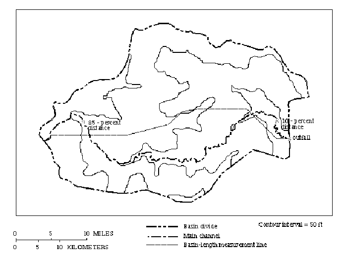
Figure 4. Example of graphical output from Basinsoft.
Table
3. Example of flat file (ASCII) output from Basinsoft
-------------------------
Basin Name  =  beavtr
 TDA        =      11.890
 NCDA       =       0.000
 CDA        =      11.890
 BL         =       5.271
 BP         =      15.528
 BS         =      53.549
 BR         =     151.246
 BA         =      55.063
 BW         =       2.256
 SF         =       2.336
 ER         =       0.739
 RB         =       1.834
 CR         =       1.270
 RR         =       9.740
 MCL        =       5.689
 TSL        =      15.086
 MCS        =      23.381
 MCSR       =       1.079
 SD         =       1.269
 CCM        =       0.788
 MCSP       =       1.176
 RN         =     191.896
 SR         =       0.437
 FOS        =       6.000
 BSO        =       3.0
 DF         =       0.505
 RSD        =       0.313
-------------------------
BASINSOFT VERIFICATION
Table 4. Comparisons of manual measurements and Basinsoft
quantifications of selected drainage-basin characteristics for 11
streamflow-gaging stations in Iowa
[TDA, total drainage area, in
square miles; NCDA, noncontributing drainage area, in square miles; BL,
basin length, in miles; BP, basin perimeter, in miles; BS, average basin
slope, in feet per mile; BR, basin relief, in feet; BA, basin azimuth, in
degrees; MCL, main-channel length, in miles; TSL, total stream length, in
miles; MCS, main-channel slope, in feet per mile; FOS, number of
first-order streams; BSO, basin stream order; MAN, manual measurement;
BSOFT, Basinsoft quantification; % DIFF, percentage difference between MAN
and BSOFT; ND, not determined; WSRT, Wilcoxon signed-ranks test; NT, no
test performed because all values for % DIFF = 0]
-----------------------------------------------------------------------------------------------------------------
Station Measure-
number  ment
        technique TDA(a)  NCDA    BL     BP      BS     BR       BA       MCL     TSL        MCS      FOS     BSO
-----------------------------------------------------------------------------------------------------------------

05411600   MAN   177      0     27.0    73.3    166     297      144      36.4    242         5.61     84       4
         BSOFT   178      0     25.6    73.9     73.6   280      143      36.3    236         6.14     84       4

        % DIFF    +0.6    0     -5.2    +0.8    -55.7    -5.7     -0.7    -0.3     -2.5      +9.4       0       0

05414450   MAN    21.6    0     8.81    21.9    426     444      104      11.4     31.9      19.1      10       3
         BSOFT    22.3    0     8.47    21.3    264     439      104      11.1     31.5      23.1      10       3

        % DIFF    +3.2    0    -3.9     -2.7    -38.0    -1.1      0      -2.6     -1.3     +20.9       0       0

05414600   MAN     1.54   0     2.31     5.32   246     280       68       2.63     2.63    101         1       1
         BSOFT     1.53   0     2.10     5.97   208     299       75       2.58     2.58    108         1       1

        % DIFF    -0.6    0    -9.1    +12.2    -15.4    +6.8    +10.3    -1.9     -1.9      +6.9       0       0

05462750   MAN    11.6    0     4.84    15.0    157     160       52       5.74    15.2      28.3       6       3
         BSOFT    11.9    0     5.27    15.5     53.5   151       55       5.69    15.1      23.4       6       3

        % DIFF    +2.6    0    +8.9     +3.3    -65.9    -5.6     +5.8    -0.9     -0.7     -17.3       0       0

05463090   MAN    56.9    0    11.6     33.5     ND     181       91      17.4     73.5       7.27     28       3
         BSOFT    57.0    0    11.4     33.1     52.3   187       89      16.8     73.9       8.67     28       3

        % DIFF    +0.2    0    -1.7     -1.2     ND      +3.3     -2.2    -3.4     +0.5     +19.3       0       0

05470500   MAN   204      0    24.4     69.8     99.6   318      150      37.8    210         7.52     60       4
         BSOFT   208      0    25.3     67.7     49.0   309      151      35.7    192         7.81     51       4

        % DIFF    +2.0    0    +3.7     -3.0    -50.8    -2.8     +0.7    -5.6     -8.6      +3.9     -15.0     0

05481000   MAN   844      0    51.5    139       ND     303      175      88.1    685         2.04    152       5
         BSOFT   852      0    52.3    139       33.4   269      176      88.9    685         1.50    155       5

        % DIFF   +0.9     0    +1.6      0       ND     -11.2     +0.6    +0.9      0       -26.5      +2.0     0

05489490   MAN   22.9     0    10.5     24.8    289     280       70      13.3     28.4      14.8      10       2
         BSOFT   22.2     0    10.6     26.2    165     286       68      13.0     27.6      20.2      10       2

        % DIFF   -3.1     0    +1.0     +5.6    -42.9    +2.1     -2.9    -2.3     -2.8     +36.5       0       0

06609500   MAN  871       0    80.9    206      352     537      201     101     1230         3.18    477       5
         BSOFT  869       0    81.7    210      197     491      203      99.9   1270         3.34    487       5

        % DIFF   -0.2     0    +1.0     +1.9    -44.0    -8.6     +1.0    -1.1     +3.3      +5.0      +2.1     0

06807780   MAN   42.7     0    21.1     47.4    346     268      204      22.2     52.7       9.37     18       3
         BSOFT   42.8     0    21.5     48.8    195     283      205      22.2     55.3      10.1      19       3

        % DIFF   +0.2     0    +1.9     +3.0    -43.6    +5.6     +0.5     0       +4.9      +7.8      +5.6     0

06903400   MAN  182       0    21.9     79.0    152     224       57      39.5    228         3.24     80       4
         BSOFT  184       0    21.3     79.6     82.2   200       57      39.6    231         3.37     80       4

        % DIFF   +1.1     0    -2.7     +0.8    -45.9   -10. 7     0      +0.3     +1.3      +4.0       0       0

WSRT p-value(b)   0.1192  NT    0.6248   0.2125   0.0092  0.2296   0.3447  0.0908   0.9291    0.1000    0.3742  NT
-----------------------------------------------------------------------------------------------------------------
The results of a qualitative comparison test for average basin slope (BS) using three methods of measuring elevation-contour lengths are listed in table 5. The results indicate that Basinsoft quantifies basin slope with acceptable results; however, ArcInfo is unable to generate appropriate elevation contours from 1:250,000-scale DEM data for comparison with manual measurements of elevation contours from 1:250,000-scale topographic maps. Comparisons for basin slope (tables 4 and 5) appear to indicate that the 1:250,000-scale DEM data are too coarse for ArcInfo to accurately reproduce elevation contour data with the sinuosity found on the 1:250,000-scale topographic maps. Figure 5 shows elevation contours generated from DEM data using ArcInfo (fig. 5A) are much more generalized than elevation-contours digitized from topographic maps of the same scale (fig. 5B). Thus, the total length of contours generated from DEM data are under-represented when compared to contours shown on topographic maps (table 5). This contour over-generalization illustrates how the total length of the elevation contours are underestimated by Basinsoft using the "contour-band" method to quantify basin slope (appendix A).
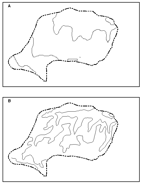
Figure 5. Elevation contours generated (A), with a 50-foot interval from 1:250,000-scale DEM data using ArcInfo and (B), with a 50-foot interval digitized from a 1:250,000-scale topographical map.
TABLE 5. Comparison of elevation-contour length measurements used to
quantify basin slope
-------------------------------------------------------------------------------------------------
                                                                                     Average
                                                                                     basin slope
                                                                                     quantified
Source data                              Elevation-                                  using
(all data                                contour length   Contributing    Contour    CL * CI/
were                                        (CL)          drainage area   interval   CDA,
1:250,000-                               measurement,     (CDA), in       (CI), in   in feet per
scale)        Method of measurement       in miles        square miles    feet       mile
-------------------------------------------------------------------------------------------------
Topographic   Manual measurement of      37.23            11.89           50         156.6
map           elevation contours from
              topographic map

Topographic   Basinsoft quantification   35.05            11.89           50         147.4
map           of elevation contours
(fig. 5B)     digitized from
              topographic map

DEM data      Basinsoft quantification   12.73            11.89           50         53.5
(fig. 5A)     of elevation contours
              generated using ARC/
              INFO
-------------------------------------------------------------------------------------------------
Understanding the reason for differences between the manual
measurements and quantifications made by Basinsoft is important in
determining the type of comparisons which may be relevant in analysis of
this type of data. The data in table 5 indicate that it is not preferable
to compare Basinsoft quantifications of contour data generated by ArcInfo
with either digitized contours or contours generated from DLG data;
however, it is assumed that measurements based on elevation contours
digitized from contour maps and those based on elevation contours generated
from DLG data would be similar.Basinsoft quantifications of main-channel slope (MCS) have the greatest range in percent difference between manual measurements and Basinsoft quantifications of the 10 selected drainage-basin characteristics listed in table 4. There are two main components of the MCS equation, length and elevation (appendix A). Quantification differences for MCS ranged from -26.5 to +36.5 percent (table 4). However, quantification differences for main channel length (MCL) ranged -5.6 to +0.9 percent (table 4). These quantification differences indicate that the variation between manual measurements and Basinsoft quantifications of MCS are due mainly to differences in the determination of the streambed elevation at points 10 percent and 85 percent of the distance along the main channel from the basin outlet.
The approximate time required for an experienced ArcInfo user to process three of the drainage basins listed in table 4 using Basinsoft was 8 hours. The three basins represent large, intermediate, and small drainage areas, respectively. Manual measurements made from the same scales of topographic maps as used by Basinsoft for these three drainage basins required approximately 50 hours.
Preliminary comparisons between basin-characteristic measurements made from various scales of cartographic data for the above three drainage basins, appear to indicate that several of the basin characteristics (BS, MCL, TSL, MCS, FOS, BSO) are map-scale dependent. (Eash, 1993; Eash, 1994). Map-scale dependency refers to the effect on a measurement when that measurement is made from a cartographic-data source of some specific scale as compared to that same measurement made from a different scale. Thus, interbasin comparisons of Basinsoft quantifications may be unreliable if different scales of cartographic data, or different sources of digital data (that is, raster versus vector), are used in generating the four source-data layers for each drainage basin.
Source-data layers obtained from larger-scale cartographic data and processed using Basinsoft can provide the best drainage-basin quantifications for a study area. However, the scales and sources of cartographic data available for a study area may be a limiting factor in generating the four source-data layers required by Basinsoft. In general, Basinsoft can process most scales and sources of cartographic data available for a study area once the preprocessing is complete for the four source-data layers (Majure and Soenksen, 1991; Majure and Eash, 1991; Eash, 1993).
SUMMARY
A computer program named Basinsoft has been developed by the U.S. Geological Survey to quantify 27 morphometric drainage-basin characteristics using a geographic information system. Basinsoft was developed entirely using AML to increase portablility among systems. Basinsoft uses ArcInfo AMLs written for ArcInfo version 7.0 or later. Basinsoft requires four source-data layers representing the drainage-divide, hydrography, hypsography, and a lattice elevation model of a selected drainage basin. Minimal preprocessing is required to prepare the source data used by Basinsoft. Optional programs and modules were developed to enhance the useability and functionality of Basinsoft.
Statistical comparison tests indicate that Basinsoft quantifications are not significantly different (p-value >.05) from manual topographic-map measurements for 9 of 10 basin characteristics tested. Results also indicate that elevation contours generated by ArcInfo from 1:250,000-scale DEM data are substantially over-generalized when compared to elevation contours shown on 1:250,000-scale topographic maps and that quantification of basin-slope thus is underestimated using the DEM data. A qualitative comparison test indicated that the Basinsoft module used to quantify basin slope is valid and that differences in quantified basin slope are due to source-data differences.
Basinsoft provides an automated computer procedure for the quantification of drainage-basin characteristics and reduces the amount of time required to quantify drainage-basin characteristics when compared to manual methods of measurement.
APPENDIX A
Selected Drainage-Basin Characteristics Quantified Using
Basinsoft
[superscripts (a-g), footnotes at end of
the appendix reference the literary source for drainage-basin
characteristics]
Basin-area quantifications
TDA - Total drainage area(a,b), in square miles, an
internal measurement maintained by ArcInfo. TDA is acquired from the
drainage-divide data layer (cover_bas) attribute table as the area
measurement and it includes noncontributing areas.
NCDA - Noncontributing drainage area(a), square miles, is the total area that does not contribute to surface-water runoff at the basin outlet. NCDA is obtained by computing summary statistics on the drainage-divide data layer (cover_bas) attribute table based on the item CONTRIB.
Basin-length quantifications
BL - Basin length(a), in miles, measured along a line areally centered through the drainage-divide data layer (cover_bas) from basin outlet to where the main channel extended meets the basin divide. This process uses ARC/GRID to calculate the center-line.
BP - Basin perimeter(a), in miles, measured along entire drainage-basin divide. BP is an internal measurement maintained by ArcInfo and is acquired from the drainage-divide data layer (cover_bas).
Basin-relief quantifications
BS - Average basin slope(a,b), in feet per mile, measured by the "contour-band" method, within the contributing drainage area (CDA). Summary statistics are performed on the hypsography data layer (cover_con). The output from the statistics command is used in conjunction with the user-designated elevation-contour interval as input into the formula to calculate BS. BS = (total length of all selected elevation contours)(contour interval)/CDA.
BR - Basin relief(c), in feet, measured as the difference between the elevation of the highest grid cell and the elevation of the grid cell at the basin outlet. BR uses the lattice (grid) data layer (cover_lat) to determine the minimum elevation as the land-surface elevation at the basin outlet. The maximum elevation is determined from the lattice data layer (cover_lat) statistics INFO file item ZMAX.
Basin-aspect quantification
BA - Basin azimuth(a,b), in degrees, compass direction of a line projected from where the main channel, if extended, would meet the basin divide downslope to the basin outlet. Measured clockwise from north at 0 degrees.
Basin computations
CDA - Contributing drainage area(a,b), in square miles, defined as the total area that contributes to surface-water runoff at the basin outlet, CDA = TDA - NCDA.
BW - Effective basin width(a), in miles, BW = CDA / BL.
SF - Shape factor(a), dimensionless, ratio of basin length to effective basin width, SF = BL / BW.
ER - Elongation ratio(a), dimensionless, ratio of (1) the diameter of a circle of area equal to that of the basin to (2) the length of the basin, ER = [4 CDA / pi (BL)^2]^0.5 = 1.13 (1/SF)^0.5.
RB - Rotundity of basin(a), dimensionless, RB = [pi(BL) ^2] / [4 CDA] = 0.785 SF.
CR - Compactness ratio(a), dimensionless, the ratio of the perimeter of the basin to the circumference of a circle of equal area, CR = BP / 2 (pi CDA)^0.5.
RR- Relative relief(d), in feet per mile, RR = BR / BP.
Channel- or stream-length quantifications
MCL- Main channel length(a,b), in miles, measured along the main channel from the basin outlet to where the main channel, if extended, meets the basin divide. Summary statistics are computed on the hydrography data layer (cover_str) based on the item CODE.
TSL- Total stream length(c), in miles, computed by summing the length of all stream segments within the CDA using summary statistics on the hydrography data layer (cover_str) based on the item (LENGTH).
Channel-relief quantification
MCS -Main-channel slope(a,b), in feet per mile, an index
of the slope of the main channel computed from the difference in streambed
elevation at points 10 percent and 85 percent of the distances along the
main channel from the basin outlet to the basin divide. A route system is
developed based on the INFO-item CODE equal to 1 in the hydrography
(cover_str) data layer. The 10 and 85 percent distances from the basin
outlet are calculated and nodes are placed at those positions along the
route. The nodes are converted to points and elevations are determined for
each point from the lattice data layer (cover_lat) and attributed to a
temporary data layer for use in the MCS formula. MCS = (E85 -
E10) / (0.75 MCL).
Channel (stream) computations
MCSR -Main-channel sinuosity ratio(a), dimensionless, MCSR = MCL / BL.
SD - Stream density(a), in miles per square mile, within the CDA, SD = TSL / CDA.
CCM - Constant of channel maintenance(a), in square miles per mile, within the CDA, CCM = CDA / TSL = 1 / SD.
MCSP - Main channel slope proportion(c), dimensionless, MCSP = MCL / (MCS)^0.5.
RN -Ruggedness number(e), in feet per mile, RN = (TSL) (BR) / CDA = (SD) (BR).
SR - Slope ratio of main-channel slope to basin slope(c), dimensionless, within the CDA, SR = MCS / BS.
Stream-order quantifications
FOS - Number of first-order streams within the CDA(f), dimensionless. FOS is computed using Strahler's method of stream ordering and summary statistics on the hydrography data layer (cover_str).
BSO -Basin Stream Order(f), dimensionless, stream order of the main channel at the basin outlet. BSO is computed by intersecting the main channel with the drainage-divide data layer and determining the Strahler-stream order of the stream at the basin outlet.
Stream-order computations
DF - Drainage frequency(c), in number of first-order streams per square mile, within the CDA, DF = FOS / CDA.
RSD -Relative stream density(g), dimensionless, within CDA, RSD = (FOS)(CDA)/(TSL)^2 = DF/(SD)^2.
__________________________________________________________________________
(a)Modified from Office of Water Data Coordination (1978,
p. 7-9--7-16).
(b)Modified from National Water Data Storage and Retrieval
System (Dempster, 1983, p.
--A-24 -- A-26).
(c)Modified from Strahler (1958, p. 282-283 and 289).
(d)Modified from Melton (1957).
(e)Modified from Robbins (1986, p. 12).
(f)Modified from Strahler (1952, p. 1120).
(g)Modified from Melton (1958).
REFERENCES