Successfully Processed Locations in PAMS

Developed in ArcInfo and linked to ORACLE, the GIS component to PAMS maintains a permanent, spatial inventory of application activity locations in Connecticut. Representing where permit application activities occur, activity locations include facilities, air stacks, landfills, surface and ground water discharges, wells, dams, bridges, marinas, etc. For each activity location in PAMS, GIS performs a series of spatial overlays, comparing the location with other baseline data layers including Connecticut town boundaries, the coastal boundary, the natural diversity database, subregional drainage basins, surface and ground water quality classifications, and USGS quadrangles. The results of the overlay process are then passed to PAMS as attributes. GIS populates the ORACLE tables and PAMS ties the new locational information to the permit application. Using PAMS, permit staff are then able to determine for themselves whether their application is in the coastal boundary, a natural diversity database area, or within the vicinity of a particular surface or ground water quality classification.
PAMS-GIS includes a graphical user interface for digitizing, viewing, and mapping application activity locations and a batch job for processing newly digitized application activity locations. The GIS batch job runs every 10 minutes during the work day and performs the spatial overlays, populates PAMS, and sends activity location checkplots to the nearest, appropriate printer.
GIS manages locational information associated with permit applications in PAMS, providing a database for integrating a variety of environmental, demographic, and facility related information. Permit staff using GIS to geographically reference permit activity locations have access to information tools they rarely had access to before. The GIS tools are very new to many of these people so understanding GIS and learning how to use it in PAMS is on their minds more so today than ever before (or at least it should be!). PAMS-GIS represents one of DEP's first large-scale GIS applications and a lot has been learned by both GIS and non-GIS types in the agency as the project progressed through the various design, development, testing, training, and implementation phases.
The following sections take a closer look at an example permit application and summarize how PAMS and GIS manage the associated locational information and present it to the user.

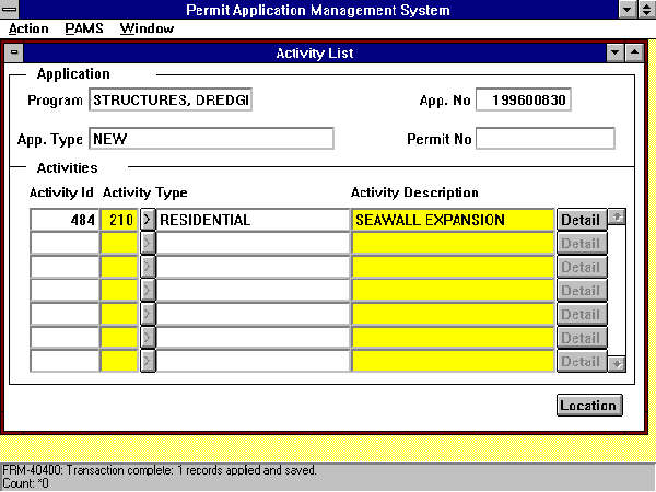
The example applicant used in this paper is an individual named John Smith who has submitted a Structures, Dredging and Fill application to the Office of Long Island Sound (OLISP) permitting Bureau. His permit application is for a residential activity that involves the expansion of the seawall bulkhead in front of his home. In PAMS, the Application Activity Location menu for John Smith's bulkhead shown above is accessed through the permit Application Header. The application activity location (Smith Bulkhead) represents where the activity occurs. The nature of the proposed activity is noted in the corresponding Activity List menu, and the associated OLISP Activity Detail menu identifies coastal resources within the vicinity of the activity (e.g. intertidal flats) and the corresponding activity class (e.g. bulkhead/seawall).
Activity locations are first added to PAMS and later digitized in GIS. In the menu above, the location Type (point, line or polygon) defines the GIS representation and Desc (description) is a general name for the location or site. Both fields are required input and are highlighted in yellow. As an alternative to digitizing, point locations may be created directly by entering latitude and longitude. This provision was included to accommodate the increasing use of Global Positioning System (GPS) receivers in locating regulated activities. The GIS Processing Status field displays Process: Digitized Coverage (Point) and describes the method for adding/processing the location in GIS. Other GIS Processing Statuses include those for digitizing a line, digitizing a polygon, and entering latitude and longitude to create a point. The GIS Id displayed in the upper right hand corner of the menu is assigned by PAMS and serves as the basis for linking locations in GIS to permit application information stored in PAMS. The PAMS generated GIS Id is 2006 and the Smith Bulkhead is now ready to be digitized. Once digitized, a GIS batch job processes the location, filling in the menu above with locational, environmental, and coordinate information.

Activity locations are digitized in ArcInfo using PAMS-GIS. The PAMS-GIS Digitize Activity Locations menu interface is accessed for digitizing new or moving previously digitized locations that require correction. The menu interface is comprised of a main menu in the upper left hand corner, drop down menus below for digitizing, a main viewing window to the right for displaying the quadrangle area, and a detailed viewing window in the lower left hand corner for panning, zooming and digitizing within the quadrangle area. To define the digitizing map extent, a quadrangle is selected from a scrolling list in a separate popup menu. GIS responds by drawing in the selected quadrangle area and prompting for the desired digitizing method. The two methods include using a digitizing tablet or digitizing heads up with a mouse in the display area. If the digitizing tablet option is selected, additional menus appear for digitizing registration tics and displaying the resulting RMS values.
Once the quadrangle and digitizing method are specified, activity locations may be digitized within the quadrangle area. Entering 2006 in the GIS Id Selection Menu above triggers GIS to query PAMS to determine whether the GIS Id is valid and if digitizing is permitted. The activity location's Type, Description and GIS Processing Status are returned to GIS and displayed in the menu. Clicking the Digitize button opens the Point Digitizing drop down menu, which includes all of the tools necessary for digitizing GIS Id 2006. In either heads up or digitizing tablet mode, the point is digitized by first clicking the One Point button and clicking (digitizing) once in either the detail view display window or on the digitizing tablet. In the detailed view window shown above, the digitized point appears as a small black cross along the shoreline and above the letter "r" in the word "Silver". By clicking on the Save button, the new location is saved as a point coverage named "loc2006" and copied to a workspace reserved for subsequent processing by the GIS batch job. Note, the small red point to the right of GIS Id 2006 represents an activity location for another permit application. For digitizing purposes, applicants locate their site(s) on 1:24,000 scale maps submitted with the application.
As a background process initiated by timing instructions in a UNIX crontab file, the GIS batch job invokes ArcInfo software in a workspace containing a startup Arc Macro Language (AML) program named ARC.AML. This startup AML calls a routine in PAMS.AML which defines the environment necessary for processing activity locations. PAMS.AML establishes AML and menu paths, initializes global variables for workspaces, coverages, tables, and columns, connects to ORACLE, and calls other AMLS that perform specific processing tasks. As a precautionary measure before connecting to ORACLE, PAMS.AML ensures that the previous GIS batch job finished. If another batch job is running, PAMS.AML quits out of ArcInfo, preventing itself from "running into" an earlier batch job. Ten minutes later, it tries again.
Once connected to ORACLE, the GIS batch job opens a DBMSCURSOR to select all unprocessed locations from the "locations" table in PAMS. Sequentially stepping through the table, ArcInfo reads each unprocessed location, referencing the GIS Processing Status field to determine how each one should be processed (either using a digitize coverage or from latitude and longitude coordinates in PAMS). If the digitized coverage is present or can be created with latitude and longitude values, ArcInfo processes the location. Otherwise the batch job moves down the list fetching the next location in the table.
As with all locations the GIS batch job processes using a digitized point coverage, when the batch job fetches John Smith's bulkhead (GIS Id 2006), it first checks for the presence of the digitized coverage (named "loc2006") and tests to make sure that it contains one (and only one) digitized point and no lines or polygons. GIS then reads the point coordinates from the digitized coverage and projects them from Connecticut State Plane to Universal Transverse Mercator and Latitude and Longitude, storing the results in variables. To verify that the digitized point is geographically located in the Connecticut area, the corresponding latitude and longitude are compared to a set range defined by the bounds of all of the US Geological Survey quadrangle maps that cover the state. This simple coordinate test prevents the batch job from processing points that were inadvertently digitized outside of the Connecticut area. Other safeguards built into the digitizing interface also prevent this from occurring. Had GIS Id 2006 failed any of these tests, the batch job would cease processing the location and update the location's GIS Processing Status in PAMS with an appropriate error message before fetching the next location in the table.
After GIS Id 2006 passes these tests, the GIS batch job performs a series of spatial overlays that compares the digitized location with six other data layers. The results are captured as attributes describing geographic and environmental conditions within the vicinity of the activity location. These attributes locate the point by town, quadrangle and subregional drainage basin; determine whether the location is within the Coastal Boundary; determine whether it is in the general area of a Natural Diversity Database (NDDB) rare and endangered species and natural communities location (and if not, the distance to the closest one); and identify all surface and ground water quality classifications within 100 feet or public water supply wells having GAA ground water quality classifications within 500 feet of the activity location. The following summarizes the ArcInfo procedures for generating the geographic and environmental attributes.
The date and time of processing are noted in the PAMS-GIS Daily Log (See the 8:20 AM episode) and an Activity Location Checkplot for GIS Id 2006 is generated and sent over the network to a printer located in the Office of Long Island Sound. Printed on regular size paper, this 1:24,000 scale map is intended for permit staff to confirm the locational accuracy of the digitized point (shown in the center of the map in red). The map is normally filed with the application for future reference.
Successfully Processed Locations in PAMS
Back in PAMS, the Application Activity Location menu above informs the permit analyst of the results from GIS. The latitude and longitude are displayed and the point location is now known to be in the town of East Haven, on the Woodmont quadrangle, in drainage basin 5000, within 100 feet of a water body having a SC/SB surface water quality classification, and within 100 feet of an area with a GB/GA ground water quality classification. The NDDB checkbox indicates that the location is within the general area of a Natural Diversity Database (NDDB) rare and endangered species and natural communities location. The Coastal Boundary checkoff box confirms the fact that the application is indeed within the Coastal Boundary.
The geographic and locational information from GIS aids in the decision-making process by allowing permit staff to screen applications and communicate more effectively. For example, the NDDB checkoff box triggers the permit analyst reviewing John Smith's application to add a task to the application in PAMS requesting NDDB program staff in DEP review the exact location(s) of the rare and endangered species and determine the potential for a conflict. NDDB program staff use PAMS to receive and respond to these tasks and GIS to review the exact species locations. If a potential conflict is identified, NDDB staff contact the permit analyst to present their concerns, possibly request additional field work, and/or recommend appropriate modifications to the application. If no conflict exists, NDDB staff add a "no comment" response to the assigned task in PAMS and the application review process proceeds as usual.
Activity location selection tools in the point location menu allow one or more location to be selected with a mouse click or selection circle, box, or polygon drawn in the display area. Additional tool buttons at the base of the point location menu open Application/Company Header, Location Details, Point Coordinates, and Water Quality Classification popup menus. These menus access the permit application information in PAMS associated with the currently selected activity location(s) in GIS. In some instances, as many as ten ORACLE tables and views are joined in a single ARC DBMSCURSOR selection to display the information from PAMS in the GIS menus. Many of these table joins decode attributes, translating town numbers to town names, quadrangle numbers to quadrangle map names, basin numbers to basin names, etc. The small up and down arrows in the menus scroll through multiple records in the DBMSCURSOR selections.
Examples of the menus for John Smith's bulkhead follow.

The Application/Company Header for John Smith's application shown above is opened by first graphically selecting the activity location in the display area and clicking the Application/Company Header button in the point location menu. The black point in the display area represents the currently selected activity location (GIS Id 2006). All other locations appear in red.

The Location Details menu accesses the same geographic and locational information displayed in the Application Activity Location menu in PAMS. The selected point is located in a NDDB area (shown in a black diagonal line pattern).

The Point Coordinate menu displays coordinate values generated by the GIS batch job and stored in PAMS. The selected point location is shown with the surficial materials data layer, which describes the unconsolidated glacial and postglacial deposits of Connecticut in terms of their grain-size distribution (texture). Examples of surficial material units include alluvium, beach, fines, sand, gravel, till, etc. Currently on line in digital form, the original data was compiled at 1:24,000 scale for the Surficial Materials Map of Connecticut (Stone, J.R., Schafer, J.P., London, E.H. and Thompson, W.B., 1992, U.S. Geological Survey special map, 2 sheets, scale 1:125,000).

The Water Quality Classifications menu accesses the water quality classification information generated by the GIS batch job and stored in PAMS. The selected point is located in SC/SB surface (shown in orange) and GB/GA ground (shown in pink) water quality classification areas.
April, 1996