by Jesper T. Kjelds and Henrik Giørtz Müller, Danish Hydraulic Institute, Agern Alle 5, DK-2970 Hørsholm, Denmark
Keywords : Dynamic River and Flood Plain Modeling, GIS interface, Flood Management
Flooding is a natural and variable phenomena, it can occur on any land surface, ranging from a street intersection, a home lot to the extensive rural flood plain areas inundated by large rivers. Flooding results in damage to property, crops and negative impacts on human welfare. Flood Plain Management aims to minimize damages and reduce the threat to human life and welfare when major flood events occurs. Along with these more traditional river engineering and flood defense tasks come also the requirements of applying new solutions. These should not only meet the stringent design requirements but also preserve and enhance the environment.
Application of the hydraulic numerical modeling tool MIKE 11 for flood analysis and flood plain management is a strategic and essential tool for an integrated Flood Plain Management approach, using "Decision Support System" (DSS) technology. The MIKE 11 modeling system is developed by the Danish Hydraulic Institute.
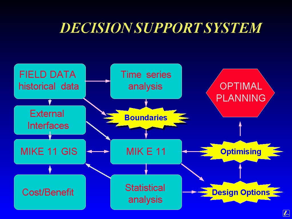
figure 1 The MIKE 11 Decision Support System Framework
Incorporating MIKE 11's capabilities in a DSS allow for analysis of the full impacts on for example flood extents, flood depths, flood damage of present or future options, i.e. "WHAT IF" scenarios can be modeled accurately and confidently. Flood damage assessment from a cost/benefit analysis can also be linked to an optimization module. The optimization module allows for investigating different strategies for alleviating and diverting floods. At all stages of the integrated process model results can be presented to decision makers in a clear and easily understandable formats.
Linking the MIKE 11 hydraulic model with the ArcView GIS merges MIKE 11 and GIS technologies within a DSS Framework. The MIKE 11 GIS interface allows for presentation of flood inundation maps, flood impact maps and related statistics. It has the potential to assist in clarifying and disseminating information through enhanced mapping of impacts on flood levels, communities, agriculture, fisheries and the environment.
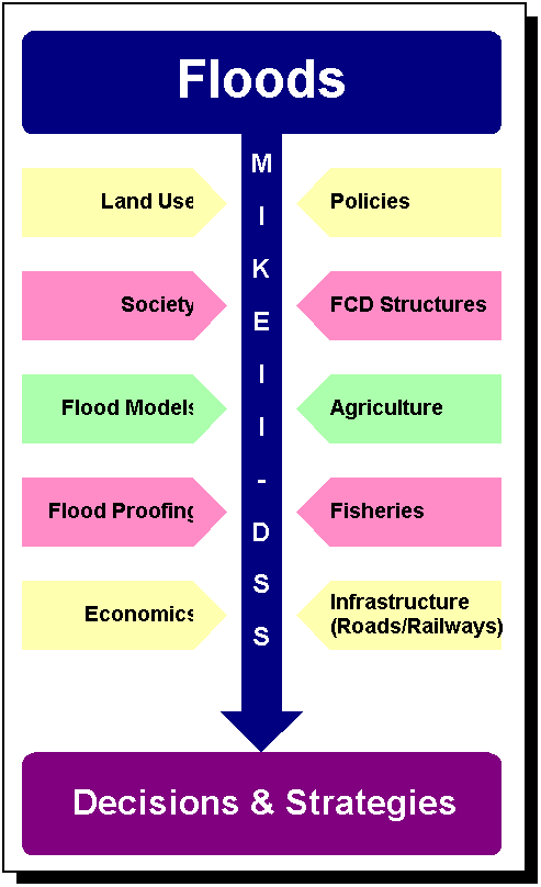
figure 2 MIKE 11 Flood Management
Flood maps illustrates the results from a MIKE 11 simulation in an easily assimilated and highly visual format, highly facilitating interpretation and analysis of potential impacts. Several flood maps can be merged into a video, which animates to an example the development of flood inundation during a flood event. The outputs are high quality presentations which are readily suited to Environmental Impact Assessments, Flood Risk analyses, Flood Damage and Disaster Assessments.
Flood management follows a cyclic pattern linking ideas, proposals, consultations, adopting proposals, preparing guidelines, design, construction/implementation, and operating and maintaining finished schemes. This is the flood management planning, design, implementation and operation cycle, in which MIKE 11 GIS plays a useful role. At the planning level MIKE 11 GIS helps in assessing proposed flood mitigation options and preparing environmental impact assessments.
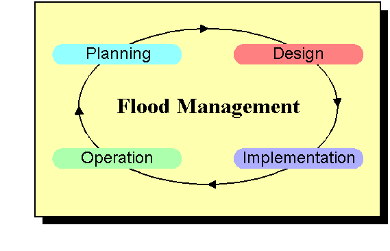
figure 3 MIKE 11 Flood Management Cycle
For design, MIKE 11 GIS functions as a tool for determining civil works design criteria, designing flood control and drainage (FCD) structure operation rules, and providing inputs to flood preparedness programs.
At the implementation stage, MIKE 11 GIS may be useful for a range of needs from scheduling flood prone construction works to a flood preparedness training aid.
Real-time MIKE 11 GIS operation linked with flood forecasting would help guide FCD structure operators and assists emergency relief operations. MIKE 11 GIS also helps present the consequences on flooding due to repair and maintenance of FCD structures. Flood management planning projects may range from flood preparedness programs to major civil works. To help plan projects, MIKE 11 GIS is an effective planning decision support tool.
MIKE 11 is a professional engineering software package for the simulation of flows, water quality and sediment transport in estuaries, rivers, irrigation systems, channels and other water bodies.
It is a fully dynamic, user-friendly, one-dimensional modeling tool for the detailed design, management and operation of both simple and complex river and channel systems. MIKE 11 provides a complete and effective design environment for engineering, water resources, water quality management and planning applications.
MIKE 11 includes basic modules for:
- Hydrology.
- Hydrodynamics.
- Advection-dispersion and cohesive sediment transport.
- Water quality.
- Non-cohesive sediment transport.
Add-on modules are available for most of these basic modules. The modular structure offers great flexibility:
- Each module can be handled separately.
- Data transfer between modules is automatic.
- Coupling of physical processes (river morphology, sediment resuspension-water quality) is facilitated.
- Implementation of new developments (modules) is rapid.
The main data inputs to MIKE 11 GIS are MIKE 11 model networks and MIKE 11 simulation results, GIS themes, one or more Digital Elevation Model's (DEM), and, if available, imagery from satellites or aerial photography.
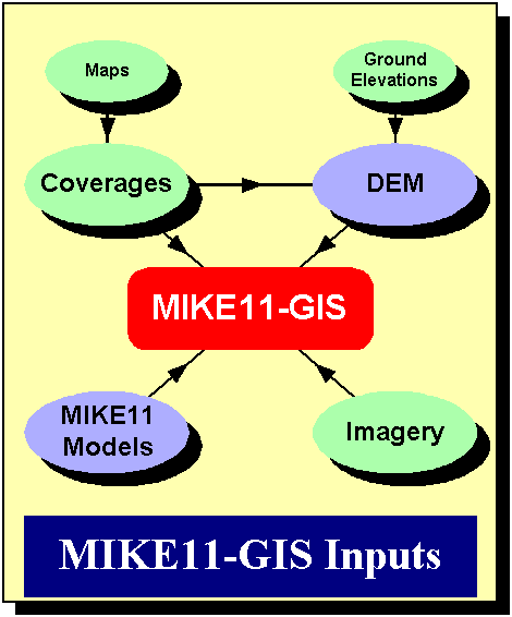
figure 4 MIKE 11 GIS Input
Themes are displayed on the computer screen to graphically show features over the flood plain. Examples are rivers, roads, embankments, villages and lakes. Forethought should be given before the study commences to the types of themes which would be useful. Themes are also used to incorporate the features they represent into the DEM.
The quality of the DEM is fundamental to the quality of the MIKE 11 GIS output. A well prepared DEM is necessary for visualizing the flood plain topography on the computer screen, and most importantly, accurate flood mapping.
If imagery from satellites or aerial photography is available, it may also be displayed on the computer screen for visualizing the rivers and flood plains and for spatial data analysis.
The main data output from MIKE 11 GIS are flood maps, graphs of flood levels, terrain and flood level profiles, flood inundation statistics and flood plain topographic data.
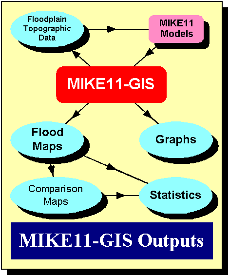
figure 5 MIKE 11 GIS Output
The MIKE 11 GIS topographical module allows the hydraulic model developer to extract flood plain topography easily and accurately (flood plain cross-sections and flooded area versus elevation relations) from the DEM.
Flood plain cross-section profiles are extracted and exported to a MIKE 11 cross-section database. The profiles can also be merged with MIKE 11 river profiles. Flooded area versus elevation curves are computed to quantify the storage capacity of sections of the flood plain, and are also exported to a MIKE 11 cross-section database.
The MIKE 11 GIS FM main outputs are flood maps, an ideal media for visualizing and understanding flooding, and for analyzing flood impacts on other sectors because of interventions. The types of flood maps are: flood depth maps and duration depth maps. Comparison maps, which compare two flood maps of the same type, show the impact from flood interventions or the change in flooding over time. Flood maps and comparison maps can be used by other sectors for flood damage mapping.
Statistics can be output in tabular format to summarize any flood or comparison map. The output comprises to an example areas of inundation for different flood depths. Statistics can be produced for the whole map or for different zones.
Flood level time-series and Terrain/Flood level profiles can also be output to supplement the flood and comparison maps.
The Standard ArcView Project GUI button bar in the MIKE 11 GIS interface has been customized to include a number of new functions.
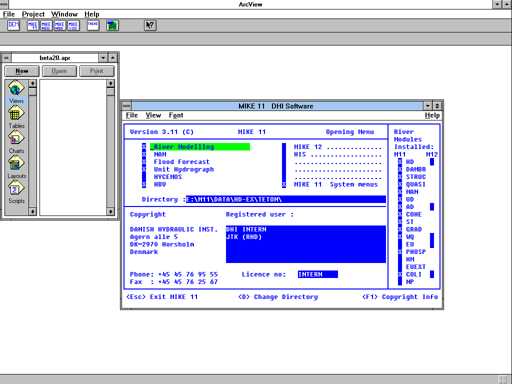
figure 6 MIKE 11 GIS Project GUI
The "DEM" button opens a view allowing for enhanced editing and generation of a DEM. The functionality of the DEM View is described below.
The "MIKE 11" button allows the user to start the MIKE 11 numerical model from within ArcView.
Paths to various MIKE 11 output are specified in the "MIKE 11 MDD", "MIKE 11 MSD" and "MIKE 11 XSD" buttons. The MIKE 11 output is required to develop a MIKE 11 GIS application.
Various default information is defined by the user in "Themes"
When the DEM is generated and paths to the MIKE 11 model results are specified the user opens a Flood Map View GUI. The DEM shape file and a DEM image is automatically loaded and displayed as background Themes of the Flood Map View.
The elevations in a DEM are derived from three basic types of topography: flood plains; high ground; and features which depress or raise the flood plain (e.g. rivers, lakes, roads, embankments and settlements). The flood plain is characterized by very flat topography, while high ground is typically steep. The two main types of inputs to a DEM are:
Ground surface elevations. GIS themes depicting flood plain features such as embankments, roads, low-lying areas, urban areas , etc.
GIS themes of embankments, rivers, roads, settlements, lakes, etc. can be used to build these features into a DEM even though no knowledge of elevations may exist. If these features are either flood-free or permanently wet they can be assigned an elevation above the peak flood level or below the minimum flood level. If elevations exist, for example, along a road or along an embankment, then these should be used to replace the existing DEM elevations.
The accuracy of the flood plain elevations in a DEM is the most important consideration. For flood mapping and for extracting flood plain topographic data it is essential that the DEM models the flood plains accurately.
The standard ArcView View GUI have been modified to incorporate facilities for defining, editing and generating a DEM for use in MIKE 11 GIS.
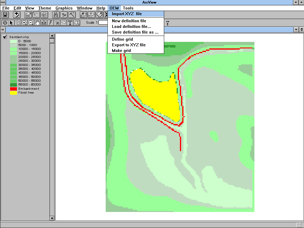
figure 7 MIKE 11 GIS DEM View GUI
The new menu item "DEM" allows the user to set-up parameters for DEM generation. The main parameters required are co-ordinates for lower left corner, grid spacing and number of grid cells in two directions.
Often the basic input ground elevation file with spot XYZ-elevations does not contain detailed level information on important features in the flood plain. These features such as embankments, roads, lakes, urban areas which either raise or depress the flood plain are however very important. Hence these should be incorporated into the final DEM. The menu item "Tools" allows the user to define lines and polygons along which elevations can be defined.
It is advisable to spend time scrutinizing the DEM before applying it for Flood Mapping and Flood Plain Topography extraction as the output is directly dependent on the accuracy of the DEM. So time spent with this process is often well spent.
The Flood Map View GUI is opened from the Project GUI. The menu, button and tool bars of the standard View GUI have been modified to incorporate functions for producing and analyzing flood maps.
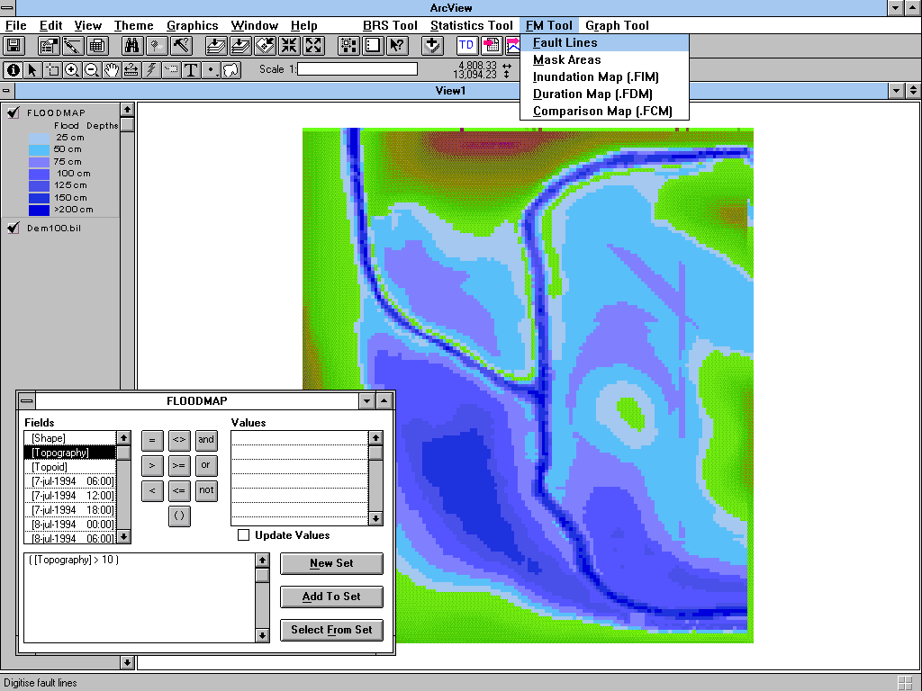
figure 8 MIKE 11 GIS Flood Map View GUI
The menu item "BRS Tool" allows the user to define the Branch Route System. The Branch Route System (BRS) is a network of lines used to geographically locate and display MIKE 11 model features such as branches, structures and computational grid-points. The BRS is an important link for integrating MIKE 11 and GIS data to produce flood maps.
Flood maps are generated from the menu item "FM Tool". MIKE 11 GIS generates and displays Flood Maps using a DEM and MIKE 11 flood simulation results. A specially developed interpolation routine constructs automatically continuous three-dimensional (3D) water surfaces from MIKE 11 output. The water surfaces are compared with DEM ground elevations, producing flood depth maps. The Flood Maps give rapid interpretation and dissemination of flood extent and depths. Comparison maps, which compare two Flood Maps, are a powerful medium for visualizing impacts on flood levels.
The Duration of flooding can also be incorporated using Duration Depth maps. These maps are particularly useful for assessing crop damage based on resistance to Inundation and growth rate. Impacts caused by flood interventions or the changes over time are displayed using Comparison maps. Two Flood Maps are compared and the differences mapped to show the change in flood depths or Duration Depth.
Statistics on areas inundated for different zones can be produced for any flood or Comparison map applying the functions of menu item "Statistics Tool". A table of values is generated showing, for example the areas of Inundation as different depths. Maps can be divided into zones and statistics created for each zone.
From the "Graph Tool" menu item MIKE 11 GIS also displays time series of flood level and discharge, longitudinal profiles of terrain and flood level. Results from several simulations can be compared on the same graph for assessing impacts on flood levels and discharges.
The Topographic Data View GUI is opened from the Flood Map View GUI. The menu of the standard View GUI has been modified to incorporate functions for extracting flood plain topographic data.
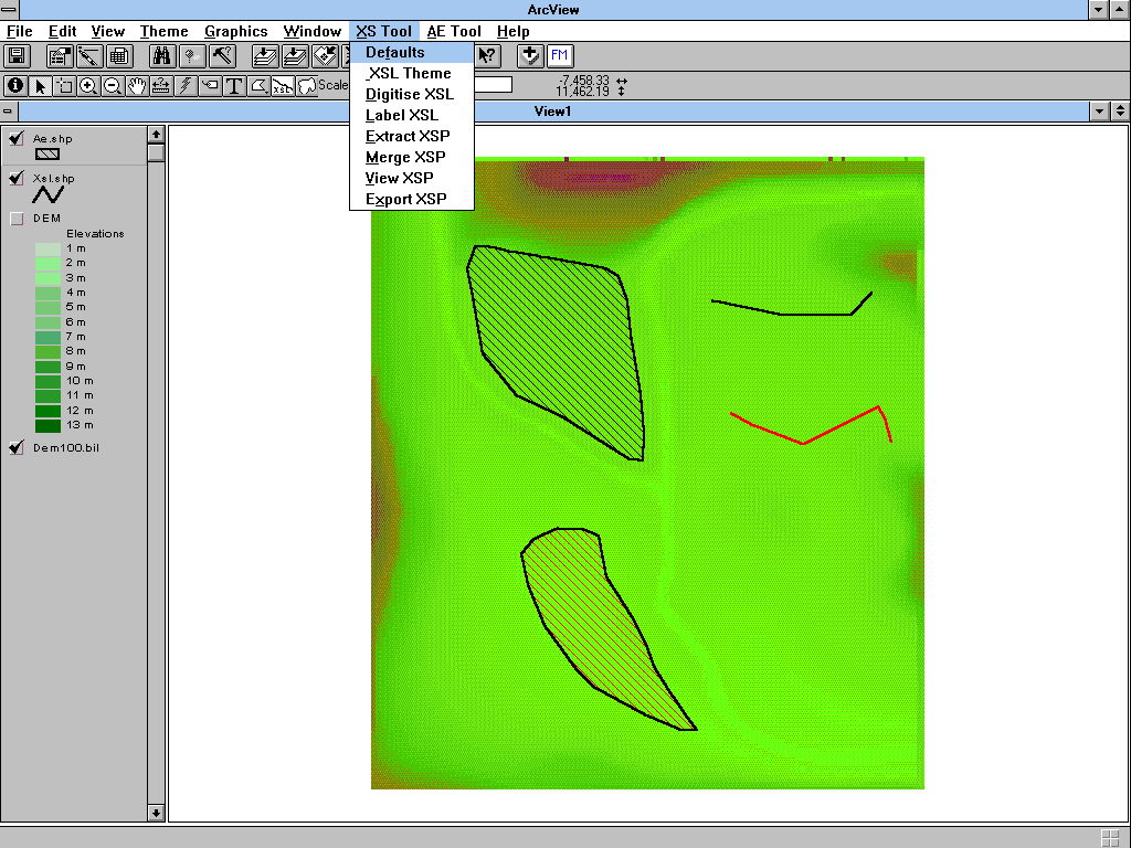
figure 9 MIKE 11 GIS Topographic Data View GUI
Cross-section profiles are extracted using the functions under menu item "XS Tool". In a flood model they describe the river and flood plain topography. Profiles originate from field surveys, hydrographic surveys, topographic maps and other sources. Incorporating them is a major component of flood model development.
DEM's contain a wealth of topographic data over the flood plains. They are an ideal source for flood plain cross-section profiles.
MIKE 11 GIS extracts cross section profiles from a DEM and exports them to the MIKE 11 hydraulic model. Using the graphical interface the alignments of cross section profiles are digitized as a polyline . DEM cross section profiles along digitized lines are extracted and viewed, then exported.
Flooded area versus elevation curves are extracted using the functions under menu item "AE Tool". They are applied in a hydraulic model to describe the storage capacity of flood plains.
MIKE 11 GIS computes Flooded area versus elevation curves from the DEM for user-defined polygons. When extracted the curves can be viewed and exported to the MIKE 11 Model.
The influence of large flood plains on attenuating flooding (or the lack of influence because of embankments) is an important aspect of flood modeling and flood management. To model the influence of flood plains, their storage capacity must be quantified and built into the MIKE 11 flood model.
The Province of Gelderland is located in the eastern part of the Netherlands. Two major rivers flow through Gelderland. These are the Rhine and the Maas.
The purpose of the modeling study was to develop an integrated Disaster Management Tool for the Province of Gelderland on a feasibility level applying the MIKE 11 DSS. In January 1995 the province experienced a severe storm which caused the embankments protecting the polder areas to breach. The failing embankments allowed flood waves to propagate into the polder flooding the low-lying polder areas causing vast damage to large parts of the entire province.
A MIKE 11 model was developed to simulate the complex flows in the polder. The flow paths inside the polder are often undefined, regulated and obstructed by secondary embankments and infrastructure. Information on flood plain topography required to develop the Quasi 2-D flood model was extracted from a Digital Elevation Model (DEM) using the MIKE 11 GIS interface.
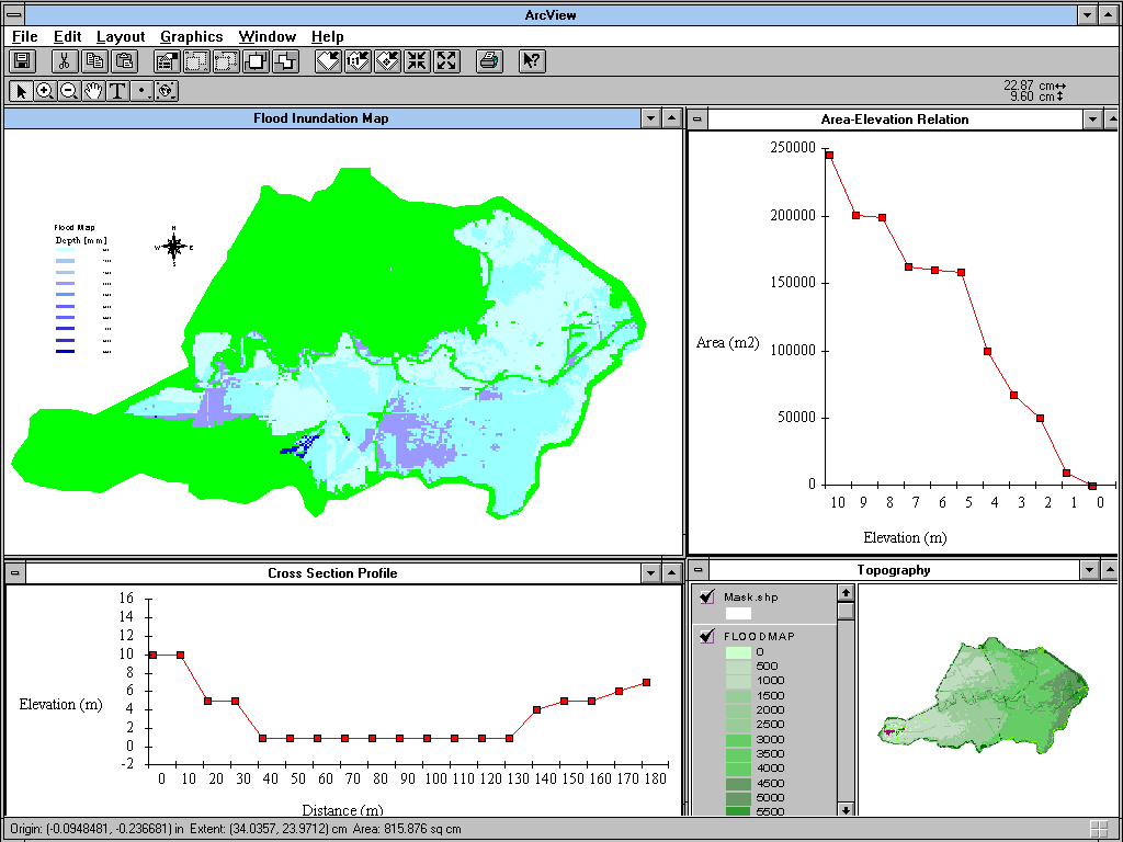
figure 10 Application of the MIKE 11 DSS
Applying the developed flood model various high flow and embankment breach scenarios were modeled. The results were subsequently analyzed as flood maps and as video animation's to visualize the flood wave propagation.
MIKE 11 User and Reference Manual, DHI 1995
MIKE 11 GIS User Manual, DHI 1995
MacMurray H.L., Barnett A.G., Wallace P.L. (1991) Urban Flood Modelling involving Failure of Protective Works, Study of Streams and Watersheds of High HydraulicIrregularity, pp A-691 - A700 Proceedings XXIV IAHR Congress, 9-13 September, 1991
Sørensen H. R., Kjelds J.T., Deckers F., Waardenburg F. (1996) Application of GIS in hydrologic and hydraulic modelling. HYDRO GIS'96, 1996, Vienna, Austria.
Syme W.J., McColm G.a. (1990) Integration of Numerical Flood Modelling into Geographic Information Systems, Conference on Hydraulics in Civil Engineering, 1990, Sydney, Australia
Syme W.J., Barnett A.G., Turton G.B., GIS Floodplain Management. ITMG Conference, New Zealand, Oct. 1992
Verwey A., K. Havnoe, J. C. Refsgaard, Flood modelling in Bangladesh. International Seminar on Hydrology of Extremes (Floods and Low Flows), Roorkee, December 1-3, 1988