The Texas Legislative Council (TLC) has developed a GIS application using ArcInfo for the redistricting projects in the State of Texas. Three main applications have been written to accomplish this task: Redistricting Application (Red Appl), Boundary Definition System (BDS), and Spatial Integrated Cartographic Environment (SPICE). These application programs have been written using a combination of AML and C code. Red Appl is used to assist legislators and their staffs to create house, senate, congressional, State Board of Education, and judicial districts based on TIGER, U.S. census, and election data. BDS is a user interface system used by the GIS specialist at the TLC to create and update cartographic databases primarily for precinct coverages, voter tabulation districts (VTDs), and updates to school district boundaries. SPICE is the main menu-driven application for producing large numbers of maps. The SPICE menu system allows operators to choose a specific map for production and customize which features to show based on the needs of the request. This paper discusses how each application is used in the GIS application process for redistricting.
                         INTRODUCTION


     The decennial federal census, originally conceived as a

method for ensuring equal representation among the states in the

congress,  is the basis for political reapportionment.  Redistricting

processeses must follow the "one person, one vote" principle and

"must make a good faith effort to achieve precise mathematical

equality."  The states must defend even minimal exceptions,

showing why better precision is unattainable by use of the best

available data.    The Texas Constitution requires that

reapportionment be based on the population of the state "as

ascertained by the most recent United States Census,"  and  soon

after its publication (Texas Constitution, 1876).   Every

redistricting plan is subject to the provisions of the Voting Rights

Act of 1965, requiring pre-clearance by the U.S. Department of

Justice.  The complexity of meeting various levels of governmental

requirements necessitates a need to develop an automated system in

order to aid users in their decision-making process.  The Texas

Legislative Council (TLC) has developed a Geographic Information

System (GIS) application to fulfill this need.  The purpose of this

paper is to: (a) discuss the requirements for redistricting; (b)

describe and discuss the redistricting and adjunct applications; and

(c) show how a geographic information system successfully

supports redistricting and cartographic needs.


     The TLC is an agency dedicated to providing professional,

nonpartisan service and support to the Texas Legislature (Texas

Legislative Council, 1990).  A major part of its activity is dedicated

to drafting legislation.  It was clear that if the state's redistricting

solutions were to come from the Texas Legislature and not from

courts or others, that the TLC must provide the legislature with a

successful system that could provide the needed modeling and

reporting capabilities.


Requirements for Redistricting


     Although protection from the passage of any legislation

abrogating a citizen's right to equal protection (including the right

to vote) is elucidated in the 14th and 15th amendments to the U.S.

Constitution, it was probably not until 1962 (Baker v. Carr, 1962)

that a federal court found reapportionment justifiable with respect

to those protections (one person, one vote).  A chronology of

events since that time would include passage of the Voting Rights

Act and numerous legal rulings which would easily fill a textbook.

The current discussion is about the technical constraints.  The states

must show that any deviation from a normal district size is

defensible, either for some pragmatic reason (geography was one)

or, because given the best available data, a better solution was

unattainable.  In addition, the states must also meet the Voting

Rights Act guidelines.


     Contending players must have easily attained access to the data,

which provide the common ground on which solutions are built.

The GIS system must be capable of tracking client activity without

compromising confidentiality,  making it possible to archive and

retrieve historical versions of  redistricting plans and data as

needed.  It must also have a reporting and cartographic capability

that would facilitate the pre-clearance process.  Figure 1 shows the

agencies involved in the redistricting process.
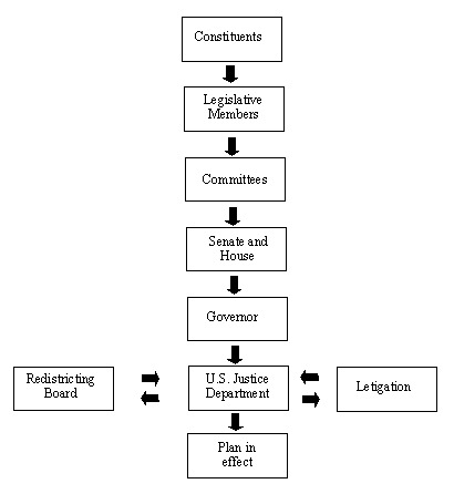
Figure 1: General flow chart for the redistricting process in Texas.


     The current GIS platform in use at the TLC consists of a

local area network network of 12 Hewlett-Packard series 300/400

workstations running HP-UX using ArcInfo as the main GIS

application software.  Twenty gigabytes of storage space is

available for redistricting data and application software.  Large

format map output is produced on an electrostatic E-size Calcomp

plotter and two HP PaintJet plotters for 11-inch by 17-inch maps.

Each workstation is also equipped with an HP laserjet printer for

8.5-inch by 11-inch as well as 8.5-inch by-14 inch black and white maps.

The GIS platform is also networked to the TLC mainframe for transfer

and storage of additional census data as well as access to other

mainframe applications.  U.S. census data serves as the main source

for all base maps and analysis.  The GIS platform is currently being

upgraded to a HP K-200 (server) and J-200 series workstations

with an additional 12 gigabytes of storage capacity as well as a HP

755cm plotter for improved map output.  The system is also currently

in migration to version 7.0.4 of ArcInfo.  These upgrades are

planned to be in use well before the next legislative session in

January 1997.


                      APPLICATION SYSTEMS


Boundary Definition System


     The Boundary Definition System (BDS) is a GIS application

developed in a UNIX environment using ArcInfo.   The purpose

of this application system is to provide the TLC staff the ability to

create or change the geographic boundaries of different types of

working coverages (i.e., adjusting precinct and Voting Tabulation

District (VTD) boundaries as a result of changes in precinct lines

made by individual counties).  The system mainly uses Arc, Arcedit,

Arcplot, and INFO to perform the necessary tasks. The system was

designed so that it can be easily modified and prepared for use with

other geographic datasets as needed, such as school districts,

municipal utility districts, water districts, etc.


     BDS is divided into three main functions:

     (1)  The Add Arcs module which allows a user to add an arc

     into an existing working coverage by extracting an arc from

     a background coverage or drawing a line;

     (2)  The Assign Polygons module which allows a user to

     assign a polygon block to a specific unit such as a precinct

     or school district.  Additionally, this subsystem provides

     several methods for changing district numbers;

     (3)  The Additional Operations module provides the user

     the opportunity to run reports, dissolve working coverages,

     and to run a process called VTDSNAP for automatically

     adjusting any VTD.


     A client uses these modules to create a new VTD coverage.

The process that the clients uses is outlined below:

     (1)  create a new precinct working coverage from a census

     block coverage;

     (2)  dissolve the working coverage on a precinct number;

     and

     (3)  do a VTDSNAP on the dissolved precinct coverage.


     This VTDSNAP process provides the ability to

automatically adjust (snap) precinct lines within the working

coverage.  The purpose of this operation is to make VTD lines

follow census blocks, which is not necessarily true with precinct

lines.  VTD lines essentially follow precinct boundaries as long as

these boundaries follow block lines.  Therefore, if a precinct line

follows a nonblock feature, then the VTD line must be "snapped" to

the nearest block boundary.  The entire block will be assigned to

the VTD district that currently has the largest area of the block.


     After the client has finished making precinct assignments,

the working coverage must be dissolved on precinct numbers.  This

will remove lines between polygons that have the same assignment

leaving a single polygon for each contiguous precinct.  During the

dissolve process, the following reports are produced to assist the

client in determining that all precincts have been assigned correctly:

     (1)  Missing geography -  detects unassigned geography;

     (2)  Noncontiguous polygons - detects island polygons;

     (3)  List - creates a general list of all units;

     (4)  Splits - shows any units split by district lines; and

     (5)  Changes - shows any units changed between the

     previous and new precinct coverage.


     An additional check is made to determine if the precincts are

correct.  Since the TLC works with two separate precinct

databases, a check between the two databases is made.  One

database is maintained in the Texas Election Database (TED), a

mainframe application used by the redistricting staff, which consists of

tables of election information reported by precinct.  The staff

receives election data, and the associated precincts from counties,

and enters this info into TED.  The other database is maintained in

BDS.   Both databases agree so that election information can be

allocated to VTDs.  This check involves writing the BDS precincts

to a UNIX text file.  This text file is sent to the mainframe where

the actual comparison is completed and which generates a report

detailing any discrepancies.


     After the precinct production coverage has been created,

the precincts must be snapped to block lines.  When the VTDSNAP

is completed, the same reports that are produced for the dissolving

of precincts are generated to assist the client in determining that the

VTDs have been snapped correctly.  In addition, another process is

initiated to send the VTDs and their corresponding precincts to the

mainframe where election data is allocated from precincts to their

respective VTDs.  After the allocation of election information to

VTDs, the VTDs and their respective election information is sent

back to the GIS system and used in the Redistricting Application

system.


Redistricting Application System


     The Redistricting Application (Red Appl) system is a

graphical GIS system developed to assist legislators and their

designees to create house, senate, congressional, State Board of

Education, and judicial districts by graphically displaying

geographic, population, and election data.  The Red Appl system

was developed using ArcInfo,  UNIX shell scripts, X windows,

and C programs.  It mainly uses Arcplot, INFO, and Librarian

modules of ArcInfo.  Geographic features such as county

boundaries, tracts, and blocks are taken from TIGER

(Topologically Integrated Geographic Encoding and Referencing)

data provided by the U.S. Census Bureau.  Population data is also

provided by the census bureau.  Election data is maintained by the

redistricting staff using TED and BDS applications.


     In addition to Red Appl, the Population Analysis System

(PAS), a nongraphical, IBM mainframe application, exists to assist

redistricting clients (any member of the legislature or any group

sponsored by the legislature) to create district plans.  Due to the

limited number of workstations and a large client base, PAS tends

to be used as a sister system to Red Appl.  The PAS system does

not provide all the functionality that Red Appl provides.  Clients

can only create districts from VTDs and counties and does not

provide a graphical interface.  However, it does provide the client

base more access to redistricting information since every client has

access to mainframe applications and every client does not have a

workstation.  The client can begin creating a plan (a proposal for

dividing the state into districts) by assigning districts at their

respective offices using the PAS system.  The client can then

transfer this plan to the Red Appl system and use one of the limited

number of workstations to assign districts at a much more detailed

level of geography using a graphical GIS interface.


     Administration, plan manipulation, and modeling are the main modules

to Red Appl.  Administrative functions include copying plans between

clients (interclient),  authorizing new client accounts, making plans

public, merging two plans,  sending a plan to the mainframe for a more

in-depth population analysis report using the PAR system on the mainframe,

producing a contiguity report,  producing an unassigned geography

report, and dissolving a plan for mapping.  Plan manipulation includes all

functions that manipulate a client's plan other than the actual

assignment of geography (such as copying a plan intraclient),

marking a plan for deletion, creating a new plan, viewing/adding

comments, editing a plan's description, renumbering districts,

copying a county, recalculating  population statistics for a plan, and

generating reports on contiguity, unassigned geography, and

incumbents, as well as producing a simple population analysis

report.  Modeling incorporates viewing graphical and nongraphical

population data, election data, and geographic features in order to

assist in the adding/removing of geographic units to a particular

plan.  It also provides the client the opportunity to choose the level

of geography for modeling.  In modeling, the client can add/remove

multiple units of contiguous or noncontiguous unfrozen units of

geography or display information about a selected unit of

geography.  After the client has assigned a polygon to a district, the

client can freeze this assignment.  Therefore, when the client wants

to unassign a group of geography, the client will be informed that

the client has selected one of the districts that cannot be changed.


     Types of data and geography used by the Red Appl system are:

     (1) Census geography - blocks, block groups, and counties;

     (2) Election geography - Voting Tabulation Districts;

     (3) Election returns;

     (4) Census population statistics - total population, age

     population, minority total population, minority voting age

     population, and noncitizen voting age population.


     Each district in a plan that is drawn by a redistricting client

must comply with the following criteria:

     (1) follow a block boundary line;

     (2) be contiguous;

     (3) have a population that is close  to the population of all

     other districts in the plan; and

     (4) not have minority population that will have the effect of

     discriminating against the minority group.


     In order to assist the client in meeting the above criteria for

a district composition, population statistics are tracked and are

reported both on the screen and as hard copy output by Red Appl

and the Population Analysis Report (PAR) system.  PAR is a

mainframe application that provides detailed reports about a plan's

demographics.  In addition to the population information, election

information can be reported for a plan to assist the client in drawing

districts.  However, election information is reported by precinct and

does not necessarily follow block lines.  Since all district lines must

follow a block boundary, the precinct lines must be adjusted to

follow block lines and election data must be allocated from

precincts to the VTD level of geography, which are then allocated

to all other levels of geography.  The population information and

election information can also be used to shade the level of

geography on the screen.


     Since a district line must follow a block boundary line, all

levels of geography (i.e., block, VTD, county, tract, and block

group) that a client can use to draw districts must follow block

lines.   All these levels of geography follow block lines, therefore,

they do not have to be adjusted.  The population for these levels of

geography are reported at one of the levels of geography and have

to be allocated to the other levels.  For example, if population is

reported at the block level, it will be allocated to the other levels of

geography (i.e., county, VTD, tract, and block group).  The Red

Appl system also provides reports about contiguity and unassigned

geography, since all geography must be assigned and all districts

must be contiguous.  Figure 2 illustrates the hierarchy of the

different levels of geography that a client can use in creating

districts.
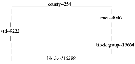
Figure 2:  Hierarchial structure of geography for creating districts.


     Most of the programs are written in AML, however, some

C programming and UNIX shell scripts are incorporated in order to

speed up the system and compress the files.  In order to preserve

disk space, the plan file with district  assignments is packed at the

block level using a run length encoding process.  The pack and

unpack routines are used when the client changes from one level of

geography to another and when the client enters or exits modeling.


     Unpack means taking a packed plan file, uncompressing it,

and expanding it to the level of geography at which the client wants

to model.  Pack means  taking an unpacked plan file, expanding it

to the block level, and compressing  it.  Compress means taking an

unpacked plan at the block level, and compacting it using a district

compression routine written  in-house.  Uncompress means taking a

packed plan file and enlarging it to the block level.  The unpacked

UNIX plan file is externaled to an INFO file.  This INFO file keeps

track of the district assignments and shading of districts while a

client is creating districts.


     When a client wants a map produced of the plan using the

automated mapping system, an operator must dissolve the plan.

Since up to this point the plan is only a file used for shading the

districts and is not a coverage, the statewide VTD coverage must

be dissolved on district numbers in the plan file.  This statewide

dissolved coverage is the statewide VTD district coverage.


     If a county is split at a level of geography other than the

VTD level, the county block coverage must be dissolved on district

numbers in the plan file.  Each county that is dissolved at the block

level is joined.  This joined coverage is used to update the VTD

coverage in order to create the statewide district block coverage.

In addition to the statewide coverages, each county that is split at

any level of geography has a coverage created as well.  After the

dissolve process, ArcInfo coverages are available for use in the

mapping applications.


Spatial Plotting and Integrated Cartographic Environment


     The Spatial Plotting and Integrated Cartographic

Environment (SPICE) is a map-plotting application that makes

extensive use of  Arcplot.  It was originally made available to users

at the TLC in 1992.  An improved version became available in

1993-1994 and enhancements have been added since then.


     The need for a standardized plotting system originated with

the needs of the client base.  The first and most important purpose

of the system was to have at hand a capability for producing

demographic maps and maps that show political geography quickly

and accurately (Burrough, 1986; Goodchild and Kemp, 1990;

Huxhold, 1990).  Not only would the maps be needed as working

papers for our clients, but they would be used for submitting

redistricting plans for pre-clearance by the U. S. Department of

Justice in the Voting Rights Act.  It was recognized that since there

would almost certainly be litigation, the courts, justice department,

and the redistricting players would be best served if they could

share common resources (including those associated with printing maps

and reports) and data.  It was expected that the GIS technical

support would also prove useful for projects other than

redistricting, therefore, the system had to have the capability for

extensions to cartographic support for other projects as well; this

was a distinction made between routine (redistricting) and special

(all other) requests.  The routine requests would be fully classed,

but a programming standard would be that the system not be

limited to its original vision, therefore, designed to accommodate

new kinds of  requests.  Since its first use in 1992, it has processed

a hundred routine requests and about twice as many special requests.


     The SPICE system is a menu-driven mapping application

designed to produce a wide variety of maps in quantity, in such a

way that there is a consistent treatment of the content from one

page to the next, and so that the same map will be easily

reproducible years into the future.  In its current version, the menu

system is constructed from X-intrinsic "widgets," built around a

core of C programs that mediate a dialogue in which system values

and small files are built that will provide the particulars about the

content of the map.  In the Arc environment, there is a collection of

AML macros that accepts the parameters and generates the map.

One macro sets up the page layout, another prints the titles and a

logo, another handles coverages and data naming conventions,

another adds the map content and builds a legend, others control

text styles and fonts, and so on.  This modular approach has given

the system the flexibility it needs, while providing stylistic

consistency and providing the capability for handling the special

requests.


     The model is a semantic system in which there are basic

themes that have characteristics that can determine the map.  For

example, a mapping AML called "red500,"  routine request ("red"),

generates a map of  political districts ("500" indicates that the map

will contain a redistricting plan).  A redistricting plan is a universe

of polygons (districts) that are mappable at the extent of the state,

of an individual county, an inset of a county, a city, and so on.  In

this system, then, "red500.aml" will contain options that will permit

the user to specify a map extent based on one of those places.  The

AML presents the users with options to map a redistricting plan as

a type DS (district), STATE (the entire state), C1 (a plan within a

county), and so on.  Selecting "C1" (by clicking on a button)

displays a menu that allows the user to build a list of counties (each

page will be a map of a county); selecting "DS" instead causes the

user to display a list of districts to choose from, and each page is a

map whose extent is that of an individual district.


     The first major departure from the so-called RED

(redistricting, routine request) maps were those associated with

school funding.  This was a focus of legislative activity in 1993 and

1995, and led to the creation of an SDI series of maps that

presented econometric data supplied by the Texas Education

Agency in much the same manner as the thematic presentation in

the redistricting maps.


     At this time (March 1996)  the map groups are:


     Map type

     RED - associated with routine redistricting requests

     SDI - school districts, school funding

     JUD - judicial redistricting

     SPE - special request maps

     TLC - in-house data verification


     Map Class

     000 - 099 census geography or other spatial information but

               no thematic content

     200 - 299 census geography, with a population theme by thematic

               shading

     300 - 399 census geography with an election result by thematic

               shading

     500 - 599 a redistricting plan with no thematic content

     600 - 699 redistricting plan, with a population theme

     700 - 799 redistricting plan, with an election result as thematic

               content

     800 - 899 maps showing two or more plans simultaneously.


     Important features of this system include that the AMLs

containing the core functionality are useful in several contexts, and

the use of recursion and modularity are the standard.  This permits

the creation of batch processes that will produce a complete set of

maps from one invocation of the system.   For example, one of the

processes,  "red599," permits users to specify a "plan packet,"

which spawns a subprocess that will unpack a client plan from the

Red Appl system, generate a list of counties needed to make a

complete set of maps, determine which will require a full page and

which can be placed in  a four-per-page layout (generally, the rural

counties), and print the entire package by repeatedly invoking

variants of another AML, "red595."  In this example, there are

several versions of a plan packet: one that provides city limits;

another zip code areas;  and a third, voting precincts.  This obviates

any concern for operator error, especially important during a

waning legislative session when there is a peak of activity and fast

publication is essential.


       The maps are distributed to clients and the general public

through the redistricting library at the TLC.  In the interest of

facilitating public access to the data, routine requests are available

to the general public at cost (this includes a very inexpensive but

complete presentation on legal-size, monochrome plan packets that

are optimized for easy photocopying).  There is a vision of

extending public access through the internet in the near future (a

"
 server"), but also a recognition that there will still be a need

for access to hardcopy, for the foreseeable future.


Boundary Block Suggestion Project


     The Block Boundary Suggestion Project (BBSP) provides a

forum for states to "suggest" census features to be held as block

boundaries for the 2000 census.  Working with procedures and data

from the U.S. Census Bureau, the participants will select census

features to define census block boundaries which will most benefit

their states to create voting precincts and legislative districts.


     The TLC has been chosen to be the participant for the State

of Texas.  A GIS application has been written to help the council

complete this project.  The data from the census bureau to be used

is the 1995 TIGER/Line files specifically created for BBSP.  The

files will be converted to ArcInfo coverages using a program

created by Esri called TIGERTOOL94.  After conversion, the

coverages will have two new important items in the AAT:

BBSPCEN and BBSPPART.


     The BBSPCEN item has three possible values and are set by

the census bureau.  A value of 4 means the arc is guaranteed to be

held as a census block boundary.  A value of 2 means the arc

cannot be held as a census block boundary.  A value of 0 means the

arc has not been flagged by the census bureau and the participant

can either leave the arc unflagged, flag as a "must hold," flag as a

"do not hold," or flag as a "contingent hold."  All these choices

made by the participant will be stored in the BBSPPART item.  For

a final output, the census bureau requires an ASCII text file which

includes a state code, a county code, TLID number ( a unique

number the census bureau has assigned to every arc in the U.S.),

and the value of the BBSPPART item.  The file will contain every

arc in that county, not just the ones that were flagged.


     The TLC wants to ensure that the boundaries that make up

voting precincts and legislative districts are held as census block

boundaries.  This will ensure that VTDs will be able to represent

precincts as closely as possible.  It was determined that a process

was to be created to automatically match as many of these

precinct/district arcs to BBSP arcs as possible.  An automatic

matching process would save an incredible amount of time in

determining which arcs are to be held.


     The automatch process is a very important step in the pre-processing

of the data for the application.  The precinct/district coverages were

originally created by 1990 TIGER/Line files, so they match up with the

BBSP arcs for the most part.  Pseudo nodes had been removed from the

precinct coverages and some additional arcs had been added when

precinct lines did not follow census features.  The goal was to match the

coverages (node-to-node and arc-to-arc) as much as possible so a

MATCHCOVER command could be executed.


     To accomplish this, the precinct/district coverages were

unioned with the BBSP coverage.  The results of the union had the

nodes needed from the BBSP coverage and the attributes from the

precinct/district coverages to identify the arcs as precincts or

districts.  The output coverage was dissolved using the

precinct/district items as the dissolve items.  The net option was

used to ensure the arc attribute information remained intact.  The

net option left many arcs in the dissolved coverage that did not

make up a precinct or district boundary which were subsequently

deleted.


     At this point, the manipulated coverage had only the arcs

we originally started with in the precinct/district coverages, except

now nodes were inserted where the coverages were intersected by

BBSP.  This allowed for the closest match, topologically speaking,

for the BBSP and the precinct/district coverages.  The items of both

coverages were made identical, which is required for the

MATCHCOVER to work. The MATCHCOVER is used to transfer

attributes from one coverage to another when the arcs of the two

coverages fall within a given tolerance.  A tolerance too small gives

few matches, not allowing for any variation between the two

coverages.  A tolerance too large gives multiple matches which are

ignored as if nothing matched.  Each county had a different match

rate but all seemed to fall between 90 and 100 percent.


     The important information transferred during the

MATCHCOVER was the TLID value item.  Simply having the

TLID for the arcs to be held was not enough.  It was also important

to know how that the census bureau has flagged those particular

arcs (BBSPCEN).  If the BBSPCEN value was a 4 (Guaranteed

Hold), nothing needed to be done.  If the BBSPCEN value was a 2

(Cannot Hold), an alternative arc would need to be chosen during

manual selection.  If the BBSPCEN value was a 0 (Not Flagged),

the BBSPPART item needed to be flagged as a "must hold."  To

accomplish this, the newest coverage was related to the BBSP

coverage in INFO using the TLID as a common item.  Items were

added to the BBSP coverage to identify all arcs that were precinct

boundaries and, also, which arcs were district boundaries.


     The precinct/district and BBSP coverages are copied to a

county workspace for storage until the operators are ready to work

on them.  The second module is the interface that allows the

operators to manually flag BBSP arcs to be held.  This module is

executed in Arcplot since only attributes are being changed and

allows for easy viewing of many coverages to be used as references

when selecting arcs.  Also, using MAPLIMITS, a locator window

is drawn in the corner of the screen to show which part of the

county is currently being viewed.


     A pop-up menu, with a list of nonmatching arcs, allows the

operator to simply select one of these arcs and zoom in on the

selected area.  As the problems are fixed, the operator updates a

field to show how the fix was accomplished.  The field is updated in

the pop-up menu so that the operator knows which problems have

been fixed, how they were fixed, and wihch problems were left to

work on.  A drawing options menu is available to toggle on/off

features like BBSP arcs, precinct arcs, district arcs, city limit

boundaries, and feature type (CFCC) arctext.  In addition to the

zoom by selection feature, the operator has the ability to move

around the county with features such as window-in, zoom out, pan,

and save/restore mapextent.


     Buttons are available to flag BBSP arcs as "must hold," "do

not hold," and "contingent hold."  Also, an option is available to

return a flagged arc back to the default value set by the census

bureau.  The color of the arcs is updated on the screen to represent

how it has been flagged.  A checker can also use the same

functionality in this module to make sure the operators are making

selections that conform to census bureau procedures and TLC

needs.  The final module is used to create the Equivalency File

which will be sent to the census bureau.  A copy of the BBSP.PAT

is manipulated and used to create an ASCII text file in the form

requested by the census bureau.  These files will be sent over the

Internet to the U.S. Census Bureau Regional Office in Dallas.  This

will complete the first phase of the Block Boundary Suggestion

Project.


                          SUMMARY


     The TLC has developed three main GIS application systems

to assist legislators and their staffs to determine district boundaries

for the State of Texas: BDS - creating and updating cartographic

databases; Red Appl - create and modify district boundaries; SPICE

- automated mapping system.  In addition to these main

applications, BBSP is being used to suggest block boundaries for

the next census in the year 2000.  All these systems are designed to

work in conjunction with one another in order to automate

cartographic, mapping, and analysis work.  These automated

systems have been an invaluable tool over the last few years in

redefining and updating political districts.  These GIS applications

have been a success for redistricting and demonstrate the usefulness

of GIS for applications development in the legislative community.


                       ACKNOWLEDGMENTS


     The authors wish to acknowledge the following people who

have contributed to one or more of these projects: Kelly Clausius,

Todd Giberson, Rai-Ling Lee, and Reginald Warren (original

designers of the Red Appl system); Kirk Divine, Tina Hengst, Carl

Keprta, Shelley Leach, Steven Marquardt, Gregory Samson, and

Robert White (for their work in the SPICE and BDS systems)

Michael Clark, Robert Gatliff, Chris Miles, Thomas Moe, and

James Ting (network and systems support); Tobin Crain, Clare

Dyer, and Gary Grief (block boundary suggestion project);  Greg

Tingle and Tom Hayden (mainframe support), and especially

Debbie Elliott, Alan Ware, and Shane Groves whose patience and

support will not be forgotten; all helped to "put the GIS" into

legislation; and finally to Karen White and Debbie Irvine, whose

creativity and leadership made it all possible.


                         REFERENCES


Baker v Carr, 1962,  369 U.S. 186

Burrough, P.A., 1986, Principles of Geographical Information

     Systems for Land Resource Assessment: Oxford University

     Press, Oxford, 194p.

Constitution of the State of Texas, 1876, Article 3, Sections 26,

     26a, and 28.

Esri, 1992, ArcInfo Technical Manuals: Esri, Inc., Redlands,

     California.

Goodchild, M. F., K. K. Kemp, 1990, NCGIA Core Curriculum:

     National Center for Geographic Information Analysis:

     University of California at Santa Barabara, California.

Huxhold, H.E., 1990, An Introduction to Urban Geographic

     Information Systems: Oxford, Oxford U.K., 337p.

Texas Legislative Council, 1990, Guide To Redistricting,

     Information Report No. 90-1.