China Lake Naval Air Weapons Station (NAWS) in Southern California, in cooperation with the Advanced Resource Technology (ART) Group at the University of Arizona, are in the process of developing a GIS-based decision support system to assist China Lake NAWS in their land use planning and management efforts and to comply to environmental regulations. This paper will describe the development of the China Lake GIS. Two environmental management applications for the endangered and threatened species, Inyo Brown Towhee and Desert Tortoise, will be presented.
Geographic information system (GIS) technology has been increasingly used to assist in the management of natural resources and in making environmental decisions. However, within the military sector GIS applications for natural resource management are not as common. In October, 1994, China Lake Naval Air Weapons Station (NAWS) in California, in cooperation with the Advanced Resource Technology (ART) Group at the University of Arizona initiated a project to develop GIS capabilities for the base through funding from the Department of Defense's Legacy program. The purpose of this cooperative research effort was to assist the land resources management programs at China Lake in natural and cultural resource management and planning through the use of a geographic information system (GIS).
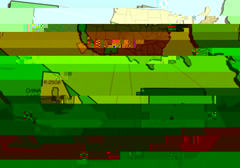
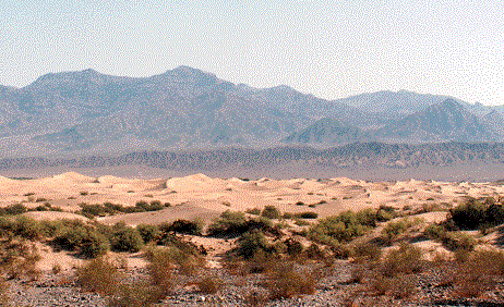
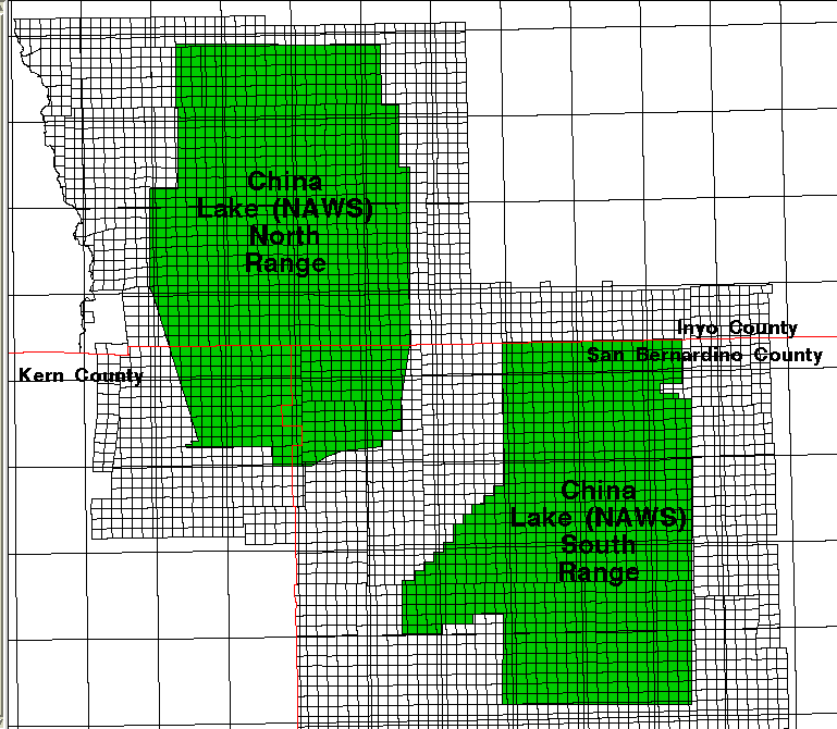
China Lake NAWS (Figure 1) was founded in 1943 and represents the largest Navy land facility holding . China Lake NAWS covers 1,700 square miles and lies east of the Sierra Nevadas (Figure 2) and southwest of Death Valley National Park (Figure 3). China Lake NAWS is divided into two ranges (Figure 4). The base lies within 17,000-square-miles of restricted airspace. The installation was originally known as the Naval Ordinance Test Station (NOTS) and later as the Naval Weapons Center (NWC). Navy-wide consolidation and streamlining efforts in 1992 put this installation within the Naval Air Warfare Center Weapons Division (NAWCWPNS).
The base functions primarily as the Navy's principle research, development, testing and evaluation (RDT&E) site for air-to-air and air-to-ground missiles and weaponry research and development. China Lake activities are guided by a myriad of legislative mandates, including federal legislative mandates concerning the protection of threatened and endangered species. In light of the continuing legislative mandates, China Lake NAWS remains committed to conserving its natural resources through advanced resource management techniques, including the use of geographic information systems (GIS). As a whole, China Lake NAWS desires to test weapons with minimizal environmental impact and make better decisions by integrating information and applying a GIS-based decision support methodology.
China Lake NAWS is recognized for its unique desert ecosystems and an extensive cultural heritage. The base is home for several threatened and endangered species; desert tortoise, Inyo California (brown) towhee, the Mohave ground squirrel and the Mohave Tui chub. China Lake NAWS also contains several rare plant species, a population of desert bighorn sheep and several registered historical sites.
The primary purpose of the China Lake NAWS GIS is to support the military mission on the installation, as well as assist managers comply with environmental regulations and maintain China Lake's excellent record of land stewardship. Secondary issues include developing capabilities to support the planning activities at NAWS. These concerns are not mutually exclusive, requiring many of the same theme layers. To support the military mission at China Lake NAWS the planning, environmental, and natural resources programs must be able to evaluate the potential impacts and constraints for a suite of military activities. From a land management perspective the compatibility (or non-compatibility) of different land areas to different military activities will be delineated. To be most effective and efficient this analysis must be done both spatially and temporally. As an example, for the threatened and endangered species Inyo California (brown) towhee, certain passive (i.e. non- consumptive) activities within their breeding habitat may be off limits during the nesting season but are allowable during the rest the year.
Developing GIS capabilities for China Lake NAWS will require the creation of a GIS database to evaluate potential environmental impacts. Models, criteria, and rules for making impact assessments will be developed. In some cases these "models" will need to be field validated and linked to ongoing inventory and monitoring programs. The GIS models, linked to a monitoring program, will serve as the basis for making future management decisions and allow managers to adapt to changing conditions and priorities.
A commitment to excellence in the management of natural resources was a catalyst for GIS development at China Lake NAWS. The role of China Lake NAWS in maintaining the regional environmental health and biodiversity can be assessed using the GIS. There are indications that military land uses may cause less impact to some types of native flora and fauna and their habitats than other intensive land uses such as livestock grazing and urbanization. Resource conservation efforts applying GIS technologies at military installations like China Lake NAWS offers significant contributions for species management within the region.
One of the first tasks of the project was to identify the information needs for natural resource management. Since China Lake NAWS was just beginning to develop their GIS database they needed basic theme layers such as topography, road systems, buildings, and hydrography. However, after several meetings with NAWS personnel, theme layers were identified specifically for the natural resource GIS database. These coverages included:
Throughout the project, the GIS program has been evolving from a CAD based facilities mapping unit to an integrated system of facilities, infrastructure, and natural resource based data. All data resides on China Lake NAWS IBM-compatible PCs running pcArcInfo and Arcview. The China Lake NAWS GIS currently contains the following thematic layers:
Development of the China Lake GIS required the utilization of many different database development techniques. To date, most of the effort has been in the conversion of data into ArcInfo from other software packages and digitizing historic maps. Data was converted from both AutoCad and MOSS into ArcInfo. A number of problems were encountered during database development, including:
Large amounts of data, in both hardcopy and digital formats, were created by consultants over many years as they were hired for various short-term, non-integrative projects. The deliverables of these projects, such as paper maps, reports, or occasionally digital data were at varying resolutions, projections, and scales. Thematic attributes were often buried in the body of the reports. These problems compounded the need for a system that would integrate the various data sources and aid in feeding decision making processes on the base.
The problems encountered illustrate the need for standards and documentation when creating spatial databases. One of the results of this project will be increased standardization of data collection and reporting procedures at China Lake NAWS. For example, an agreement has been reached to standardize all GIS mapping efforts in UTM meters, zone 11, NAD83. Metadata has been developed for all existing theme layers. AutoCad drawings have been converted to ArcInfo coverages. Individual tile maps have been edgematched. One result of this effort will be the development of a database that has gone through a quality control process.
The Desert Tortoise
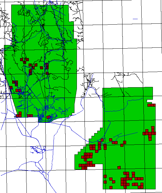
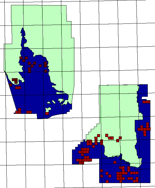
Desert tortoise (Figure 5) information was obtained from a hardcopy of a field study performed by outside consultants. Field transects had referenced locations of tortoise dens, tracks, scat, etc. The ART Group was given a copy of the report furnished by the consultants. Since a digital version of the file was unobtainable, all 12 fields were reentered in a INFO compliant format using Microsoft Access. Township, range, and section fields were used to join the study findings to public land survey system sections. This provided ART with the opportunity to graphically display locations of desert tortoise sightings (Figure 6, red boxes).
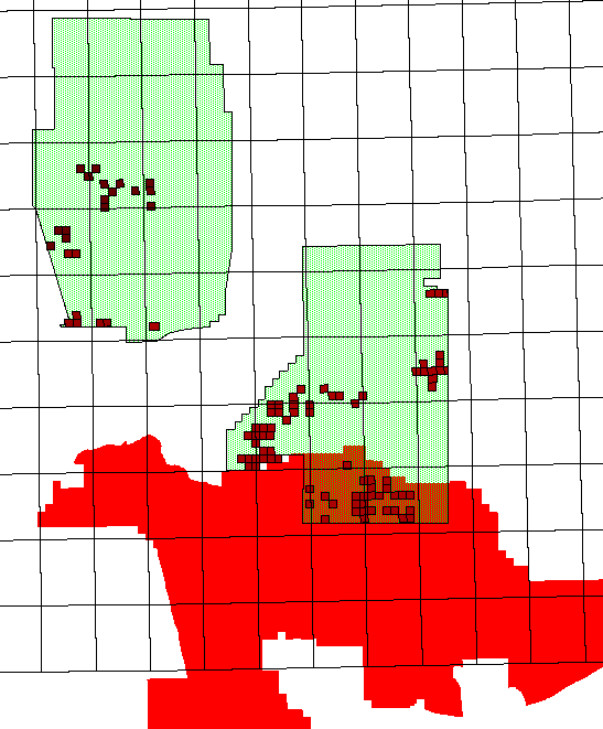
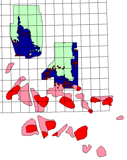
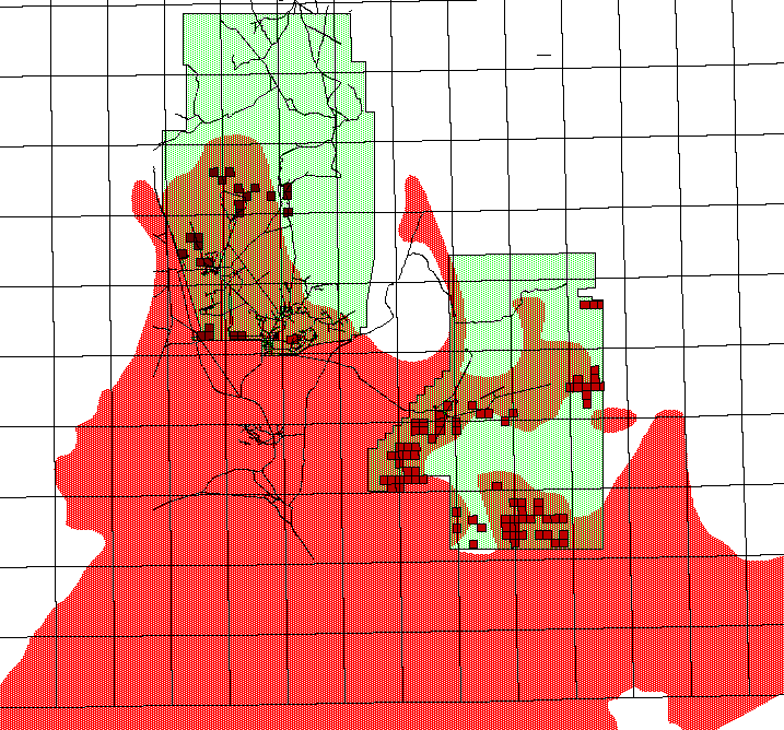
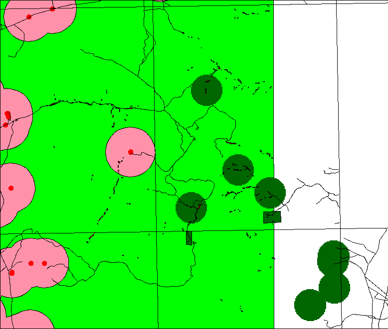
China Lake NAWS has established boundaries for desert tortoise management zones (Figure 7, blue zones). The Bureau of Land Management has also identified critical desert tortoise habitat areas (Figure 8, red zone). Critical habitat has been designated as protected whereas habitat has, for some historical, political, administrative or other reason, not yet be designated as protected. High and medium desert tortoise habitat (Figure 9, pink and red zones) has been designated within the critical habitat areas. The BLM has also define general habitat around and within China Lake NAWS (Figure 10). When China Lake and the BLM's desert tortoise habitat designations are viewed together (Figure 11) their agreement varies. The BLM's designations extend into China Lake NAWS as well as beyond China Lake's boundaries.
Buffered range assets (buffers are all at 5000 feet for demonstration purposes but eventually will be based on activities occurring at that location) and other human impacts can be overlaid with desert tortoise sightings to examine how activities on the base are impacting the desert tortoise . This figure is limited to the north range due to lack of range asset data for the south range. Viewing buffered range assets, desert tortoise sightings, and management zones in unison helps demonstrate how protected areas relate to what has been found on the base as well as the extent of impact current activities have on protected areas.
The California Inyo Brown Towhee
China Lake NAWS has a sizeable population of the threatened California Inyo brown towhee. The towhee (Figure 13) is a grayish brown bird found primarily in Mohave Desert. Today, China Lake NAWS and adjacent BLM lands are its primary refuge. Field biologists delineated potential riparian areas on USGS 7.5 minute quadrangles and field validated them. For those areas that were determined to be riparian areas, a second classification was then made to determine whether they were critical Inyo brown towhee habitat. Mapping efforts were done for only a portion of the north range of the base. Mapped resolution for the towhee was significantly smaller than for the desert tortoise. At times, delineated areas consisted of small polygons only a few meters in width as opposed to desert tortoise activity areas of 1 square mile. Hence, varying species monitoring protocols directly influence the scale and accuracy of the GIS thematic data.
The California Inyo brown towhee is both federally and state listed as a threatened and endangered species. In the past, some field studies and mapping have been geared toward understanding where the Towhee are and what types of areas they are living in. Field data (Figure 14) was drafted onto 7.5 minute USGS quadrangles and used as the information source for digitizing. Basic attributes were attached to the data for future use and FGDC compliant metadata was created. Towhee data examined with buffered range assets and other human impacts such as roads (Figure 15), provides a guide for where activities should and should not occur. This type of data retrieval and analysis is representative of what China Lake NAWS staff will be able to do in order to manage and preserve the maximum amount of habitat and species diversity while meeting their military mission.
The internet has proven to be a valuable tool in the communication between all the cooperators. Information can be quickly transferred between Arizona and California. GIS analysts at Arizona have solved computer-based problems on China Lake NAWS computers. An ArcInfo analysis can be completed in Arizona, imported into Arcview and the Arcview project sent to China Lake NAWS within hours. The only drawback has been that using file transfer protocol (FTP) has proven difficult at times due to the long data transfer time between the University of Arizona and China Lake NAWS network. Another problem is not all the cooperators at China Lake NAWS have internet access. The project has illustrated the potential for advances in communication for efficiently solving problems. However, technical issues must be solved before it can become a truly efficient process.
Future efforts include creating the databases for cultural resources and environmental constraints. Field validation will be required for some thematic layers which will involve the use of global positioning systems for field mapping. Avenue will be used to create "user friendly" interfaces for Arcview applications that will be used by China Lake NAWS personnel.
The project is an example of a successful cooperative effort. The University of Arizona is receiving funds to support students. The students are receiving excellent experience in database development and GIS use for resource planning and management under "real world" conditions. The Navy is receiving a GIS database application and technical support to help meet their management goals.
This research has been supported by the U.S. Navy through the Department of Defense Legacy Program. The authors would also like to thank the personnel at China Lake NAWS for their cooperation and Advanced Resource Technology Group at the University of Arizona for the use of equipment, space and technical advise.
Paul Braun is a Masters of Science candidate within the School of Renewable Natural Resources. He holds a research assistantship within the Advanced Resource Technology Group laboratory. He can be reached at the University of Arizona, Tucson, Arizona 85721. His telephone is (520) 621-3045, FAX (520) 621-3045.
Paul Braun -- ah84305@goodnet.com
D. Phillip Guertin is an Associate Professor within the School of Renewable Natural Resources, Advanced Resource Technology Group, University of Arizona. He can be reached at the University of Arizona,
Tucson, Arizona 85721. His telephone is (520) 621-1723, FAX (520) 621-8801.
Dr. Phil Guertin -- phil@nexus.srnr.arizona.edu
John O'Gara is head of the Land Use Planning Office at the China Lake Naval Air Weapons Station. Code B235EOD. He can be reaced at Naval Air Weapons Station, China Lake, CA 93555. His telephone is (619) 927-1524. His FAX is (619) 939-2981.
John O'Gara -- john_o'gara@imdgw.chinalake.navy.mil
Michael Kunzmann is an ecologist with the National Biological Service, CPSU/UA. He can be reached at the University of Arizona, Tucson, Arizona 85721. His telephohne is (520) 621-7282. His FAX is (520) 670-5001
Michael Kunzmann -- mrsk@npscpsu.srnr.arizona.edu