
This paper focuses on the needs of urban designers, and argues that what urban design is about--understanding the urban realm by finding patterns in the landscape--is theoretically well suited to the adoption of GIS technology. Therefore, the problem is to create tools that serve this aspect of the planning profession. Two main areas emerge as critical. One is creating a toolkit of standard sketch planning functions that takes advantage of the ability of GIS to integrate numerous and disparate data sources. The other involves building into the system a level of customization demanded by the creative professionals engaged in urban design.
Using ArcView version 2 as the starting point for our GIS interface, a prototype pattern finding application is created. The goal of this application is to allow the designer to combine their knowledge of the area with the analytic power of GIS to discover hard to find patterns in the city. The ability of GIS to answer questions that are important to urban designers is tested by applying the techniques Kevin Lynch espoused in The Image of the City (1960) to the City of Boston, Massachusetts. In particular, we try to find nodes (concentrations of activity) using only digital data.
This study proposes a different solution to the problem of synthesizing information. Since the urban design issue is mainly one of the storage, analysis and presentation of spatial data, GIS have much to offer the field. More scientific disciplines have used GIS for years, but most designers, being involved in work which is a mixture of science and art, have stuck with traditional tools. I think this is more the fault of GIS's youth than a reluctance on the part of designers to consider analytic, "left-brain" design methods. As far back as 1964, Christopher Alexander (Notes on the Synthesis of Form) began to analyze the design process and suggest that there were certain "design rules" that could be implemented in a structured way. In fact, Alexander's Notes and his later seminal work, A Pattern Language (Alexander, 1977), served as the basis for a whole school of designers interested in "shape grammars."
In the urban design field, some notable recent research into integrating GIS into urban design includes Schuur (1995), who states, "Using their interpretation of social, cultural, and economic developments, [design-oriented] planners gradually develop a 'mental map' of the spatial structure that will best serve the needs of a future population. [Their design] environment should help them to give shape to their mental maps, to develop them, and to convey their views to others in order to get feedback." A number of other recent studies (Dave and Schmidtt, 1994 and Nijkamp, P. & Scholten, H. J., 1993) are beginning to implement prototype systems, so it seems that GIS programs are now robust enough in functionality and user interface to make practical the union of urban design and GIS.
One of the most important functions of this system is to be able to find patterns and trends that a person might miss because the pattern is too subtle or because it is based on the synthesis of many data sources. Thematic maps clearly show how a certain variable changes across space, doing an excellent job of extending the limit of our perception of reality for that single variable. In figure 1 we see how unemployment clusters in some areas, but we don't see how it relates to other spatial, social or economic factors, such as roads, power lines, education, land value etc. We could place some of these elements on the map, but the graphic would quickly become too cluttered to be of any use in understanding the landscape.
A planner visiting a site would quickly synthesize many of these types of information in their head. The planner might be in a neighborhood with housing in poor repair, from which he might assume that the properties were mainly owned by absentee landlords. Seeing many working age people on the streets, they might further infer that unemployment was a problem there. In this manner a great amount of informational depth is gained by being on-site, the big picture is lost. This person can only have a very general idea about the proximity of public transportation, the percentage of non-English speakers, or the number of supermarkets within walking distance. A pattern-finding GIS application could deliver the informational richness of a site visit while retaining the breadth of coverage and analysis options provided by a city-wide digital database. A prototype pattern-finding application is presented later in the paper.
As our main form of communication is through words (expressed orally or written down). The information in a sketch plan could be expressed this way, but, especially in design, a picture often is worth a thousand words.
Since sketch plans are often developed from aerial photographs, why isn't the photograph enough? In one sense, it is more than enough, because the photograph is too rich in information on the built form, but it is completely devoid of, for example, demographic or economic data. Like a lawyer uses information from the case, relevant precedent and their own knowledge and training to build a persuasive argument for the court, the designer uses a sketch plan to convey their analysis of a landscape based on the information present in source maps, knowledge about urban design and their own training in the discipline.
So the sketch plan tells a story which is unique based upon the talents of the individual designer (or designers) and available information sources. As just mentioned, aerial photographs are usually the main data source for sketch plans. Nowadays, designers also use digital data, but only after it a map has been printed on paper. Here we will try convince designers to fully exploit the advantages of digital data by giving them data processing and analysis tools.
These six data sets--land use, streets, parcels, building footprints, aerial photographs and Census data--were used because they represented a core of information that could be expected to be available locally and provided a good general picture of the city.
Land use data at a scale of 1:25,000 was too coarse to generate an accurate picture of nodes of activity (see section 5.2). If this had been the only source of land use data, the methodology employed would have been called into question, but fortunately, parcel-based land use was also available for Boston, which did a much better job of finding nodes.
Transportation data proved to be difficult to use in analyses. The street data used was a derivation of the parcel coverage. It provided accurate widths, but this width included sidewalks, and there was no way to tell how much of the width was sidewalk and how much was street. Even more of a problem was the fact that the street coverage was completely "dumb" in that it did not provide a good network model so that streets could be identified throughout their length, instead of being simply individual line segments.
The parcel coverage was used for parcel-based land used and lot value data. In addition to the land use coverage's utility in finding nodes, these two detailed information sources were extremely useful in pattern-finding. The U.S. Census data was used at its most detailed level, summary tape file 3a data at the block group level, which groups information on people into two or three city blocks on average.
Building footprints and aerial photography were used for visualization, but not in any GIS analysis.
Because of these drawbacks, some analytic techniques could not be tested, but progress was made in pattern analysis and node finding, because they were the least dependent on "smart", large scale transportation data.
In all fields, GIS research should focus on exploiting the ability to synthesize disparate data themes. The single variable thematic map is one of the most common GIS outputs, but decision makers rarely want to know how one variable varies across space. They want to know about the interaction of many different variables. This type of analysis lies at the heart of GIS, but the way software is currently configured, the user must be familiar with a plethora of software-specific commands to perform an analysis, which means that the help of a GIS specialist is usually required.
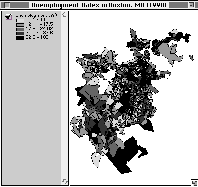 Figure 1: Thematic Map of Boston Unemployment
Source: U.S. Census, 1990
This problem exists because out-of-the-box GIS interfaces are designed to have broad applicability, but this standardization limits the ability of users to fully exploit the program. The need for better GIS interfaces is currently being addressed by individual users and third parties who develop "modules" using the GIS package's scripting language (the fact that all major GIS packages have a scripting language is an acknowledgment of this weakness in the user interface). Modules have been developed for forest management, political redistricting, bus routing, etc. This section can be thought of as the beginnings of an urban design module.
There are four parts to the construction of this module. First, one must decide what the important things to know about a city are in order to understand it (Kevin Lynch proposed that a city's edges, nodes, paths, districts and landmarks must be known). Second, we must define algorithms for the identification of these "important things". Third, the user interface must strike a balance between simplicity and flexibility. Right now, GIS user interfaces err on the flexible side, allowing a multitude of operations if the user can figure out how to perform them. A GIS for urban design should be easily employed by an urban designer, so beyond the creation of functions with specific application to the urban design field, an interface should be created which maximizes the ability of the designer to explore the study area.
Fourth and finally, an urban design module must be flexible in terms of the definition of algorithms. Urban design is different from most disciplines that use GIS in that there are few generally accepted procedures that are implemented the same way in every situation. Defining the "important things" that must be known about a place is an issue that many people have an opinion about, but no official body, such as the American Planner's Association, has set down any rules on this question. For example, we may think that an algorithm to find the shortest path from one place to another is an important tool, but a designer may think that the time or distance between two places is relatively unimportant to the design of an urban area when compared to issues such as safety, a feeling of home, etc. "Although attempts have been made to reduce design to completely explicit systems of search or synthesis, it remains an art, a peculiar mix of rationality and irrationality. Design deals with qualities, with complex connections, and also with ambiguities" (Lynch, 1981). So an urban design module must allow the user to create their own analysis tools, but not by simply providing a scripting language that is closer to programming than using an existing program.
Landscape abstraction should transcend traditional human understanding of the physical world, and most importantly extend the limit of our perception of reality.--Perron and Miller, 1991
As stated earlier, finding patterns in the landscape is crucial to being able to understand the workings of a place. This is a task to which GIS is well suited because of its ability to overlay spatially referenced data sets and contrast and compare their attributes. The way this is often done in GIS analyses is to choose a number of data sets, perform the overlay, and then classify the resulting data set's values into a thematic map. I did not want to use this method because it seems to presuppose a knowledge of which data sets to overlay and what value will be important in the end. Instead, I start with a place of interest. The user can find out everything about the place (limited only by what data sets are available). Then the user can find other similar places throughout the city. All of the intricate overlay commands are transparent to the user, so they can concentrate on the exploration process.
The rough pattern finding module uses ArcView as its GIS and is coded in Avenue, ArcView's scripting language. In order to combine these theories into a prototype pattern finding application, it was necessary to predict a certain mode of operation for the hypothetical user. This model assumes that the planner has in-depth knowledge about one place--usually an street corner or a parcel, and wants to find out the underlying characteristics about this place as well as other places that have similar characteristics. This process is modeled by having the user select a building in the area of interest. The program then allows the user to select any of the themes present in the ArcView "view" that is of interest to the analysis. In Figure 2 the user has selected population density. The next step is to decide what range of population density is important. The value at the location of the building (109.98) is given as a starting point, but the user decides that 100 is a better minimum value. The maximum value is chosen in the same manner, and then additional themes may also be added to the pattern. After all of the parameters are entered, the program finds all areas in Boston that meet all of the criteria.

Figure 2: Pattern finding prototype
In this way, information about one place can be used to help the user find other places that are likely to be similar without having to study every acre of the city in detail. This proves to be a very stimulating method of analysis, especially when places with similar characteristics look quite different "on the ground."
Nodes are points, the strategic spots in a city into which an observer can enter, and which are the intensive foci to an from which he is traveling. They may be primarily junctions, places of a break in transportation, a crossing or convergence of paths, moments of shift from one structure to another. Or the nodes may be simply concentrations, which gain their importance from being the condensation of some use or physical character, as a street-corner hangout or an enclosed square. Some of these concentration nodes are the focus and epitome of a district, over which their influence radiates and of which they stand as a symbol.--Kevin Lynch, Image of the City, pp. 47-48
So nodes are either notable intersections of paths or concentrations of activity. In fact, these two definitions are self-reinforcing, as centers of activity often develop at important intersections, and paths are often created to service major nodes.
 Figure 3:
The Boston Center for the Arts (BCA) Node
In Boston's South End, the area around the Boston Center for the Arts (BCA) is a major node (Figure 3). The BCA is a multi-purpose facility where art classes and exhibitions are held and artists lofts and studios are located. The block containing the BCA is on the north side of Tremont Street, with a small theater next door and a music school and a parking lot behind. Across from the BCA and along Tremont heading southwest are a number of small businesses including coffee shops, restaurants and antique stores. The Tremont/Berkeley Street intersection is a heavily traveled automotive path, with commuters on their way to and from the Massachusetts Turnpike and Interstate 93. Pedestrians from the surrounding residential areas use Tremont Street as a destination (previously mentioned cultural and commercial uses) and as a path to downtown Boston, located on the north side of the Mass. Pike. Many children are also seen in the area, as a number of schools are within a three block radius of this node.
It is easy to picture a typical day in this node (Figure 4), with people hurrying to work and school in the morning, adults grabbing coffee and breakfast along the way and everyone avoiding the cars speeding along the streets towards the downtown office buildings. Mid-day is quieter. Those who are fortunate enough not to have to work visit the art exhibitions and stop in for a long lunch at a local café and maybe browse the antique stores, hoping for a great find. The afternoon brings a flurry of street activity as school lets out, and before you know it dinner is being served at the restaurants. The area may remain lively well into the evening if there is an art opening or a play that night.
 Figure 4: Photograph of the BCA node
This knowledge is a result of many visits to the area over the course of a three-month investigation of the neighborhood. The task here, however, is to identify this node solely through the use of our database (local resident input will be added to the system later). Earlier, nodes were defined as intersecting paths and/or centers of activity. Every street is a path-- although paths do not have to be streets, but there are too many street intersections for this to be an unqualified definition of a node. Each may be a node in a micro reading of a site, but here we are concerned with neighborhood/city scale. Therefore, the following conditions will lead to a more accurate attribution of the term node for urban planning.
A place may be a node if it is situated along a major street. Major may be defined in an urban setting as a street of at least four car widths. This translates at the minimum into one lane of traffic in each direction, with parking on both sides. Sidewalk width is also important, as it influences people's ability to interact with each other in this public setting (Jacobs, 1961). Sidewalk data is unfortunately too often neglected in the construction of an urban database. The node is further strengthened by having a nearby intersection with another active street. Street activity may be difficult to define in a database because narrow streets like Berkeley Street can be very active. Attaching traffic count data to the street network would greatly enhance our ability to understand street dynamics with a GIS.
Nodes are also defined as concentrations of activity. This concept can be applied to a GIS by finding areas where multiple land uses come together. Ecologists have found that the areas of greatest diversity in animal and plant species occur where different land uses meet (Forman, 1987). Wetlands are so important because they are the transition area between forests, fields and water. Being rich in food sources they also attract animals from the land, air and water. The same theory can be applied to the human species. Because of the varied needs of people, the greatest level of activity will be found in areas that service the greatest number of needs. We see the BCA is coded as commercial land use (orange) with institutional uses (yellow) found to the west and east. Residential areas surround these public uses, which is crucial because public areas without nearby residential districts become ghost towns at night and on weekends.
So this node can be found with a GIS because:
* it is on a major street
* the sidewalks on the major street are wide
* it is near the intersection of two busy streets
* many land uses meet in this small area
* residential areas are nearby
* commercial and institutional uses are present
The above specifications serve to define a general idea of the kinds of conditions that the GIS must identify. The next step is to create an operational definition of node which will lead to the formulation of an algorithm that will allow the designer to tell the computer, "find nodes!" The form of this algorithm, as stressed throughout this paper, is something which is unique to each user. Using the above specifications as a guide, a number of algorithms were tested in an attempt to simulate the modus operandi of an urban planner.
Starting with the premise that the area around urban nodes must include commercial, residential and institutional uses, I use an algorithm (run in ArcInfo's GRID module--the search was implemented with the FOCALVARIETY command) that searches the 1:25,000 scale land use coverage in a 500-foot radius for different uses (Figure 5). If the aforementioned land uses are not present, then the point can not be a node. If they are present, the point is ranked in comparison to other nodes based upon how many different types of land use are present in the area (Figure 6). During the course of this research, as often happens in real life, a more detailed source of land use data became available, so I am able to run the same analysis using parcel-based land use (Figure 7).
 Figure 5: Node-finding algorithm
 Figure 6: Nodes generated using 1:25,000 scale land use data
Click to see a full-scale image
 Figure 7: Nodes generated using parcel-based land use data
Click to see a full-scale image
 Figure 8: Kenmore Square node
Figures 6 and 7 tell very different stories about where activities are concentrated in downtown Boston. A field investigation of the area proved that the algorithm worked very well using parcel-based land use (Figure 7) as a data source, and poorly using the 1:25,000 scale land use (Figure 6). This is partly due to the fact that the coarse land use data classified many multiple use areas as residential only, probably because it was derived from aerial photography, which only shows the tops of buildings. This ends up obscuring the condition of retail uses on the ground floor and housing above, which is very common in downtown Boston (Figure 8).
So although the coarse land use data set found many of the same areas as the detailed data set, it was not able to accurately rank levels of activity, and in many cases, the areas it found were not active at all. The detailed land use, however, found only the busiest areas of the city and came up with only one inaccurate node, which is probably due to an error in the way the data was entered.
Although progress was made in creating a "sketch plan" of the city, detailed data relating to the movement of people and vehicles would have been valuable because it could have helped to explain how people move from home to node and from node to node. It also could have helped answer some interesting questions that were raised regarding how similar areas in the city relate to one another.
This study has shown, however, that GIS analysis can play an important role in urban design. The pattern finding application stimulated a great deal of exploration and discussion among the planners that tested it. The node finding application proved to be a powerful tool, as it accurately located the busiest areas in the city using only a detailed land use coverage and a well thought out algorithm.
Alexander, Christopher, Ishikawa, Sara and Silverstein, Murray, A pattern language: towns, buildings and construction, Oxford, 1977.
Alexander, Christopher, Notes on the Synthesis of Form, Harvard University Press, 1964.
Banerjee, Tridib and Southworth, Michael eds, City Sense and City Design: writings and projects of Kevin Lynch, MIT Press, 1990.
Clayton, Mark J. and Weisenthal, Howard, Reality and Virtual Reality, "Enhancing the sketchbook," NJIT, 1991.
Dave, B., Schmidtt, G., Environment and Planning B: Planning & Design, "Information systems for urban analysis and design development," Pion, volume 21, 1994, pp. 83-96.
Forman, Richard T. T., Landscape Ecology, Wiley, 1986.
Decker, John, Cities, "Computers as tools for analysis of urban spaces," Butterworth-Heinemann Ltd, volume 9, issue 3, 1992, pp. 170-176.
Hillier, Bill, The social logic of space, Cambridge University Press, 1984.
Jacobs, Jane, The death and life of great American cities, Vintage, 1961.
Jones, R. M., Edmonds, E A & Branki, N E , Environment and Planning B: Planning & Design, "An analysis of media integration for spatial planning environments," Pion, volume 21, 1994, pp. 121-133.
Kovács, L. B., Galle, P., Environment and Planning B: Planning & Design, "The logic of plaza space: representing design knowledge on shape and function," Pion, volume 21, 1994, pp. 159-177.
Lynch, Kevin, The Image of the City, MIT Press, 1960.
Lynch, Kevin, Good City Form, MIT Press, 1981.
March, L. and Steadman, P., The Geometry of Environment: an introduction to spatial organization and design, MIT Press, 1974.
Nijkamp, P. & Scholten, H. J., International Journal of GIS, "Spatial information systems: design, modelling and use in planning," Taylor and Francis, volume 7, issue 1, 1993, pp. 85-96.
Perron, Richard and Miller, Deron, Reality and Virtual Reality, "Landscape of the mind," NJIT, 1991.
Rowe, Peter G., Design Thinking, MIT Press, 1987.
Ruggles, Clive L. N., International Journal of GIS, "Structuring image data within a multi-media information system," Taylor and Francis, volume 6, issue 3, 1992, pp. 205-222.
Samet, Hanan., The design and analysis of spatial data structures, Addison-Wesley, 1990.
Shiffer, M. J., Environment and Planning B: Planning & Design, "Environmental review with hypermedia systems," Pion, volume 22, 1995, pp. 359-372.
Sun, D., Environment and Planning B: Planning & Design, "Memory, design and the role of computers," Pion, volume 20, 1993, pp. 125-143.