For several years, the Land Information and Computer Graphics Facility (UW-LICGF) at the University of Wisconsin-Madison has been monitoring the status of land records modernization in Wisconsin local governments. Much of the work in Wisconsin has been promoted by the Wisconsin Land Information Board, a state Board offering financial, legal, and technical assistance to local governments engaged in modernization. Our monitoring efforts have been realized through the use of the Wisconsin Land Information Board Annual Report Surveys, a requirement for participation in the Wisconsin Land Information Program.
The Ohio State University has been working in cooperation with the Ohio Geographically Referenced information Program to utilize similar surveys in Ohio. While those efforts are proving to be quite successful, the results were not ready for publication in this paper.
While this paper focuses on the results of the Wisconsin surveys, a brief mention of the theoretical basis for this research would be helpful. The existing literature has provided some basis for the underlying concepts concerning the process of modernization (Onsrud and Pinto 1993, Masser and Campbell 1994, Masser and Onsrud 1993). In addition we are continuing to work on monitoring the modernization status (Ventura et al. 1993, Kuhlman and Niemann 1995) and developing a theoretical model that describes the stages, associated factors and outcomes of the land records modernization process (Kuhlman 1993, Tulloch et al. 1995a, Tulloch et al. 1995b) These papers should act as a guide for readers seeking a foundation for results reported in this paper.
The Wisconsin Land Information Board (WLIB) was created by the Wisconsin legislature in 1989 as a tool to assist local governments in land records modernization. One of the primary sources of this assistance was a six dollar increase state-wide in land recordation fees. These six dollars are spilt with four dollars remaining in the county for modernization, and two dollars going to the WLIB to be redistributed to local governments in the form of competitive grants-in-aid.
The Wisconsin Land Information Program (WLIP) is governed by the WLIB. Since the Program's inception in 1991, it has generated and distributed over 30 million dollars in fees and grants-in-aid. These grants allow the Program to help counties interested in addressing an issue or project requiring a especially large lump sum or less populated areas which generated fewer fees.
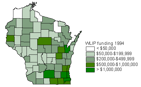
Figure 1 -- Total Funding (Fees and Grants) Distributed by the Wisconsin Land Information Board From 1991-1995 (1994 survey)
In cooperation with the Wisconsin Land Information Board (WLIB), a survey was designed to satisfy both practical and research questions about the status of modernization in Wisconsin local governments in 1994. Utilized annually as a reporting mechanism for counties participating in the WLIP, the survey allows the WLIB to monitor the expenditure of grants-in-aid and retained fees.
Whenever possible, guidelines for survey preparation and distribution as described by Dillman (1978) and Babbie (1990) have been followed. However, because of the unique use of the annual reporting mechanism as a survey, response rates were not the driving force behind decisions as much as completeness, clarity, and accuracy of data.
The surveys were sent to the Land Information Officer (LIO) for each of Wisconsin's 72 counties. Although more surveys have been processed subsequently, the data reported in this paper reflects a response rate of 96%.
Measuring expenditure patterns is a key tool for evaluating modernization activities. In Wisconsin, the WLIB has established eight Foundational Elements as areas on which local governments are strongly encouraged to focus their efforts. As shown in Figure 2, only two of the Foundational Elements stand out as having received a significant portion of the total funding. These two Elements -- parcel mapping and geo-reference framework -- do require extensive work early in the development of a land information program. However, if a program is healthy, we would expect to see those expenditures shifting from these basic Elements to natural resource (e.g. wetlands) and application (e.g. zoning) oriented Elements.
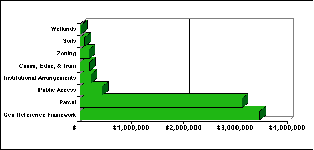
Figure 2 -- Total Expenditures by Foundational Elements (1994 survey)
Another way to analyze the same expenditure data is to measure the number of counties reporting any level of expenditure for each Foundational Element. The emerging pattern (Figure 3) shows that dramatic differences in dollar amounts do not directly reflect the numbers of counties addressing each element. The most dramatic element is Communications, Education, and Training, which received a relatively small investment but was the item addressed by more counties than any other Element.
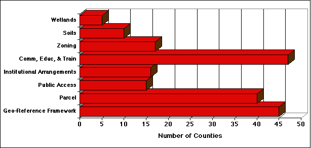
Figure 3 -- The Number of Counties Reporting Expenditures on Each Foundational Element (1994 survey)
When considering the expenditure data, we felt it was important to determine the source of funding for modernization (Figure 4). The counties in Wisconsin have reported investing roughly as much money from outside sources (including their own county and municipal levies) as from the WLIP grants and fees. This demonstrates the level of importance governments place on their land information program and the commitment they are willing to provide.
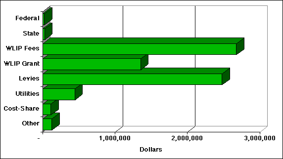
Figure 4 -- Sources of Expenditures on Foundational Elements (1994 survey)
Another indicator of the level of modernization is the number of foundational elements being addressed by a county. As an organization modernizes, the number of foundational elements should increase even though the expenditures on some elements may be reduced to a minimum cost of maintenance. The data concerning the number of elements addressed (Figure 5) is reassuring because it shows that the majority of counties are addressing multiple elements. The results also reflect a steady increase from one year to the next.
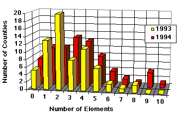
Figure 5 -- Number of foundational elements for which counties reported expenditures (1994 survey)
An overall measure of the continuing modernization is the type of GIS/LIS software being used (Figure 6). While we want to avoid commenting on individual applications, some valuable insights are available through these data. A very reassuring sign is that in 1992 the most popular GIS/LIS software was "none," in 1993 "none" had slid to second, and in 1994 it fell to third. Indicating the general growth is the large increase in number from 1992 to 1994 of most software products. The sudden jump of ArcView (a new product in 1993) past ArcInfo shows the importance of making the data and the technologies accessible to managers and decision-makers who lack expertise with more complex software packages.
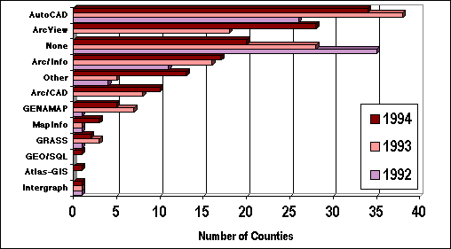
Figure 6 -- Number of Wisconsin counties using various GIS software packages (1992, 1993, 1994 surveys)
To measure counties' ability to address changing issues of technology we asked about the means of production for work, products, and services (Figure 7). As a probable sign that counties have progressed towards independence, respondents most recently indicated that 54% of their expenditures were allocated to in-house activities as opposed to 46% spent on outside vendors. In 1993, the division for the same categories was 60% and 40%.
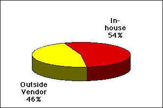
Figure 7 -- Division of expenditures between in-house staff and outside vendors (1994 survey)
In an effort to study the process of the diffusion of land information technologies, the UW-LICGF employed a separate survey of the Wisconsin Land Information Association's 800 members. This survey resulted in a 62% response rate and provided a variety of data, much of which will be reported at some time in the near future. However, the results for one specific question are quite relevant to this paper.
We asked respondents to describe the progress of their local government as having reached one or more of the following stages: no modernization, system initiation, database development, recordkeeping, analysis, and democratization (Figure 8). The responses to the question showed a strong focus of organizations around the stage of database development. The overall trend in responses show that Wisconsin local governments are progressing towards more advanced and productive systems.
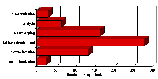
Figure 8 -- The stages of modernization that land information professionals felt their local government was experiencing (1995 Diffusion Survey)
In order to improve the program, LIOs were asked to evaluate the support provided by the WLIP. While much of the evaluation portion of the survey addresses specific issues, it also provides an important measure of the value that counties place on the program.
As a general measure of effectiveness, respondents were asked about the role that the WLIP has played in initiating their counties' efforts (Figure 8). Every county indicated that the program had played some role in accelerating their counties' modernization efforts. Only five counties said that the WLIP had "very little" involvement in this acceleration of the process.
A parallel question inquired about the Program's role in initiating the counties' programs. Although two counties responded that WLIP's role had been "not at all" and another five reported that it had been "very little," the vast majority of counties still indicated that WLIP had played a significant role in initiating their programs.
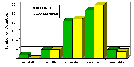
Figure 9 -- Response to the question, "What role has the WLIP played in initiating/accelerating land records modernization in your county?" (1994 Survey)
These overall indicators of the success of WLIP illustrate the importance that county Land Information Officers (LIOs) place upon the Program. This evidence also shows that a well-orchestrated state-wide program can play an important role in both initiating and accelerating land records modernization.
As an on-going project, this research has relied on many people. However, it is possible to identify a few who have been helpful for expediting this research. Doug King, Georgia Hopf, and Susan Simon of the Wisconsin Land Information Board have helped with the practical nature of dealing with 72 different counties. Funding has come from the National Center for Geographic Information and Analysis and the National Center for Resource Innovations.
Babbie, Earl, Survey Research Methods, Belmont, California: Wadworth Publishing, 1990.
Dillman, Don, Mail and Telephone Surveys: The Total Design Method, New York: John Wiley, 1978.
Kuhlman, Kristine, "Building a Framework to Characterize Land Records Modernization," In Urban and Regional Information Systems Association Proceedings, 146-151, 1993.
Kuhlman, Kristine, and Bernard J. Niemann, Jr., "Modernizing Land Records: Tracking GIS/LIS Technology in Wisconsin and Beyond," URISA Journal, 7 (1993) 1, 60-63.
Masser, Ian, and Harlan J. Onsrud (Eds.), Diffusion and Use of Geographic Information Systems, Kluwer: Dodrecht, 1993.
Masser, Ian and Heather Campbell, "Monitoring the Take-Up of GIS in British Local Government," In Urban and Regional Information Systems Association Proceedings, 745-754, 1994.
Onsrud, H. J., and J. K. Pinto, "Evaluating Correlates of GIS Adoption Success and the Decision Process of GIS Acquisition," URISA Journal 5 (1993): 1, 18-39.
Tulloch, David, Bernard J. Niemann, Jr., Stephen J. Ventura, and Earl Epstein, "Land Records Modernization in Local Governments," 1995 Esri Users Conference Proceedings, Palm Springs, CA, May 1995(a).
Tulloch, David, Bernard J. Niemann, Jr., Stephen J. Ventura, Abdul Hadi Harmans Shah, Earl F. Epstein, and William Holland, "Land Records Modernization in Local Governments," 1995 Proceedings of the Urban and Regional Information Systems Association, San Antonio, TX, July 1995 (b), 487-496.
Ventura, S. J., P. Kishor, B. J. Niemann, K. Kuhlman, E. Epstein, and W. Holland, "Laws That Drive Change: GIS/LIS Development by Local Governments," GIS/LIS '93 Proceedings, vol. 2, 681-690, 1993.