Figure 1
GIS in Support of Anadromous Fisheries Restoration Planning
After an initial orientation to the capabilities of GIS in fisheries restoration planning, there was interest among Technical Work Group members to have past restoration projects funded by the Task Force georeferenced and displayed on a map. To help prioritize fishery restoration efforts it is useful to assess what types of projects have been funded in the past and were they are located. Once we determine were the different types of restoration efforts have occurred, we will be able to assess the potential effectiveness of future projects.In cooperation with staff from the U.S. Fish and Wildlife Service (USFWS), Klamath River Fish & Wildlife Office (KRFWO) in Yreka, California, project information was used to assign a location, or georeference point, to specific restoration projects. Along with the actual point location, an accompanying data base was integrated into the restoration data layer. Restoration projects were placed into six categories: (1) Education, (2) Habitat Protection, (3) Habitat Restoration, (4) Fish Population Protection, (5) Fish Population Restoration, and (6) Planning and Coordination. Other projects undertaken by other agencies were then added to the database. The California Department of Fish & Game (CDFG), Inland Fisheries Division, has provided a fisheries restoration projects data layer of CDFG-funded projects within the Klamath Basin.
In addition to georeferencing past restoration efforts, a data layer of restoration projects submitted for Task Force funding during Fiscal Year 1996 was developed. This layer depicted the type of proposed project and its approximate location within the Klamath River Watershed and respective sub-basins. These maps allow resource specialists and decision makers to graphically compare locations and types of past restoration projects with proposed projects to help prioritize restoration efforts and funding. Future endeavors will continue to build upon restoration data layers, including the incorporation of US Forest Service projects, USFWS Partners for Wildlife projects and Klamath Basin Ecosystem Restoration Office projects. Planned additions to the restoration data layer include digital images of proposed restoration project locations and post-restoration results.
Sub-Basin Restoration Prioritization
The Restoration Program is in the process of performing a mid-program review which will re-evaluate the effectiveness of the program. As part of this mid-program review, the Restoration Program's GIS data layers and data bases are being used to assess what types of restoration projects have been completed. Through data base queries, restoration dollars are accounted for within each of the restoration programs categories (Education, Fish Population Protection, Fish Population Restoration, Habitat Protection, Habitat Restoration, and Planning and Coordination).As part of reassessing where to allocate restoration dollars, these data bases has illustrated the need for expanded and continuing planning and coordination of restoration efforts. For example, in the Lower Klamath River sub-basin approximately 1.7 million dollars have been spent on fish population protection/restoration, and habitat protection/restoration between 1987-1995. During this same time frame there has not been any funds allocated towards planning and coordination. This demonstrates the need to develop specific sub-basin action plans that address the specific resource restoration issues of each sub-basin.
Anadromous Fish Species Occurrence and Distribution
In cooperation with the Klamath National Forest Fisheries and GIS departments, fish species distribution data layers have been acquired and will be used to help prioritize fish population protection and restoration efforts. These data layers represent the historic range of fish species as well as current distribution. These data layers will become pivotal with the potential listing of certain fish stocks under the both federal and state threatened and endangered species acts.These data layers allows fisheries resource specialists to identify current distribution of the anadromous fish species and compare with historic ranges. This information can be used to assess habitat loss and distribution patterns. Identification of anadromous fish species distribution will assist resource managers in the protection of key watersheds that currently support viable fish populations. Adoption of the philosophy of Protecting the best, and Restoring the Rest will assist in the prioritization of restoration efforts.
Future GIS Applications in Anadromous Fisheries Restoration Planning
The utility of GIS-related products and the general support provided by the GIS analyst generated interest by the Task Force for continuing support of GIS efforts. Fiscal Year 1995 discretionary planning funds have been allocated to provide the Task Force and Technical Work Group (TWG) with a full-time GIS Analyst. A cooperative agreement between the USFWS and the Humboldt State University Foundation served as the funding mechanism to continue and enhance the GIS capabilities of the Task Force and TWG.The objectives of the cooperative agreement are to provide map layers, fishery restoration data, spreadsheets and other products that assist the Task Force and TWG in reviewing past restoration efforts and prioritizing ongoing fishery restoration within the Klamath River Basin. The GIS Analyst continues to work with the Task Force, TWG and the USFWS Klamath River Fish & Wildlife Office in analyzing and disseminating information related to Klamath River Basin fish habitat and fish restoration projects.
In the Restoration Program's fiscal year 1996, Request for Proposals (RFP), the RFP asked project proposers to include a map of the proposed project location. This request resulted in a variety of different types of project maps with different sources and scales being submitted with the completed proposal. This made the referencing of the proposed projects difficult, and in many instances generalized point locations were assigned to projects. Project maps ranged enlarged photocopies of USGS quad maps to generalized small scale maps.
It became apparent that in order to consisting represent fishery restoration project locations, it would be necessary to develop a series of standardized sub-basin maps that will be included with future Restoration Program Request for Proposals. As part of developing these series of base maps, the EPA River Reach Files (RF3) will serve as a 1:100,000 base hydrology layer to reference project locations. These base maps include hydrologic sub-basin boundaries, annotated sub-basin hydrologic stream networks and a 7.5 minute USGS 1:24,000 quad index. The base maps also provide instructions for project proposers when assigning proposed project locations.
For projects that are linear in nature, such as cattle exclusionary fencing and riparian vegetation enhancement projects, proposed project reaches are highlighted on the base map. In addition to referencing proposed project locations on the 1:100,000 scale base maps, project proposers are asked to provide a more detailed site map based on standard 1:24,000 USGS quad maps.
EPA River Reach Files, Version 3 (RF3-Alpha)
The RF3 program is being developed by EPA's Office of Water to provide a nationally consistent database to promote compatibility for national, regional, and state reporting requirements such as those found in 305(b) and other sections of the Clean Water Act (McKay et al., 1994). In support of EPA's objective of restoring and maintaining the quality of the nation's waters, numerous environmental studies have been undertaken that rely upon flow estimates. Typical studies include waste load allocations, water quality trends, impact of discharges on water intake sites, and designated use studies. The EPA is currently developing flow estimation procedures which will utilize RF3 data sets. A work group was formed in 1992 to study the issues associated with the development of flow estimates for RF3 and to develop a preliminary plan and resource requirements for making such estimates (Bondelid et al., 1992).The official release of RF3 by the EPA is expected in the fall of 1996. In the meantime, public agencies have been given permission to utilize the data while procedures are being developed to manage RF3 updates on a national scale.
The basic building block of the EPA River Reach File is the reach, a distinctly identified lineal stream feature. A reach may be either: (1) the linear hydrographic feature between two stream confluence's, or (2) a unique hydrographic feature as denoted by the source data (e.g., USGS Digital Line Graphs). The distinction between these two definitions is that the first reach type is normally connected hydrologically with other reaches, while the second reach type is an isolated feature. Reaches are given a unique reach address (RF3RCHID). The RF3RCHID, is a string of numbers composed of three concatenated fields, CU-SEG-MI where
	CU	= 	the USGS Cataloging Unit
	SEG	= 	the stream SEGment, and
	MI	= 	the Marker Index (Veisze, 1994).
Codes are also assigned to indicate subfeatures such as intermittent streams, canals/ditches, rapids, water bodies and wide rivers. Most hydrologically connected reaches are called transport reaches while others are referred to as start reaches (headwaters) or simply as non-transport reaches.
The initial step was to acquire river reach data sets from cooperating agencies. The California Department of Fish & Game, Inland Fisheries Division and the Oregon State Service Center for Geographic Information Systems (SSCGIS) provided data sets for their respective states.
California Reach Files. The RF3-Alpha compilation is being done on a cataloging unit (watershed) basis. The present California RF3 was derived from 1:100,000 USGS Digital Line Graphs (DLGs) of streams (Figure 2), as reprocessed and archived by California's Teale Data Center GIS Lab in ArcInfo format. After importing the files into the HSU GIS Technical Work Group database, the coverages were projected into a Universal Transverse Mercator (UTM) map projection based on NAD27 datum.
Oregon Reach Files. The hydrologic data sets provided by the Oregon SSCGIS and USGS Water Resources Division are not part of the EPA's RF3 program. The data sets for Oregon, the Pacific Northwest River (PNW) Reach Files, do not share the same structure with the California RF3 data sets. The PNW files are a georeferenced river reach data base at 1:100,000 scale which are encoded with US EPA Enhanced Reach File (RF2) reach codes. The line work came from the same USGS DLGs but they were compiled in a completely different manner. Combined with EPA STORET reach identifiers the PNW River Reach files are an integral hydrologic component in a regional Northwest Environmental Data Base, an ongoing effort by federal and state agencies to compile reach-specific information on rivers in Oregon, Idaho, Washington and western Montana (Fisher, 1993).
An on-going priority of the broader HSU-GIS Technical Work Group program is to create a seamless GIS river reach data layer for the entire Klamath River Basin and Klamath Economic Zones. The disparate structures of the two reach file data sets will require the development of common attributes, codes and structures in order to be incorporated into a seamless reach file data layer.
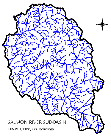
Figure 2
Hydrologic Unit Boundary Data Layers
Developing a hydrologic and hydrographic data base to support anadromous fisheries restoration planning requires the delineation of watershed boundaries. A variety of planning areas and scales required evaluation of different hydrologic unit or watershed boundary schema.Hydrologic Unit Code (HUC) coverages provided by the California Department of Fish & Game , Inland Fisheries Division provided general watershed boundary delineation at the 1:250,000 scale. This HUC layer has been adopted by CDFG to provide statewide watershed unit boundaries. This coverage has been modified by the HSU-GIS Group to correlate with the 1:100,000 EPA RF3 data.
The California Department of Forestry & Fire Protection (CDF) has developed a much more detailed watershed data layer. CALWATER 1.0-California Planning Watersheds, has been developed and maintained by the CDF's Strategic Planning Program to aid state forestry programs and help in timber harvest planning. The associated database includes such attributes as: (1) State Water Quality Control Board region number; (2) State Water Quality Control Board hydrologic unit; (3) State Water Quality Control Board hydrologic area; (4) State Water Quality Control Board subarea and (5) watershed name. The planning watersheds have also been grouped into one or more planning watersheds up to approximately 50,000 acres and further subdivided into planning watershed units between 3,000 and 10,000 acres.
The Oregon SCCGIS and the Oregon Department of Fish & Wildlife provided watershed data layers at the 1:500,000 and 1:24,000 scales. These data sets were used to help identify and delineate watershed boundaries for the Oregon portion of the Klamath River Basin. For most practical purposes we employed the 1:24,000 scale hydrologic unit code boundary layer.
A hybrid watershed boundary coverage was developed using CALWATER and Oregon 1:24,000 data layers. This hybrid watershed layer merged the two different data layers to provide the best possible basin-wide watershed layer with the existing GIS data sets (Figure 3). CALWATER was also used as a background coverage to provide updates to existing USGS cataloging unit sub-basins. Watershed sub-basin areas were calculated on a cataloging unit basis. Table 1 presents sub-basin areas in acres and hectares and allows resource managers to compare watershed planning areas within the basin.
TABLE 1
USGS Cataloging         Name            HA         Acres
     Unit

   18010201      Williamson          378,191     934,509
   18010202      Sprague             416,764   1,029,823
   18010203      Upper Klamath Lake  188,146     464,908
   18010204      Lost                779,572   1,926,322
   18010205      Butte               156,227     386,036
   18010206      Upper Klamath       366,929     906,681
   18010207      Shasta              205,779     508,479
   18010208      Scott               210,688     520,610
   18010209      Lower Klamath       398,506     984,708
   18010210      Salmon              194,325     480,177
   18010211      Trinity             527,419   1,303,252
   18010212      South Fork Trinity  240,750     594,893

                 Total             4,063,296  10,040,398
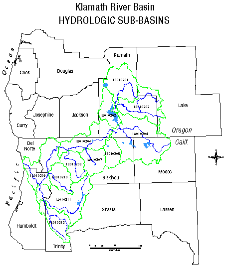
Figure 3
Land Administration and Ownership Data Layers
A 1:100,000 land administration and ownership data layer was created to delineate land administration boundaries of federal and state agencies, Native American tribes, local agencies, or private owners. Detailed sub-basin maps have been compiled from US EPA River Reach Files (RF3), hydrologic unit code boundaries, and land administration layers. These maps are be used to identify perennial, and intermittent streams, canals/ditches and land ownership patterns within sub-basins.
GIS Coordination and Cooperation
Continued coordination and cooperation in the acquisition and dissemination of geographic information continues to enhance the decision making process and the evolution of GIS in fisheries restoration planning. GIS is empowering local grass roots restoration efforts through Coordinated Resource Management Planning (CRMP) efforts in several sub-basins of the Klamath Basin. GIS orientation workshops and limited training are also being offered to agency personnel and CRMP groups.Data transfers are facilitated through a series of cooperative agreements and memorandums of understanding between cooperating entities. Data is transferred on a variety of media, including electronically via file transfer protocol (FTP) and the World Wide Web (WWW).
Through the course of these ongoing cooperative mapping efforts, coordination and data transfers has been facilitated by GIS coordinators at CDFG Inland Fisheries Division, Klamath and Six Rivers National Forests, US EPA Region IX River Reach/STORET program, California Department of Forestry & Fire Protection Strategic Planning Program, and Oregon State Service Center for Geographic Information Systems and the U.S. Fish and Wildlife Service. Contact was also made with Horizon Systems Corporation, private contractors working with EPA on the national RF3 data base development and implementation.
In addition to these state and federal contacts, the foundation for continued data coordination with non-governmental organizations and programs, such as the Klamath Resource Information System (KRIS) and CRMP sub-basin efforts has expanded. Local knowledge from CRMP coordinators and Resource Conservation District personnel are being utilized to review existing data layers for completeness and accuracy.
User needs assessments have occurred on several occasions and have provided the opportunity to identify data needs, gaps, hardware and software requirements and expanded coordination. The need for detailed site specific information continues to drive the data collection and cooperation towards finer resolution data sets. Continued GIS data coordination is expanding with new cooperators entering into the collaborative mapping efforts in the Klamath River Basin. Incorporation of additional data sets and map layers is a ongoing process. Current efforts are at the 1:100,000 scale with future efforts expanding to incorporate basin wide 1:24,000 scale information.
Klamath Basin GIS Technical Work Group at Humboldt State University
The Klamath Basin Ecosystem Restoration Office/Humboldt State University GIS Technical Work Group (ERO/HSU-GIS Group) at Humboldt State University was established to support the Klamath Basin Ecosystem Restoration Office's mission of holistic resource management for the Klamath hydrobasin. The GIS Facility will produce and make available to all cooperators, regional, "seamless" geographic information. The primary task of the facility will be to develop a hierarchical earth registration network, register existing GIS data layers into that network, produce missing GIS data layers, and integrate both existing data and new data into seamless GIS products. The data development work is phased at three scales: 1:100,000, 1:24,000 and 1:12,000.
Literature Cited
Bondelid, T., W. Grayman, S. Hanson, B. Horn, and P. Taylor. 1992. DRAFT- EPA River Reach File, version 3 Flow Estimation Procedures-A Summary of the Technical Work Group Findings and Proposed Technical Approach. EPA Contract No. 68-C9-0013. White Paper. 25 pp.Fisher, B.J. 1993. Methodology Used To Produce An Encoded 1:100,000 Scale River Reach Data Layer For The Pacific Northwest. Pacific Northwest River Reach File Documentation. Compiled by: U.S. Geological Survey, Water Resources Division, Portland, Oregon. 26 pp.
McKay, L.D., S.A. Hanson, and R.C. Horn. 1994. EPA Reach File Version 3.0 Alpha Release (RF3-Alpha) Technical Reference, First Edition. U.S. Environmental Protection Agency. Washington, DC. 23 pp.
Veisze, P. 1994. US EPA River Reach File--Quality Assurance/Quality Control. California Department of Fish & Game, Inland Fisheries Division--GIS. Sacramento, California. 18 pp.
Robert E. Beachler
GIS Analyst, Klamath River Basin Fisheries Task Force
Humboldt State University
Department of Natural Resources Planning & Interpretation
Arcata, CA 95521-8299
HSU GIS & Remote Sensing Lab: (707) 826-5417
Fax:(707) 826-4145
email:reb1@axe.humboldt.edu