INTERACTIVE APPLICATION OF GIS DURING THE VISION WILDFIRE
AT POINT REYES NATIONAL SEASHORE
ABSTRACT
A wildfire spread rapidly through the Point Reyes National Seashore in the fall of 1995, burning over 12,000 acres. At the height of the fire suppression campaign, 2,164 personnel, including 74 handcrews, 27 bulldozers, 7 air tankers, 7 helicopters and 196 fire engines, were involved. During and immediately following the fire, Geographic Information Systems (GIS) and Global Positioning Systems (GPS) were utilized to monitor the daily/hourly spread of the fire, measure fire suppression actions, assess damage to natural resources, and evaluate damage to adjacent homes in the wildland/urban interface. Examples of GIS/GPS data layers created included fire intensity, bulldozer lines, and fire perimeter over time. Within two weeks , with the aid of GIS, a team of specialists were able to make a comprehensive assessment of the fire impacts and recommend specific actions to the park service for short and long term restoration and rehabilitation.
INTRODUCTION
Many land management agencies such as the National Park Service (NPS), have some type of Geographical Information System (GIS) and Global Positioning System (GPS). In the fall of 1995, a wildfire occurred on the at Point Reyes National Seashore, California, and during this emergency, GIS/GPS was utilized to monitor the daily spread of the fire, measure fire suppression actions, and to assess damage to structures and to natural and cultural resources. Additionally, as part of the NPS fire recovery effort, several studies were initiated to evaluate fire and fire suppression effects on the ecological integrity of communities within and adjacent to the burn area. GIS/GPS will help to monitor treatments and effected resources to determine the efficacy of measures taken to mitigate suppression and rehabilitation actions. GIS was a significant tool for integrating the data layers in a form that enabled the park to measure, monitor, and map several data themes simultaneously, providing a more comprehensive understanding of the effects of the fire. GIS, for example, will and has aided in comparing vegetation pre- and post-fire, georeferencing noxious weeds for removal, and georeferencing permanent vegetation plots and photo points. With a more complete base of information, the park can conceive of and initiate more ecologically sound mitigation projects.
Objectives of this paper are to describe the application of GIS during a wildfire in a wildland/urban interface; to demonstrate the application of GIS to assess fire, fire effects and rehabilitation methods; and to recommend how land managers might better prepare for an emergency.
THE SETTING
Point Reyes National Seashore is located in Marin County, California, approximately 40 miles northwest of San Francisco. It was established by Congress on September 13, 1962 "to save and preserve, for the purpose of public recreation, benefit, and inspiration, a portion of the diminishing seashore of the United States that remains undeveloped" (PL 87-657). The Wilderness Act of 1976 (P.L. 95-544) established 25,370 acres of wilderness and 8,003 acres of potential wilderness in the Point Reyes National Seashore, thereby adding special protection. Today, nearly half of the Seashore is included in the National Wilderness Preservation System. Encompassing 71,046 acres of coastal dunes, coastal prairies, marine terraces, coastal scrub and forests, this geologically unique peninsula has appropriately been called an "Island in Time".
Point Reyes National Seashore shares boundaries with many entities. Marine boundaries are shared with the Gulf of the Farallones National Marine Sanctuary; terrestrial boundaries are shared with Golden Gate National Recreation Area (another National Park), Tomales Bay State Park, The Nature Conservancy, and many private land owners. In 1988, UNESCO's Man in the Biosphere program designated the Central California Coast Biosphere Reserve (CCCBR) under the Internal Biosphere Program; CCCBR includes the entire Seashore, the Golden Gate National Recreation Area and other public lands in the region. Much of the eastern border of the park is shared with private landowners, many of which have large homes on multi-acre parcels. Within the park boundaries, there are several dairy and cattle ranches which have continued operation after park acquisition.
The Mediterranean climate produces heavy summer fog and moderate winter rains (average of 30 in/year). Fall tends to be hod and dry and is the period of highest fire danger when vegetation is desiccated. The year-round ambient temperatures are moderate, around 55oC; the difference in the monthly temperatures is only around 6.5oC.
THE VISION FIRE
The wildfire at Point Reyes was the most devastating wildfire in sixty years with more than 12,000 acres of state, federal and private lands burned. The wildfire was aptly named the Vision Fire after the site of ignition (Mt. Vision); however, the lessons learned from this fire also provided tremendous insights into fire management. The fire began in an illegal campground on State Park lands, and propelled by hot, dry 50 mph winds, spread rapidly through several decadent vegetation communities from the Bishop pine/Douglas fir along the Inverness Ridge to sand dunes along the Pacific Ocean. The rate of spread of the fire reached 3,100 acres per hour.
By the third day, the fire had consumed 12,040 acres from mountain ridges to the sea, including 45 privately owned homes in the wildland/urban interface. Although news agencies reported that 20% of the fire was contained on the second day, a discerning eye could easily distinguish from a map of the fire that the 25% containment represented the Pacific Ocean. The fire continued to flare up over the next 10 days, re-threatening homes along the park boundary. Not until October 16, 12 days after ignition, was the fire declared controlled. Over 95% of the fire burned within the Point Reyes National Seashore. Within the Seashore the Vision Fire burned a total of 11,410 acres, representing 25% of the park's designated wilderness.
At the height of the fire suppression campaign, 2,164 personnel including 74 hand crews, 27 bulldozers, 7 air tankers, 7 helicopters and 196 fire engines, were involved. Park Headquarters were converted into a self-contained city overnight with personnel from several agencies (NPS, California Department of Forestry, U.S. Forest Service, California Department of Corrections, California State Parks, U.S. Weather Service, Bureau of Indian Affairs, and fire departments extending from northern and central California) and organizations (Salvation Army, American Red Cross, etc.) forming an encampment on park lands.
Shortly after the fire began, the superintendent of Point Reyes National Seashore called in a team of experts from the Department of Interior, the Burn Area Emergency Rehabilitation (BAER) team. This team is composed of multi-agency, multi-disciplined resource specialists that are assembled to assess fire damage, fire suppression effects and prepare mitigation measures. The BAER team was made up of resource specialists with expertise in plants, animals, soils, water resources, cultural resources, structures, roads and trails from agencies including the U.S. Forest Service, National Park Service, U.S. Fish and Wildlife Service, U.S. Bureau of Land Management, and Bureau of Indian Affairs. Although not specifically designated, a major component of the team was GIS related.
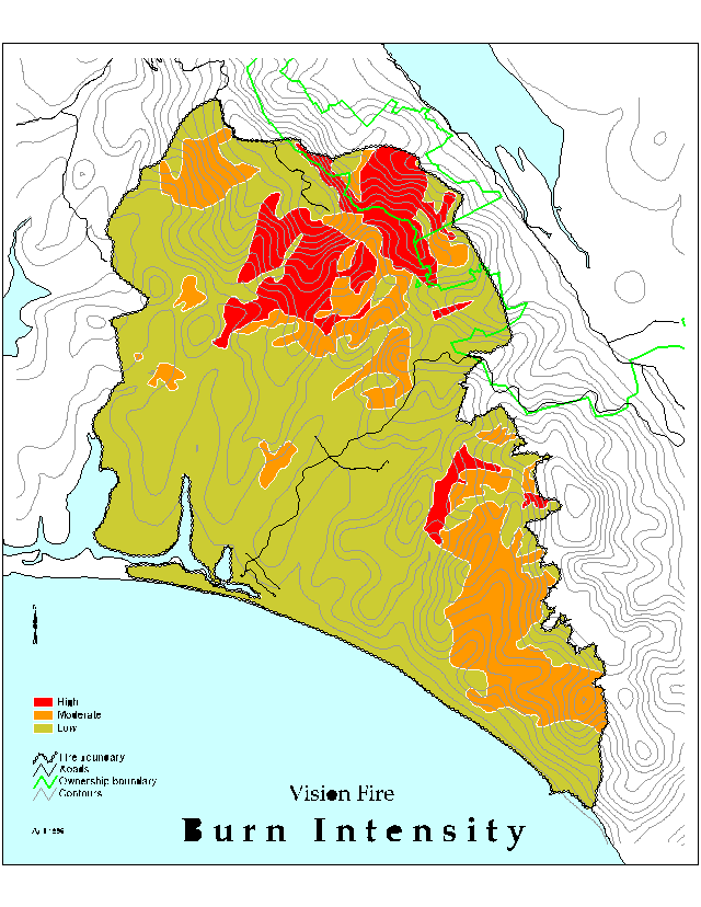
The primary task of the BAER team was to produce a report documenting the fire and fire suppression effects on the park and to make recommendations for mitigation and management; they were charged to complete the task within two weeks of fire containment. The report noted that there were extraordinary changes in the physical, chemical and biological status of park natural resources. Vegetation resources were impacted by varying degrees as burn intensities varied across the landscape, and these burn intensities in turn have the potential to influence the recovery of the ecosystems. Many areas within the fire perimeter were burned at high and severe burn intensities. Approximately 11% of the fire area was impacted by high intensity fire, 19% by moderately intense fire and 70% burned with low intensities. The plant communities within the fire area include marshland, coastal prairie, coastal grasslands, riparian, coastal dune, northern coastal scrub, bishop pine forest, and Douglas fir forest. Each of these communities has associated species that are unique to California and to the world. Within the burn perimeter, many species of plants (23), mammals (8), birds (24), insects (8), amphibians (4), reptiles (2) and fish (4) are sensitive or endemic to the park. Several species have special recognition under the U.S. Endangered Species Act and the California Endangered Species Act.
A number of plant communities and associations received burning at very high to severe intensities including Bishop pine forests, coastal scrub, northern coastal prairie and some Douglas fir forests. Many of these plant communities occur on steep slopes exceeding 60 percent. Soil associations within the burn are highly prone to erosion and are hydrophobic following exposure to moderate to intense fire. Erosion potential is very high in some region within the burn area due to this combination of factors and to locally high rainfall (14 in./mo.).
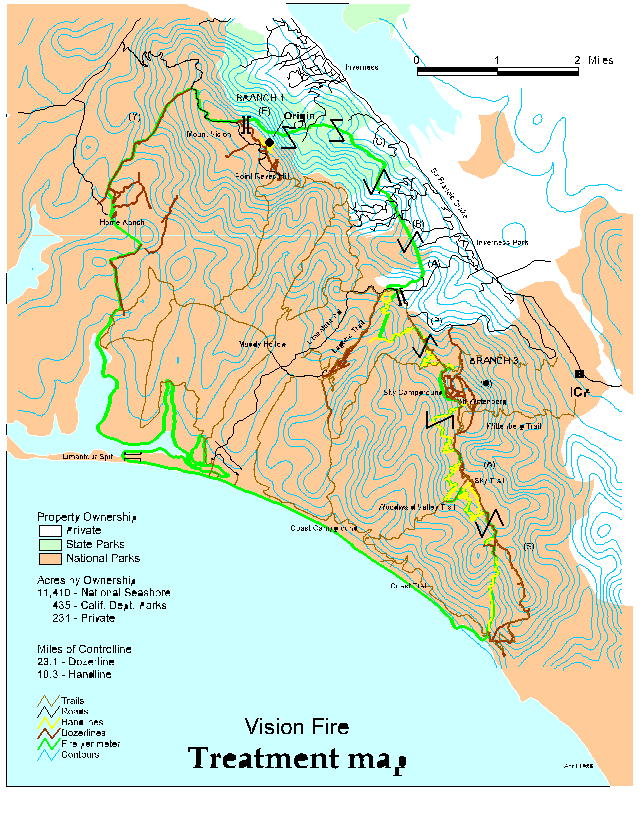
Fire suppression actions associated with containing and controlling the Vision Fire relied heavily upon direct and indirect mechanized bulldozer fireline construction. Bulldozer line construction totaling 23 miles of line occurred primarily within the wilderness; much of the dozer line construction occurred in the upper reaches of watersheds with impacts to existing trails with direct line construction on extremely steep and unstable slopes. Mechanized dozer lines in some areas traversed locations of known noxious weeds and increased the potential for spread of these species. Downslope of the line construction activities are numerous watersheds, riparian areas, wetlands and estuaries.
Both the fire and the fire suppression efforts exposed many cultural resources; Native American midden sites were uncovered, as well as historical ranch dump sites dating back to the turn of the century. In addition to the 45 structures destroyed by the fire, tens of telephone poles were damaged and an estimated 2,000 hazardous trees posed a risk to park visitors along roads and trails.
GIS SUPPORT
During and immediately following the Vision fire, GIS was utilized to map and monitor the hourly/daily spread of the fire, measure fire suppression actions, assess damage to natural resources, and evaluate damage to adjacent homes in the wildland/urban interface. These tasks were possible, though, only through the efforts of many personnel and the generous support of state and federal agencies, private organizations and vendors. Point Reyes National Seashore, like many parks, had a fledgling GIS program with some equipment in place and was in the process of upgrading and moving to new quarters when the fire occurred. Fortunately, within only a 12 hours of fire ignition, the California Office of Emergency Services dispatched a strike team of GIS specialists to aid in fire analysis. This team was a self-contained unit including four specialists and hardware and software capable of assessing the spread of the fire. Upon this foundation, a fully operational GIS lab was in place within two days of fire ignition. The GIS lab extended through three offices and connecting hallways. Cables snaked through offices networking hardware between GIS platforms.
At the height of the operation, hardware consisted of two Sun Microsystems UNIX based workstations (with ArcInfo and ArcView software), two DOS based personal computers (one with PC ARC/INFO and the other with MapInfo), two laptop computers, two Hewlett Packard HP650C Designjet printers, a digitizer and various smaller printers. During the fire effort, the GIS team consumed five rolls of plotter paper, four color cartridges, several reams of paper and tens of diskettes.
A collection of people with special skills in computer systems administration GPS, and GIS from NPS (Regional Field Office and Golden Gate National Recreation Area); the University of California, Berkeley; the California State Lands Commission; and a member the Department of BAER team rotated through the GIS lab and provided services to keep the operation running smoothly, 24 hours per day. Additionally, one person acted as a liaison between the GIS lab and the outside world, helping to interpret the needs of the "customers" and what the lab could produce. The language of users and producers oftentimes necessitated translation because many disciplines (geology, hydrology, ecology, computer science, etc.) were combined into the GIS. At one point late at night, a fire fighter asked to find the "gif illuminators"; after some mental gyrations and clarification, we determined that he was looking for the GIS lab and we came to call ourselves from thence forth the "gif illuminators".
GIS PRODUCTS
Map "users" ultimately defined the products generated; however, the demand for and the sophistication of products evolved over time as users perceived the value and capability of the GIS output. Users included decision makers from all disciplines, fire fighters, public information officers, BAER team members, researchers from universities, and the general public.
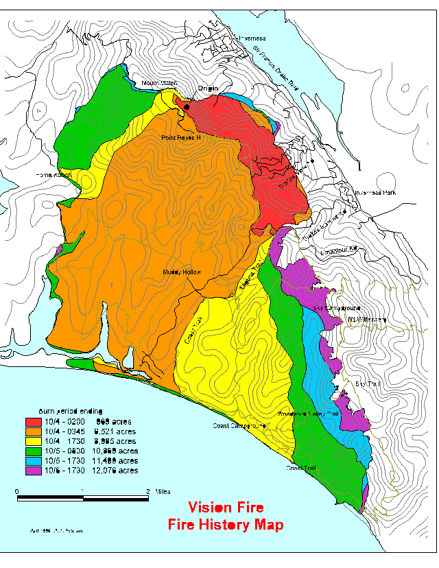
Initially, the most critical information required from the GIS lab was the fire perimeter. Twice per day, a helicopter with a GPS unit on board flew the fire perimeter, and a map was promptly produced for the fire fighters (Figure 1). Another critical datalayer was the location and condition of structures destroyed by the fire. The California Department of Forestry, Marin County Fire and NPS personnel surveyed homes in the burn area with GPS units (Trimble Navigation, Lt. ProXL and Basic Plus) and collected data on the condition and location of structures. Within four days of the fire ignition, and while the fire was still burning, these data were converted to a GIS datalayer and overlayed with a county parcel map to identify the owners of the structures.
Data were also gathered using GPS on location of hand lines, bulldozer lines, roads, trails, fire suppression effects, noxious weeds, vegetation plots, photo points, and survey points. GIS was then used for mapping, measuring, and monitoring post-fire analysis of burn effects and rehabilitation prescriptions. Examples of preliminary products generated include generalized location and identification of high to moderate burn intensity zones (Figure 2), of fire suppression measures (Figure 3), of cultural resources in relation to bulldozer lines, and of threatened and endangered species in relation to fire suppression actions. As users perceived the ability of GIS to measure and calculate information, they requested reports on acreage's, linear distances, etc.
The park had several existing datalayers including soils, DLGs, DEMs and a few U.S. Geological Survey orthophoto quads; however, crucial, missing datalayer was a digital vegetation map. A recent Landsat TM image was available but it was not ground truthed and could only be used for general reference. Instead, a vegetation map was created using the U.S. National Resource Conservation Services (NRCS) digital soils map and cross- walking this information with the associated vegetation types. This proved surprisingly useful for some of the analyses with some adjustment based on spot checking with aerial photos.
More precise and inclusive information was added to the existing GIS databases. Examples include measuring more precisely the areal extent and location of potential soil erosion sites; monitoring the spread of noxious weeds, the recovery of vegetation communities; and more accurately locating roads and trails (the USGS DLGs were inaccurate). These data were crucial in assessing fire effects and guiding rehabilitation and mitigation prescriptions.
To speed up production of maps and to assure conformity in style, specially tailored, pre-existing programs (AML's) were brought in and new ones developed. At one point, a California Department of Fish and Game Heritage Program species list of concern was plotted from the State Lands Commission in Sacramento via the internet on a plotter at Point Reyes.
HOW TO BE BETTER PREPARED
There were several challenging problems facing fire teams using GIS, and precious time was lost when problems arose. With just a little pre- planning, many of these issues could be eliminated. During informal discussions and during a debriefing meeting several months after the fire, the GIS team identified several problems and proposed solutions.
Problems:
1. GIS support was informally linked to the Incident Command structure; this led to the GIS team responding to many queries without prioritization.
2. GPS data dictionaries had to be created for field data collection.
3. AML's had to be converted to run on different platforms.
4. Problems with permission access to files on the UNIX workstations.
5. Inadequate disk workspace on the UNIX workstations.
6. Poor translation between platforms.
7. An experienced system administrator was always needed but not always present (night and day).
8. Different map projections and different scales of data.
9. Data was incomplete and sometimes out of date or of poor quality.
10. Lack of physical space for bulky computer systems, digitizers and plotters.
11. Lack of understanding of GIS capabilities by fire staff resulted in
redundant work effort.
12. A computer virus brought in on a laptop computer plagued the systems for a
couple of days before being identified and removed.
13. Non-standard file naming conventions and data categories.
14. Too many people and too few computers.
15. Lost opportunity for tracking fire history because hand drawn maps by fire fighters were lost early on as GIS lab geared up.
16. No tracking method for system administration of the workstations.
Solutions:
1. Place GIS support formally in the Incident Command System.
2. Prioritize products and place OPS first.
3. Prepackage GPS data dictionaries.
4. Prepackage AML programs for products with maps of several sizes. Ensure that the AML's can easily be transferred across platforms and are well documented.
5. Make sure that more than one person at a land management agency has GIS experience (training) and understands the capabilities and limitations of GIS.
6. Scan for viruses as new equipment is brought in.
7. Establish solid contacts with vendors so that problem solving can occur swiftly during a disaster.
8. Maintain a standard projection within the land management agency and have
the AML's to convert.
9. Keep one complete set of hard copy maps in a secure place.
10. Maintain connections with GIS specialists with other agencies, organizations and universities through conferences, societies, etc. These contacts were the key to getting the GIS lab jump- started.
11. Maintain a list of contacts with names and home phone numbers. Disasters usually occur in the evening, over the weekend or on holidays.
12. Provide a bin for placement of early hand drawn maps so fire history data is not lost.
13. Provide a log book for each workstation tracking problems and serving as a reference for team members.
14. Develop a metadata form and maintain it during the fire.
15. Schedule a debriefing meeting of GIS team shortly after the event while ideas are still fresh.
The Vision fire at Point Reyes is a wake-up call for many private and public agencies. Although it is impossible to contemplate and identify every problem in providing GIS related services during fires or other emergency operations, we are convinced that GIS is, and will continue to be, a vital tool to emergency responders in the future. It is our hope that by documenting our experiences, identifying the problems we encountered and identifying pre-planning considerations, more public and federal agencies will be better prepared to handle emergency incidents more effectively.
ACKNOWLEDGMENTS
This document represents the collective effort of personnel of the Point Reyes National Seashore and several organizations and agencies. We are particularly grateful to the Bureau of Indian Affairs, Bureau of Land Management, California Department of Forestry, California Department of Fish and Game, California Office of Emergency Services, California State Parks, Esri, U.S. Fish and Wildlife Service, National Park Service, National Weather Service, Trimble Navigation Ltd., Sun Microsystems, Inc., and a long, long list of state and county fire departments. Individuals who contributed significantly to GIS start-up and output included T. Nichols, H. Foster, J. Ganong, E. Kaufman, C. Convis, Trimble and I. Timossi. A. Peterson provided quality control of GPS files and produced many of the final maps.
REFERENCES
BAER. 1995. Mount Vision Fire incident: Burned Area Emergency Rehabilitation Plan. Dept. of Interior.
Point Reyes National Seashore 1980. General Management Plan. U.S. Dept. of Interior, National Park Service, Point Reyes National Seashore.
Point Reyes National Seashore 1993. Statement for Management. U.S. Dept. of Interior, National Park Service.
AUTHOR INFORMATION
Sarah G. Allen, Ph.D.
Ecologist, National Park Service, Point Reyes National Seashore,
Point Reyes,CA 94956, Tel: 415-663-8552,Fax: 415-663-8193, sarah_allen@nps.gov
David Kehrlein
California Office of Emergency Services, 2800 Meadowview Road, Sacramento, CA 95832, Tel: 916-262-1699, Fax: 916-262-1697
David Shreve
California Office of Emergency Services, 2800 Meadowview Road, Sacramento, CA 95832, Tel: 916-262-1455, Fax: 916-262-1697
Richard Krause
Warm Springs Reservation, P.O. Box C, Warm Springs, OR 97761, Tel: 503-553-2416