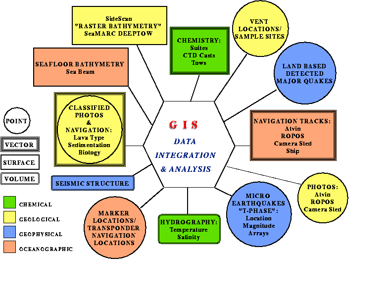
The study of hydrothermal vents involves the integration of multidiscplinary data as depicted in the organizational diagram Figure 1, of the disciplines coordinated through the VENTS GIS program. The data spans scales from the entire NE Pacific region to within a few meters of a known marker, down to the precise location of a particular vent orifice. Accuracy of a given data set is relative to the scale of the data. Integrating these data is complicated by the presence of the overlying 1000's of meters of water making visual and GPS verification of the locations impossible. Locating objects underwater often involves translating a local X-Y grid established by acoustic transponder navigation techniques into latitude-longitude coordinates. The acoustic transponder network is not a permanent fixture on the seafloor and the re-establishment of a new net with each field season always involves the reprocessing of previous data to align known features. GIS displays are used to evaluate data inconsistencies and provide quantitative information about these offsets. Once all data has been coregistered, GIS then provides the tool for integrating various data sets for analysis.
A model of the entire data collection, archiving, analysis and decision-making process in which GIS is an integral component is depicted in a scientific information model, SIM, shown in Figure 2a-c.
.
Data distribution
Data distribution via GIS is still under development at VENTS. Due to the
amount of data and constant revisions involved with these types of data,
VENTS looked for distribution via a connection to the GIS database through
ArcView. This would allow outside users who do not have access to GIS
technology to utilize the GIS functionality with the current data set. The
GUI would be customized for increased intuitive use as well as simplified by
removing unnecessary menus, tools, buttons. Users would also have the option
of saving certain data in familiar tabular formats as well as saving displays
in postscript files for replicating on their parent systems. While under
development, the current ArcView web connection has been quietly available
to researchers involved in the study of the 1993
CoAxial (web link) spreading event
eruption along the Juan de Fuca Ridge in the NE Pacific. It has been
successfully used across the country but there are some limitations. Depending
on the end-users type of web connection, the transmittal speed can be very
slow thus even further burdeoning the ArcView display and refreshal speeds.
To minimize this, the project used for the web display has been chosen to
use coverages as specific to the View and as small as possible. The other
major limitation is that only users with an XWindow display and IP address
can even access the system. Many of the CoAxial researchers use PC's and MAC's
without XWindow capabilities. Although software can be purchased for these
systems (and some have done this), many do not have funds available.
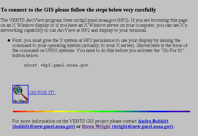
An example of the WEB page greeting to initiate VENTS ArcView is shown in Figure 3. The instructions explain that access to the GIS is only available to users with XWindow display capabilities. On UNIX systems, the host machine must be added to the .xhosts file prior further access. There are some web links for users wanting additional instructions on using ArcView and background GIS information.
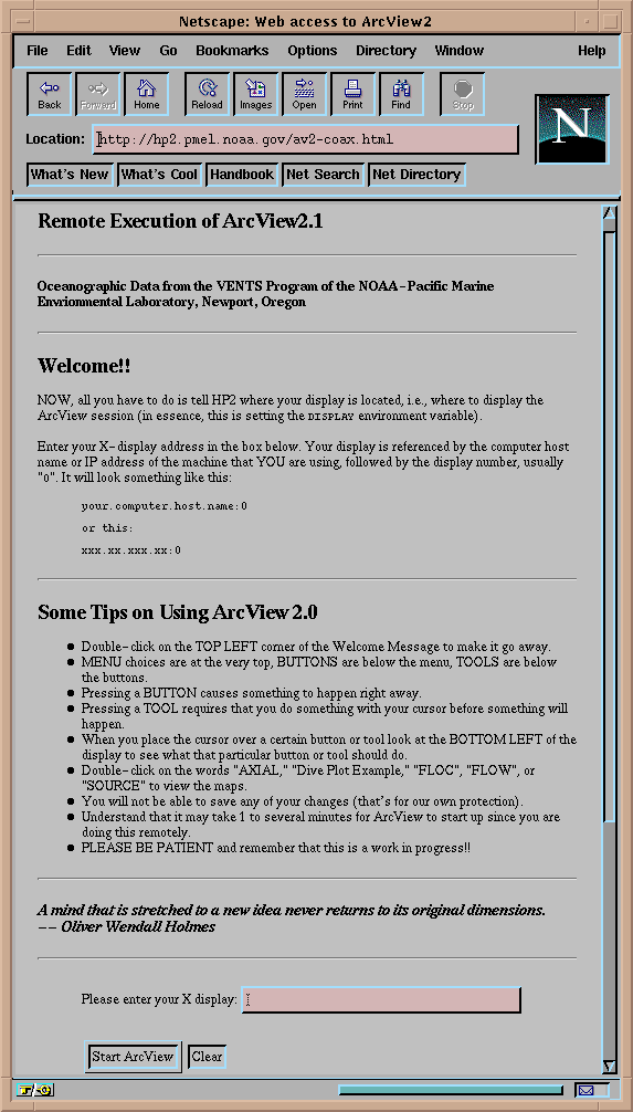
The second WEB page encountered by browsers is depicted in
Figure 4. Users are instructed to enter their IP
address with a ":0.0" extension before finally gaining access to the GIS.
The IP address is essential in order for the XWindow display to send the
proper graphics.
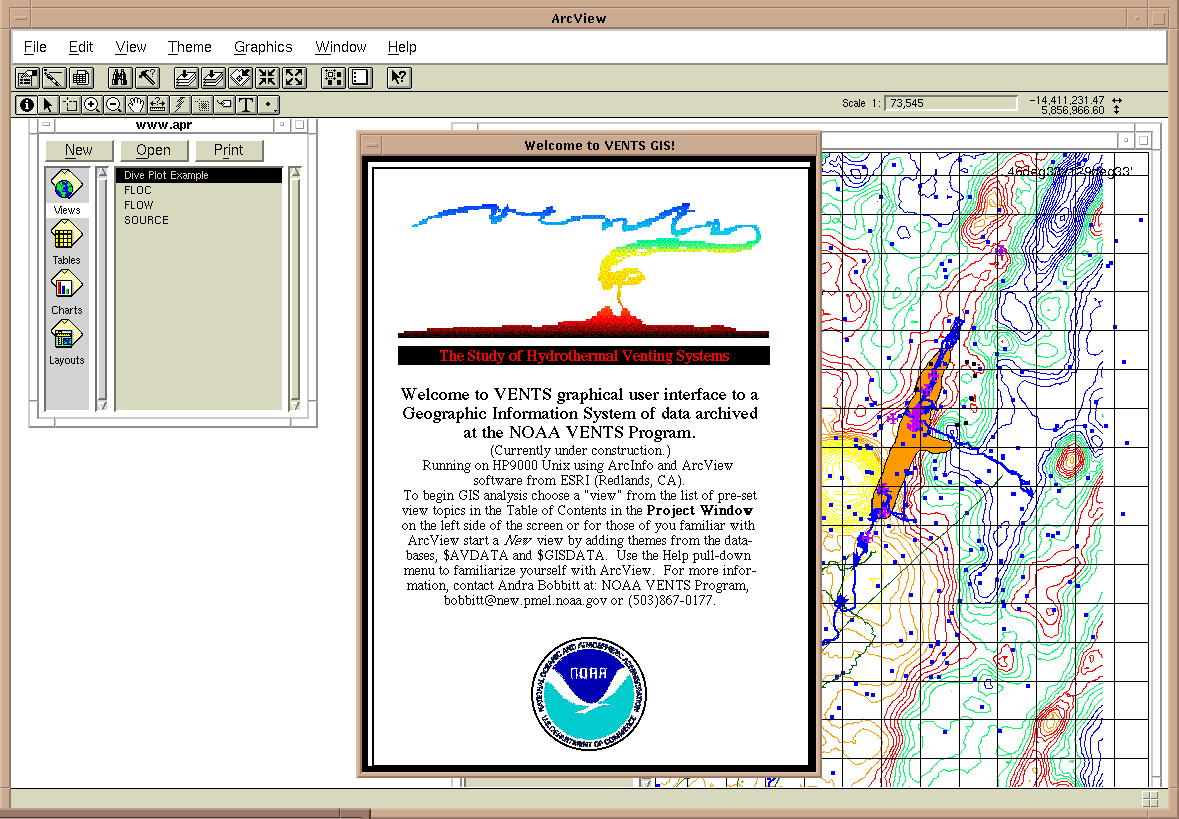
If the user has successfully connected to the VENTS GIS, the initial ArcView
project is displayed in Figure 5. A brief
message box gives some additional ArcView instructions to get the user
started.
The interactive ArcView web connection is driven by a perl script running in an html document which calls a specific ArcView project (*.apr file). The html and perl script were developed and are copyrighted by the Information Center for the Environment, UC Davis. The author is Harvey Chinn, harvey@ice.ucdavis.edu. The actual html used for the VENTS CoAxial web connection is located here. From this html, the perl script is acessed. This html can be used as a blueprint for creating other interactive ArcView-web links, changing the path and name to your specific perl script as well as other layout modifications.
The perl script is available here for downloading. This perl script can also be modified for other web connections by changing the path and filename to your specific project which will be used for web access.
.
Figure 1. Multidisciplinary data sets of the VENTS Program integrated
through GIS.
Figure 2a-c. The Vents Program Scientific Information Model.
Figure 3. Initial WEB page encountered by users attempting to access the
interactive ArcView connection. The purpose of this page is to inform
the user the connection requires the guests machine to recognize the host
machine.
Figure 4. Second WEB page requires the user's IP address for proper
transmission of the display.
Figure 5. If prior steps required by user were successful, this is the
initial ArcView project display viewed by the user.
Wright, D.J., Fox, C.G., Bobbitt, A.M., A scientific information model for deepsea mapping and sampling (web link), Marine Geodesy, in press, 1996.
Figure Descriptions
Related Publications
Christopher G. Fox
Researcher
NOAA VENTS Program
Pacific Marine Environmental Laboratory
Telephone:(541)867-0276
FAX:(541)867-3907
E-mail: fox@pmel.noaa.gov
Andra Bobbitt
Research Assistand/GIS Specialist
NOAA VENTS Program
Cooperative Inst. for Marine Resource Studies
Oregon State University
2115 S.E. OSU Dr.
Newport, OR 97365
Telephone: (541)867-0177
FAX: (541)867-3907
E-mail: bobbitt@pmel.noaa.gov
Dawn Wright
Assistant Professor
Oregon State University
Department of Geosciences
104 Wilkinson Hall
Oregon State University
Corvallis, OR 97331-5506
Telephone:541-737-1229
Fax:541-737-1200
E-mail: dawn@dusk.geo.orst.edu