SD LYNCH, NL LECLER and RE SCHULZE
Department of Agricultural Engineering
University of Natal, Private Bag X01
Scottsville, 3209, South Africa.
ABSTRACT
The science of telemetry and computer networking have made it possible for researchers to access data in real-time. Real-time hydrological data such as, rainfall and temperature, make it possible for researchers to analyse and determine what influences daily observations will have on the environment. This paper outlines the procedures of coupling, on a nationwide scale, real-time climatic data, from the approximately 400 daily reporting weather stations, with the ACRU model to produce detailed maps of inter alia soil moisture status, crop water requirements and flood-warning indicators over southern Africa. The final products are interpreted and their applications to regional and national environmental and agricultural resource plans are outlined. The methodology behind obtaining and using real-time climatic information is described in detail in the paper.
INTRODUCTION
The South African water research fraternity have always enjoyed the fact that hydrological data such as daily rainfall values are readily available from the Computing Centre for Water Research (CCWR), a multi-disciplinary organisation for water-related research. The CCWR obtains, approximately every six months, all the daily rainfall figures for the ±7000 rain-gauges covering southern Africa. The CCWR has a suite of computer programs that allow the users to check the daily rainfall values against neighbouring stations and also a suite of computer programs to infill missing daily rainfall amounts using a host of different techniques.
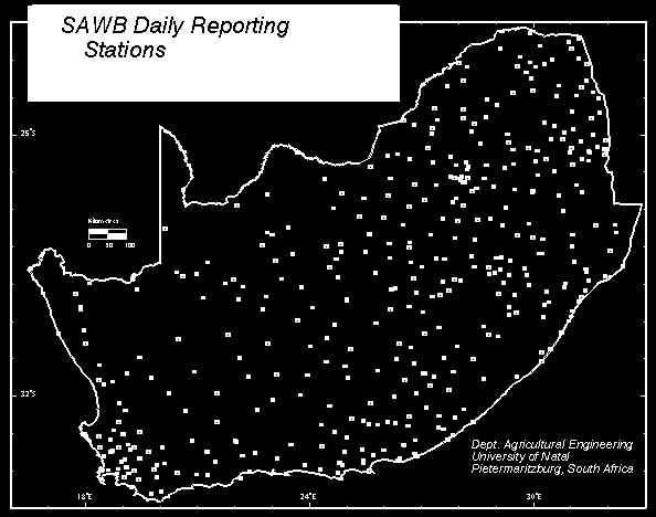
The problem that faces researchers in this modern era of hydrological computer modelling, is the availability of real-time rainfall data. The South African Weather Bureau (SAWB) has a network of ±400 daily reporting weather stations, Figure 1, that relay information to their central mainframe computer via telemetry. This paper will outline a proposed methodology that will allow researchers to do real-time modelling. Real-time will be defined to be 07h00 GMT on the previous day in this proposed methodology.
The ACRU Agrohydrological Modelling System - a multi-purpose and multi-level daily soil moisture budgeting model (Schulze, 1990) can be used to determine what the soil water moisture status is for a given catchment area. This model requires inter alia continuous amounts of daily rainfall as input. This paper will outline a proposed technique that will involve using forecasted, real- time and a more detailed rainfall network of stations.
DAILY RAINFALL FORECASTING
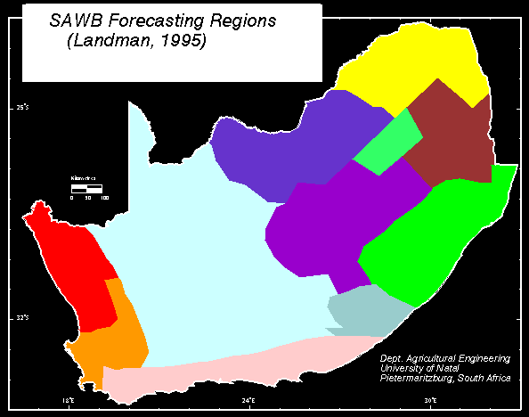
The monthly rainfall totals are used in a frequency analysis to determine percentiles of monthly rainfall. The method employed is based on a weighted average method proposed by McPherson (1990), whereby the P-th percentile, divides the data such that there is a percentage P of the rainfall totals below the P-th percentile and a percentage 100-P above the P-th percentile. Landman (1995) has divided southern Africa into 11 regions of similar rainfall, Figure 2, and has also assigned an attribute of "below normal" (B), "near normal" (N) and "above normal" (A) rainfall to each of the regions. Monthly rainfall greater than the 35th percentile and less than the 65th percentile is considered as ţnear normalţ rainfall, rainfall greater than the 65th percentile is considered to be ţabove normalţ rainfall and rainfall less than the 35th percentile is considered to be ţbelow normal" rainfall.
The rainfall totals for each of the months October through to March for the period from 1931 to the year before the season in question are searched to determine for which years each monthţs rainfall satisfied the given prediction of either N, A, or B. If a prediction category was satisfied, the preceding monthţs monthly rainfall total is then examined to determine whether it was also within its given category. The categorical limits are applied to two consecutive months because some continuity between monthly rainfall is likely (Berri, 1995).
The selected years for the months that satisfy the prediction categories are arranged in all possible combinations but in the correct monthly sequence and written to file. If for example, for each of the months, October to March, there are six years from the total data record for which the relevant monthly rainfall totals satisfied the prediction category criteria there would be a total of 46656 possible arrangements or composite monthly sequences.
The above selection results in an impractical number of possible composite sequences or "weather years" which would require the operation of computer simulation models with thousands of years of input weather information. This has the potential to use too much computer time and therefore a random sample of 100 composite sequences is selected from the set of all possible composite sequences or "weather years".
The daily weather data corresponding to the months and years of a composite monthly sequence selected from the total set of sequences are written to a file in the format of the selected modelling system.
The above mentioned procedures are used to forecast approximately six months of artificial daily rainfall amounts that are used as input to a hydrological simulation model to determine what the soil water status of the country will be. In order for the research to be practical, real-time rainfall amounts are determined and overwrite the forecasted values and when two-thirds of the forecasted amounts have been replaced, the next six-months of forecasted values are determined.
MODELLING SCALE
Southern African is a country of approximately one million square kilometres in area of which 95% receives less than 900mm of annual rainfall. The ACRU Agrohydrological Modelling System (Schulze, 1990) will be used to simulate the status of the available soil water moisture. This model requires that the area to be modelled be subdivided into distinct regions or sub- catchments. For each of these regions a daily rainfall station is selected to represent the rainfall over that region.
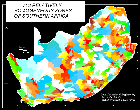
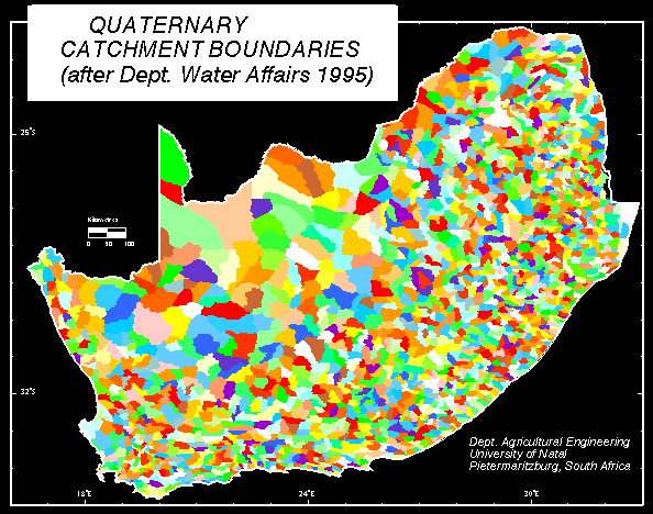
The size of these regions dictates the order of accuracy of the results and also the amount of computer time required to model the regions. A compromise between accuracy and processing speed must be reached for the successful modelling of southern Africa at a national scale. Dent, Lynch and Schulze (1989) subdivided southern Africa into 712 relatively homogenous response zones (Figure 3) and these zones were deemed adequate until Meier (1996) developed a hydrological database for each or the 1946 quaternary catchments (Figure 4) covering southern Africa.
ACQUISITION OF REAL-TIME RAINFALL AMOUNTS
The SAWB has a network of approximately 400 daily reporting weather stations that relay, via telemetry, the information to their central computer. These daily values will be downloaded automatically from the SAWB computer onto the CCWR computer, where the ArcInfo (Esri, 1995) software is situated, using the computer networks that link the different machines to each other. Lynch and Schulze (1995) found that the Inverse Distance Weighting Squared technique, using a modification proposed by Shepard (Yoeli, 1975), to be favourable in estimating areal rainfall images from point measurements. In this method weights are calculated depending on the distances between the grid node being estimated and the control or rain-gauge positions.
MODEL INPUT
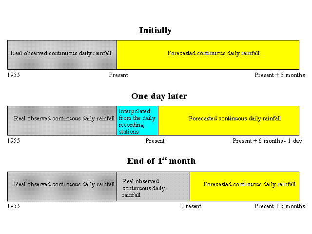
Meier (1996) has selected a representative daily rainfall station for each of the quaternary catchments and has also acquired, inter alia, temperature, soils, land-use and other hydrological information for each of the quaternary catchments. The daily rainfall for each of the quaternary catchments were selected and the missing values have been infilled (Meier, 1996). In other words, the rainfall for each of the 1946 stations have continuous daily rainfall amounts for the period 1955 till present. This period is then extended by six months using the forecasting technique and these extended rainfall datasets are used as input into the ACRU agrohydrological simulation model. Each day at 10h00 GMT the real-time daily rainfall data for the ±400 daily reporting weather stations will be downloaded from the SAWB computer and these amounts are interpolated to produce rainfall amounts at each of the 1946 quaternary stations. The ACRU model is re-run with the complete dataset. At the end of each month the daily observed rainfall data for all the 1946 stations will have been collected manually by the SAWB. The data capturing and random error analysis is then done at the SAWB before the public are allowed to access the data. This may take a day or so as the majority of these stations are recorded manually and only a very basic error check is done initially. After this monthly dataset of daily rainfall amounts have been downloaded from the SAWB computer, the interpolated values are replaced by these observed values and ACRU is once again re-run.
In other words, at first, forecasted values are used, these are then replaced daily by the interpolated values from the daily recording stations and finally the observed data replaces the interpolated values (Figure 5). When two complete months of forecasted values have been replaced by observed data, then the whole process starts again.
DISCUSSION AND CONCLUSIONS
The successful implementation of this proposed project will allow the researchers in the hydrological sciences to assist mankind in the prevention of disastrous floods and droughts. The acquisition and interpolation of real-time rainfall data will be of enormous help in filling the void in the CCWR daily rainfall data base. Modellers will also be able to simulate results to the present time and not have to publish results that are a few months or years old. The future spinoff from this project will allow researchers to link their model, directly via telemetry, to up to the minute hydrological data.
ACKNOWLEDGEMENTS
The rainfall data that formed the basis of the study was supplied primarily by the South African Weather Bureau and their contribution is acknowledged gratefully. The staff of Geographic Information Management Systems (GIMS) are also acknowledged for their assistance in using the ArcInfo software. The Research Fund of the University of Natal and the Water Research Commission are thanked for their financial assistance in this project. Finally the Computing Centre for Water Research is acknowledged for the provision of computing facilities, rainfall data and for assistance with computing.