Abstract:
An ArcView application has been developed by Environmental Systems Research Institute (Esri) for the Metropolitan Water District of Southern California (MWD). It selects MWD facilities that fall within a specified distance from the epicenter of an earthquake. With this new ArcView application multiple users can monitor earthquakes. ArcView reads a file that is being written to the Banyan Vines network by a program called Seisport. (The Seisport program and documentation were developed for the California Institute of Technology by Peter T. German Geophysical Consulting.)
Seisport is a message receiving application used to monitor near realtime earthquake broadcasts. Seisport receives CUBE (Caltech / USGS Broadcast of Earthquakes) format earthquake messages using a receiver connected to a computer and saves the received information in a disk file. Seisport also includes user configurable alarms to alert users of seismic activity that exceeds preset response criteria. Seisport is a DDE aware program capable of passing earthquake data to any other application running on the same computer.
CUBE is a project operated jointly by the California Institute of Technology Seismological Laboratory (Caltech) and the United States Geological Survey (USGS) Southern California Seismic Network. The CUBE Project is organized under the Caltech Earthquake Research Affiliates Program, administered by the Caltech Office of Earthquake Programs.
In the past decade, southern California has experienced 16 damaging earthquake sequences. At today's valuation, potential property losses may be well over one trillion dollars following a large earthquake, and the threat to human life cannot be quantified. Because of the enormous impact that earthquakes can have on economic and public safety concerns, decisions about response are necessary after every significant earthquake. The effectiveness of those emergency response decisions is determined by the ability to access critical information immediately following the earthquake. Accurate assesment of the earthquake's impact on an organization's infrastructure will dictate what level of response, if any, is necessary to prevent further damage or loss of life.
Prior to 1990, information about an earthquake which had just happened was received mainly via commercial radio and television news broadcasts. Accurate locations and magnitudes were frequently not available to those managing emergency response for an hour or more. This time delay meant that critical information arrived after the decisions had been made. In 1990, the California Institute of Technology (Caltech) in cooperation with the United States Geological Survey (USGS) began a pilot project to report earthquake information in near-realtime. Private industry, as well as state and county governmental agencies, participate in the Caltech USGS Broadcast of Earthquakes (CUBE) project by annually contributing to Caltech's Earthquake Research Affiliates (ERA) program. The CUBE project transmits the time, location, and magnitude of earthquakes in southern California within four minutes of their occurrence.Since reliable information is now available within minutes, emergency response managers can easily prioritize deployment of their resources based upon the location of their facilites relative to the epicenter of the earthquake. This allows for a more efficient and cost effective use of repair and maintenance personnel.
Caltech and the USGS jointly operate a network of seismic monitoring instruments which continuously relay ground motion information to the Seismological Laboratory in Pasadena. The network is made up of both analog and digital seismometers and strong ground motion instruments located at approximately 250 sites throughout southern California, and is collectively known as the Southern California Seismic Network (SCSN). This network is the source of the data broadcast by the CUBE system.
Data from the SCSN is analyzed in order to determine the time, location, and magnitude of earthquakes in southern California. For earthquakes of magnitude 4.0 or greater, peak ground acceleration measurements are recorded to determine the spatial extent of strong ground shaking during the earthquake. The data is then transmitted via commercial paging companies to emergency response personnel at ERA/CUBE partner organizations. The average time for notification is four minutes from the time of the earthquake.
Most of the ERA/CUBE partners have an extensive network of facilities or physical property throughout southern California. Some examples of ERA/CUBE partners are power, water, and gas companies with extensive pipeline and/or power lines extending over very wide areas. Other examples of ERA/CUBE partners include railroad companies and the California State Department of Transportation (Caltrans). Most of these organizations are ERA/CUBE partners because, in the event of sustained interruption of services brought on by a large earthquake, they would face major financial losses. By providing crucial earthquake information immediately, including location, magnitude, and territory that experienced the most severe ground shaking, managers can prioritize the dispatch of emergency response personnel.
ERA/CUBE partners also save money by knowing when not to respond to an earthquake. Mobilization of personnel is an expensive operation. By knowing precisely where an earthquake occurred, its magnitude, and the regions that experienced the most severe ground shaking, ERA/CUBE partners know when to deploy emergency response teams and when to keep them at home. In the past ten years there have been 16 damaging earthquake sequences in southern California, but there have been an additional 412 earthquakes which were widely felt, but which caused little or no damage. ERA/CUBE partners have saved money by not deploying emergency response resources in response to these earthquakes. Over the last six years, the experiences of ERA/CUBE partners with CUBE have enabled Caltech/USGS scientists to develop CUBE to better serve the needs of our partners.
The data is transmitted to AirTouch Paging using the TAP protocol over a dedicated radio link. This is to ensure that the data will be received by the AirTouch in the event that the telephone system is overwhelmed after an earthquake. The message is then broadcast to Motorola Advisor pagers, capable of receiving and displaying alpha-numeric data. The pagers are equipped with a serial interface that is normally used for programming the pager, which we exploit to receive the data from the pager when a message is transmitted. The pager sits in a cradle that provides a standard RS232 signal which is fed into a serial port on a personal computer.
The data is captured from the serial port via a program called Seisport. (The Seisport program was written by Peter T. German Geophysical Consulting.) Seisport is a Microsoft Windows compatable program which records the earthquake data into a file that can be accessed by other programs. Seisport can also pass data to other programs running on the same machine via DDE. Seisport has built in alarms to notify users of earthquakes which meet or exceed user specified alert levels.
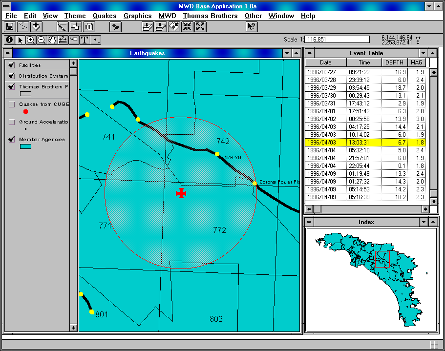
The application is basically comprised of 2 views and 2 main quake tables. There is a main view, used as a primary detail view to which all themes are added, and an index, or locational, view that displays an overview of MWD's Southern California service area. The 2 tables are populated from the CUBE system file as it is updated by the broadcasts or as the user wishes to re-import. The event table contains one record for each quake epicenter and contains date, time, depth, magnitude, and location description information. A ground motion table is also created as the CUBE file is read, containing information about ground motion at the various siesmic stations in Southern California, and may or may not be related to a specific quake event identified in the event table. The quake epicenters and ground motion stations are added to the main view as event themes when the CUBE file is read by the application.
When the user starts the application, the event table is displayed along with the main and index views. Specific data that a user may wish to view in relation to the seismic activity may be added as themes to the main view and remain highlighted. When the user clicks on a record in the event table, the main view zooms to a 3-mile radius around the selected event. The radius is displayed as a red circle, and features from the highlighted theme that fall within that radius are selected and labeled.
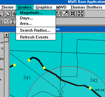
The user may wish to define certain criteria for displaying the quake epicenters based on magnitude, area of interest, or time span. Initially, these variables have default values. During startup, All quake events of magnitude 0 or greater occuring within the last seven days within a 10-mile radius of MWD's service area are read into the event table. The default search radius around a selected epicenter is 3 miles. With the Main View active, the user defines quake event display criteria by choosing the 'Quakes...' pulldown option on the menu bar. The 'Magnitude...' input field requires the minimum magnitude value of events be added to the table. The 'Area...' choice will query the user to choose whether to show all events or only those within MWD's service area. The 'Days...' choice will prompt the user to enter the maximum number of days past in which the events have occured (i.e, a value of 7 would display all quakes within the last 7 days). A radius distance around a selected event is entered in miles by choosing the 'Search Radius...' option. Once these criteria are redefined, the 'Refresh Events...' option will re-create the event table with those records from the CUBE file that meet those criteria.
The CUBE application is an extension that is loaded into the Base Application. An extension consists of a Loader Script, ODB of Scripts, ODB of GUIs, and ODB Application Dictionary which stores all of the application specific settings. Of course your loader can load any other documents specific to your application. The Base Application acts as an "Application Manager". All applications have a prefix that is used to make its scripts and GUIs unique to that extension. For example, all of the CUBE scripts are prefixed with CUBE.
Since ArcView 3.0 will support extensions, special care has been taken in order to upgrade this application when ArcView 3.0 becomes available. ArcView 3.0 will allow us to do even more with the extensions at MWD in the future.
Metropolitan's water serves to supplement locally produced water. Metropolitan imports half of all the water used in the area; the rest mostly comes from locally produced groundwater. However, although some areas rely mostly on their own water supplies, others depend on Metropolitan for nearly all of their water. Accordingly, Metropolitan needs a reliable water delivery system.
Obtaining a reliable delivery system in a geologically-active area is important because water is the utility that will be needed most following an earthquake. Meeting this need challenges Metropolitan. The distribution system crosses many active faults, including the famous San Andreas Fault (see figure). The San Andreas, the source of the anticipated "big one," will shift as much as 20 to 30 feet. Such fault movement would damage any pipe crossing it, no matter how well designed. In addition, the pipes must cross many lesser, yet still significant faults. Many of these faults have potential movements of 15 feet, which would also damage any pipe crossing them. Furthermore, as the Northridge and Kobe earthquakes showed, many faults go undetected until after they move.
However, fault crossings are only one of the earthquake risks that Metropolitan encounters. Another hazard to distributing water in a geologically-active area is that the surrounding mountains erode almost as fast as they grow. This rapid erosion means southern California consists largely of loosely consolidated soils, which could liquefy with shaking. This liquefaction will likely cause more widespread pipe damage than just at the site of fault rupture.
Given these hazards and the importance of water, Metropolitan works to assure a reliable water system. The CUBE earthquake reporting system helps Metropolitan obtain that reliability.
First off, having earthquake data available on network file servers throughout the organization reminds every employee using ArcView of the importance of earthquakes in the day-to-day planning, engineering, and operation of the distribution system. These hazards are very real and the more Metropolitan's employees recognize and respond to these vulnerabilities, the more reliable the distribution system will be and the more capable Metropolitan will be in responding after an earthquake.
Secondly, it serves as a "teaser" to get employees to use ArcView. Many people want to learn about earthquakes and with the ArcView/CUBE interface, they can learn about quakes as quickly as they happen. The first thing most people do when they jump onto ArcView is search for the most recent earthquake. The second thing they do is look for their home. As they do, they learn about the other GIS data available through ArcView. This use of the GIS fits with Metropolitan's goal of making all kinds of GIS data available and used throughout the organization.
The real power of a GIS interface to the CUBE earthquake data comes in superimposing the quake data, as it occurs, over information about Metropolitan's distribution system and the region's geology. Obviously, knowing where the earthquake faults cross the distribution system is important for the planners, engineers, and operators. With available GIS data, Metropolitan can also superimpose areas of soil liquefaction hazards, coupled with pipe construction information, therefore identifying likely locations for leaks following significant ground shaking. By using this information and the ground acceleration data broadcast by CUBE, Metropolitan's operators can set priorities for inspecting pipes for leaks. This analysis is possible in Metropolitan's Emergency Operations Center, staffed with operators familiar with ArcView.
Another example of the analysis possible with CUBE and ArcView is Metropolitan's Business Resumption Plan. This plan looks at the long-term recovery following a major earthquake, as opposed to the Emergency Operations Center, which looks at the short-term reaction to a quake. Following a devastating quake, Metropolitan will have to resume operation of many tasks. For example, Metropolitan purchases power to pump water from the Colorado River. Due to the tremendous amount of power required (three percent of the power used in California), these purchases need to be scheduled with the major power purveyors. Following a devastating quake, Metropolitan's power schedulers need to continue to arrange for power. The Business Resumption Plan maps the home locations of key employees so that a manager can determine who might be available for scheduling if the prime scheduler is unavailable.
3.0 How Metropolitan Uses CUBE and ArcView
To understand how Metropolitan uses the data from CUBE, let me first introduce Metropolitan. We supply water to much of southern California: from Ventura County to the Mexico border, and from the coast to inland San Bernardino and Riverside counties. All total, the service area contains 5200 square miles, six counties and sixteen million people.4.0 Conclusion
The provision of earthquake monitoring data from Caltech and USGS greatly helps a utility such as Metropolitan Water District to respond following an earthquake. ArcView's ability to compare the earthquake data with Metropolitan's water distribution facilities allows the system operators to set priorities for damage inspections. This ability to respond intelligently and quickly after an earthquake has immense value to Metropolitan.
Steve Bryant
Director of Technical Support, CUBE
Seismological Laboratory
California Institute of Technology
Division of Geological and Planetary Sciences
Phone: (818) 577-0665
FAX: (818) 564-0715
Email: steve@bombay.gps.caltech.edu
Karen M. Luethke
Manager
California Institute of Technology
Office of Earthquake Programs
Phone: (818) 395-3298
FAX: (818) 584-1242
Email: karen_luethke@starbase1.caltech.edu
Peter Jacobsen
Engineer
Metropolitan Water District of Southern California
Phone: (213) 217-7923
FAX: (213) 217-6119
Email: pjacobsen@mwd.dst.ca.us
Larry Boden
Environmental Systems Research Institute
Phone: (909) 793-2853 ext. 1381
FAX: (909) 793-5953
Email: lboden@Esri.com
Eric Bader
Environmental Systems Research Institute
Phone: (909) 793-2853 ext. 1931
FAX: (909) 793-5953
Email: ebader@Esri.com