Bruce Rindahl

Analysis of Real-Time Raingage and Streamgage Flood Data Using ArcView 3.0

Abstract

The City of Aurora's Utilities Department is utilizing ArcInfo and ArcView to analyze and display real-time raingage and streamflow data from the city's ALERT Flood Warning System. ERSI's ArcView was chosen to display rainfall and streamflow data because of its ability to display numerous types of GIS information, Avenue script customization, spatial data analysis, file input- output, remote system execution, and graphical user interface. ArcView 3.0 Spatial Analyst is used to develop a continous areal rainfall surface from the point rainfall data. The Utilities Department is able to access and analyze both historical and current real_time rainfall and streamflow data from a easy to use graphical interface. Data is obtained by querying a remote real-time data collection database. Applications include studies in emergency flood response, location of flood reports, routine maintenance for storm sewers, and NPDES compliance for water quality. This paper will lay out the steps in the development and use of this tool including remote system calls, Avenue script customization and project display.

Introduction

The City of Aurora is a community of approximately 247,000 located in the southeast Denver metro area. Aurora is the third largest city in the State of Colorado. Since 1988 the City of Aurora has devolped, along with the Urban Drainage and Flood Control District (UDFCD) a real-time flood warning system utilizing raingages and streamgages throughout the Denver metro area. The system is commonly known as ALERT (Automated Local Evaluation in Real Time) and was originally developed by the National Weather Service in Sacremento, CA. Numerous private vendors have since developed software to collect and analyze ALERT data. The ALERT gages transmit via radio signals to a base station located in the City of Aurora Utility Department (and other similar base stations). Through this system real-time rainfall and stream stage is monitored remotely for the entire metro area. Figure - 1 shows the location of the gage network. In addition to real-time data, the base station software also archives all data so historic records can be analyzed.

GIS Coverages

USGS DLG files were obtained for roads, lakes, and streams for the Denver metro area. These are used as the basis for the background coverages to display the rainfall and streamflow data. The individual raingage and streamflow gages were located by map coordinates and generated as a point coverage in ArcInfo. Attributes were added to the point coverages for additional information such as ID number and name and location of the gages. Finally, drainage basins were digitized as polygons from drainage maps for later analysis.
Rainfall Location Map

Figure 1 - ALERT Raingage Location Map


Obtaining Real-Time Rainfall

An Avenue script was developed to query the ALERT base station computer for real-time (or historic) data. Time steps (1 hour, 1 day, etc.) are saved as global variables from a menu item in ArcView. A button then executes a script to request the selected information from the ALERT base station via a remote shell command over the City of Aurora's network. The rainfall data is returned in the form of a ASCI text table to the machine runing ArcView. The script then joins the text table to the rainfall point coverage using the ID field (included in the ALERT table). ArcView then displays the rainfall on the active View using the Auto-Label feature. This entire process takes approximately 20 seconds with most of the time taken by the ALERT base station to process the request. Historic data can be displayed in an identical fashion. Figure - 2 shows the rainfall depths in Aurora for the storm event that occured June 6 1991.
Rainfall Depths

Figure 2 - Rainfall Depths From the June 6, 1991 Storm


Utilizing ArcView 3.0

The City of Aurora obtained a beta release of ArcView 3.0 from Esri to investigate the additional analysis tools available in this product. The results have been outstanding especially for this application. After the rainfall data has been joined to the point coverage, the spatial analyst can be used to fit a smooth grid through the raingage points giving a full two-dimensional surface to the rainfall distribution. While the estimation is only as good as the data to develop it, the method can give greater insight to the actual rainfall pattern. Figure - 3 shows a rainfall surface from the June 6 1991 storm.


Rainfall Distribution

Figure 3 - Rainfall Surface From the June 6, 1991 Storm


Once the rainfall surface is computed, estimates of rainfall including maximum, minimum and average depth of rainfall by drainage basin are instantly obtained using the procedure Summarize by Zone built into ArcView 3.0. These values could then be used for hydrologic models to compute runoff and flood potential. Figure - 4 shows the Table obtained for drainage basins located in Aurora form the June 6 1991 storm.


Rainfall Summary

Figure 4 - Summary Table of the June 6, 1991 Storm by Drainage Basin


Areas of Further Study

At the time of the deadline for this paper, the City of Aurora has only been working with ArcView 3.0 for two weeks. While the relults have been exceptional so far, aditional potential for the application to Real-Time rainfall analysis is tremendous. Some further areas of study include:
  • Calibration/Correction of Raingage Data using Wind Field Measurements
  • Comparison of Rainfall Surfaces to Radar Images
  • NPDES Sampling Criteria based on Rainfall Events
  • Hydrologic Analysis of Storm Events
  • Comparison of Predicted Runoff with Streamgage Data
  • Animated Displays of Storm Events

    Summary and Conclusions

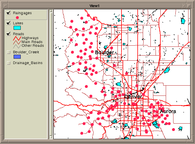
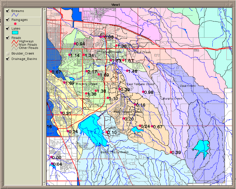
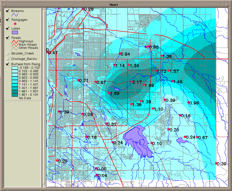
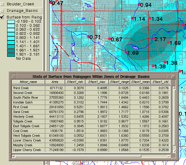
    Through the use of ArcView 2.1 (and the future release of ArcView 3.0) the City of Aurora can now analyze and display real-time rainfall data from the city's ALERT flood warning system. The Utilities Department is able to access and analyze both historical and current real_time rainfall and streamflow data from a easy to use graphical interface. This allows for a better and clearer understanding of a particular storm and allows more complex analysis of the true impact of the event. There is tremendous future potential for more applications from this technology.

    Appendix

    Sample Script for Retrieving Raingage Data
    
    system.execute("remsh flood reportgen -g37 -FtTpt/aview_update.tpt n=1 s=1d >/tmp/temp.txt")
    theView = av.GetActiveDoc
    theTheme = theView.FindTheme("Raingages")
    theFTab = theTheme.GetFTab
    theFtab.UnjoinAll
    newVtab = VTab.Make("/tmp/temp.txt".AsFileName,FALSE,FALSE)
    Field1 = theFTab.FindField("Raingages-id")
    Field2 = newVTab.FindField("Id")
    theFTab.Join(Field1,newVTab,Field2)
    Field3 = theFTab.FindField("Value")
    theTheme.SetLabelField(Field3)
    

    Author

    Bruce Rindahl, Senior Water Resources Engineer (Primary & Presenting Author)
    City of Aurora, Utilities Department
    1470 South Havana Street
    Aurora, CO 80012
    Phone: (303) 695-7383
    Fax: (303) 695-7491
    E-mail: brucer@dilbert.ci.aurora.co.us