The National Wetlands Inventory's First Two Years on Internet
by
Herman Robinson, Computer Systems Analyst
National Wetlands Inventory US Fish and Wildlife Service
St. Petersburg, Florida 33702
Bill Wilen, Project Leader
National Wetlands Inventory
US Fish and Wildlife Service
Washington, D.C. 20240
OVERVIEW
The National Wetlands Inventory (NWI) of the U.S. Fish and Wildlife Service produces information on the characteristics, extent, and status of the Nation's wetlands and deepwater
habitats. This information is used by Federal, State, and
local agencies, academic institutions, Congress, and the private
sector to formulate resource management objectives and myriad
other applications. The Emergency Wetland Resources Act of 1986
directs the Service to map the wetlands of the lower 48 states by
1998, and Alaska by 2000. The NWI has mapped 87% of the lower 48
states, and 30% of Alaska. The Act also requires the Service to
produce a digital wetlands database for the United States by
2004. About 33% of the lower 48 states and 11% of Alaska are
digitized. Congressional mandates require the NWI to produce
status and trends reports to Congress at ten-year intervals. In
1982, the NWI produced the first comprehensive and statistically
valid estimate of the status of the Nation's wetlands and wetland
losses, and in 1990 produced the first update. In addition to the
status and trends reports, the NWI has produced over 130
publications, including manuals, plant and hydric soils lists,
field guides, posters, wall size resource maps, atlases, and
state reports, and has had numerous articles published in
professional journals.
BUILDING THE DATABASE
The NWI National Center in St. Petersburg, Florida, includes a
state-of-the-art computer operation which is responsible for
maintaining the wetlands layer of the National Spatial Data
Infrastructure (NSDI). The NWI maps are digitized by contractors
and other Federal, State and University mapping organizations.
Once the data pass quality control reviews, they are integrated
into the wetlands layer of NSDI. All digital files are
constructed with 100% user-pays funding from cooperating agencies
or contributed by other organizations that digitize the existing
NWI maps. Cooperating and contributing agencies included 48
Federal, Native American Tribes, State, county agencies, and
private sector organizations such as Ducks Unlimited. Statewide
databases have been built for 8 States and initiated in 5 other
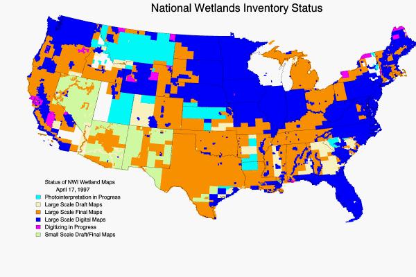
States. Digitized wetland data are available for portions of all
50 States (Figure 1). Once digital data
is added to the database, users can download the data at no cost
over the Internet, or purchase the data through the U.S.
Geological Survey for the cost of reproduction. NWI maintains a
MAPS database of metadata containing production information,
history, and availability of all maps and digital wetlands data
produced by NWI. This database us available over the Internet.
The six U.S. Geological Survey Earth Science Information Centers
(ESIC) regional offices have on-line access to the database; a
subset of the database is available on disk for use on personal
computers.
The Emergency Wetlands Resource Act requires the NWI archive
and disseminate wetlands maps and digitized data as it becomes
available. The process prescribed by Office of Management and
Budget (OMB) circular A-16, "Coordination of Surveying,
Mapping, and Related Spacial Data", provides an avenue for
increased NWI coordination activities with other Federal agencies
to reduce waste in government programs. As chair of the Federal
Geographic Data Committee's Wetlands Subcommittee, the NWI
Project Leader is responsible for promoting the development,
sharing, and dissemination of wetlands related spacial data. NWI
continues to coordinate mapping activities under 36 cooperative
agreements or memoranda of understanding.
Hard copy NWI maps are being archived for perpetuity by the
National Archives. NWI maps and digital data are distributed
widely throughout the country and the world. The NWI has
distributed over 1.7 million maps nationally since they were
first introduced. Map distribution is accomplished through 34
state-run distribution centers covering 47 States; the U.S.
Geological Survey centers at 1-800-USA-MAPS: the Library of
Congress and the Federal Depository Library System; and most
recently the NWI Home Page on the Internet. The URL address for
the Home Page is: http://www.nwi.fws.gov.
Currently, over 20,000 digital maps are available at no charge
over the Internet.
DISSEMINATING DIGITAL WETLAND DATA
Over a period of 13 years before Internet, NWI sold 37,996
digital wetland data files through USGS's 1-800-USA-MAPS. These
maps were and are sold through a tired pricing plan. The average
cost per map file was $9.20. The data is still being offered. NWI
met the April 1995 deadline of providing public access to
geospatial data sets in President Clinton's Executive Order 12906
(Coordinating Geographic Data Acquisition and Access: The
National Spatial Data Infrastructure). Anyone with access to a
GIS system and the Internet can download the data. During the
first two years 163,570 digital wetland map files were
downloaded. At the average cost of $9.20 per map file, users have
saved over $1.5 million dollars but in reality it expanded use of
the data.
Paper Maps vs. Digital Files
Although the total number of hard copy paper maps distributed
far exceed the number of vector data files distributed, the shift
from paper copies of maps to the vector data files of the
wetlands is well under way. (Figure 2)
illustrates the shift that has occurred between 1991 to 1996.
This slide does not include the Paper copies of the maps that are
distributed by the 34 State run centers covering 48 states, or
the maps that are used in microfiche formate in the 600 map
depository libraries. On the digital side this graph does not
include the date provided through what we call the
"Everything Tape." For those people who can utilize a 5
Gigabyte 8mm UNIX tar tape, NWI sells what we call the Everything
Tape for $155.00. It contains all the data in the database on the
day the tape is cut, and is sold through the USGS Earth Science
Information Centers.
Users
Maps are used by all levels of government, academia, Congress,
private consultants, land developers, and conservation
organizations. Users by domain are displayed in (Figure 3). The unresolved users are people
who did not provide a valid e-mail return address. The biggest
user is the government. (Figure 4)
provides an additional breakdown on government users. The single
biggest individual government user is the Lawrence Livermore Lab.
Other big users are EPA and the U.S. Geological Survey. The users
do not stop at our international boundaries. Wetland files were
downloaded by users in 43 countries from Argentina to the
Ukraine. (Figure 5) shows the biggest
international users were Canada, the Netherlands, and the United
Kingdom.
Uses
The uses are even more varied than the users. They include
planning for watershed and drinking water supply protection;
sitting a transportation corridors; construction of solid waste
facilities; and sitting of schools and other municipal buildings.
Resource managers are provided with maps which are essential for
effective habitat management and acquisition of important wetland
areas needed to perpetuate migratory bird populations as called
for in the North American Waterfowl and Wetlands Management Plan;
for fisheries restoration; floodplain planning; and endangered
species recovery plans. Agencies such as the Department of
Agriculture use the maps as a major tool in the identification of
wetlands for the administration of the Swampbuster provisions of
the 1985,1990 and 1995 Farm Bills. Regulatory agencies use the
maps to help in advanced wetland identification procedures, and
to determine wetland values and mitigation requirements. Private
sector planners use the maps to determine location and nature of
wetlands to aid in framing alterative plans to meet regulatory
requirements. The maps are instrumental in preventing problems
from developing and in providing facts that allow sound business
decisions to be made quickly, accurately, and efficiently. Good
planning protects the habitat value of wetlands for wildlife,
preserve water quality, provides flood protection, and enhances
ground water recharge, among many other wetland values.
NWI's Homepage
The NWI's World Wide Web site provides access to much more than wetland map files.
NWI Homepage also includes the following sections:
But as evident in (Figure 6), the
users are after data.
Wetland Files Downloaded
The first two years saw 163,570 wetland files downloaded. The
most download in one day was 1996 files, but the average was 224.
The only day during the first year that maps were not downloaded
was Thanksgiving day. This was not the case the second year (Figure 7). During the furlough of the
Federal government in 1996, nearly 1,000 maps a day were
downloaded. In the past NWI maps were disseminated every business
day. Now digital wetland map data files go out almost every day
of the year. Figure 8 shows transfer by
hour of the day. (Figure 9) shows
transfer by day of the week. Most people download 1 to 5 files
per visit (Figure 10) but 48 users
downloaded more than 500 files during one visit. The digital
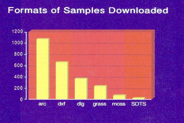
wetland data are served in DLG format. NWI sample files in other
formats, (Figure 11) are also served.
Our goal was to see what the interest was in other formats. ARC
sample files are the most downloaded followed by DXF. Users of
autocad systems need data in DXF format. The small amount of NSDI
sample data downloaded seem to indicate that it has not yet
caught. The small amount of metadata transferred (Figure 12) was also a surprise. It appears
that after people take a look at your metadata and understand
what you are serving they don't bother use the other information.
(Figure 13) provides data on other map
related files that were transferred. Software is also provided on
NWI's Homepage to assist users. AMLs and SMLs for converting NWI
DLG files to ArcInfo, unzipping software, parsing software and a
public domain version of TAR for MS-DOS are all provided. (Figure 14) indicates which types of
software are the most popular.
Additional sources of data are maintained by the NWI to
complement the information available from the maps themselves.
The Service maintains a National List of Plant Species that Occur
in Wetlands. This list has been incorporated into the Federal
Manual for Identifying and Delineating Jurisdictional Wetlands,
and in to the Natural Resources Conservation Service's procedures
to identify wetlands for the Swampbuster provision of the Farm
Bill. The National List and Regional Lists are available over the
Internet through the NWI Homepage.
CONCLUSION
Serving data over Internet represents a major milestone for the NWI Project. It has provided an optional means for making digital wetlands maps and related data available to users around the world.