Teresa Bennett
Developing the Palm Beach County Special Drainage District
Atlas
The development of the Palm Beach County Special Drainage
District Atlas is a result of the October 1995 floods. During
and after this disastrous flooding event District personnel found
it difficult to locate flooding complaint calls.
The Operations & Maintenance Department's GIS unit worked with
the State of Florida, Palm Beach County, and the nineteen Special
Drainage Districts to locate, map and place into GIS, boundary
and water control structure information for each of the special
districts.
Information contained in the Atlas has been put into an automated
GIS application which allows District personnel to type in the
caller's address, find the caller's location, and then provide
general information about the drainage district the call falls
within.
Prior to the development of the Special Drainage District Atlas
it typically took thirty minutes to handle a call. It now takes
approximately one minute.
DEVELOPING THE PALM BEACH COUNTY SPECIAL DRAINAGE DISTRICT
ATLAS
FLOOD CONTROL IN SOUTH FLORIDA - A COMPLEX SYSTEM
Unlike many other states where one entity is usually responsible
for providing local and regional drainage for the community,
Florida is more complex. Some areas have no formal drainage
systems and are prone to routine flooding; others may be covered
by several organizations or governments providing varying levels
of service. Depending on conditions, water may have to be routed
through a number of interconnected, though independent,
conveyance systems - each of which must be properly maintained
and functioning - in order to provide flood protection for
central and south Florida neighborhoods.
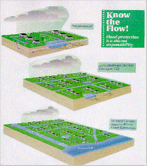 KNOW THE FLOW
A failure or blockage in one part of the system can adversely
affect others. Proper drainage can be compared to a chain of
dominoes; one out-of-sync piece can slow or stop the chain. The
SOUTH FLORIDA WATER MANAGEMENT DISTRICT (SFWMD) and local
drainage districts (aka Special Drainage Districts) spend
millions of dollars each year to maintain these vital water
conveyance systems; smaller community facilities must be
maintained by homeowner associations.
THE NEED FOR A SPECIAL DRAINAGE DISTRICT ATLAS
Even the best-maintained and functioning drainage systems cannot
totally prevent flooding. In fact, flooding will always occur
during heavy, prolonged downpours and hurricanes. South Florida
experienced a disastrous flooding event in October 1995. The
SFWMD received hundreds of flooding calls. District personnel
found it difficult to locate these calls or to determine if a
Special Drainage District's canal was involved. Hence, the
development of the Palm Beach County Special Drainage District
Atlas.
DEVELOPING THE SPECIAL DRAINAGE DISTRICT ATLAS
The Operations & Maintenance Department's GIS unit worked with
the State of Florida, Palm Beach County, and the 19 Special
Drainage Districts to locate, map, and place into GIS, boundary
and water control structure information for each of the special
districts. Much of the information needed was available only in
paper format or non-ArcInfo formats.
The names of all active Special Drainage Districts in Palm Beach
County were obtained. The SFWMD GIS team made appointments with
each of these districts and sat down in person to deliniate their
jurisdictional boundaries, identify canals, and locate water
control structure sites. The personal contacts made in these
meetings were invaluable. Discrepancies in boundary lines between
Special Drainage Districts were brought to light, forcing
managers to work together to accurately determine who maintained
what. Everyone was excited about the prospect of having all the
Special Drainage District boundaries mapped and stored in one
place.
Most all information obtained by the Special Drainage Districts
during the first contact stage was global; the GIS team would be
provided with a medium scale, limited detail wall map showing
that district's boundary line and other pertinent information. It
was agreed in the project's design phase to create the atlas
using a scale familiar at the SFWMD and one that would allow the
detail needed; namely, USGS 7.5 minute quad scale of 1:24000.
The wallmap information was transferred into GIS at the quad
scale as best could. A second meeting with the special districts
gave them the opportunity to approve and in most cases correct or
enhance the information shown at the more detailed quad scale. As
many as four iterations were made per special district before
final approval.
Simultaneously while Special Drainage District boundaries were
being mapped the SFWMD GIS team was busy designing the layout of
the atlas as well as searching for other information needed.
Palm Beach County has an established GIS, and SFWMD was fortunate
to obtain crucial basemap information from them. Some of this
information resided in AutoCad, however, and had to be converted
to ArcInfo. One bonus for the GIS team was that Palm Beach
County had already indexed their detailed streets with
section-township-range cells. The cells had been attributed with
an alpha column and numeric row designation. The same
section-township-range cells were used in the Palm Beach
County Special Drainage District Atlas enabling the GIS team to
utilize Palm Beach County's street index. This index became the
basis for locating entities in the atlas.
Before designing the layout of the atlas, the GIS team first had
to determine the main purpose and focus of the atlas. During the
aforementioned flood event in 1995 it became apparent that
personnel manning the SFWMD's phone bank needed a better method
of locating where flooding was occuring and which canals were
involved. With that in mind the team decided that an
alphabetical street index approach similar to that of a road map
would be best to locate incoming calls. The
section-township-range street index obtained from Palm Beach
County was used to determine in which grid cell(s) the caller's
street is located. The index, nothing more than a large textfile,
was plotted on sheets of paper the size of USGS 7.5 minute quad
sheets and inserted at the beginning of the atlas. Had this
data not been available an overlay of the section-township-range
grid cells, or some other form of a grid, and the attributed
road coverage would have been executed. A report of the street
name and grid cell letter/number would have been extracted to
create the street index textfile.
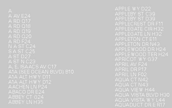
STREET INDEX EXAMPLE
A Street Locator Index was next designed. This index shows the
entire county and the USGS 7.5 minute quadrangle boundaries
within it. Plotted on top of this are the aforementioned
section-township-range grid cells with their letter/number
attributes depicted along the top and the righthand edge of the
paper.
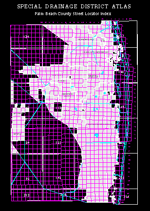
STREET LOCATOR INDEX
Using the street index textfile to determine which grid cell the
street falls within, you locate that particular grid cell (A1,
A3, D12, etc) on the Street Locator Index map. This will in
turn inform you in which quad sheet the grid cell can be located.
You then turn to that quad sheet in the atlas for the detailed,
blowup page of the area. Again, the grid cell letter/number
attributes are depicted along the top and righthand edge of the
detailed quad sheet so that you can narrow in to the requestor's
explicit area.
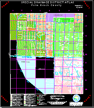
DETAILED QUAD ATLAS SHEET
Features shown on the detailed quad pages include primary and
secondary canal systems, primary and secondary water control
structures, Special Drainage District boundaries, SFWMD critical
facilities, and of course the detailed street network. Once the
caller's street is located on the map one can see immediately in
which Special Drainage District they are located and what
canal(s) may be causing problems. This information allows the
SFWMD to contact the Special Drainage District involved and work
hand-in-hand with them to alleviate the problem.
With the main pieces of the atlas created, the GIS team decided
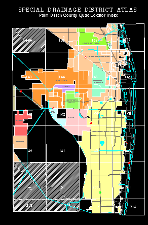
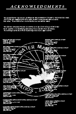
what other informational sheets would be helpful. Three more
pages were created; namely, a Quad Locator Index showing in which
quads a particular Special Drainage District falls within, a
Special Drainage District address page, and a How to Use
This Atlas page.
QUAD LOCATOR INDEX
ADDRESS PAGE
CONCLUSION
This atlas was created out of a need to better serve the public
during heavy storm events. However, since its creation numerous
uses for it have surfaced. The SFWMD Control Room references the
atlas almost daily. The Control Room monitors the 1800 miles of
canals and levees the District maintains and operates. In the
course of their normal work day, personnel in the Control Room
receive numerous calls from the public with concerns varying from
who maintains the canal behind their house to why a particular
pumping structure is releasing water. Likewise, the District's
West Palm Beach Field Station also receives numerous calls from
the public. In the past, it would take District personnel up to
an hour to respond to the caller with the answer to their
question. With the publication of this atlas, the response time
has cut back substantially. Recognizing that this type of
information greatly increased service to the public, an ArcView
address matching application mimicking the paper atlas was put
into place at both the field station and the control room. Now
what typically took 30 minutes to an hour to handle takes
approximately one minute.
Teresa Bennett
Staff Georgrapher
Operations & Maintenance Department
South Florida Water Management District
P. O. Box 24680
West Palm Beach, FL 33416-4680
Telephone: (561) 687-6055
Fax: (561) 681-6232
 KNOW THE FLOW
 KNOW THE FLOW


