The PMRF range is the largest instrumented multi-environment range in the world. It consists of broad ocean areas to the north, south and west of the Island of Kauai. This translates to one thousand square miles of instrumented underwater range and over 42,000 square miles of controlled airspace. Water depths range from 400 to over 2,500 fathoms.
Range operations include a multitude of actions conducted by various assets such as planes, ships, submarines, targets, interceptors and missiles moving in concert with each other based on a test scenario. To some extent these assets operate as independent entities while the overall operation makes them interdependent until the scenario is complete.
In some cases ships or airplanes that are not part of the exercise fail to heed broadcasted alerts/notifications and intrude into the test area. The dangers resulting from this type of action can be serious. They range from being relatively minor such as impeding the progress of the exercise to the more serious extreme of the intruder being in harms way. Sources of danger could come from either one of the monitoring assets as it maneuvers, falling debris from a live missile firing as it runs through it's launch and flight sequence.
If detected, an intruder into the range area during a test scenario will result in the suspension of operations or the shifting of all assets associated with the operation away from the unwanted visitor. Since a suspension of operations normally results in a large negative cost impact to the sponsoring program, the option of choice is the shifting of assets in such a manner so as to continue to accommodate the planned scenario.
Another concern of the PMRF range is that of the environmental impact that some of the range operations may have on areas within and surrounding the range. The prediction of debris spread from a planned interception or as the result of a missile shot going off path is critical to environmentally sensitive areas. These predictions must consider a multitude of variables including altitude and weather conditions.
The PMRF model was built to support Range Safety for both the automated generation of firing scenarios and, if necessary, redeployment/realignment of associated assets during an exercise. Additionally, consideration for debris spread predictions and environmental impact study support was also factored into the model's capabilities. The possibility of the model accepting live feeds from radar and other PMRF range sensors was also researched. In order to support these model requirements multiple level object display had to be supported in real time.
Preparation of data, creating the 3D models
The prototyping of the user interface
The design of the trajectory model
The coding of Avenue programs by which the application was implemented
The primary function of the application was to demonstrate the functions and potential applications of GIS technology to track multiple objects at multiple levels in a simulated real time mode. Since the model was built primarily as a technical demonstration data complexity and accuracy was not a primary concern. Basic geographical data and 3D models were created on Digital Chart of The World (DCW) data and DNC bathymetric data.
The software utilized for the processing of data and developing the PMRF applications is ARC/VIEW and the 3D Analyst extension. ARC/VIEW 3D Analyst supports Triangulated Irregular Networks (TINs). TINs are vector based, topologically structured models that have desirable characteristics for representing terrain and other surfaces. 3D Analyst supports the creation of TINs from feature themes in a view. Selected records from active themes are used as input. This methodology enables the user to visualize, via the view display, what will be used to create a TIN prior to processing. TIN files can also be created via the ArcInfo command "CREATETIN".
The ARC/VIEW 3D Analyst extension also supports simple 3D vector geometry through new shape types. These include points, lines, and polygon patches. X, Y and Z coordinates are stored for every point and vertex. The shapefile format was extended to support 3D shapes thus providing a mechanism for the storage and distribution of simple 3D geometry.
There are several methods by which 3D shapefiles can be created. 3D Analyst now allows for the creation of 3D shapefiles directly from 2D themes utilizing an attribute to interpret the Z value. The Z value can also be interpolated from underlying surface themes. New 3D shape objects and requests have also been added into the Avenue language, for example "pointZ.make", "polylineZ.make", and "polygonZ.make".
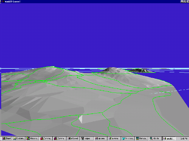
Figure 1 TIN Surface Models and Streets
As noted previously, the headquaters and primary operation control and instrumentation area is located at Barking Sands which is located along the western shore of Kauai island, Hawaii. The operational areas are displayed in Figure 2. They include aerial and target recovery, gunnery exercise (M1), BARSTUR area (M2), primary instrumented operational area (M3), extended range areas for large scale operations (M6-M8) and participant holding area and extended range areas (M5-M7).
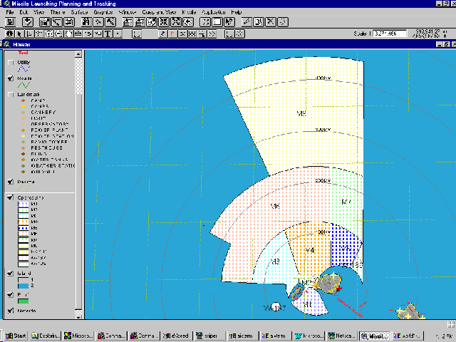
Figure 2. Operation Area and Test Range
The application provides query functions and view tools to allow users to query on both geographical information and also tabular data relating to the facilities, environment, streets and utilities (Figure 3).
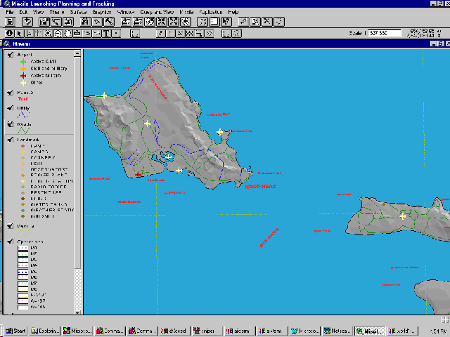
Figure 3 Geographical Information and Feature Data
The application also simulates the scenarios of operational planning, track planning, real time tracking and off-track testing (Figure 4).
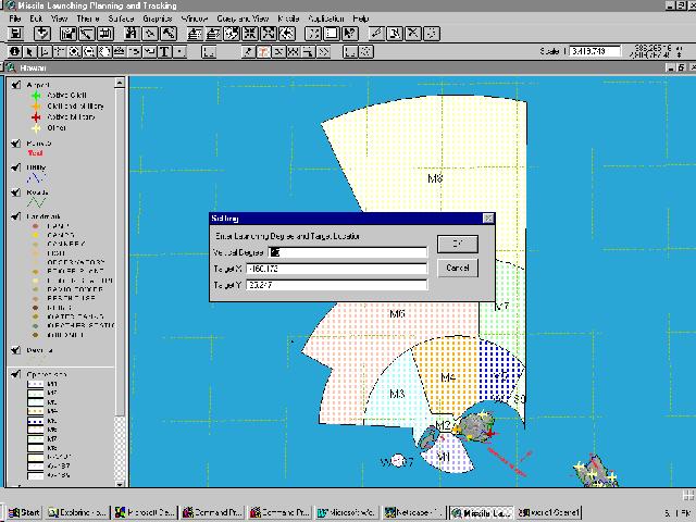
Figure 4 Place a Target
Operation of the model for scenario generation can be accomplished via one of the tool buttons or by data selecting a position on the range and entering the latitude and longitude in degrees into the pop-up. The target location will be displayed on both the 2D and the 3D presentations (Figure 5).
After the target is located, the system calculates trajectory using a simplified mathematical model. The trajectory model is created based on an ellipse curve function with consideration given to the vertical launching angle and coordinate shift conditions. The application also provides the operator with tools which simulate an interception exercise. The missile target area and an estimated interception point are selected by the operator as are speeds for the objects and the launch point for the interceptor. The model will then calculate the possibility of interception based on the current settings and locations. The possibility of interception depends on the speed of the target missile, pre-defined preparation time, maximum allowed interceptor speed, the locations of launching sites and the intersection point. The operator will be alerted if one of the variables is such that the exercise will result in a missed interception. If the preliminary test succeeds, the system will plot the trajectories of both missiles (Figure 5).
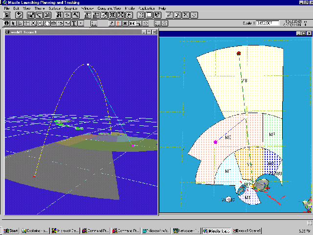
Figure 5 Trajectory of Target Missile and Interceptor
The system also provides the options and tools for planning aircraft tracks that may be used for sensors during the firing. These tools allow the operator to create an aircraft track by drawing the polyline on the ARC/VIEW map. The editing tools associated with this function allows the user to move and rotate the track. The current implementation of the system can track multiple aircraft, conduct the missile firing and interception exercises simultaneously.
The system can also simulate the real time tracking of all active components of the scenario as they travel on their pre-defined paths in both 2D and 3D projections. The 3D projection can be rotated, tilted and zoomed to enhance viewing of the presentation.
As an additional feature, the PMRF model provides a function that emulates a real time debris zone which is created by either target interception or missile impact in the target area. An expansion factor associated with the debris area allows for growth of the area over time. The expansion area's growth can be modified to take other environmental factors into consideration as part of the predicted debris spread. The debris area is also displayed in both the 2D and the 3D presentation (Figure 6).
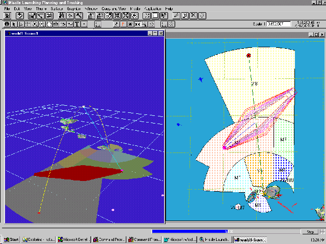
Figure 6 Debris Zones After Interception
Finally, an off-track scenario has also been implemented. A buffer zone (Safety Zone) is created around the pre-defined track of the missile firing. If for some reason the missile fails to maintain course within the related safety zone of the firing the model will alert the operator and destroy the missile. A debris pattern is projected and expanded as a function of time after the destruction.