Forest Land Use Assessment with GIS in Virginia
Rei Liu
Virginia Department of Forestry
Abstract
In 1992, the Virginia Department of Forestry began a long term assessment of Virginia's forest resources. This assessment differs from past assessments in its emphasis on population growth, land use change and
the implications of these land use changes to the forest resource. A report on the initial phase, which fo cused on timber supply, was completed in 1995. Geographic Information System (GIS) technology was used to overlay population density patterns with forest land cover and land use data. The expert opinions of local Department foresters were then used to choose threshold population densities that could be used to separate forestlands into two categories: "rural" forestland, which is likely to remain available for long term timber production; and "urban" forestland which is likely to become unavailable for timber production through residential or other development, at least by the time the existing forest reaches economic maturity. Estimates of timber volumes, growth, and removals for rural forestland were derived from the 1992 Forest Inventory and Analysis (FIA) for Virginia data. Areas of rural forest unsuitable for harvest because of steep slopes, small acreage or distribution in narrow strips were removed from consideration to leave the "suitable rural forestland" that is expressed to support future commercial timber production in Virginia. This paper demonstrates a method to integrate GIS and Forest Inventory Analysis (FIA) data to identify forest resource availability information and to recommend the ways for the state forestry agencies to use this information in better managing their forest resources. This project is exploratory in nature with a primary focus on developing analysis tools useful for the statewide forest resource assessment.
Introduction
In 1992, the Virginia Department of Forestry (VDOF) decided to make a concerted effort to develop a system to assess the impact of the growing suburban and rural populations on the timber resource of Virginia and to show spatially, using Geographic Information System (GIS) technology, where this impact is occurring. A committee was established to investigate the sources of data, methods of analysis, and potential output products. The committee recommended using readily available 1970s USGS Land Cover/Land Use data, 1990 Census data, and the 1992 Forest Survey for Virginia (Johnson, 1992). The land cover/land use data would provide the forested areas of the state, the Census data would allow to evaluate the impact of population on the availability of forestland for economic purposes and the Timber Survey data would further refine the impact of population on forest resources data. The GIS technology was employed to examine how urban and suburban growth may influence the location and intensity of forest management, to assess the land availability for various forest practices in Virginia and provides a practical means for accomplishing these assessments on a large scale. This paper demonstrates the initial efforts to assess the location, character and probable availability of forests in Virginia to support a strong economy. Subsequent reports following this paper will cover assessments relating to additional aspects of the Department's mission (Liu, 1995). Of primary concern is the fact that rapid population growth increases demands on forest resources even as it decreases the amount and availability of forestland. There are obvious needs both to conserve forestland and to improve its productivity.
Methods
Data Collection
Data were collected and developed in a manner that allows comparison within the state. The principal data sources for this project were 1990 US Census 1:100,000 population by block, 1990 USGS 1:100,000 Digital Line Graph (DLG), 1992 USFS Forest Survey for Virginia and 1:250,000 USGS 1970's land use and land cover data.
U. S. Census population data was used to define population density threshold zones. The population density was calculated by square mile in the Census block. Different population density levels were generated by GIS operations to help experts and local foresters choose threshold population densities that could be used to separate forestlands into "rural" and "urban" forestlands.
U. S. G. S. land use and land cover data would provide the forested land areas of the Commonwealth. This data was refined by our experts and local foresters using recent aerial photographs.
DLG data includes three levels of roads (primary, secondary and connector roads), streams and ponds. These data were used to define the buffer zones and riparian lands. The preliminary mapping of the resource consisted of the foresters hand drawing on grid maps. These maps were compared with Census and USGS data.
Forest Inventory data was obtained from the Sixth Forest Survey for Virginia (Johnson, 1992), U. S. Forest Service, Southeastern Forest Experiment Station, Forest Inventory Analysis (FIA), Asheville, NC.
Geographic Information Analysis
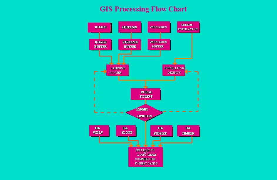
Two plausible tracks for addressing objectives of the project have been defined. One relies on GIS analysis using existing spatial data to define the primary "rural" forestlands in the study area, which is the timberland inside census blocks with "rural" population densities (Liu, 1994). The ArcInfo GIS was used to perform this spatial analysis. The GIS operation includes spatial union, erasing, map joining, buffering, etc. The other approach relies on expert opinion (from local foresters) to refine and delineate the areas where commercial forest management most likely could be practiced in the near future based on the GIS generated information (see Figure 1).
Figure 1. GIS Spatial Analysis for Potential Commercial Forest Lands
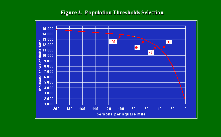
 Population density was plotted against timberland area to identify the thresholds. The relationship of population density and timberland area is shown in Figure 2. Geographic distributions of several population densities were superimposed on land use and land cover data along with roads, streams and political boundaries to produce maps representing "urban" and "rural" forestlands. On a county basis, thresholds of 38, 46, 64 and 100 persons per square mile (psm) were examined to produce maps which seemed to best divided timberland into rural and non-rural categories. These maps were then reviewed by local Department foresters who choose the population density threshold that best characterized their impression of local conditions. The primary criterion for classification was the subjective probability that particular forestlands would remain undeveloped and available for harvest beyond the current rotation; that is, "rural" forestland would have a high probability of being available for harvest of the current stand and of the next, whereas "urban" forests were unlikely to be available for harvest beyond the existing stand, if at all. Finally, local foresters revised the maps by hand where they felt that large areas of forestland had been misclassified based on USGS land use/cover and Census population density data.
Figure 2. Population Thresholds
 Integrating Forest Inventory Analysis Data into GIS An independent assessment of forest land and population interactions was conducted by using the 1990 Census and the Sixth Forest Survey for Virginia, completed in 1992 by the U.S. Forest Service, Forest Inventory Analysis (FIA), Southeast Forest Experiment Station, Asheville, NC. The geographic information analysis created maps of rural and non-rural forest lands. The limitations of this forest resource assessment on timber inventories can be examined by looking at the data from the Sixth Forest Survey for Virginia.
The FIA data do not include any measurement of surrounding population densities. In this analysis, population data were incorporated by coding each forest inventory plot with a population density from the 1990 Census. ArcInfo GIS overlay procedures were used to identify the census block in which each FIA plot was located. The forest plot was then assigned the population density of that census block.
Once "rural" and "urban" forestlands were classified, it was possible to segregate and evaluate forest survey plot data separately for these two classes of forestlands. The first class of forestland was additionally screened to classify forests which, while rural , were probably unsuitable for harvesting. Three criteria were used to eliminate forest stands which were: (1) less than five acres in size; (2) found on slopes over 40 percent; or (3) narrow strips or stringers. Data for the remaining rural and "suitable" timberlands were then used as the best basis for estimating future timber supplies.
Growing stock volumes and annual growth of softwoods and hardwoods on these rural, suitable forestlands were used to characterize potential timber supply and were compared with average annual removals to indicate the status and regional variability of timber growth and drain in Virginia.
Results and Discussion
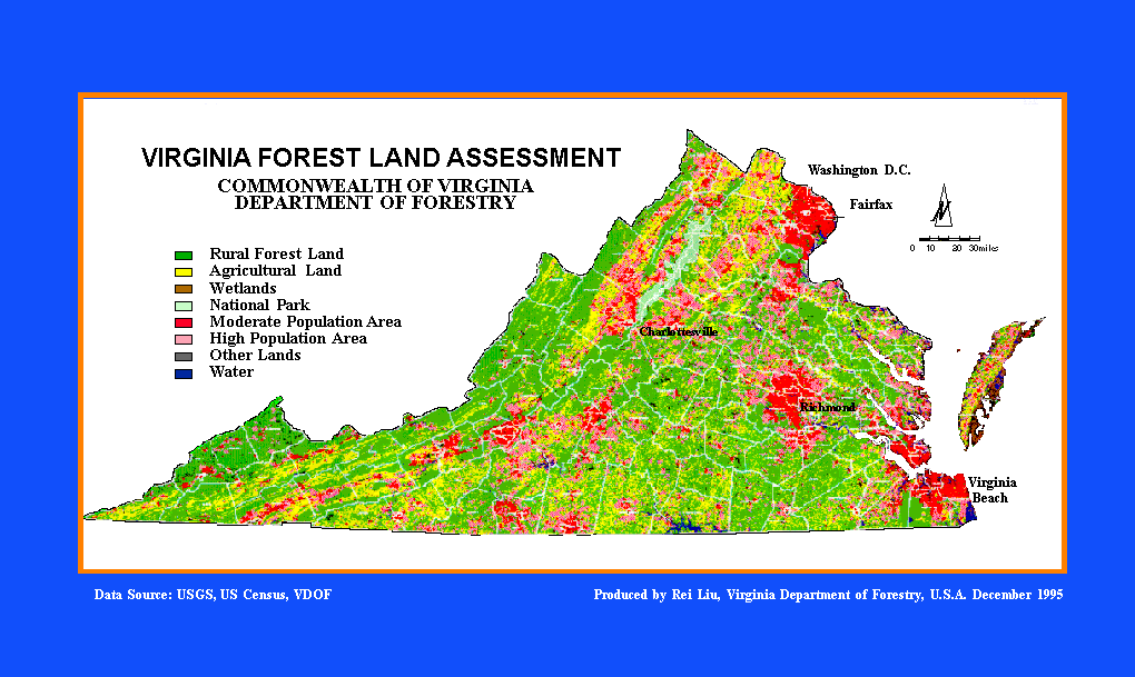
The GIS overlay processes produced a set of forest land use assessment maps for Virginia State. These maps includes 1: 400,000 statewide forest land assessment map and various scales of forest land use maps for 22 Virginia State Planning Districts and counties. Some sample maps are given in Appendix. GIS Process provided very important forest resource spatial information for forest decision makers.
As showed in Figure 2, while the population thresholds varied by county, a statewide threshold about 52 psm would have given the same acreage. Using a statewide threshold of 70 psm would have given another 900,000 acres, a threshold of 100 psm an additional 700,000 acres.
Population densities chosen by local foresters as appropriate thresholds for separating urban from rural forestlands are used by county. Four densities, 38, 46, 64 and 100 persons per square mile, were sufficient for classifying all forestlands of the Commonwealth. Additional local modifications were made in only a few instances. Results of this classification by county are included in the project report (Liu and Scrivani, 1995).
Of the 7,312 inventory plots in Virginia, 4,559 were classified as forested and these included data from 95,716 trees. The forested area of Virginia was estimated to be 16.0 million acres, of which 15.4 million acres fit the formal definition of "commercial timberland;" that is, land not currently developed for non-forest use, not legislatively withdrawn from timber production and capable of producing at least 20 cubic feet of wood per acre per year.
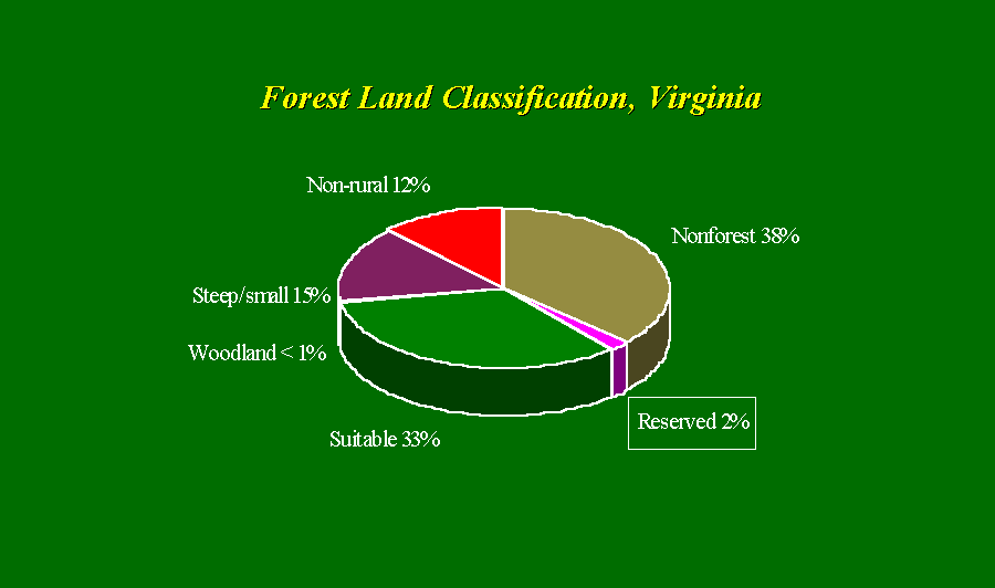
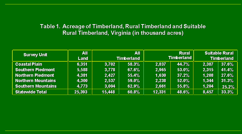
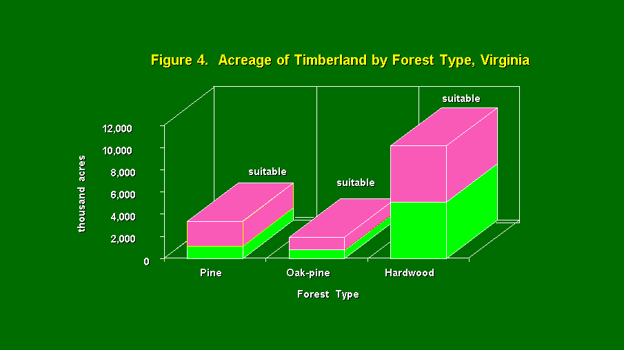
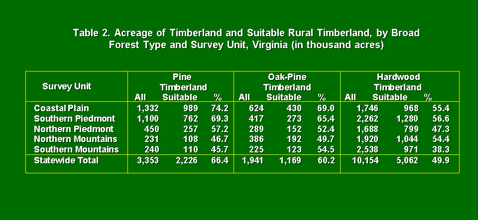
Reclassification of this 15.4 million acres placed 3.1 million acres in the urban forest category and left 12.3 million acres as rural forestland. Rural forestland included 3.8 million acres that were unsuitable for harvesting operations applying the three criteria of stand size, slope and stand operability. This leaves 8.5 million acres of suitable, rural forestland to support forest industry in the Commonwealth. The distribution of this land is shown by survey unit in Table 1 and Figure 3. Related details concerning timber supply and demand are summarized in Tables 2 - 4 and Figures 4 and 5.
Figure 3. Forest Land Classification in Virginia, 1992
 The classification of timberland by availability can also be applied to broad forest cover types. Figure 4 and Table 2 present the results applied to pine, oak-pine, and hardwood types. The results of this further analysis showed a reduction of 1.1 million acres of pine, 800 thousand acres of oak-pine, and 5 million acres of hardwood forest, which are respectively, 34 %, 40% and 50% reductions.
Figure 4. Acreage of timberland by forest type in Virginia, 1992
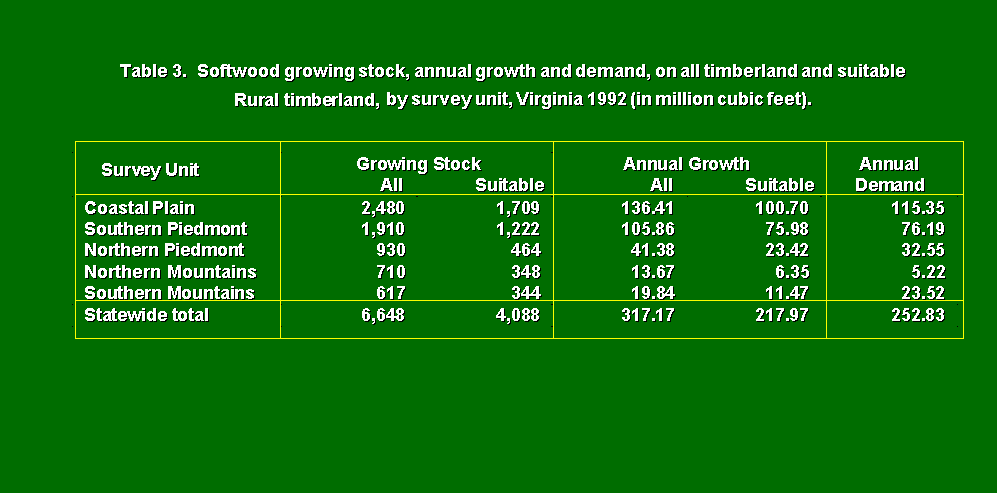
The volume of wood found in each classification of timberland was also estimated, and separated into softwood and hardwood volume. The inventory of standing wood volume which is considered capable of being made into commercial forest products is called growing stock. The growth of wood accumulating on this inventory annually is called growing stock growth. The annual removals of wood from this inventory is called demand. Estimates of growing stock inventory, growth and demand were computed using the 1986-1991 forest survey plot data. Hence, inventory estimates are for 1991, and growth and demand estimates are annual averages for the period 1986 to 1991.
Softwood growing stock inventory on the "rural suitable" timberland is 2.6 billion cubic feet less than the total of 6.6 billion cubic feet found on all timberland, a 39% reduction (see figure 3). Annual softwood growth on "rural suitable" timberland is 218 million cubic feet, a 31% reduction from the annual growth on all timberland. Softwood demand (average annual removals 1986-1991) is 253 million cubic feet Hence, cubic foot growth on suitable timberland lags behind demand by 14%.
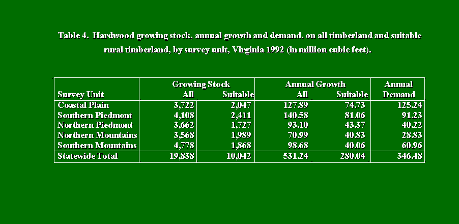
Hardwood growing stock inventory in the "rural suitable" timberland is 9.8 billion cubic feet less than the total of 19.8 billion cubic feet found on all timberland, a 49% reduction. Annual hardwood growth on "rural suitable" timberland is 280 million cubic feet, a 47% reduction from the annual growth on all timberland. Hardwood demand is 346 million cubic feet. Cubic foot hardwood growth on suitable timberland lags behind demand by 19%.
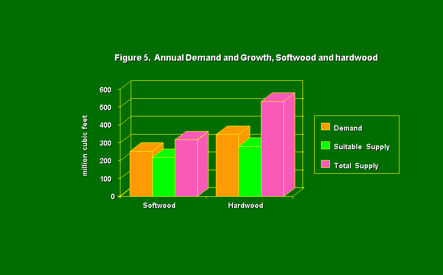
These tables show some important differences across the Commonwealth. The southern piedmont and coastal plain regions have long been considered the "wood basket" for Virginia, particularly in softwood supply. When all timberland is considered "available" in this two regions, softwood growth exceeds demand by 18% and 39% in the coastal plain and southern piedmont units, respectively. When population and other factor are used to reduce the available supply, growth lags behind demand by 13% in the coastal plain and is roughly equal to demand in the southern piedmont.
The southern mountains unit shows a 16% softwood growth deficit without factoring reductions in timberland availability, and a 51% deficit with. White pine removals account for 60% of the softwood removals in the southern mountains. The northern mountains unit shows the most favorable growth to removals ratios, but is usually among the lowest in absolute levels of inventory, growth and demand.
At least three phenomenon occurring since 1991 have acted to decrease inventory and growth. An epidemic of southern pine beetle killed a large, but poorly quantified, portion of the softwood growing stock. Ice and wind storms in 1993 and 1994 have reduced both the softwood and hardwood inventory. Forest products tax data for 1992, 1993 and 1994 have all shown considerable increases in demand (removals). The 1994 data show an increase over the 1986-1991 average of 29.4 % for softwood demand and 18.5% for hardwood demand.
Conclusions
After a century or more of continued renewal of Virginia's forest resource, several factors are acting to change that trend, perhaps dramatically. Since 1976, the amount of forested land in Virginia has been relatively stable. However, with population growth, urban and suburban sprawl, and changes in forest ownership, the forested landscape has become increasing fragmented and less available for commercial forest management. A geographic information system (GIS) analysis has shown that 3.1 million acres of the 15.4 million acres classed as commercial timberland can no longer be considered rural enough to allow management for forest products. Rural forestland included 3.8 million acres that were unsuitable for harvesting operations applying the three criteria of stand size, slope and stand operability. This leaves 8.5 million acres of suitable, rural forestland to support forest industry. These area of rural forestland represents one-third of the Commonwealth.
As the initial results of mapping effort were evaluated, several important points became apparent. The results show that the data used for this project are relatively stable and reliable for the statewide analysis, and the refining process by expert opinion is necessary, especially in those transitional areas from "rural" to "urban". It is becoming more possibly that the Forest Inventory Analysis data can be integrated into GIS to determine forest land availability for commercial use. The correlation between more people-less trees is obvious but the mapping process in this project has really brought out this relationship more clearly. The GIS, as a decision-making support tool, provides a practical means for accomplishing these assessments on a large scale. The mapping process demonstrated in this paper is a efficient way to assess the location, character and probable availability of forests in Virginia to support a strong economy.
Acknowledgments
The authors would like to thank James A. Copony, Timothy C. Tigner and J. Michael Foreman who assisted in developing this document. Special thanks to Mr. James Garner, Virginia State Forester, for his comments and support on this project. The authors also wish to thank VDOF staffs, regional foresters and county foresters for reviewing and commenting on the maps developed from this project, and thanks to Pauh Wang for his assistance on GIS map preparation.
Literature Cited
Hansen, Mark H. , 1992, The Eastwide Forest Inventory Data Base: Users Manual, General Technical Report, U. S. Forest Service, North Central Forest Experiment Station, 1992 Folwell Avenue, St. Paul, Minnesota 55108.
Johnson, Tony G. 1992, Forest Statistics for Virginia, 1992. Resource Bulletin SE-131, U. S. Forest Service, Southeastern Forest Experiment Station, P.O. Box 2680, Asheville, NC 28802.
Liu, Rei and John A. Scrivani, 1995. Virginia Forest Land Assessment, Forest Resource Assessment Project Report: Economic Phase, Virginia Department of Forestry, P.O. Box 3758, Charlottesville, VA 22903.
Liu, Rei, 1994. Guidelines, Operating Procedures and Standards of Using Geographic Information System (GIS) for Forest Land Assessment, Technical Report, Virginia Department of Forestry, P.O. Box 3758, Charlottesville, VA 22903.
Appendix:
Virginia Forest Land Assessment Map
Rei Liu, Ph.D.
GIS Coordinator
Virginia Department of Forestry
P.O. Box 3758
Charlottesville, VA 22903, U.S.A.
Telephone:(804) 977-6555
Fax: (804) 296-2369