City of Los Angeles - Department of City Planning
Zoning Information and Map Access System (ZIMAS)
Co-authors:
Easing Chen
Fred M. Ige
Contents
Introduction
GIS and Land Development in the City of Los Angeles
Zoning Data Conversion
ZIMAS Overview
ZIMAS Pilot Development
Hardware and Software
Prototype Design
Windows-Oriented Application
User Objects
Future Development
Internet
Database Design
Introduction
The Department of City Planning (DCP) has been operating a manual and semi-automated zoning information system for over 70 years. Its public counters rely on 1888 zoning maps, which are stored on paper and microfiche, to provide legal zoning information. DCP plans on automating all its zoning maps, but must determine the scope of a major commitment. An automation pilot, referred to as the Zoning Map Automation (ZMA) Pilot Program, was initiated in late 1995 to estimate the resources required to complete a citywide Zone Map Automation program.
Two groups were assembled to assess two major components of the pilot. The Pilot Map Conversion Team was assigned to determine the complexity and approximate cost of a citywide Geographic Information Systems (GIS) Map Conversion Project. The Zoning Information and Map Access System (ZIMAS) Team’s mission was to test current technology to display automated zoning information with an easy-to-use data retrieval format. This paper will discuss the data conversion process, and will identify technical issues relating to applications design, development, problems and solutions encounter by the ZIMAS Team.
Using Map Object 1.0 and PowerBuilder 5.0 on a Windows NT 3.51 platform, DCP has developed a live demonstration of parcel-level mapping for the Northridge community of Los Angeles. Since this is a pilot project and the amount of data is relatively small, it was decided that all of the Northridge data could be stored on a personal computer (PC) hard drive. Access to the PC database is accomplished through a main menu of five buttons labeled: 1) House Address; 2) Nearest Intersection; 3) Mapbook-Page-Parcel; 4) Legal Description; and 5) Map Access. The first four buttons require the user to input the necessary geographic identifier.
The fifth button assumes that the user has a geographic sense of the community and neighborhood being queried. When the user points-and-click on one of 35 communities of a citywide map, a more detailed view of the community appears. The user then clicks one of 36 mapsheets that comprise the Northridge community, and the system hones in on a neighborhood. The neighborhood map displays double-lined streets and clearly delineated parcel boundaries at a scale of approximately one-inch equal 100 feet. By clicking a specific parcel, the user views a crosshatched parcel with color-coded zoning, and tabular information in an adjacent frame.
Tabular information relating to all five access methods includes house address, assessor’s parcel number, legal description, mapsheet number, parcel area, zoning designation(s), planning-related case number(s), and an option to display up to 31 zoning and environmental data elements. The user is also able to zoom-in, zoom-out, and pan in four directions. The screen also displays a legend of eight zoning color codes.
GIS and Land Development in the City of Los Angeles
The City of Los Angeles encompasses more than 467 square miles, stretching from the northern extent of the San Fernando Valley to the Los Angeles Harbor. The City provides a complete line of municipal services to 3.5 million residents, which represents approximately 40 percent of Los Angeles County’s 8.7 million people. The City of Los Angeles has nearly 800,000 parcels and over 900,000 legal lots, and is divided into 36 Community Planning Areas with each having its own general land use plan.
Most of the GIS applications in the City of Los Angeles revolve around traditional land development processing. Because of its size, the Los Angeles must maintain automated systems to inventory and track the activities of land development. The two departments, which are most heavily involved with GIS, are the Department of City Planning and the Bureau of Engineering (BOE).
The Department of City Planning is responsible for controlling development within the Los Angeles by establishing land use zones and regulating the land subdivision process. DCP has a staff of approximately 280 employees with public counters located in the Los Angeles Civic Center and the San Fernando Valley. DCP is charged with responsibility of preparing and maintaining a citywide General Plan for the development of the City including such elements as land use (location, density, and intensity of the use of land); circulation (freeways, major thoroughfares, transportation routes, etc.); and service systems (utilities and services). The department strives to implement the General Plan by reporting on proposed zoning ordinance amendments, zone changes and conditional uses, approving subdivisions, rendering determinations on zone variance applications and by other means of effectuation. DCP also reports on the acquisition or development of land for public use.
DCP’s existing GIS network centers on two IBM RISC/6000 Model R24 file servers with a UNIX-based operating system. The IBM AIX operating system is version 3.2, and will be upgraded to 4.2 by July 1997. The file servers each have 75 gigabytes of disk storage for a total network storage capacity of 150 gigabytes. Directly attached to the GIS production file server are 23 IBM Model 41-T workstations, each with three gigabytes of storage, and one IBM Model 590 workstation. The workstations are networked to the file server via TCP/IP and standard Ethernet. The network also includes two Xerox 8900 Series II electrostatic plotters, driven by two Sun manufactured Xerox workstations, a Calcomp 650 plotter, and variety of color and black and white laser printers.
DCP uses Environmental Systems Research Institute’s ArcInfo version 7.0.4 on both file servers. Personal computers, using ArcView 3.0 and attached to the GIS network, are running Windows NT 4.0.
The Bureau of Engineering is responsible for creating and maintaining the City’s parcel base-maps, assigning street addresses, and providing the infrastructure to support development of privately owned land parcels, including sewer facilities, access to public streets, and other required public improvements. The City Charter requires that the City Engineer maintain the City’s Official Cadastral Maps and its grid system. Currently, BOE maintains a total 1888 cadastral maps, consisting of "A" series maps (one-inch equals 50 feet), and "B" series maps (one0inch equals 100 feet).
In 1995, BOE completed the digitization of all 1888 cadastral maps, and has maintained an automated database referred to as Landbase. Landbase resides on a corporate access server and is available to all City departments. DCP’s zoning information is currently maintained manually on paper maps, which are constructed from BOE’s base-maps. Copies on paper and microfiche are distributed to DCP’s public counters and are available to other City agencies and the public. It is labor-intensive map maintenance and unwieldy information storage media that can benefit the most from GIS.
Zoning Data Conversion
The ZMA Pilot Map Conversion Team chose the Northridge Community Plan to automate first due to its relatively uniform zoning pattern. The Team consisted of four GIS professionals and as many as four volunteer student interns working at the same time. They identified and digitized 39 zoning-related layers, which represents 91 different types of data. It took nine months for the Team to convert 36 Northridge mapsheets, which included such tasks as digitizing zoning data, verifying planning case information, measuring and documenting quality control methodologies, and testing alternative data input processes.
Northridge, with a 1990 population of 58,867 and 20,691 homes, can be characterized as a middle-class (1989 median family income of $62,703) suburb, located approximately 25 miles from downtown Los Angeles. The community, which has 6549 acres and represents 2.2 percent of Los Angeles’ total land area, is more recently known for the epicenter of southern California’s 1995 magnitude 6.7 earthquake.
ZIMAS Overview
The goals of Zoning Information and Map Access System (ZIMAS) were:
1. to create a friendly application requiring little or no training for the lay-user; and,
2. to develop a portable prototype that the Planning Department could display and demonstrate an easy-to-use automated parcel-level zoning information system.
Figure 1 provides an overview of the proposed ZIMAS operation. The diagram reflects a current configuration, except for a permanent connectivity of an NT server, and the development of the Spatial Database Engine (SDE) and Oracle database. It is projected that a new NT server will be part of the GIS network in the fall 1997, and the SDE/Oracle database operational in early 1998.
Many factors were included in ZIMAS’ applications design and prototype development. The ZIMAS Team considered user requirements, customization, data formats, integration, networking, operating systems, hardware, method of data distribution, development tools, and the skills, knowledge and abilities of team members. The system also required access to various data sources including flat files and multiple GIS databases from various agencies.
In addition to parcel-level base-maps, the Bureau of Engineering’s Landbase provides ArcInfo-created house address data, which is the first button of the five methods of accessing ZIMAS. The intersection access method requires a street intersection reference file from the City’s Department of Transportation. Assessor’s Parcel Number (APN) and other parcel-level attribute data comes from the Los Angeles County Assessor’s Office. The legal description file-key requires a table of APNs and legal lot descriptions, which is obtained from the Los Angeles City Clerk’s Office. The map access method is an algorithm developed by DCP and requires Powerbuilder 5.0, MapObjects 1.0 and Windows NT 3.51.
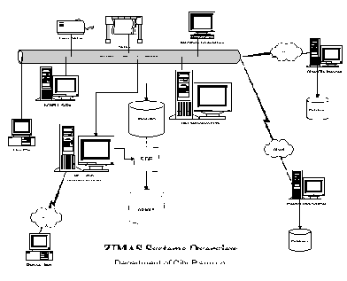
Figure 1. ZIMAS Overview
ZIMAS Pilot Development
It was determined early in the pilot that ZIMAS would be developed in a client/server environment, and that the operating system would be Windows NT. PowerSoft’s PowerBuilder was chosen because of its DataWindow capability, customization capability, ease-of-connectivity to multiple databases, wide acceptance, and broad-based support. Esri’s MapObjects was selected because of its adaptability to DCP’s ArcInfo environment and its object-oriented capability that provides an OLE linkage to third party products like Visual Basic, PowerBuilder, Delphi, and others. This object-oriented technology is not available in ArcView.
Hardware and Software
In the ZIMAS design phase, it was well established that data would be collected, stored, queried and displayed at the parcel level. Maps at various scales would include planning and zoning information on a Windows platform. The ZIMAS application was developed on a Hewlett-Packard Vectra XM4 5/166 with 128 megabytes of Random Access Memory, four gigabytes of hard disk, and operating on Windows NT 4.0. Zoning and planning-related test data coverages were downloaded from the IBM RISC/6000 file server using Fast Ethernet, 10 megabit per second, and TCP/IP protocol. The applications prototype used MapObjects custom controls, which are only supported on 32-bit operating systems, such as Windows 95 or Windows NT.
Prototype Design
An applications consultant was also involved with the development of ZIMAS. Rapid Objects, Inc., although not expert in GIS, was very familiar PowerBuilder, Windows NT, and understood the integration of various systems components. The Team investigated Environment Science Research Institute’s (Esri) ArcView and Avenue as a possible development tools, but decided that they did not provide the ease-of-use that would be required by ordinary citizens at a public counter. One of the objects of the pilot was to minimize the use of drop-down menus, create a button-oriented format, and maintain a point-and-click convention.
ZIMAS is a blend of a Single Document Interface and Multiple Document Interface (MDI) application. The prototype uses global variables to control the opening of new windows while multiple windows are already opened. MDI user interface is typically designed for more advanced users, and as a consequence, later applications testing was done only for the Single Document Interface.
The prototype uses a number of global variables to share data among the application objects. This allows the application to avoid repetitive creation, connection to, disconnection from, and destruction of MapObjects OLE objects. Additionally, a number of MapObjects constants are defined as global variables to make it easier to use more readable assignments of constants to object properties.
A customized Graphic User Interface (GUI) provides self-explanatory screens that public counter customers can readily understand. Displayed below is the main menu that the customer views.
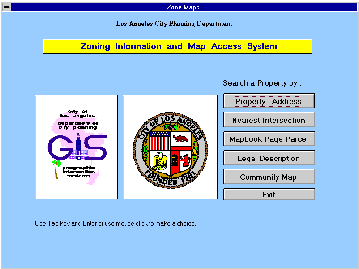
Figure 2. ZIMAS Main Menu
The ZIMAS Main Menu consists of five access buttons:
. Property Address
. Nearest Intersection
. Book_Page_Parcel
. Legal Description
. Map Access
Windows-Oriented Application
Windows are one of the most important user interface objects in PowerBuilder. Each main window represents one of the screens that the user will interact with to control the application. Most screens rely upon a PowerBuilder DataWindow object to connect to the database and perform the desired queries. Searches are performed by PowerBuilder’s QueryMode property of the DataWindow object. This property provides a means to do a "query by example" with minimal coding. The windows that are associated with five search buttons on the main menu are listed below.
The w_map window contains the default set of buttons to perform the common manipulations of Esri map custom controls. The layout and the properties of these buttons can be overridden, as desired, by the descendants, listed below.
w_map_lacity
The w_map_lacity window, a descendant of w_map, displays a map of the City of Los Angeles and a list box containing the communities within the city. The map and list box work in conjunction with each other to allow the user to select a community. When the user moves the mouse over a community and clicks the mouse button, the name of the community is highlighted in the list box. If a community is selected in the list box, the corresponding community is highlighted on the map. Figure 3 displays a citywide map of Los Angeles with boundaries of the 36 Community Planning Areas and a list box of the 36 Community Planning Area names.
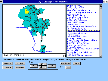
Figure 3. ZIMAS City of L.A.. Window
w_map_comm
This window, a descendant of w_map, displays the map of an entire community (or some portion of the community, if the user zooms in). The user will typically select a mapsheet to refine the search. The features that appear on the map can be controlled through the database tables.
w_map_property
The w_map property window, also a descendent of w_map, provides a map of the selected property, the area around it, and a list box with details about the property. The user can select a different property by moving the mouse over the property and clicking the mouse button. The list box with property details is updated each time a different property is selected. Interfaces with other access method will bring up this window after the user has selected a property through one of the search methods provided by the application. Figure 4 shows detailed parcel-level information about the subject property.
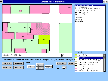
Figure 4. ZIMAS Property Window
User Objects
The user object is a combination of an Esri’s MapObjects map control and a scale readout. User objects are used in each window that contains a map. The object was contrived to allow the parallel development of the visual and database features of PowerBuilder windows while applications development was proceeding with geographic data logic design. This would allow two separate functions to be developed independently so one would not interfere with the other design.
Later in the application development process, the ZIMAS Team separated the user object into two controls to improve the performance. One was the object that managed the graphic drawing, the other was the object that controlled the non-graphic information display.
Future Development
As the pilot development is expanded, additional GIS information and planning-related information have merged into the project scope. Environmental and socio-economic data, planning case and permit information and data analysis tools, all of which are important in the planning process, will be placed and retrieved from a higher menu selection. As shown on Figure 5, ZIMAS will be one of six buttons available to the user.
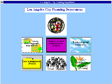
Figure 5. City Planning Information Window
The ZIMAS prototype was developed to test new technologies with limited data. Some of the prototype code was developed to test new concepts quickly or written to work around defects in early releases of software products. Additionally, the structure of the code was designed in an iterative manner, using the rapid application development methodology, until the list of desired features became more refined. The code, therefore, may not necessarily be the most efficient when deployed in a production environment. Before a full service systems is developed, the set of global variables in the application should be examined and reduced where possible.
The prototype will be expanded to provide an interactive access to other Planning information, such as case and permit information, demographics, socio-economic data, environmental information, hearing notices, City Council meeting minutes, planning analysis, and other information. Any future system must be easily scalable, expandable and upgradable.
Internet
ZIMAS must also consider the large number of personal computers running on Windows 3.11. For these machines, a separate user interface may have to be developed that will run on a web browser such as Netscape’s Navigator or Microsoft’s Internet Explorer. Changes and re-engineering of the application may be required to support browser-based user interfaces. In addition to the tool set utilized in the pilot program, Esri’s Internet Map Server for MapObjects will be the link between the browser and the server. Initially, HTML will be used for designing the web pages, and, in for future development, Java scripts will be investigated. DCP intends to test and install the application on the City’s Intranet first, and later adapt the technology to the Internet for public access.
Database Design
The ZIMAS Team developed database tables and indices as needed for rapid development. A more thorough data entity analysis is required to describe the database objects and a database design to improve data access must be undertaken.
Currently, the Department of City Planning has collected geographic data by mapsheets that are stored in ArcInfo. This type of GIS data structure does not lend itself to applications such as edge-matching with adjacent maps where seamless appearance is important. Esri’s Spatial Database Engine (SDE) may provide an enterprise-wide repository of spatial data and attributes within a single Relational Database Management System (RDBMS), such as Oracle, Sybase or Informix. SDE client/server architecture and built-in spatial analysis and query tools may allow efficient information access, data management and GIS data distribution throughout a network.
A citywide ZMA Program will form the basis of future strategic improvements to the City's land development procedures by improving case application processing, and enabling easier access to planning data by the public. DCP has submitted a budget request for Fiscal Year 1997-98 to fund three aspects of a ZMA Program. GIS zoning data conversion will represent the largest portion of the budget, while a GIS zoning database design and implementation, and an improved ZIMAS front-end will consume the balance of the budget.