Martin Meggs
ABSTRACT:
Agenda 21 recognises the crucial role that geographical information systems have to play in promoting sustainable development, particularly with regard to small islands. Bermuda has a long history of environmental management, with Acts designed to safeguard both flora and fauna dating back to the early 17th Century.
Bermuda has experienced considerable development pressures in recent years which threaten the Island's attractive and unique environment. The Bermuda Government has recently completed a pilot project which explored how GIS could be used to promote sustainable development and monitor environmental change.
This paper outlines these issues, from the perspective of the Department of Planning, and examines the use of ArcInfo and ArcView.
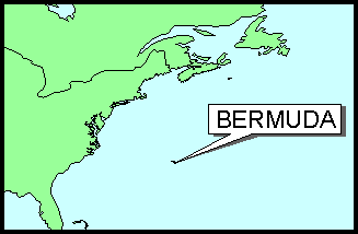
Bermuda is an archipelago of some 150 islands arranged in a narrow chain resembling a fish hook, enclosing extensive inshore waters, approximately 30 kilometres (19 miles) long and three kilometres (two miles) wide at its broadest point. They are the worlds northernmost coral islands, located in the Western Atlantic some 900 kilometres (560 miles) east of Cape Hatteras, North Carolina.
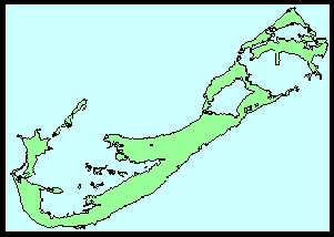
Bermuda's topography of rolling hills reaches 78 metres (256 feet) at the highest point above sea level. No freshwater rivers or streams exist, a result of the Island's small size and the extremely porous nature of the limestone rock. There is however an abundance of subtropical wetland and marine environments with brackish ponds and marshes in addition to the large shallow Bermuda platform, which is marked by the outer reefs enclosing an area of some 775 square kilometres (300 square miles). Many of these environments are of scenic, recreational and economic as well as ecological importance, but they have been subject to human disruption with the reclamation of marshland for agriculture and garbage disposal and the destruction of mangroves through cutting and dredging.
Much of Bermuda's early reputation as the "Isle of Devils" was due to the nearly impenetrable reefs. Shakespeare's The Tempest is said to have been inspired by the shipwreck of Sir George Somers on Bermuda in 1609. The reefs are one of the Island's most fragile environments and large-scale reef kill occurred during the creation of the Kindley Field Air Force Base (later the U.S. Naval Air Station and now the Bermuda International Airport) during World War II.
Today, with a population of some 58,460 ( a density of over 1100 persons per square kilometre, 3160 per square mile), the Island boasts a standard of living exceeded by very few countries in the world. With this however comes higher aspirations and expectations. Bermuda's economy relies on tourism (576,000 tourists in 1996) and international business with more than 8,600 international companies registered. The development requirements of both industries can however, threaten the very environment which makes Bermuda attractive to tourist and international entrepreneur.
The 1992 Rio Conference on Environment and Development recognised the particular problems of small island communities. They carry a high share of global bio-diversity with unique species of flora and fauna - Bermuda has a number of endemic species including the Bermuda Cedar (Juniperus Bermudiana), Palmetto Palm (Sabal Bermudana) and the Bermuda Petrel or Cahow (Pterodroma Cahow) - while facing all the environmental problems and challenges of the coastal zone concentrated into a limited land area.
Bermuda has a long tradition of environmental management. Between 1612 and 1684, when Bermuda was administered by the Bermuda Company, a number of Acts and Proclamations were passed . The Company was chartered to exploit the resources of the island and the impact of the settlers was quickly felt by the island's fragile ecosystem; an impact which was partly responsible for the eventual collapse of the Company.
In 1616, only 7 years after the first settlement of the island, Governor Daniel Tucker issued a proclamation:
'...against the spoyle and havocke of the cahow and other birds.'
In 1620, in what is perhaps the earliest piece of conservation legislation, the Bermuda Assembly passed an Act:
'...against the taking of over young tortoises' (sea turtles)
Even the abundant Bermuda cedar and palmetto forests were protected by Acts against the 'exporting of cedar' (1659), and 'destroying palmetto trees' (1662).
More recent legislation has attempted to control the built environment and the growth in motor traffic. Since 1911 the Advertisement Regulations Act has controlled the size, type and location of commercial advertising. Automobiles were only generally introduced in 1946 when the House of Assembly rescinded a ban on motor vehicles.
In recent years Bermuda has experienced unprecedented rates of growth and development. Between 1970 and 1990 the resident population increased by 16%, employment grew 34% and there was a 44% increase in the housing stock. Despite a limit of one automobile per household, the number of private automobiles has steadily grown with some 21,088 registered private automobiles in 1995. With only 240 kilometres (150 miles) of public roads, and an equal amount of private roadway, traffic congestion is becoming an acute problem. The early 1990s also saw a serious downturn in the Island's tourism industry, leading to calls for a reappraisal of the type of product provided.
The Bermuda Plan 1992 recognised that it was impossible to accommodate these high levels of growth without environmental change. While such growth had brought about an enviable standard of living, it threatens the very qualities and character on which Bermuda's success is founded.
The Plan embraced the concept of sustainable development, with a move away from a development-orientated plan to one promoting environmental management. A key part of this strategy lay in the development of a comprehensive information system to monitor the effectiveness of the Plan during its implementation. A number of systems, developed in-house, were already in place. The Applications Management and Information System (AMIS) tracks planning applications, developments approved, projects under construction and completed.
A geographic information system (GIS) was regarded as being crucial to the development of any comprehensive monitoring process. Agenda 21, Annex II of the report of the Rio Conference recognised the role that GIS had to play in promoting sustainable development, particularly with regard to small islands.
Paragraph 17.131 states:
"Additional information on the geographic, environmental, cultural and socio-economic characteristics of islands should be compiled and assessed to assist in the planning process. Existing island databases should be expanded and geographic information systems developed to suit the special characteristics of islands."
Bermuda's GIS project predates Agenda 21 but has been given new emphasis by it and its relevance to sustainable development. The project is a corporate venture with key players from the main land-related Government Departments - Land Valuation, Planning and Works and Engineering (W&E) - together with technical support from the Computer Systems and Services Department. The Bermuda GIS Pilot Project emerged out of the realization by a number of Departments that they needed to investigate the potential of GIS in a coherent and coordinated way, to ensure that efforts were not duplicated. It was believed that the coordination of initiatives could form an appropriate basis for a bottom-up approach to GIS development in Bermuda. Early attempts at imposing a top-down solution to information system problems had not always worked with individual Departments lacking a sense of ownership of the system.
Knowledge concerning the capabilities of GIS was minimal in Bermuda, so it was decided to proceed with a pilot project to explore GIS and promote a greater awareness of GIS throughout the island.
The Pilot Project was established to investigate GIS technology, both hardware and software, to develop prototype applications and to establish the requirements for an island-wide GIS. Environmental Systems Research Institute, Inc.'s (Esri) ArcInfo was chosen as the GIS software; in addition ArcView 2.1 was also tested.
Bermuda is almost an ideal location for establishing a GIS. As a small island, it is a separate self-contained unit which can be handled comfortably by a modest computer system. It has accurate and up-to-date 1:2500 mapping which reduces the initial costs of digital base-map preparation. Data collection, the creation of digital map sets and associated data tables accounts for most of the cost of setting up a GIS. In Bermuda, this is a relatively manageable task which can be completed in a fraction of the time required in most jurisdictions.
Both Government and private-sector activities could be incorporated into an island-wide GIS. Ultimately, almost every Bermuda resident and visitor would experience some benefit from more efficient land management, environmental planning and utilities planning, as well as improved transportation, postal, census and emergency services.
A number of prototype applications have been developed in the Departments of Land Valuation, Planning and Marine and Ports. These have enabled the testing of GIS functionality, the development of appropriate data conversion methodologies, both for digital mapping and conventional databases, and have enabled staff to become familiar with GIS and GIS concepts. The level of awareness about GIS and its capabilities is now much higher within the core Departments as well as within the Bermuda Government as a whole.
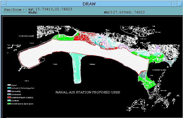
During the pilot phase the effectiveness of GIS soon became apparent when a decision by the United States Government to close its Naval Air Station in Bermuda meant that some 10% of Bermuda's land returned to Government stewardship in September 1995. On a small island such as Bermuda this is a significant area requiring careful planning.
A Military Bases Transition Office (MBTO) was established in 1994 to oversee the handover of the former military bases. As part of managing the transition process, the MBTO needed to prepare a strategic plan to determine the future development of these areas. A requirement of this plan preparation process was to have a set of 1:2500 scale topographic maps in digital format which could be used by the selected team of planning consultants in their design work. The task of acquiring the digital data was delegated to the Department of Planning, where the GIS pilot was centered. It was decided therefore to digitize the 16 relevant 1:2500 map sheets into ArcInfo format. Using ArcInfo it would be possible to provide the digital data in a number of formats to the eventual consultants.
The timeframe within which the data was required prevented the preparation of a detailed digitising specification. The design of the feature inventory evolved over the course of the digitising project through communications between the Department of Planning and the chosen contractor, Westinghouse Landmark GIS, Inc. (now ASI Landmark). The final design allowed for 14 feature layers, or ArcInfo coverages, with each layer containing a number of individual feature codes. These layers were as follows:
The contract called for the digital map to resemble as closely as possible the original paper maps; there was, therefore, a considerable amount of time spent by the contractor on the creation of symbolsets in ArcInfo. These are required to produce annotation, lines, markers (symbols) and shading on the digitally produced maps. It was not always possible to exactly match the original shading style or line type but a close approximation was attempted. This work revealed the flexibility which is possible with a digital product and the opportunities for enhancing output. The data was supplied as ArcInfo Export format files which could be loaded into ArcInfo for immediate use. The data was then provided to consultants and incorporated into a broad land-use plan. It also provided the Bermuda Government with a tool for developing a facilities management application for the airport infrastructure, using CAD data formerly held by the U.S. Navy.
During the course of the pilot project it became apparent that with the development of Esri's other GIS products such as ArcView and MapObjects, an alternative, but complementary development strategy to that originally envisaged, presented itself for Bermuda. Although ArcInfo is a very powerful GIS toolbox, it was felt that the more occasional user would find it somewhat daunting. For that reason ArcInfo is to be reserved for the 'power users' who require its sophistication; systems development will instead focus on ArcView and MapObjects. Indeed, MapObjects has given us the potential to re-engineer our existing systems to incorporate GIS functionality without the user necessarily being aware that they are using a GIS tool.
Within the Planning Department a prototype application was developed using ArcView and Avenue. Using topographic map data from ArcInfo coverages, a user can select the area of interest via a hot link tool. They can then further refine their area of search using a customized zoom in button. The selected area is displayed at a predefined scale together with a second view denoting the area of search on a smaller scale.
Once a property is selected, information and any linked application data about that property is displayed in a table format. A single button allows a preformatted layout, containing relevant data about the property, to be printed.
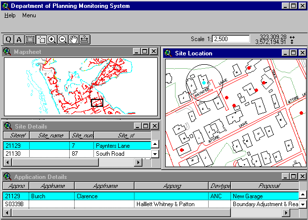
The Department benefited from having its AMIS system written in Dbase IV, and therefore ArcView could directly access these files. Similar results have also been achieved using SQL to query a Microsoft Access database.
The ability to identify a property graphically from a map is a key feature of any GIS; in Bermuda, where all roads were unnamed prior to the late 1960's and nameplates on private roads only became common in the 1980's, it is even more useful. Most people are able to locate a property on a map even if they may not know the correct street address.
Using the experience gained from the pilot project, the Ministry of Works and Engineering is in the process of acquiring a digitised topographic map base for Bermuda at 1:2500 scale; this involves 74 2000m x 1000m sheets. In addition to the maps themselves a number of other key files will be produced to enhance the digital product; these include a property gazetteer, road centrelines and Digital Elevation Model (DEM). Once these base datasets have been completed planning layers showing environmental constraints and development opportunities will be added. The constraints layer will present the Conservation Plan illustrating the system of protected open spaces and the location and extent of all important natural features. The opportunities layer will show the Development Zoning which indicates the type and intensity of development to be permitted for a variety of uses.
The existing zoning maps produced for the 1992 Plan are all hand drawn and took many hours of painfully detailed work to produce and check. The creation of a digital database of this information will make the next Plan quicker and easier to produce, thereby allowing more time to be given to other aspects of the Plan.
Another key role of the GIS will be to analyse the zoning composition of new application sites, currently a time consuming clerical task requiring consultation of one or more 1:2500 map sheets. The GIS will also undertake a planning constraints analysis, triggering appropriate consultee letters or e-mail notification as required. Longer term monitoring of conservation areas will enable planners to ensure that the Plan is meeting its aim of promoting sustainable development.
The GIS is currently being developed on a small network of SUN UNIX workstations which run ArcInfo, and a number of personal computers running ArcView 3.0 under Windows 95. It is planned that such PCs running Windows 95 or Windows NT Workstation will be the predominant means of access to the GIS, allowing clients to use the GIS through a familiar Windows environment. Currently the workstations and PCs communicate using TCP/IP and SAMBA server software; it is envisaged that over the next year or so these systems will all migrate to a Windows NT platform thereby providing a consistent approach and reducing system administration overheads.
The need to update the Department's AMIS system to a 'windows' graphical interface has also opened up the possibility of imbedding GIS functionality into our day-to-day information systems, by using MapObjects in combination with SQL Server and Visual Basic. The Department is currently in the process of drawing up a specification for such a system.
The Internet also offers a number of scenarios. Computer literacy is fairly high in Bermuda with many homes having a PC and increasing numbers gaining access to the Internet. Already a number of web sites offer tourist and business information about the island. The Department of Planning is keen to develop a web presence which would not only provide information about the Department and its activities, but could also offer a 'virtual planner' service whereby clients could be stepped through an application on a particular property. They could be advised of possible zoning conflicts through on-screen map overlays, and given other relevant information.
In conclusion, GIS will enable the Department of Planning to monitor much more closely what is happening on the 53 km2 that are Bermuda, enhancing its ability to protect Bermuda's environment and to develop a sound ecotourism industry on which many believe its future can be built. Bermuda's motto 'Quo Fata Ferunt' broadly translates as 'Where fate would take us', a reflection on the shipwreck in 1609 which led to the original colonisation of the island. Today, Bermuda can no longer rely on fate to guide her; perhaps the information provided by GIS can help to steer Bermuda into a more sustainable course for the 21st Century.
Martin Meggs
Planner (Information Systems)
Department of Planning
Government
Administration Building
30 Parliament Street
Hamilton HM12
BERMUDA
Telephone:(441)297-7778
Fax:(441)295-4100
Email:
mmeggs@ibl.bm