Using GIS for Meeting the Requirements of the National Environmental Policy
Act (NEPA) |
|
Stephen E. Gould, John M. Mores, and Kevin S. Schroeder |
|
To be presented at the Seventeenth Annual Esri User Conference San
Diego, California, USA · July 8-11, 1997 |
Abstract
 The importance of spatially-related data is inherent
to the National Environmental Policy Act (NEPA)-required Environmental Impact
Statement (EIS). As such, the EIS provides significant opportunities to apply
Geographical Information System (GIS) analysis to assist in completing the EIS.
GIS databases are essentially spatially referenced databases that allow one to
control the distribution of form over space and through time. Consequentially,
the large datasets, spatial orientation requirements, and frequent changes to
large EIS undertakings, such as ones required for major highway improvement
projects, makes most of the 25 features analyzed in an EIS ideal for GIS
analysis. A 51-mile proposed highway improvement project in southeastern West
Virginia is discussed to demonstrate the uses, benefits, and limitations of GIS
in addressing EIS requirements. Particular attention is given to the methods
used to complete the GIS analysis for the EIS land use analysis and the
development of two GIS-based archaeological predictive models.
The importance of spatially-related data is inherent
to the National Environmental Policy Act (NEPA)-required Environmental Impact
Statement (EIS). As such, the EIS provides significant opportunities to apply
Geographical Information System (GIS) analysis to assist in completing the EIS.
GIS databases are essentially spatially referenced databases that allow one to
control the distribution of form over space and through time. Consequentially,
the large datasets, spatial orientation requirements, and frequent changes to
large EIS undertakings, such as ones required for major highway improvement
projects, makes most of the 25 features analyzed in an EIS ideal for GIS
analysis. A 51-mile proposed highway improvement project in southeastern West
Virginia is discussed to demonstrate the uses, benefits, and limitations of GIS
in addressing EIS requirements. Particular attention is given to the methods
used to complete the GIS analysis for the EIS land use analysis and the
development of two GIS-based archaeological predictive models.
Introduction
NEPA, EIS and GIS
NEPA (1969) was established by the federal government
to ensure that all agencies of the federal government prepare an EIS when they
undertake major federal actions, or fund or permit lower government actions
significantly affecting the environment.
The EIS is used: (1) to ensure that federal agencies
carefully consider significant environmental impacts arising from projects under
agency jurisdiction; (2) to establish a procedure by which the public is given
an opportunity for meaningful participation in the agency's consideration of the
proposed action; and (3) to provide a record for legal challenges to the
project. The EIS is designed to be a detailed and quantitative investigation
which rigorously documents the findings of potential environmental impact of the
proposed project and also addresses the public concerns.
The inherent spatial requirements of an EIS (i.e., the
need to assess the impact of a proposed project on the environment) provides
significant opportunities to apply GIS analysis for completing the EIS project.
GIS analysis can greatly enhance the evaluation of EIS-required items. A case
study of the use of GIS analysis for land use and archaeological resource (both
prehistoric and historic) analyses is presented along with a discussion of the
benefits and limitations of the GIS process.
Addressing land use and archaeological resources
requires the quantification of the land to be affected by the project.
Specifically, land use analysis requires estimating the acreage of various types
of land use (e.g., agricultural and urban land) to be impacted. Archaeological
resource analysis requires estimating the amount of land of varying potential
(i.e., high-probability, moderate-probability, and low-probability) for the
occurrence of significant prehistoric and historic archaeological sites.
Project Background
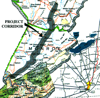
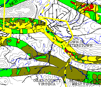
Project Area. The project discussed is a
51-mile section of a two-lane rural highway located in southeastern West
Virginia (Figure 1). The study area includes some of the most beautiful and
historic resources in West Virginia. It includes White Sulfur Springs, a resort
built in 1834 and frequented by presidents and congressman. The study corridor
follows the ancient Seneca Indian Trail, used by the Iroquois to control their
large area of influence. This natural transportation corridor was also a
crossroads for Union and Confederate troops during the Civil War. The result is
that the area's resources are often beautiful, stately, and potentially of major
historical significance.
 |
|
Figure 1.Project Location |
Press here for
additional figure information.
Project Scope and Purpose. The project's goal
was to improve the present two-lane highway to a needed four-lane highway while
not substantially impacting the environmental resources in, and adjacent to, the
project area.
GIS Perspective. A team of five consulting
groups produced over 1.2 gigabytes of computerized data as part of the initial
phase of this investigation. During this initial phase of the project, it was
determined that an EIS of this magnitude would most satisfactorily (with respect
to time and money) be addressed using a GIS, as compared to analyzing hardcopy
maps with planimeters, and other conventional methods of analysis.
Consequently, GIS software (ARCINFO and ARCVIEW) was brought into the project to
organize, manipulate, analyze, and present these data to meet the rigorous
requirements of the EIS evaluation.
Project Analysis
The project area and preliminary design improvements
to the highway were provided to the project team to assess which improvements
should be recommended to upgrade the highway. The first step was to determine
the geographic and environmental data that would be needed to address the
requirements of the EIS, and how to gather and assemble the data for processing.
The next step was to input, manipulate, analyze, and display the data to meet
the requirements of the project. Graphic display of the project was difficult,
since the project area was oriented north to south, and measured approximately
51 miles long and only one-mile wide. This type of linear project could not
easily be displayed for report size graphics. The project team decided to
divide the project into fourths and orient from east to west for report
presentation. Therefore, there would be four segments of approximately 13 miles
each. This was achieved by CLIPping four equal lengths of the project area and
TRANSFORMing them into an east - west projection. Example layouts used as they
apply to the land use coverage are shown on Figures 2a and 2b. (Please note:
words such as CLIPping and TRANSFORMing identify a specific ARCINFO command and
an action performed with these data.)
Land Use Analysis
The objective of the analysis was to calculate the
area of each type of land use that would be impacted by the highway
improvements. The analysis employed the review of aerial photographs and the
copying of various land uses observed on photographs to the approximately 200
preliminary design maps (developed at a scale of one-inch equals 200 feet) for
the highway improvement project. Land use data transferred to these maps were
checked during field investigations to verify the accuracy of the aerial
photograph interpretations.
After checking the data, the information was prepared
for scanning into a digital format. To initiate this process, a mylar overlay,
approximately two feet by three feet, was placed on top of each design map and
the land use shapes originally transferred to the design map were copied onto
the mylar sheet. Each land use shape (or polygon) was given an identification
number indicating the land use type it represented. Approximately 200 mylar
sheets were scanned into computer images at a maximum rate, determined by the
limitations of the scanning equipment, of 40 sheets per day.
The scanned images were converted into four GIS land
use coverages, one coverage for each quarter of the project area. Table 1,
Feature Attribute Data, was created for each type of land use identified on the
mylar sheets. This table was joined to the land use coverages using the
JOINITEM command with the land use identification number being the common "joining
item." Quality control was conducted by overlaying and comparing the
original mylar sheets with the hardcopy maps of land use coverages developed
from the scanned data.
Table 1. Feature Attribute Data1
Land Use Identification Number
|
Type
|
Code
|
|
101
|
Urban
|
1
|
|
102
|
Agricultural
|
4
|
1 This table is an
example of the feature attribute data. Additional land uses, not shown on this
table, were required by the project.
The next step of the analysis was to CLIP the land use
coverage with the proposed highway modifications. The CLIPped coverage was then
imported into ARCVIEW for tabular analysis of land use acreage to be
potentially impacted. From ARCVIEW, the land use table was EXPORTed into a
spreadsheet computer program for calculation of total potential impact acreage
for each land use type. This calculation was conducted by sorting the table by
land use type, and quantifying the potential impacted areas for each land use.
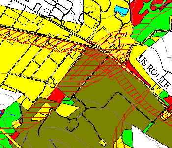
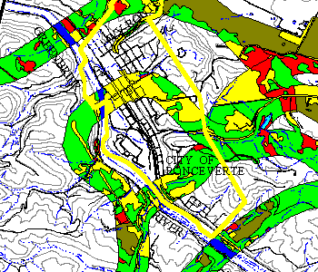
Figures 2a and 2b illustrate the land use within the
project area, and Figure 3 is presented as a close-up of part of the project
area to display the detail of the GIS analysis.
 |
|
Figure 3.Detailed Land Use Impact Analysis |
Press here for
additional figure information.
GIS Benefits. Benefits attained from using a GIS analysis as
compared to traditional methods of analysis included:
- increased work quality;
- increased work efficiency and labor-time reduction;
- increased flexibility of analysis for changes to highway design; and
- cost savings.
If the traditional method of analysis was followed for
quantifying land use, it would have required the planimetering of approximately
200 hardcopy maps at a scale of one-inch equals 200 feet for the entire project
area to delineate land use. The individual areas of each land use (or land use
polygons) would then have needed to have been summed and this information would
have required a manual quality control review. It is estimated that such a
process would have required approximately four times the man-hours.
By using the GIS, and scanning hardcopy maps into the
GIS database, significant portions of the manual labor were removed from the
data capturing process, and the quality of the final product was increased as
less handling of data was required to obtain the final desired information.
Equally important was the fact that the data could be easily analyzed and the
database could efficiently accommodate changes in the analysis criteria and
highway modification design change.
GIS Limitations. A significant amount of time
was required to establish communication among the various parties performing the
EIS to establish proper GIS data format and required quality control. The
rigorous format required by the GIS, although insuring a high-quality analysis,
also provided little forgiveness in formatting the information. Establishing
ARCINFO polygon topology, that is, establishing data in the proper format for
spatial analysis, did require significant time, and had to be fully completed
prior to conducting the analyses. Establishing the topology consisted of
BUILDing and CLEANing the coverages by closing the land use polygons and
assuring each polygon had only one label point and a unique user identification
number. Also, converting the Intergraph files used by state highway departments
to ARCINFO-compatible files was expensive and increased the size of the data
files by several multitudes.
Archaeological Resources Analysis
Archaeological Predictive Models. The nature
of historic and prehistoric archaeological analysis requires predictive modeling
to identify areas likely to contain important archaeological sites. In
conjunction with the background research, the predictive models for
archaeological site locations were developed which identify areas of
high-probability, moderate-probability, and low-probability for the locations of
both prehistoric and historical archaeological sites. High-probability areas
were those areas where archaeological sites are most likely to be encountered.
Moderate-probability areas were defined as sensitive locations where
archaeological sites could occur. Low-probability areas were defined as
unlikely locations for the presence of archaeological sites.
Prehistoric Archaeological Predictive Model.
The development of the predictive model for prehistoric site locations in the
project area involved a review of the results of previous archaeological studies
in the project vicinity, informant interviews, analysis of locational data on
previously-recorded prehistoric sites in the project vicinity, and comparison of
these data to the environmental characteristics of the project area.
Analysis of data on recorded sites in the project
vicinity were combined with information from previous research and informant
interviews to identify trends in prehistoric site locations. These trends in
site location were then used to predict the occurrence of unrecorded prehistoric
sites in the affected environment of the project, and establish the parameters
for the predictive model. Specific types of data collected included
physiographic and topographic setting; associated landforms, drainage, and
soils; and the ages of the specific prehistoric components identified.
The predictive model criteria, formulated from trends
in prehistoric site locations and used to determine areas of high-probability,
moderate-probability, and low-probability of identifying prehistoric
archaeological sites, was based on:
- slopes less than 20 percent;
- specific soil types; and
- distances to perennial surface waters.
ARCTIN was used to identify land with slopes less than
20 percent. This slope analysis was further constrained by selecting specific
soil types within the land containing 20 percent slopes. To establish the soil
coverage, data from 17 maps from the Soil Conservation Service (SCS) were
scanned into digital format following the procedure used to establish the land
use coverage (previously discussed). The digitally-formatted data were then
reviewed, and specific soil types were identified for the model. Constraining
the slopes was accomplished by using the RESELECT command in ARC, allowing for
the extraction of only the soil type attributes that met the established soil
criteria. Only the common land that met the model's slope and soil criteria
were combined using the INTERSECT command to produce a single coverage. Once
these areas were identified, the distances from streams and rivers were used to
determine "high", "moderate", and "low"
probability areas. Specifically, areas were BUFFERed such that 0 to 500 feet
from surface water were considered high-probability, while areas 500 to 1,000
feet from surface water were considered moderate-probability, and areas greater
than 1,000 feet from surface water were considered low-probability. The buffer
polygons (i.e., probability areas) were INTERSECTed with the slope/soil criteria
coverage to delineate the three probability areas for the project area. The
three probability delineations were maintained as separate to allow efficient
modification to the model's criteria, and in order to maintain quality control.
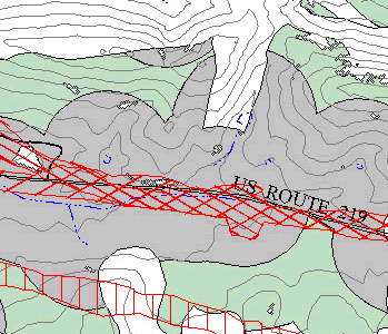
The resulting prehistoric predictive model defined
areas with high-probability, moderate-probability, and low-probability for
containing unrecorded prehistoric sites in the project site. A section of the
project's prehistoric predictive model is illustrated in Figure 4.
 |
|
Figure 4.Prehistoric Predictive Model |
Press here for
additional figure information.
Historic Archaeological Predictive Model. A
historic resources survey of the project area was conducted to identify and
evaluate the impacts to significant and potentially significant historic
resources (buildings, structures, districts, and objects).
The formulation of the predictive model of historic
site location began by gathering historic resources data collected during the
background research for this project. All historic resources, including
previously-recorded historic archaeological sites, historically mapped sites,
historic roads, and previously-recorded standing historic resources, were
documented. Newly surveyed historic resources within the project area were also
incorporated in the model-building, since they contain important locational and
potentially-important subsurface archaeological information.
The locations of historic resources were recorded on
Unites States Geological Survey (USGS) 1:24,000-scale topographic maps. These
locations were then computer scanned and digitized for incorporation into the
GIS database. This produced a historic base map depicting the location of
historic buildings, sites, structures, and courses of historic roads.
The criteria for establishing high-probability,
moderate-probability, and low-probability in the model included proximity to
historic roads, historic standing structures, and historically-mapped sites.
These criteria were depicted on the GIS using multiple overlaying queries to
identify those areas which met each of the criteria.
Buffer zones highlighting the critical features formed
the basis of the predictive model. High-probability areas were defined as those
locations within 300 feet of a mapped historic resource. These included, for
example, recorded archaeological sites and historic standing structures, and
sites appearing on historic maps of the area. Locations of moderate-probability
included areas 300 to 600 feet from the mapped historic resources, or within 300
feet of a railroad or historic road. Distances beyond the above-mentioned
buffered areas were considered low-probability.
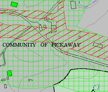
The resulting historic predictive model, a section of
which is illustrated in Figure 5, was capable of estimating the location of
unrecorded historic archaeological sites present in the project area, and their
probable location.
 |
|
Figure 5.Historic Predictive Model |
Press here for
additional figure information.
GIS Benefits. The National Historic
Preservation Act (NHPA) of 1996 requires all federal projects to undergo
identification (Phase I), evaluation (Phase II), and mitigation (Phase III) of
significant archaeological resources that are listed in, or are potentially
eligible for listing, in NRHP. During an EIS, the first step is identification
(i.e., Phase I); State Historic Preservation Officers (SHPOs) usually require
Phase I testing of all possible highway modifications to identify sites in order
to assist in selecting a preferred highway modification that has the least
impact to archaeological resources. On large projects, this labor intensive
effort of hand-digging shovel test excavations is timely and costly. If
sophisticated GIS models are used at this stage, the SHPO can get a feeling for
sensitive areas associated with a modification and select a preferred
modification without costly, large-scale excavation. The SHPO will then require
some limited testing to ground-truth the model and will only require a full
Phase I survey on the preferred modification. This reduction of work,
restricted to the preferred modification, is where both cost savings and time
savings result. Time savings is very important since NEPA has certain time
deadlines, milestones, and restrictions. Identifying sensitive areas early in
the process through GIS, rather than waiting for traditional field testing,
analysis, and reporting to be completed, is the greatest benefit to industry and
federal agencies.
Conclusions
The land use and archaeological analysis examples
demonstrate the benefits of efficiency and cost-savings which resulted from the
use of GIS analysis with the NEPA process. Project feasibility and quality were
expanded by utilizing the GIS data management and analysis tools. Limitations
of the GIS stemmed from the effort required to establish proper communication
among the various consulting groups working on the NEPA project in order to meet
the software's rigorous database format. Consequentially, the true project
benefits of using GIS software are most easily seen on large EIS projects, which
result in extensive amounts of spatial data, numerous spatial orientation
requirements, and require significant analysis flexibility. In such large
projects, the efficiency of the GIS analysis becomes apparent after the
communication protocol is established.
Acknowledgments
This paper is a result of many peoples efforts. Great
appreciation is extended to Ben L. Hark, Chief, Environmental Services Section,
and Jim Colby, Project Manager, of the West Virginia Division of Highways for
their efforts and support on behalf of this paper. Also, special thanks to
Diane B. Landers and George T. Reese for their contributions to, and review of,
this work; Gay M. Gazaway for her organization of the paper; and Thomas D.
Donovan, Jr., for his translation of the work into HTML format. Also, the
authors appreciate the technical forethought of Jonathan C. Lothrop and Benjamin
Resnick, GAI archaeologists, for their conceptual development of the
archaeological models which provided the authors with a significant opportunity
to utilize GIS. A final thanks is extended to Lucia Barbato of Esri, for her
review of the paper and guidance through the GIS paper development process.
Author Information
| Stephen E. Gould, John M. Mores, and Kevin S. Schroeder |
| GAI Consultants, Inc., 570
Beatty Road, Monroeville, PA 15146, 412-856-6400. |