The notion of teaching GIS to students in Palm Beach County originated with Til Creel, Director of the South Florida Water Management District. He recognized how much GIS was increasing the productivity of his organization and wanted to see the technology taught in the local schools. Often when a new technology is introduced in industry it can take as long as ten or fifteen years to filter down to schools -- the district saw this as a unique opportunity to start a program now and fill a growing demand for knowledgeable GIS people. Esri had already inaugurated their K-12 program and the district wanted to be involved, so the South Florida Water Management District agreed to be the corporate sponsor and the program began.
Initial faculty training was in a summer class for teachers under the direction of Monica Ramirez, the school district science specialist at the time. The class was forty hours a week for two weeks. It offered a small stipend but it wasnĺt much money considering the hours involved. I knew Monica through laser disc workshops I was doing for the county and she asked me if I wanted to take the class. It sounded like an environmental workshop to me ľ pretty far removed from the physics I normally teach ľ so I asked her if I would receive physics "in-service" points necessary to recertify my physics certificate every 5 years. She said yes, so I was one of a large group that initially signed up. In the end only nine teachers lasted the entire two weeks, and only two of us were from Jupiter, Ron Wenrich and myself.
The class was quite good, and when it finished we were all very excited about teaching GIS. Then hard reality set in. In Jupiter, the only computers in the science department were two 386 PCĺs purchased several years before with money from a fund raiser, and they were not capable of running GIS software. The only computer lab was in the business department and Iĺm not even sure their computers had hard drives. Some of us then got together on our own time to write a grant to obtain new hardware. Jane Hart (the present science specialist) helped immensely but unfortunately we didnĺt get it. We thought we might have a better chance of gaining approval if we had a full curriculum for the course, so the Department of Curriculum and Instruction recruited some of us to write one. The writing team consisted of myself, Kerry Kaysen from Santaluces High School, and Patrick Edmonson and Joe Chapa from the South Florida Water Management District. It's difficult to write a curriculum for something you have never taught but our diverse backgrounds helped us write what we felt was a pretty good product.
Implementing the course was easier said than done, with the greatest obstacle still lack of suitable computer hardware. Fortunately our school had recently been awarded some equity funds from the school district to buy equipment for two 30 station computer labs. They ordered one lab with 386's and the other with 486's. I told the principal we had to use the 486 lab for the GIS class and he agreed. When the computers finally arrived (now the summer before we started the course) I went to see them and discovered they had no hard drives. The individual at the school that ordered them decided it would be a lot cheaper to buy them without hard drives as most of the other software was accessed through the server. We required hard drives, however. The principal agreed to have them installed in all thirty computers but was not happy with the cost. He was even unhappier when I asked him to upgrade them from 4 to 8 MB of RAM. We were using ArcView 1.0 at the time and found it crashed repeatedly on 4 MB machines. One of the biggest problems in schools today is the people ordering equipment are out of touch with technology. Recently I told someone that just last summer our school district spent over a half a million dollars on new 486's. Their response was, "they still make those?"
Once the hardware was ready I still had to teach a course. The curriculum is basically a detailed outline and is certainly not enough to write lesson plans for fifty minutes of class a day, five days a week, for an entire school year. This is when the course took a technical turn, largely due to my degree in Mechanical Engineering. Anyone can teach a student to use ArcView software. It is not difficult to learn and is similar to many other software packages. The intent was to teach the students not just how to use the software, but for them to have a complete understanding of why it came about, how it works, the advantages of using it, and to be able to solve original problems with it. For me this meant endless hours of research to prepare notes and lessons on things I knew nothing about (surveying, remote sensing, etc.). It is also important for them to realize how much easier it is to perform tasks and solve problems with GIS.
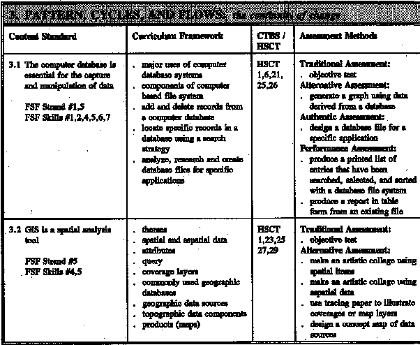
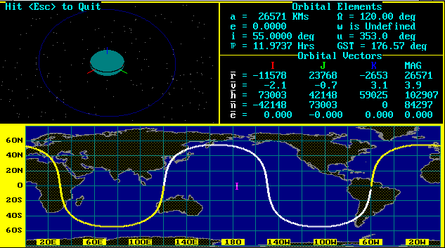
The curriculum begins with the introduction of measurement. From there we introduce grid systems, physical geography, types of map projections and models, and map scale. This leads us into the representation of data which then guides us into surveying, databases, spatial analyses, and the introduction of ArcView. I also decided it was important the students have an exposure to orbital mechanics. Unfortunately for them I became acquainted with the subject in an in-service course in Astronautics taught by several professors from the United States Air Force Academy and was able to incorporate it nicely into the curriculum. An orbit simulation program from that course proved especially valuable, turning out to be useful not just for orbital mechanics but throughout the GIS class. Using the program also helped the students become even more comfortable with computers.
To keep the course interesting I brought in guest speakers to discuss examples of real world applications. They were also able to provide some insight into technical areas that would have been futile for me to attempt to instruct. We had many speakers from our corporate sponsor, the South Florida Water Management District. Others included the Palm Beach County Department of Environmental Resources Management, United States Navy, Florida Power and Light, The Solid Waste Authority of Palm Beach County, Palm Beach County Board of County Commissioners, surveyors from Nick Miller, Inc., and Frank Conkling from the John D. And Catherine T. MacArthur Foundation. One of my favorites was Chris Kern from Navigation Technologies, who let us test drive a car with a GPS-based in-vehicle route guidance system. . The GIS class also had the opportunity to go on a field trip to a Coast Guard station, where they participated in an exercise that used GPS to aid in the rescue of a disabled boat.

The last part of the class involves student research projects. My goal is for each student to develop a unique project that applies material learned in class in an original way. This yearĺs projects included site demographics for a new solid waste authority, a statistical analysis of the circumstances surrounding shark bites, correlation of automobile accidents in Jupiter, analyzing Solid Waste Authority surveys, and connections between recycling and age, ethnicity, income, and geographic location.
In conclusion I must point out several additional difficulties. In addition to the numerous hardware obstacles, there were also problems with initially having no GPS units, finding guest speakers, and difficulty obtaining data. Perhaps the most frustrating problem was too many false promises from people with honorable intentions but who never followed them through. In the future I recommend that all hardware be made up to specifications beforehand, to have the faithful support of industry, and to have the backing of the school and school district.
I would like to acknowledge the following people who without their steady support this class would not be possible: Patrick Edmonson , Jane Hart (science specialist), Marisol Ferrer (Principal), Frank Conkling (John D. And Catherine T. MacArthur Foundation), Al Vazquez (Palm Beach County Solid Waste Authority), Art Lange (Trimble Navigation), Charlie Fitzpatrick (Esri), Frank Winters (New York State D.O.T.) and Derrick Marsh and Joyce Moody from Jupiter High School.