Michael J.
Meitner
Terry C. Daniel
Vista Scenic Beauty Estimation Modeling: A GIS Approach
Abstract:
"Natural scenic beauty" is a concept that National Forest Managers must
grapple with continuously when it comes to planning and decision making
for the future of our forests. This resource has been difficult to define
and has been the subject of over twenty years of research and development
effort. Even more complex, are the vista perspectives, where in
the viewer is typically elevated above the forest canopy and the view extends
over relatively large expanses of forest landscape. This special case requires
sophisticated techniques that take into account the levels of precision,
reliability, and validity necessary to support public land management decisions.
This paper discusses the components required for a GIS-based, "3-dimensional"
prediction model for vista scenic beauty, including, 1) determination of
significant viewpoints, 2) procedures for viewshed area specification and
analysis, 3) defining the locus of vista scenic beauty (landscape or viewpoint),
4) the definition and computational methodology of relevant georelational
landscape features, and 5) the statistical model used to generate predicted
values.
Introduction:
This paper details one component, the vista scenic beauty estimation
modeling, of the Scenic Beauty Management System, a conceptual model
for a system to support planning and management of scenic beauty on National
Forest lands. The primary role of the scenic beauty model is to translate
forest conditions, existing and projected, into precise and reliable quantitative
indices of scenic beauty. In addition, the system would provide guidelines
for and assessments of alternative management designs for achieving specified
forest scenic beauty objectives. Quantitative models and calibrated visual
representations will be provided for communicating projected forest conditions
within the multi-resource, interdisciplinary planning context, and with
concerned publics/stakeholders, (Daniel, 1996) .
The term scenic beauty is intended to capture the central aspects of what
has been labeled as visual quality, scenic quality, or visual
aesthetic value (-resource, -quality). By whatever name,
scenic beauty has long and consistently been recognized as an important
resource of the National Forests. NEPA and NFMA both require the USDA Forest
Service to incorporate "natural scenic beauty" in the management of public
lands. Moreover, any broad survey of the American public will invariably
identify scenic beauty as among the most important desires and concerns
regarding the National Forests. Thus, a system for managing scenic beauty--i.e.,
for identifying, assessing, evaluating, projecting, manipulating and monitoring
scenic beauty--must be a key component of any responsible forest planning
and management system.
While scenic beauty in general is of interest, this paper will focus on
outlining the procedure for the quantification of scenic beauty from a
vista perspective. Vista perspectives are characterized by scenic overlooks,
locations that offer relatively extensive views, as across a valley or
over a river, lake or meadow. The viewer is typically outside the canopy
of the forest and the depth of view may be measured in hundreds of meters.
Breadth of views may extend up to 360-degrees, with both landforms and
vegetation cover (especially when near the viewer) potentially restricting
the view. Some parts of the viewshed (visible area) of a vista may be substantially
below the height of the viewer and other parts may be well above the viewer.
All of these characteristics of the vista are issues that must be dealt
with if a predictive model is to be successful.
Modeling vista scenic beauty has typically focused on individual scenes,
such as the view captured by a camera with somewhere between a 35 and a
55 mm lens (Buhyoff, et al, 1982; Shafer, 1964; Shafer & Richards,
1974; Vining, et al ,1984). These types of models are typically referred
to as picture plane models. Originally, the unit of analysis for
this project was going to be the vista as a point location, but because
of the inability to validate this approach due to funding limitations we
will define the vista as limited by view angle similar to a picture. Therefore,
at any one vista point there will invariably be multiple vista viewsheds
for which the model will attempt to predict a value. Variables found important
in the picture plane models include presence and height of mountains, percentage
of the scene that is covered by forest canopy, presence and size of water
features (lakes or streams) and other relatively large scale land cover
variables. These factors are commonly determined by placing a grid over
the picture and manually counting the number of cells that contain the
attribute of interest. The effects of all of these land cover variables
differ depending upon the distance from the viewer (foreground, midground,
background) and probably upon the visual aspect (angle of intercept of
the line of sight with the main axis of the feature). Vista scenic beauty,
then, has been found to depend upon the particular features present in
the view, the pattern and inter-relationships among those features and
whether these features and patterns occur close to or distant from the
viewer (i.e., in the for-, mid- or back-ground of the scene).
Thus, vista scenic beauty is tied to the features of the landscape and
to the particular location (the viewpoint) from which that landscape is
viewed. It is impossible to refer to the "inherent" vista scenic beauty
of any given landscape feature without specific reference to the viewpoint(s)
from which it is viewed. Features that make an important positive contribution
to scenic beauty from one view point may not be visible at all from another
viewpoint, or may even have a negative effect on other views. Thus, the
"scenic beauty" of a given landscape feature is conditional upon the viewpoint(s)
from which that feature can be viewed. In some contexts it may be meaningful
to refer to the scenic beauty of a feature, based on its contributions
to the multiple viewpoints from which that feature can or might be seen,
but for the purposes of this project the I will not attempt to present
how that would be done. Suffice to say that once the viewsheds are quantified
in terms of scenic beauty, it would be relatively easy to reverse one's
thinking and predict values for objects.
These concerns offer an additional layer of complexity that differs from
the typical near-view perspective of scenic beauty from which vista modeling
draws much of it initial framework, but the underlying concepts and some
of the procedures are the same. The most successful approaches to assessing
and projecting near-view scenic beauty have been based on the public perception
or "psychophysical" model. This technology has been well tested and its
reliability, validity and utility confirmed in numerous studies (Brown
& Daniel, 1986; Buhyoff, et al , 1986; Daniel, et al, 1977; Daniel
& Schroeder, 1980; Zube, et al, 1975). Scenic Beauty Estimates are
obtained by presenting representative samples of individuals with color
slides of the forest in question and asking them to rate those slides according
to their "natural scenic beauty" on a ten point scale. These raw scores
are then transformed by statistical procedures, outside the scope of this
paper, into Scenic Beauty Estimates. Those estimates will then be related
through multivariate statistical techniques to inventoried or estimated
forest features (numbers, sizes and species of trees, volumes of downed
wood, shrubs, grasses, etc.) to create quantitative scenic beauty prediction
models. By design, these quantitative models will take as input the biological
and physical forest features. Thus, as future conditions of the forest
are projected by the biological models, estimates were provided of the
associated changes to be expected in perceived scenic beauty indices (Brown
& Daniel, 1984; Daniel & Boster, 1976).
The goal of this paper is to specify in detail the explicit structure of
a model that is capable of predicting scenic beauty values based on data
associated with a view from a particular vista location. Specifically,
to develop and test statistically-based vista scenic beauty estimation
assessment methods and prediction models for restricted (mid-range) and
panoramic views characteristic of forest landscapes in visually sensitive
areas of the Dixie National Forest. While much research has been undertaken
over the last 15 years in the development, validation and subsequent refinement
of the SBE models for the nearview perspective, very little effort
has been expended on modeling vista perspectives, and no adequate models
exist.
Opportunities for vista scenic beauty modeling efforts are greatly enhanced
by modern Geographic Information Systems technology. In particular, GIS
overlay and spatial modeling techniques can be combined with viewshed analysis
functions to develop bio-physically based models. As discussed previously,
vista scenic beauty estimations must be modeled on a viewpoint basis. Thus,
the area that is visible from a viewpoint must be made explicit and a viewshed
must be specified. Furthermore, changes in the bio-physical landscape features,
such as; topography, vegetation cover, streams and lakes that fall within
the viewshed of a designated viewpoint, along with contrasts, shapes and
patterns of these features, within the visible area (viewshed) for a given
viewpoint would serve as the independent variables in quantitative models
of vista scenic beauty. Relevant landscape features will have to be geo-spatially
referenced both in terms of their distance and azimuth relative to the
viewer (viewpoint), as well as their extents, distributions and interrelationships
within the viewshed. Because detailed three-dimensional, geographically
distributed landscape features are the logical input parameters for such
a model, a GIS platform is necessary for the adequate spatial analysis
of such complex variables.
A great deal of thought must be put into the creation of such a vista model.
Independent variables must be chosen from the multitude of possibilities
to serve as predictive parameters in our statistical model and as with
any statistical model one runs the risk of including too many variables
and ending up with a model that merely capitalizes on chance. Therefore
we must seek to discover a more parsimonious subset of the larger set of
possible variables that we hypothesis to explain our dependent variable
of interest, vista scenic beauty estimations. This paper serves
the purpose of delimiting a concrete target model through which the process
of hypothesis testing can begin and eventually by the process of model
refinement, the solidification of a final product for decision management
will emerge.
Methodology:
A stratified sample of 24 viewpoints were selected from the possible set
of 70 total viewpoints in the Dixie National Forest based primarily on
the availability of data for surrounding forest stands. A stand is loosely
defined by the Forest Service as a predominantly homogeneous, polygonal
area of vegetation. At each viewpoint a series of sixteen photographs were
taken, (image 1) in order to accurately represent a 360-degree panorama
view of the location. The photographs from the sampled vista viewpoints
were shown to representative volunteers, ratings were collected and scenic
beauty indices were computed for each view from a vista. Reliability measures
indicate a high level of agreement among observers and the viewsheds selected
represent a significant proportion of the range of scenic beauty values.
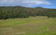 Image 1: A typical
mid-range vista
Image 1: A typical
mid-range vista
For the sake of simplicity in this preliminary analysis only one of the
16 views from each of the 24 vista points were included. The orientation
of these views were systematically selected so that the resulting viewshed
was one that contained reliable stand-level data. Each view was defined
by its point location, (X, Y, and 1.68 meter offset from the extrapolated
surface location) and orientation information, defined by two angles of
azimuth and two vertical angles. Since a 50mm lenses was used to take the
photographs the view was defined as 40 degrees of visual angle horizontally
by 27 degrees vertically, therefore a picture taken pointing due north
would be defined in the visibility command by the following parameters:
offsetA = 1.68, azimuthA = 340, azimuthB = 20, vert1 = 14, and vert2= -13.
The parameters offsetB, radius1, and radius2 were left set to their defaults.
Visibility coverages were then calculated for all the views using 30 meter
USGS DEM data concatenated with the stand height data derived by the forest
service to produce a DEM representing the canopy of the forest, as the
in lattice. "Projectcompare" was set to full so that the curvature
of the earth and atmospheric distortions were taken into account in the
calculation. The output coverages were polygonal with the frequency of
observation specified as the visible-code of the polygons. These were then
unioned with the original polygonal stand coverage in order to determine
the underlying distribution of stands that made up the viewshed. A frequency
table was then created so that the area represented by each of the stands
in the viewshed could be totaled and converted to percentages of the total
area of the viewshed.
The percentage of area was the variable used to relate the viewsheds back
to the bio-physical stand data collected by the Forest Service. Each viewshed
was then described by the weighted average of stand information visible
to the observer from the point and orientation specified. In other words,
viewshed 1, which is comprised of 30% stand A and 70% stand B, would be
represented by .3 * (# of aspen, # of spruce/fir, etc.) + .7 * ( stand
B's data). These weighted sums would then be used to calculate average
percentages of tree type represented. This allowed us to begin to build
multiple regression models to predict the scenic beauty estimates of the
commensurate viewsheds.
Conclusions:
The preliminary model, SBE = 6.025892 + 1.06729e-05 (Total Area Seen) +
-.014715 (%Spruce/Fir) + .010804 (%Aspen) - .007154 (%Dead Trees) - .012179
(%Meadow) + .070320 (# of Stands in the view), yields a R squared of .34,
which unfortunately is not significant. As the modeling effort continues
we expect to see this increase and move beyond significance, but there
are many problems that still need to be overcome. The greatest of which
is the fact that the calculation of viewshed areas is somewhat dependant
upon chance. The 30 meter resolution of the input lattice causes
the creation of sliver polygons when this layer is unioned with the polygonal
stands layer. This leads to a situation where the areas of stands
in a particular viewshed are arbitrarily specified based on the view point's
location along with the stand boundaries, in reference to the cells of
the grid used. One possible solution to this problem that we are
presently pursuing is the idea of the percentage of the stand seen as being
represented by the length of the arc of the leading edge of the stand bounded
by the viewshed. This would eliminate a great deal of measurement
error in the calculation of the percentages of represented stands, which
in turn degrades the data driving the modeling procedure, causing the relationships
to be muddied.
Ultimately, we would like to take into consideration the relative densities
of the stands, but because approximately half of our stands currently depend
on coarse GAP data it is impossible to compute average viewshed tree densities.
As more cases are introduced it will be possible to minimize the number
of viewsheds dependant on the GAP data, therefore increasing the resolution
of the underlying data. This information is also crucial to the approximation
of textural information contained in the view which may also be of importance.
The incorporation of a distance weighting scheme in order to account for
inevitable visual differences of near and far objects is also a variable
we would ulitimately like to include. As this ongoing process continues
to evolve a more significant and robust model will emerge to fullfull the
needs of Forest and other land managers so that they may better administer
the duties with which they are charged.
References
Brown, T.C., & Daniel, T.C. (1984). Modeling forest scenic beauty:
concepts and application to ponderosa pine. USDA Forest Service Research
Paper RM-256. Fort Collins, CO: Rocky Mountain Forest and Range Experiment
Station. 35p.
Brown, T.C., & Daniel, T.C. (1986). Predicting scenic beauty of forest
timber stands. Forest Science, 32, 471-487.
Buhyoff, G.J., & Wellman, J. (1980). The specification of non-linear
psychophysical function for visual landscape dimensions. Journal of
Leisure Research, 12, 257-272.
Buhyoff, G.J., Hull, R.B., Lien, J.N. & Cordell, H.K. (1986) Prediction
of scenic beauty for southern pine stands. Forest Science, 32:769-778.
Buhyoff, G.J., Wellman, J.D., & Daniel, T.C. (1982). Predicting scenic
quality for mountain pine beetle and western spruce budworm damaged forest
vistas. Forest Science, 28, 827-838.
Daniel, T.C. (1996). The scenic beauty management system: a decision support
tool for forest ecosystem management. Unpublished Manuscript.
Daniel, T.C., Anderson, L. M., Schroeder, H. W., & Wheeler, L. W.,
III. Mapping the scenic beauty of forests. Leisure Sciences, 1977,
1, 35-51.
Daniel, T.C. & Boster, R.S. (1976). Measuring landscape aesthetics:
the scenic beauty estimation method. USDA Forest Service Research Paper
RM-167. Fort Collins, CO: Rocky Mountain Forest and Range Experiment Station.
Daniel, T.C., & Schroeder, H.S. Predicting the scenic beauty of forest
landscapes: The scenic beauty estimation model. In G. Elsner & R. Smarden
(Eds.) Our National Landscape, USDA, Forest Service, 1980.
Shafer, E.L. (1964). The photo-choice method for recreation research.
USDA Forest Service Research Paper NE-29. Upper Darby, PA: Northeastern
Forest Experiment Station.
Shafer, E.L., Hamilton, J.F., & Schmidt, E.A. (1969). Natural landscape
preferences: A predictive model. Journal of Leisure Research, 1,
1-19.
Shafer, E.L., & Richards, T.A. (1974). A comparison of viewer reactions
to outdoor scenes and photographs of those scenes. USDA Forest Service
Research Paper NE-302. Upper Darby, PA: Northeastern Forest Experiment
Station.
Vining, J., Daniel, T. C., & Schroeder, H. W. Predicting scenic quality
in forested residential landscapes. Journal of Leisure Research,
1984, 16(2), 124-135.
Zube, E.H., Pitt, D.G., & Anderson, T.W. (1975). Perception and prediction
of scenic resource values of the Northeast. In E. Zube, R. Brush, &
J. Fabos (Eds.) Landscape assessment: values, perceptions, and resources,
pp. 151-167. Stroudsburg, PA: Dowden, Hutchinson, & Ross, Inc.
Michael J. Meitner
Graduate Student
Environmental Perception Laboritory
Department of Psychology
University of Arizona
Tucson, AZ 85721
E-Mail: Meitner@U.Arizona.edu
Phone: (520) 621-9263
Fax: (520) 621-9306
Terry C. Daniel
Professor of Psychology and Renewable Natural Resources
Environmental Perception Laboritory
Department of Psychology
University of Arizona
Tucson, AZ 85721
E-Mail: Danieltc@ccit.arizona.edu
Phone: (520) 621-7453
Fax: (520) 621-9306