The development of a USGS Biological Resources Division (BRD) National
Biological Information Infrastructure (NBII) at the Cooperative Resources
Studies Unit and the School of Renewable Natural Resources at the University
of Arizona (CPSU/ART) is part of a large national USGS-BRD cooperative
effort to make ecological data and related natural and cultural resources
information readily available to land managing agencies and the public.
A goal of the NBII is to establish a framework to create a distributed
"federation" of ecological information internet nodes relying
on a network of state partnerships and cooperators. Current CPSU/UA NBII
activities include: (1) the storage of primary, shared, statewide reference
Geographical Information System (GIS) ArcInfo thematic data sets such
as counties and roads, (2) the creation, modification, and storage of basic
ecological data sets required for BRD research activities and programs
such as GAP and other federal and state inventory and monitoring program
data, (3) the development of Internet software tools and protocols to facilitate
data transfer, sharing, and on-line ARCVIEW browsing, and (4) NBII coordination,
information extension, and training related activities necessary to develop
and support NBII program goals, instate cooperators, and information users.
Current efforts to distribute important ecological data to the public are
limited by a lack of coherent long-term support, adequately trained personnel,
data standards, and in some cases an adequate data distribution mechanisms
and information protocols. The exponential growth of information and distributed
computing power over the last decade has greatly increased the need to
develop an adequate infrastructure and new information paradigms to facilitate
data sharing and storage. A significant commitment to the goals of NBII
by interested parties could ensure that important ecological information
would be readily available to enhance the public decision making process
in a time-effective cost efficient manor. Fortunately, Esri GIS-based products
and programming tools have made significant progress to overcome some of
the GIS-related institutional challenges in the NBII initiative.
The Cooperative Park Resources Studies Unit at the University of Arizona (CPSU/UA) was established August 16, 1973 to provide a scientifically based multi-disciplinary approach to studies in the natural and cultural sciences. Historically, most of the CPSU/UA's research activities and programs were primarily focused on U.S. National Park Service lands. With the creation of the National Biological Survey the CPSU/UA's research mission broadened to support other federal and state agencies as well as concomitant DOI national research programs and objectives. With the October 1, 1996 DOI reorganization and transfer of the National Biological Survey CPSU/UA to the USGS Biological Resources Division (BRD) the research mission will have a great opportunity to increase interdisciplinary collaboration and synthesis at much larger spatial and temporal scales than are typical in traditional ecological studies.
Currently, the CPSU/UA conducts, coordinates, and sponsors a wide variety
of field research activities, workshops, and scientific conferences to
(1) improve natural resources management and research in National Parks,
USFWS refuges, federally protected wilderness areas, and other publicly
managed or ecologically significant landscapes, (2) provide a scientific
framework for managing natural resources, (3) maximize the usefulness of
ecologically based landscape-level information for the management and protection
of important natural and cultural resource areas and (4) promote a better
public understanding of and support for the USGS Biological Resources Division's
research programs. With the rapid development of remote sensing, global
positioning, and geographic information systems, the CPSU/UA in 1989 combined
its GIS efforts with the University
of Arizona's Advanced Resources Technology (ART) Program in the School
of Renewable Natural Resources. The goal of the Advance Resources Technology
Program is to bring together experts in various disciplines developing
advanced technologies with managers and planners to develop solutions to
agriculture, land use, and natural resource problems. Together the CPSU/UA
and ART have developed a framework of cooperative agreements and partnerships
that promote cost effective research and information sharing throughout
the desert southwest. One significant effort at the CPSU/UA and ART is
to support the development of a National Biological Information Infrastructure
(NBII) to make data and ecologically-based information more accessible
to resource managers and the public.
The goal of the NBII is to "establish a distributed 'federation' of
biological data and information sources, relying on a network of partners
and cooperators to make the data they generate and/or maintain available
to others throughout this federation, using the Internet. The basic NBII
philosophy is to encourage and facilitate biological data stewardship"
(G. Cotter, et. al. 1996). In addition, on April 11, 1994, President Clinton
signed Executive Order 12906,"Coordinating Geographic Data Acquisition
and Access: The National Spatial Data Infrastructure (NSDI) (Clinton, 1994).
The Executive order defines geospatial data as "information that
identifies the geographic location and characteristics of natural or
constructed features and boundaries on the earth. This information may be
derived from, among other things, remote sensing, mapping, and surveying
technologies." (Clinton, 1994).
"Geographical Information Systems (GIS) data, remotely sensed data,
data collected with or referenced with Global Positioning Systems (GPS)
data, aerial photography, hard copy maps, and data referenced to geographical
coordinates should be included" (Strong, 1996). In essence, Executive
Order 12906 requires federal agencies to:
1. Document all geospatial data developed after January 1995 using the
Federal Geographic
Data Committee's (FGDC) Content Standards for Digital Geospatial Metadata
(FDGC, 1994).
2. Adopt a plan for documenting geospatial data developed before January
1995. Data generated before 1995 is not required to be in FDGC format,
but is encouraged.
3. Make metadata and data accessible electronically through the National
Geospatial Data Clearinghouse, the on-line NSDI network
4. Adopt an implementation plan and establish procedures to provide access
to their geospatial data and metadata.
The FGDC Content Standards for Digital Geospatial Metadata are explained
in several publications (FGDC, 1994 and 1995) and online at the FGDC
homepage. In 1995 the CPSU/UA and ART received NBII funding to begin
to develop an NBII information node at the University of Arizona. During
this pilot project the CPSU/UA and ART have taken the first critical steps
to meet national NBII goals. For example, over the last 18 months the following
activities have been completed or initiated:
1. Completed the construction of on-line digital GIS libraries using existing
CPSU/UA-ART Arizona based GIS thematic datasets. Datasets have been created,
obtained, and distributed to and for numerous clients including the U.
S. National Park Service, U. S. Fish and Wildlife Service, Department of
Defense, USDA Agricultural Research Service, Arizona State Land Department,
and numerous regional entities who have requested or funded the expense
of acquiring ecologically related data sets. Currently, on-line GIS digital
libraries are in an ArcInfo GIS format. Imagery libraries consists of
various types of remote sensing data for the state of Arizona (mostly thematic
mapper) to isolated natural color 70mm digital images of individual parks.
All CPSU/UA-ART digital libraries are accessed via the CPSU/UA home page.
2. Are continuing to create or modify existing GIS metadata, as much as
is possible, to meet the Federal Geographic Data Committee (FGDC, 1995)
metadata standards for geospatial data. When possible, the current metadata
implementation strategy at the CPSU/UA is based upon the BRD "superset"
information standard that includes ancillary information required to interpret
the data, describe ecological results or classification systems, and clarify
biological nomenclature. ArcInfo GIS metadata are created and captured
by the use of Esri's Document.aml program tool that is distributed with
Esri's UNIX-based ArcInfo GIS software. Document.aml meets the FGDC metadata
standard. The NBII metadata standard can be accesses at http://www.nbs.gov/nbii/current.status.html.
In addition, the BRD has developed a PC-based software tool for metadata
capture and management. This software tool, called "MetaMaker"
may be downloaded from the BRD Environmental
Management Technical Center home page .
3. Have created an Internet Netscape menu driven interface so that client
agencies and other interested parties could examine data catalogs and selectively
download GIS thematic coverages by user defined areas and themes of interest.
Currently, users have two methods to view on-line spatial catalogs and
data holdings. The first method includes the ability to examine the geographical
extent and related metadata of the data by viewing gif images of GIS coverages
and text files respectively. The second method, permits users (clients
with Open-X, TCP-IP hardware) to dynamically explore the data by launching
a custom developed server ArcView interface from Netscape. ArcView permits
the user to define the information content prior to downloading by selecting
individual thematic datasets, conducting a spatial query, or by zooming
to a selected area. In either case the selected information is dynamically
extracted from the libraries and copied to the CPSU/UA-ART anonymous FTP
site for subsequent downloading.
4. Are extending or developing cooperative mechanisms and agreements to
share federal, state, and local governmental GIS thematic and ecological
data. In addition, numerous efforts are underway to share or develop regional
ecologically- base data sets from numerous private sector cooperators and
data contributors in California and Mexico.
5. Have extended participation in existing regional partnerships such as
Arizona Geographic
Information Council (created by Arizona Governor executive order) and
other institutions and associations in the region. These cooperative mechanisms
reduce the overall burden and public expense of creating and maintaining
GIS thematic databases required for effective ecological assessment activities
and coordinated regional planning efforts.
6. Have been active in developing state partnerships to collect information
necessary for the assessment of the accuracy of Arizona Gap Analysis products
including vertebrate distribution and vegetation community maps. The level
of effort (person-hours) required for adequate product assessment will
be significant because of insufficient data, non-uniform or developing
ecological classification systems or protocols, and the current status
of state-wide "standard" digital biological systematic and nomenclature
databases.
Historically, states have had simultaneous efforts, of varying duration
and quality, to inventory species and habitats. Because of insufficient
and varying levels of funding, differences between and within states have
resulted in shifting taxonomic priorities, different data collection standards,
and highly variable survey protocols and personnel expertise required to
gather consistent and comparable information. In cooperation with other
BRD national efforts the CPSU/UA has made progress in significant progress
in Arizona the ability to access, share, compare, and exchange ecological
based information. For example, current efforts include the development
and creation of a digital catalog of Arizona species locations from numerous
museum and university collections. Also efforts are underway to resolve
potential taxonomic and scientific nomenclature issues by cross- referencing
Arizona species based lists to the Interagency Taxonomic Information System
(ITIS) database. The ITIS is the first comprehensive national database
on the nomenclature and taxonomy of all U.S. plant and animal species.
ITIS information is available over
the Internet.
7. Established an Internet site to distribute information to client agencies
and the public. Until the time of this project, the CPSU/UA and ART had
no system configured and available to be committed for serving spatial
data and metadata. This NBII project provided funding to purchase additional
computer equipment to store and distribute the data and obtain graduate
student assistance to collect metadata information. The equipment purchases
were made with an emphasis on dependability and state-of-the-art server-based
technology. The additional hardware was added to the existing CPSU-ART
computer infrastructure to strengthen the information management goals
of both the Advanced Resources Technology program and the Cooperative Park
Studies Unit.
|
Equipment |
Quantity |
Purchased/Shared |
| Sun Sparc 20 UNIX Workstation -20GB HD, 64 MB RAM |
1 | purchased |
| Sun Solaris Open Window 2.4 OS | 1 | purchased |
| Sun Sparc Unix Workstations | 10 | shared |
| Sun Unix X-Terminals | 2 | shared |
| Intel-Based PC's | 25 | shared |
| HP Draftmaster II Plotter | 1 | shared |
| HP 750c Design Jet Color Plotter | 1 | purchased |
| Sparc Postscript Printers | 3 | shared |
| 8mm Exabyte Tape Drives | 3 | shared |
| HP Scanner | 1 | shared |
| Magneto-optical Storage Devices | 2 | shared |
| Calcomp Digitizing Tablets | 2 | shared |
| Disk Storage Capacity | 50GB | shared |
All computer equipment is on the network. Personal Computers run Microsoft Windows 3.31, Windows 95, or Windows NT Workstation operating systems and utilize PC-NFS to mount UNIX file systems.
We now have projects with such groups as the National Park Service,
U. S. Fish and Wildlife Service, U. S. Navy, U. S. Air Force, National
Science Foundation, Arizona Game and Fish Department, Arizona Dept. of
Environmental Quality, and Pima County. We are also cooperating in a state-wide
GIS information management program called the Arizona Geographic Information
Council. Examples of specific projects include: Arizona GAP Analysis Project
to assess how well different wildlife habitats are being protected in Arizona;
BIOTA, a cooperative effort to analyze areas for biodiversity; vegetation
mapping and GIS database development at Chiricahua, Organ Pipe Cactus.
and Tonto National Monuments; GIS and database development at Pt. Mugu
and China Lake Naval Air Weapons Stations in California; development of
GIS-based fire management applications at Saguaro National Park and Buenos
Aires National Wildlife Refuge; and the development of natural resource
monitoring database management systems at Organ Pipe Cactus and Tonto National
Monuments and Channel Islands National Park.
Additional CPSU/UA and ART National Park Service clients include but are
not limited to: Casa Grande National Monument, Coronado National Memorial,
Joshua Tree National Monument, Montezuma Castle National Monument, Petrified
Forest National Park to name a few. In addition, ART has also created several
other geographic databases in the region including those for the U. S.
Department of Agriculture (Pusch Ridge in the Catalina Mountains [USFS],
Walnut Gulch Experimental Watershed [ARS], Santa Rita Experimental Range
[USFS], San Rafael/Huachuca Mountain area [USFS]), Department of Interior/U.
S. Fish and Wildlife Service (Buenos Aires National Wildlife Refuge and
Cabeza Prieta National Wildlife Refuge), and the Department of Defense,
Barry M. Goldwater Bombing Range. These data bases are allowing us to get
to the point of developing information on resources across land management
boundaries and to begin to develop information that can be shared on a
landscape level. However, at the current rate of CPSU/UA-ART information
development we will soon exceed our capacity to "institutionalize"
the data. The amount of information that has been accumulated exceeds our
ability to store, manipulate, and distribute it efficiently. As part of
the effort to institutionalization the data CPSU/UA-ART has looked to the
Federal Geographic Data Committee (FGDC) for guidelines on Geographic Data
Standards.
The National Spatial Data Infrastructure (NSDI) is a compilation of
policies, standards, and procedures designed to foster more efficient use,
management, and production of geospatial data. The governing body of NSDI,
The Federal Geographic Data Committee (FGDC) was established through the
Office of Management and Budget (OMB) to coordinate surveying, mapping,
and spatial data activities of the federal agencies to meet the Nations
needs. The major objectives of the FGDC are to avoid duplication and minimize
costs in mapping and spatial data activities, which involves establishing
standards and providing wider access to geospatial data. The FGDC's responsibilities
also include coordination of geospatial related activities with other government,
public and private academic sectors. (http://fgdc.er.usgs.gov/fgdc.html)
One of major concerns to CPSU/UA-ART addressed by the FGDC is the development
of Metadata standards for geospatial data. These metadata
standards are discussed on line. For CPSU/UA-ART data documentation
is paramount for quality control and instrumental for determining the appropriate
use of data acquired from our digital libraries. After reviewing a variety
of data documentation tools CPSU/UA-ART decided on using ArcInfo's Document.aml.
Some of the advantages of Document.aml are: the cross platform transferability
of Metadata via its incorporation directly into the ArcInfo Export file
format, the relative ease of use for display and updating of Metadata by
the end user, and the ability for Document.aml to output metadata in a
variety of formats including HTML.
Both the Advanced Resources Technology Group (http://grotto.srnr.arizona.edu/ART/) and the USGS Cooperative Park Studies Units (CPSU/UA) (http://nbs.srnr.arizona.edu/nbs/ have established home page links to digital libraries. For example: CPSU/UA WWW GAP Analysis related data are found at http://grotto.srnr.arizona.edu/nbs/net2index.html and the ART Group, Arizona General Reference GIS data Library is located at http://grotto.srnr.arizona.edu/UAAIUG/data.html. Because of ease of use and server file related and security issues we decided to utilize an anonymous ftp service for distribution of ArcInfo export files and imagery. The primary reasons for this include: (1) user awareness of FTP and FTP server protocols, (2) to avoid external client firewall conflicts encountered when users try to download files directly to a personal computer without appropriate authorization or adequate hardware/software support and (3) to reduce cross-platform conflicts between Unix and PC environments. For example, numerous netscape clients tried to download individual coverage files and info tables without an understanding of the importance of maintaining ArcInfo workspaces and GIS file structures.
To enhance the usefullness of digital library data and promote the institutional sharing of GIS coverages several key issues were identified. To promote data exchange GIS coverages would have to be quickly located, viewed, and downloaded. To reduce network traffic and computer processing time a custom user interface would have to be developed to help the user define, limit, clip, or select the GIS data of interest. To integrate information between libraries and improve query capability semantic protocols and data classification standards would have to be developed. Consequently, we decided to break the NBII project into three distinct phases. Phase I would include the construction of prototype GIS libraries and a means to download entire ArcInfo coverages from Netscape via the WWW and FTP. Phase II would include the customization of ArcView using Avenue scripts to facilitate GIS data browsing, query, and visualization. Phase II would also permit the user to define the geographic area of interest, thereby reducing file sizes, prior to export file creation and FTP downloading. Phase III, which has just begun, will examine inter-library communication and data classification issues as well as developing new "intelligent" agents and semantic protocols to allow the non-expert user an efficient means to query non-uniform, technically complex, or disparate datasets over the www. Phase III will be the most difficult of the three phases because of the highly varied and dynamic nature of electronic libraries and the expertise required to integrate jargon and disciplines. Below is an outline of CPSU/ART phase accomplishments to date.
Phase I: Netscape, HTML, and /CGI Path:
Phase I of our implementation strategy included the creation of a HTML interface through which users could select coverages and dynamically create ArcInfo export files. In addition two prototype thematic GIS libraries were created to help examine and better delineate NBII information needs and technical requirements. The prototype GIS libraries for this project were created to resolve problems of distributing GIS data to users on a day-to-day basis and to meet the increased scientific demand for GIS-based information. As a result the prototype libraries that are active are:
In order to enable users to easily access and export coverages of interest, we created an HTML interface that included the following features: (1) A form that first gets details about the users and the coverages of interest to them (2) A list of coverages available; with the gif images, documentation about the coverages, as well as the option to export it. If the user selects the option to export the coverages, that initiates a UNIX shell script that then: (1) Takes the name of coverages, (2) Accesses it in the library, (3) Creates an export file from it, and (4) Transfers it to our anonymous public FTP site. To keep the public FTP site from getting cluttered up, we have another UNIX script that cleans up that directory every 24 hours in the middle of the night.
Phase 2: ARCVIEW Customization with Avenue Scripts:
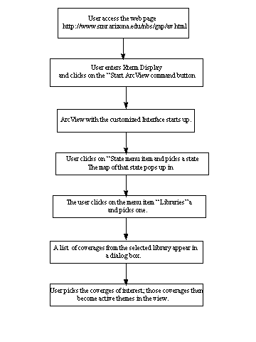
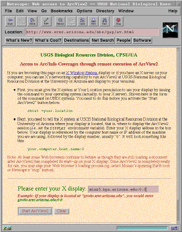
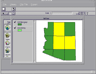
The next phase involved extending the implementation from Phase 1 to make it more user friendly. We decided to use a customized ArcView interface to help users browse our libraries and spatially subset or "cookie-cut" the relevant datasets. Figure 3, Figure 4 and Figure 5 shows the step-by-step functionality of our system.
In general, phase 2 procedural steps are: (1) A HTML form asks users for information about themselves in order to keep administrative track of the who obtained data and why. (2) A CGI script launches ArcView through a Web browser like Netscape. (3) A customized ArcView interface launches the following scripts to make the interface more user friendly: (a) A script to allow the user to select the state of interest i.e. AZ, CA, UT, NM, and CO. (b) A script that provides a dialog menu with a list of libraries and coverages that users can select from. (c) A script that brings up the appropriate grid or tile coverages that the user can select to define the spatial area of interest i.e. by county, 7.5 or 15 minute USGS quadrangle, or by a user defined grid. (d) Scripts that enable the user to point, click and drag the cursor on the active view to select parts of one or more areas that are of interest by using various combinations of grids and tiles. Coverages may be downloaded two ways:
Advantages of Our Approach:
ArcInfo coverages are being served over the Web by several sites. The
ones we have encountered have export files created beforehand and stored
on the machine, which can then be downloaded/FTPed by users. Dynamically
creating export files of coverages as and when requested by users has the
following advantages: (1) As the export files are not created beforehand,
this saves a lot of space on the system. (2) The export files are created
on the fly from coverages in our library. The primary advantage of this
is that updates to the coverages are automatically incorporated in the
export files. This eliminates the risk of serving outdated coverages or
export files to users. (3) It saves time and effort as human beings do
not have to manually create export files. (4) The customized ArcView interface
lets users browse the GIS libraries and export only those coverages that
really interest them. (5) Users can also select parts of coverages and
'cookie-cut' data of interest instead of exporting whole coverages. This
saves a lot of bandwith considering the size of each statewide coverage.
Examples of Unix Script s:
1. This UNIX script creates a shape file for use in clipping coverages
to a user defined extent.
|
2. This Unix Script creates copies of required coverages, clips them,
makes export files from them, and puts them in the public FTP directory.
|
3. The following script takes the list of active themes, creates a
shapefile from the features that the user has selected, clips the coverages
represented by the active themes, creates export files of the same, and
puts them in an FTP directory.
|
4. The following script takes a list of active themes and creates export
files for those coverages, and puts those in a public FTP directory for
the user to pick up.
|
5. This is the UNIX script to export whole coverages
|
So far, we have been successful with serving GIS data in a flexible
manner to users from a single site. However, the following points are yet
to be addressed: (1) Data does not necessarily exist at a single site,
(2) Data formats extend beyond spatially well defined GIS coverages; digital
libraries must also include satellite imagery, ground photographs, aerial
photography and videography, and a wide array of non-spatially referenced
data. (3) Users generally have higher level queries in mind. E.g., they
are not just looking for a vegetation coverage of the state of Arizona.
Their query could be something like "Where are the good christmas
trees in Arizona?" (4) Answering higher level queries from users could
require the system to combine data of different types and formats from
various sites in a logical manner to answer the query. (5) The users that
access the system could have various levels of expertise. This is a realistic
assumption as GIS data is of use to not just GIS specialists but to persons
from other walks of life too. Therefore, the system should be capable of
adjusting to varying levels of expertise and be able to process queries
with or without input from the user.
Phase III of this project, when funded, will develop a query system that
uses intelligent agents, semantic classifiers, and shared ontologies, to
address the above problems. An intelligent agent is a hardware or usually
software-based component or components of a computer system that have the
following properties:
In our proposed system, we plan on capturing the terminology in our domain in an ontology. The primary purpose of this is to enable communication between the agents. An ontology is an explicit specification of some topic. It is a formal and declarative representation which includes the vocabulary (and synonomy) for referring to the terms in that subject area and the logical statements that describe what the terms are, how they are related to each other, and how they can or cannot be related. Ontologies therefore provide a vocabulary for representing and communicating knowledge about some topic and a set of relationships that hold among the terms in that vocabulary. Eventually Phase III of the NBII project will develop an agent-based interface system. The system will consist of agents (each with a specialized task) communicating to each other with the help of the shared ontology, and working in unison to answer generalized queries from users across distributed www digital libraries. Agents effectively and efficiently promote inter-library communications through a single GUI.
The NBII project is faced with a variety of challenges, including: (1) exponential increases and demands for GIS and related information from students, faculty, agencies, and data sharing partners at The University of Arizona, (2) insufficient funds and manpower to "catch-up" and create adequately defined metadata for growing geospatial digital libraries, (3) users expect "instantaneous" answers because they believe that the information is "in the computer", (4) insufficient hardware and software support to maintain software "version" control between clients, (5) the growing pains of success, i.e. over 300 emails per week for information, coverages, technical support, etc!, and (6) WWW net traffic increases, longer server delays, more adverse impacts when computers and software are upgraded, serviced, and shutdown for hardware/facility maintenance.
With recent advances in computer processing speeds, high resolution
remote sensing technologies, and the concomitant increases in obtaining
high quality geospatial information from GPS, the ability to meet current
NBII national objectives is dubious without a comprehensive, cohesive,
adequately funded information management strategy. This strategy would
have to incorporate and examine information synthesis and integration issues
at much larger spatial and temporal scales than are typically funded by
individual client-based research projects. Considering that most ecological
issues such as global change, biodiversity conservation, and natural resource
sustainability are complex the representation of these data into "client
friendly" computer-based, accessible datasets will be difficult at
best. More funding and initiatives will be required to examine, normalize,
and integrate diverse ecological datasets from dispersed sources into a
coherent electronic thematic databases that support scale-independent intelligent
queries.
To complicate matters further, investigators generally use preferred software
tools, a multitude of hardware platforms, and frequently, specifically
defined research questions that create non-uniform or inadequate protocols
for addressing broader scale national issues. Plus, ecologically-based
information assessment protocols are constantly changing and adapting to
new information and discoveries. In essence, informational systems must
be adaptive, dynamically created, accessed, manipulated, and consistently
updated to be sufficiently useful for rapid agency decision making. At
the present time information management skills at most agencies have not
kept pace with recent advances or purchases in hardware and software. "In
order to effectively formulate questions, coordinate data collection, manage
and access electronic information, and exchange complex data sets across
disciplines, cultures, and scales, information managers must be both technologically
adept and strongly grounded in environmental science.... In the past, data
management was viewed as primarily custodial, and data managers were primarily
librarians and archivists. Increasingly, however, the focus is on (useable)
information, not only data sets, and information managers must be trained
in methods of analysis of scientific data: statistics, modeling, image
analysis, and data visualization" (Stafford, 1996).
Basic information management tasks and skills such as the: (1) formulation
of adequate metadata and data dictionaries, (2) evaluation of database
integrity and security, (3) maintenance of reliable information backup
procedures, (4) understanding and interpretation of complex data structures,
and (5) the integrated use GIS, GPS, and internet tools are severely lacking.
To over come these challenges more effort and funding will be required
to train and maintain the skills of the next generation of information
managers. To overcome some of these issues, added software tools such as
intelligent search agents, semantic translators, and expert-based artificial
intelligence classification algorithms and computer-based ecological prediction
models must be developed. New software tools that support intelligent search
agents and analyses when finished should facilitate the classification
and query of raw ecological data in a more conducive end-user friendly
format that could be used in ecologically-based decision making processes.
However, without appropriate human incentives and rewards for constructing
integrated datasets it is doubtful that technology alone can solve the
current information management situation of exponential increases in raw
data, constantly changing hardware and software systems, and inadequately
supported and consequently highly migrant temporal database creators. Mechanisms
must be developed to value the producers and managers of the data by providing
adequate funds to enhance the documentation and integration of ecological
research results and data beyond original scope or scale or for designing
efficient information retrieval strategies that support data query and
analyses.
The authors would like to thank: the staff , students, and faculty of The Advanced Resource Technology Lab at the University of Arizona who contributed to this project and this paper, the staff of the Cooperative Park Studies Unit at the University of Arizona, the staff of Arizona Land Resource Information System Phoenix AZ, and a special thanks to Dr. Phil Guertin, Craig Wissler, Gary Christopherson, George and Barabara Ball.
Clinton, W. 1994. " Executive
Order 12906: Coordinating Geographic Data Acquisition and Access: The
Spatial Data Infrastructure (April 11, 1994)", Office of the President
of the United States of America, Washington< DC., p.8.
Cotter, G., F. D'Erchia, H. Fleet, A. Frondorf, M. Nyquist, G. Waggoner,
J. Waldon. 1996. "Developing a Biological Information Infrastructure",
in Proceedings of Eco-Informa 96: Global Networks for Environmental Information,
Nov. 4-7, Lake Buena Viata, Florida. Vol. 10. P.25.
FGDC. 1994. " The Value of Metadata", The Federal Geographic
Data Committee, Washington, DC, USA., p.2.
FGDC. 1995. "Content Standards for Digital Geospatial Metadata Workbook"
(March 24 version), The Federal Geographic Data Committee, Washington,
DC USA., p.134.
Stafford, S.G., J.W. Brunt, B.J. Benson. 1996. "Training Environmental
Information Managers of the Future", in Proceedings of Eco-Informa
96: Global Networks for Environmental Information, Nov. 4-7, Lake Buena
Vista, Florida. Vol.10. p.113.
Strong, M.L., M.E. McNiff. 1996. "Implementing the National Spatial
Data Infrastructure at The National Biological Service's National Wetlands
Research Center", in Proceedings of Eco-Informa 96: Global Networks
for Environmental Information, Nov. 4-7, Lake Buena Vista, Florida. Vol.
10. P.32.
Michael R. Kunzmann: Mike Kunzmann is a USGS Biological Resources Division ecologist located at the University of Arizona Cooperative Park Studies Unit, Tucson, Arizona. Mike has numerous ecological studies and GPS-GIS field related species-habitat monitoring and identification activities throughout the Desert Southwest. Mike may be contact at the CPSU-UA, 125 Biosciences East, University of Arizona, Tucson, Arizona 85721, by phone (520) 621-7282, or by E-Mail: mrsk@npscpsu.srnr.arizona.edu
Shailaja Venkatsubramanyan: Shailaja Venkatsubramanyan is a PHD candidate in Management Information Systems at The University of Arizona, Tucson, AZ, 85721. Shailaja may be contacted via E-mail: shailaja@paosf.BPA.Arizona.edu
Myles M. Flynn:
Myles M. Flynn is a Research Specialist in The Advanced Resource Technology
Group at The University of Arizona, Tucson, AZ. He manages Natural Resource
Based GIS projects, teaches GIS, and provides GIS support for faculty,
staff and students at the U of A. E-Mail:
mylesf@nexus.srnr.arizona.edu
Michelle Hawks: Michelle Macy Hawks is a recent graduate of the
University of Arizona, Tucson, Arizona, with a M.S. in Wildlife and Fisheries
Science. She is currently employed at the Missouri Department of Conservation
as a GIS Analyst, in Columbia MO. E-Mail:
mhawks@ag.arizona.edu