
This paper describes an application that allows controllable public access to information collected at an archaeological site.
ArcView GIS is customized with Avenue to produce a viewing tool that allows public access to all of the data collected at a Pre-Mayan archaeological site. This ArcView application is integrated with Visual Basic to allow additional functionality.
A custom ArcView application is accessed from within a Visual Basic shell.
This allows a data set collected at an archaeological site to be presented. The
sources of the data are diverse, including hand written notes and sketches,
photographs and GIS features collected with GPS. The data was also collected at
several different relevant spatial scales. The public can browse records, make
electronic notes or print layouts or tables. Users enjoy a number of the
editing and query tools available in ArcView, but are not allowed to change any
of the original information. Thus, the user can annotate views or layouts for
personal use, but the marks can always be cleared for the next user to start
anew. Additional controls within the Visual Basic shell allow access to
bibliographic and other types of non-spatial information. An authorization
scheme provides an administrator with a tool for the protection of sensitive
information. Context sensitive help is available for guidance throughout the
application. It is also possible to select some records for use as waypoints in
a GPS receiver. The application reformats the selected records for import as a
waypoint file in Trimble Pathfinder Office software. This allows users to
revisit specific sites of interest.
The archaeological site of Ujuxte is located on the Pacific coast of Guatemala and is remarkable in several different respects. The archaeological remains indicate that it is one of the earliest complex societies in Mesoamerica. The site was planned as a city and laid out in 600 B.C.E. and occupied until 100 B.C.E. The grid plan of the city is unique for the region and for the time period. The site consists of approximately 150 mounds of varying size and height that dominate the landscape. The two largest mounds are the focus of the central plaza, Mound 1 is 20 meters in height and Mound 2 is 16 meters high. The plaza also consists of an early ballcourt formed by Mounds 3 and 4, each over 7 meters tall. Early occupation of the site was widespread, covering over 4 square kilometers. Later growth filled in the open spaces, forming the current dense pattern of mounds seen today. The central plaza appears to have a celestial alignment that coincides with the rise and fall of the Pliades. Also, on the summer solstice, the sun rises from behind the volcano on the eastern horizon, in a line directly over the plaza. The celestial alignment is only maintained in the central plaza, most likely the ceremonial center. The outer edges of the site, however, show no alignment, possibly representing a residential area. Several regional sites, contemporaneous and in proximity to Ujuxte, are smaller copies and appear to be secondary centers to Ujuxte, which indicate its importance and domination in the region.
Each of the three archaeological field seasons at Ujuxte has had different research goals and, unfortunately, different mapping systems. Prior to using GPS at the site in 1997, the 1995 and 1996 seasons were mapped by two individuals, using different datums and survey methods. The multiple mapping systems has made combining the wide variety of data very difficult. A complete and accurate map was crucial this year because the property is scheduled to be planted with bananas by next summer. Although archaeologists may be able to return to the site in the future, mapping it with traditional survey methods will be impossible. Another problem is that site information is traditionally limited to professional journals and conferences. Rarely is the information made available to the general public. An ArcView application, using GPS data, addresses both of these issues.
The primary research goal for the 1997 field season at Ujuxte was to accurately survey the mounds using GPS. Data was collected using Trimble Navigation (Sunnyvale, CA) equipment, including a 4000SE GIS Surveyor base station, ProXR and 4600LS rovers with asset surveyor and multi-path rejection firmware. Post-processing was completed with PathFinder Office. Students worked in teams of two, collecting the center points or lines of the mounds (mound top center/mound top line) and general contour data for the area. Other information was also collected, including: roads, fence lines, drainage canals, control points and excavation units. A survey of mounds in the surrounding region was also conducted to search for possible regional relationships. Post-processing for this phase included differential correction and the exporting of GPS locations to ArcView shape files using PathFinder Office.
The site crosses a property boundary, where mounds on one side can be clearly seen, while mounds on the other side are planted with bananas and are not visible, much like the intended future of the site. An aerial photo from the 1960's, before the banana plantation, shows the locations of the unseen mounds. The approximate locations of these mounds were taken from the aerial photo and entered as waypoints in the GPS rovers. Real-time differential correction was used on one day to navigate to the mounds and record precise locations. Archaeologists could use this procedure in the future to locate and record all of the mounds. A much more economical and efficient method, however, was to record the mounds with GPS while still easily accessible. Another goal of the application is to allow users to download tables with locational information that can be loaded into a GPS receiver. This would allow qualified archaeologists to return to the site, while using the current map as a background.
The truly powerful tool for the investigation at Ujuxte, however, is ArcView. The application is specifically targeted to the non-GIS user and to both archaeology professionals and amateurs. The use of the program will most likely be limited to the interested user here in the United States, but could also extend to users in Guatemala. The system is designed to run from a centralized computer that has a licensed version of ArcView. The data, however, could be available on the World Wide Web at some point, which would involve other security issues not addressed here. A balance between public education site protection is a prominent concern in archaeology today. Therefore, data security is an important issue. The program itself requires an accessibility scheme to protect the archaeological site. ArcView can be used to give general users background information about the site, while allowing the qualified professional to access detailed locational data. This issue may not be as relevant for Ujuxte as it would be for other more valuable or easily accessible sites, but remains an important concern.
The original intent was to use Visual Basic as a shell that incorporated ArcView. Currently, the plan is to use the Dialog Designer extension of ArcView so that tables can be easily printed, digital notes can be made by the user and the bibliography for the site can be easily accessed in addition to accessing general map data.
A variety of data types will be including in the ArcView application itself. Combining the GPS data with the aerial photo, site photos and the database gives the user an overall visual impression of the site, including its layout plan and landscape. Typically, this is not possible in a traditional journal or report. The start-up map is an overall view of the site with the aerial photo and the mound locations for the central plaza.
The user can also zoom in, altering the amount of data displayed.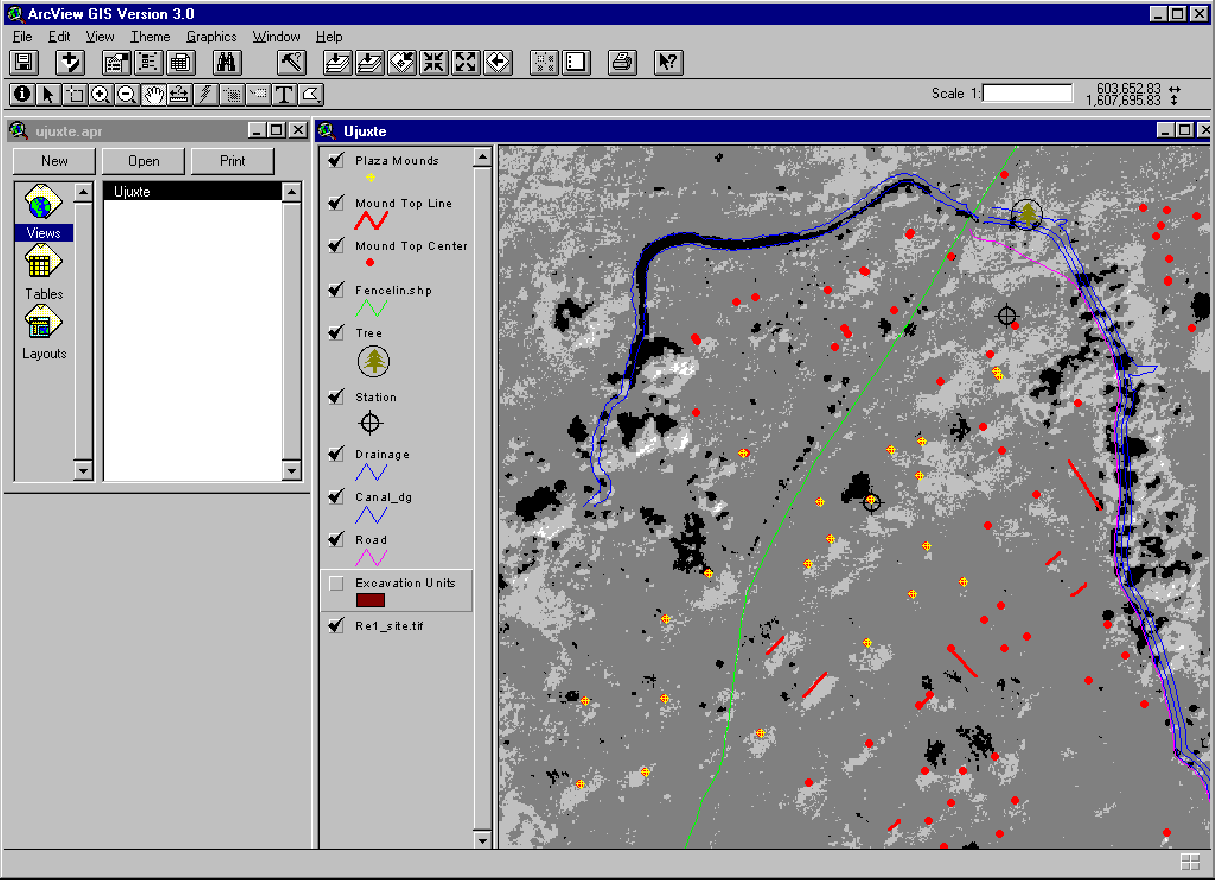
Access to other data layers, such as photos, excavation units and the
database give a detailed description of the entire site.
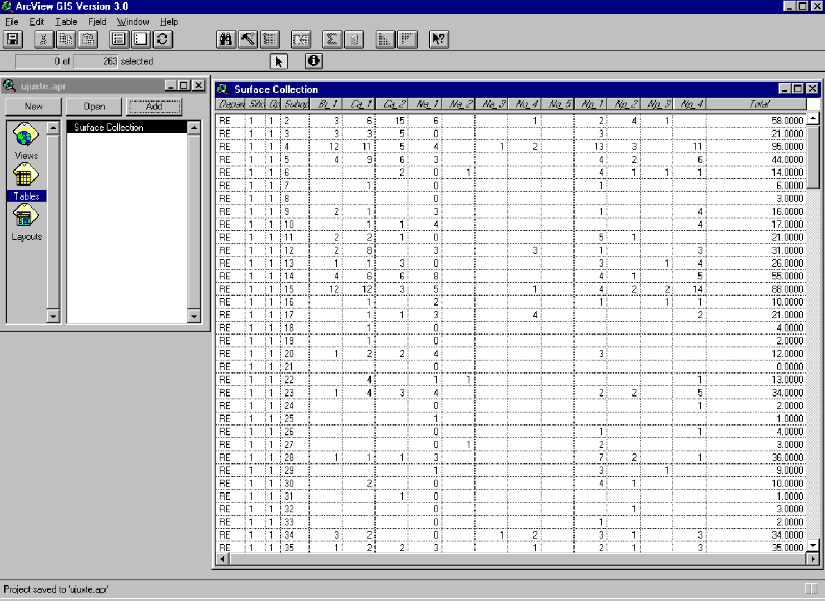 Spatial and
chronological queries on the database are an opportunity for the user to perform
more complex investigations. Annotation and labels already exist on the main
map, but the user is able to add annotation as necessary. Any modifications are
saved to the user's own file for future use without altering the original file.
The resulting maps can then be printed, using certain standard elements, such as
north arrows and scales.
Spatial and
chronological queries on the database are an opportunity for the user to perform
more complex investigations. Annotation and labels already exist on the main
map, but the user is able to add annotation as necessary. Any modifications are
saved to the user's own file for future use without altering the original file.
The resulting maps can then be printed, using certain standard elements, such as
north arrows and scales.
Although the main goal of the archaeological investigation at Ujuxte in 1997 was primarily to map the region, the timely processing and publication of that data was also critical. Data collected using GPS provided a consistent and uniform mapping systems that can be easily converted to other projections and scales. ArcView provided a user friendly platform that could be readily modified to accommodate the less experienced user. This allows the archaeological information from the site to be disseminated in a more timely manner and on a much broader scale. Prehistoric living patterns and therefore archaeological sites are inherently spatial entities that easily lend themselves to GIS. Unfortunately, GIS is rarely used due to its prohibitive cost and learning curve. Perhaps, future investigations can be modeled after a similar prototype that will bring world-wide archaeological sites to a broader public audience.
Thanks to Michael Love, the principle archaeologist at Ujuxte and to Professor William Poe, who leads the field school from Sonoma State. Both provided assistence in the field that made this project possible.