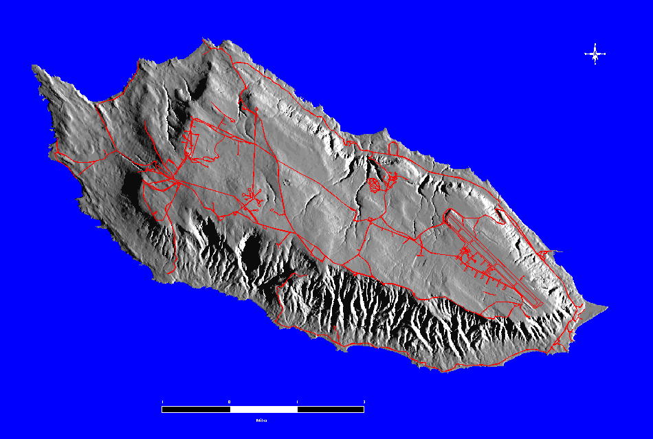
Figure 1. Hillshade of San Nicolas Island and Road Network
Kevin Casaus, D. Phillip Guertin, Barbara Ball, Michael Kunzmann,
Thomas W. Keeney
Fulfilling the military mission at a Department of Defense (DoD) facility, while simultaneously mitigating impacts on protected natural and cultural resources, can be a difficult challenge. The problem is exacerbated when resource managers 1) have limited available hardware and software and 2) protected resources have disparate spatial and temporal distributions and relative importance. The Advanced Resource Technology Group at The University of Arizona has created an ArcInfo GIS database and is developing an ArcView based application to assist Navy resource managers in limiting the impact of naval activities on protected resources on San Nicolas Island (SNI), Point Mugu Naval Air Weapons Station. The Point Mugu Computerized Activity Planning System (PM-CAPS) is a queriable application operating through an ArcView 3 interface. It provides data and graphic representation on restrictions related to specific types of activities on user specified locations on SNI. PM-CAPS compares temporal and spatial locations of resources present in the user defined area to legal and political constraints in order to inform the manager of any restrictions or required mitigation associated with a proposed activity.
The Department of Defense (DoD) is one of the largest federal land managers in the United States with approximately 25 million acres under its control. These lands, which generally have limited public access, are often in relatively pristine condition compared to other public lands and contain vast natural and cultural resources (Rubenson, et al., 1996). Historically, the DoD has managed lands under its control almost exclusively towards the fulfillment of its military mission, with less emphasis given to the management and planning of its natural and cultural resources. However, over the last 25 years, the DoD has invested increasing amounts of time and money towards its environmental program, particularly to ensure compliance with overarching laws such as NEPA and the Endangered Species Act. Currently, many DoD installations are in the process of gathering large amounts of data on the resources within their boundaries in an attempt to inventory, scientifically assess, and manage these resources. Consolidating these disparate data into a common format that allows them to be compared, analyzed, visualized, and utilized for planning and management purposes poses a significant challenge. The use of geographic information systems (GIS) greatly facilitates these data management tasks. GIS and related technologies allow for development of a customized knowledge-based information system that can assist in the planning of military activities while minimizing their impacts on sensitive natural and cultural resources.
This paper will review the introduction of GIS technology to San Nicolas Island (SNI), part of Point Mugu Naval Air Weapons Station (NAWS), and describe the creation of an ArcView application, Point Mugu Computerized Activity Planning System (PM-CAPS), that is being developed to assist with activity planning on SNI. An ArcInfo GIS database for SNI already has been created. The project is currently validating the existing data theme layers, augmenting the GIS with newly acquired data, and utilizing the GIS to create additional layers from existing data. An end product of the project is the development of PM-CAPS, a system that will make it easier for the Resource Manager on SNI to regulate the timing and location of human activities in order to protect the resources present without unduly affecting the military mission of the facility. PM-CAPS compares temporal and spatial locations of resources to legal and user-defined restrictions in order to inform the user of any restrictions or required mitigation associated with certain activities proposed on SNI. It is important to note that, while resource management is a high priority on SNI, resource management is subordinate to the fulfillment of the military mission.
San Nicolas Island is an excellent location for the development of this application for a number of reasons. First, as an island, it is a relatively ecologically closed system. Second, the resource managers for Point Mugu and SNI hold favorable opinions of GIS and are committed to expanding its applications for more effective resource management. This attitude assists in attaining cooperation through all stages of project development and indicates a strong likelihood that PM-CAPS will be utilized upon its completion. Third, SNI contains important legally protected natural and cultural resources. However, because of the island's size, the number of resources present and the number of restrictions that require consideration are of a manageable scope. Lastly, large amounts of data concerning SNI's geographic features, military facilities, and resources already exist in a digital format. Having this dataset available reduces the amount of time and effort required for additional data collection in the fulfillment of this project.
San Nicolas Island is located approximately 65 miles south of Point Mugu Naval Air Weapons Station and 85 miles southwest of Los Angeles, California. It is part of the Channel Islands chain, which consists of eight major offshore islands. SNI is approximately 9 miles by 3.5 miles and has a total land area of almost 13,400 acres.
The island has a relatively flat plateau on the interior with a very steep cliff face dropping to the ocean on the south side and a more gradual slope on the north. Elevations of the southern cliff faces average 500 feet with a maximum island elevation of 907 feet. The beaches are mainly loose sand with large semi-transient sand dunes on the western tip of the island. A large low sand spit extends out from the eastern beach. The interior of the island is a highly eroded rolling mesa with many rills and gullies.
Figure 1. Hillshade of San Nicolas Island and Road Network
San Nicolas Island had been occupied for approximately 7000 years at
the time of its European discovery in 1543 (Schwartz, 1997). The native
population was removed from the island in the early 1800's and the island
was used for intensive sheep grazing for almost 100 years, at which point
the U.S. Navy took possession of SNI and removed the sheep. After World
War II, SNI was incorporated into the Point Mugu Naval Air Weapons Station.
Control of Point Mugu NAWS is maintained from the mainland base (Dulka,
et al., 1993).
The primary military mission at SNI is to serve as a Navy Range Instrumentation test site in support of the Sea Test Range (STR), part of the Naval Air Warfare Center Weapons Division (NAWCWPNSDIV). The STR is used heavily for flight tests of air and sea launched missiles and to test tracking and guidance of such launches. The area between SNI and Point Mugu is covered by close to $100 million worth of communication and tracking equipment and is one of the most heavily instrumented areas in the world (Dulka, et al., 1993).
The Navy considers SNI an ideal site for many of its range functions due to its location. Southern California is home to several major Navy testing, communication, and command installations. SNI also is outside of the reach of most interfering civilian activities. Hazardous weapons systems can occur with less interference to operations and a wider operational safety margin than on the mainland (Dulka, et al., 1993).
San Nicolas Island Range Operations Department has five primary responsibilities in the fulfillment of its mission (Dulka, et al., 1993):
SNI is equipped with facilities supporting metric radar, telemetry, extended area test system optics, communications, microwave, missile launching, drone launching, surveillance radar, and target control. Roads, instrumentation, public works, and other support facilities are located across most areas of the island, with the steep southern cliffs and some of the sandy beaches about the only parts of SNI lacking directly visible human activity.
The main support facilities include an airport with a 10,000 foot paved runway, a power plant, a fuel farm, and over 300 buildings, water tanks, and other above ground structures. Personnel stationed on the island are housed in "Nicktown," a complex in the center of the island that contains housing, recreation and mess halls, and other support facilities. A fairly extensive network of over 50 miles of paved and dirt roads provide access to most areas of the island.
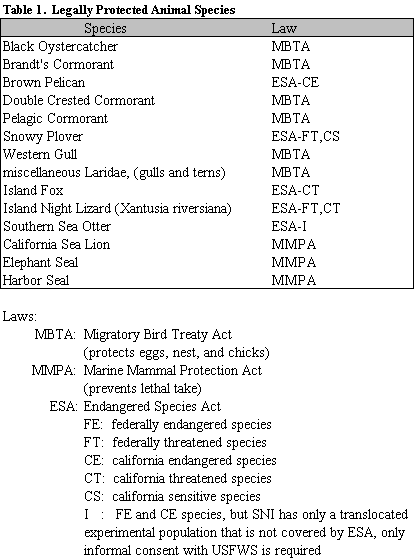
A wide array of natural and cultural resources exist on San Nicolas Island. Many of the plant and animal species found on SNI are taxinomically different from mainland populations and those on other Channel Islands due to their isolation. Some have diverged to the degree that they are categorized as separate species or subspecies (Dulka, et al., 1993). Ten animal or plant species are endemic to SNI or the Channel Islands. The archaeological resources on SNI also are significant in their uniqueness and richness.
A number of federal and state laws regulate the activities that can occur where many of these resources are found. SNI is covered by both federal and California state laws on different parts of the island. Federal land is not subject to state law, excluding most of SNI from California regulation. However, all land below the mean high is considered state land and must comply with state law. The federal and state regulations are augmented by further constraints imposed by the resource managers of Point Mugu NAWS and SNI.
SNI has few resident species, but many of those that occur are considered significant and are afforded protection. The island also is utilized seasonally as a nesting or feeding site and as a stopover by dozens of bird species. Four species of marine mammals that are found on SNI beaches are protected by the Marine Mammal Protection Act. In all, over fifteen animal species are found on the island that receive some measure of protection under a variety of federal and state laws.
Approximately 230 plant species have been identified on SNI. Eighteen
of these are endemic to the Channel Islands. Eleven have federal or state
legal status; the remaining seven lack legal protection, but are considered
sensitive species and receive some protection as a matter of Point Mugu
policy.
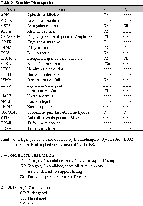
Also of concern to resource managers are thirteen non-native introduced plant species. These plants are invasive opportunistic colonizers brought to the island either intentionally or accidentally. While eradication programs are not currently being undertaken, efforts to prevent their spreading into new areas are desired (Junak, et al., 1996a; Junak, et al., 1996b).
Over 500 archaeological sites have been identified and recorded on SNI (Dulka, et al., 1993). However, it can be difficult to delineate precise site boundaries because of the heavy utilization of most of the island and site migration due to alluvial and erosional activities. Sites are categorized by the type of activity or activities that occurred there, based on material remains. Site types identified on SNI include buried midden, cobble processing, camping, lithic manufacturing, abalone processing, and multiple use sites.
Many of the artifacts recovered from SNI sites are extremely valuable, both monetarily and in their ability to further the understanding of the Chumash Indian culture. These sites are highly vulnerable to most types of surface or subsurface disturbances. Cultural resources on SNI are protected by a combination of state and federal laws. The sites and artifacts on them are covered by the Antiquities Act and the National Historic Preservation Act. Under the National Environmental Protection Act, the Commander of Point Mugu NAWS is responsible for local protection, care, and control of all archaeological sites in his jurisdiction (Dulka, et al., 1993).
There are other resources on SNI that receive various degrees of protection, either as a matter of law or Point Mugu NAWS policy. For example wetland areas are protected by Section 404 of the Clean Water Act. Large sand dunes on the western end of SNI are not legally protected, but are closed off to surface activities by the Point Mugu Resource Manager due to their uniqueness and fragility.
Data have been collected on each of these resources through various means and exist in a variety of formats. For example, the Cooperative Park Studies Unit at The University of Arizona conducted a study of SNI flora and published the findings as a two part technical report (Junak, et al., 1996). Some resources have been studied by more than one entity and at different times. For example, the archaeological resources have been surveyed and tested by three different contractors since the 1950's.
Interpretation and implementation of resource protection laws and policies is a poorly defined process, leaving specific "on the ground" policies largely to the discretion of the Point Mugu NAWS Resource Manager. Most laws designed for natural and cultural resource management and protection lack specific directions as to how they are to be enacted, monitored, and enforced. For example, the Migratory Bird Treaty Act forbids the disturbance or injury of the eggs, nest, or chicks of the Brandt's Cormorant bird species. The Point Mugu NAWS Resource Manager chooses to meet this directive by closing off nesting areas to personnel during certain months. Other resources, such as archaeological sites, require year round protection from certain destructive activities. Determining the best way to implement resource protection policy is a difficult challenge. At all times, minimizing the impact of resource protection on the military mission is a high priority.
Most of the resource protection strategies on SNI consist of excluding or restricting certain activities from areas containing protected resources. For example, beach areas utilized by elephant seals are restricted from human access. Other resources require some type of mitigation before certain activities are allowed. Any construction within a certain distance of some of the archaeological sites requires the presence of a monitor during the activity to ensure that the site is not disturbed.
Determining spatial extents of protected areas for each resource is another difficulty for resource managers, particularly for animal and plant species. Distribution and concentrations of a species tend to vary by season, activity, or year. This problem is compounded in instances where more than one study has been conducted on the same resource or that the study extends through multiple years. This is a problem even for cultural resources, which are more static than living species; different surveys have been conducted on SNI, each resulting in different site distribution maps.
Most resource studies on SNI have been conducted at different times by different contractors. This has resulted in creation of non-uniform data that have been stored in a variety of formats. The disparity in data format and attributional variability make it difficult to compare and query data from different studies.
In addition, several of the natural resources have sensitivities that vary temporally, further complicating the decision making process. For example, many animal species are most vulnerable to disturbance or are given specific legal protection during breeding season. Establishing policies that reflect the dynamic nature of temporal or spatial distributions of resources is a serious challenge.
The resource managers at SNI and Point Mugu are responsible for creating and implementing a series of policies that:
The method of determining specific resource protections, historically, has been largely subjective at the discretion of the SNI and Point Mugu resource managers. For example, if the Range Operations Division wanted to conduct a certain activity on the island, such as the establishment of a utility pipeline, they would consult the SNI Resource Manager on any possible constraints in the proposed route. The Resource Manager would make determinations based on the presence or absence of any protected resources in the area, and would consult resource distribution maps and other sources of information. While this process has been somewhat effective in the past, it is subjective in nature and is becoming increasingly complex with the addition of data and the replacement of resource division staff.
In 1994, Point Mugu NAWS contracted the University of Arizona Advanced Resource Technology (ART) Group to establish a GIS for them as a means of storing, analyzing, and visualizing their data for SNI. Hardware and software resources at SNI were minimal, with no GIS capabilities prior to the contract. None of the resource managers at Point Mugu NAWS was proficient or familiar with developing or operating a GIS.
The first two years of the project consisted mainly of developing basic coverages to serve as uniform standards for subsequent spatial data. Geographic features were digitized from DoD general development maps (GDM) and ArcInfo coverages were created. These themes included features such as contours captured at twenty-five foot and selected five foot intervals, over 1500 spot elevations, streams, roads, and buildings, water tanks, and other facilities.
Coverages of natural and cultural resources were created from existing non-digital data formats. These themes show the spatial extents of each of the resources of concern on SNI. Most of the species distribution and archaeological site boundary themes were digitized from polygons that were originally hand drawn on GDMs from original field survey maps.
However, additional data analysis was required to produce themes showing the full spatial extents of protected areas for some of the resources. For example, human activity is not allowed to occur within sight of any of the pinniped species during its breeding season. Surveys had defined the beach areas used for breeding by each of the species, but not the areas within their view. Using these known breeding areas and digital elevation models, viewsheds for each of the species were calculated.
These themes are updated as additional data are collected and accuracy checking continues. For example, a contractor is currently relocating previously recorded archaeological sites on SNI and redefining site boundaries using global positioning system technology. This is expected to result in more precise and accurate GIS themes.
In the three years that SNI has had access to GIS technology, it has been utilized mostly for map production and archaeological site re-identification. Hard copy plots have been created of most of the resource and feature themes for data visualization purposes. While this was one of the original goals for establishing a GIS for SNI, Point Mugu NAWS resource managers also desire to use the technology for data analysis and to support decision making.
The Point Mugu Computerized Activity Planning System is an application designed to assist in planning military activities on SNI to minimize their impact on sensitive resources. It is intended for use by any activity planner, but does not supplant the authority of the Point Mugu NAWS and the SNI Resource Managers. Theoretically, users should receive the same information from PM-CAPS as they would directly from the Resource Manager.
Using an ArcView interface, it informs the user of the presence of protected resources and the restrictions that apply to certain types of activities in a specified area. Additional information is given about the impacted resources, such as the applicable laws or regulations and any required mitigation. The user also can display a map showing the sensitivity of areas on SNI, on a scale of low, medium, or high, based on the resources present and the degree of protection that they are afforded relative to other areas.
PM-CAPS was created using ArcView Version 3. It is a customization of the out-of-the-box user interface via ArcView customization options, such as adding or deleting tool buttons, and the creation or modification of Avenue scripts, the ArcView scripting language. PM-CAPS creates additional data analysis and visualization options and tools for the user than the standard ArcView interface, and also removes certain user options deemed unnecessary for the operation of the application.
The ultimate goal in designing PM-CAPS is to create an application that provides rapid, consistent, and accurate information in a way that the Resource Manager considers superior to standard methods of military activity planning and decision making. If this goal is achieved, it is believed that PM-CAPS will be adopted by the Resource Manager. This goal will be accomplished if the application meets the following criteria:
At this time, a functional prototype of PM-CAPS is being completed.
A more robust application will be designed after the prototype undergoes
a testing and validation period by Point Mugu NAWS resource managers.
PM-CAPS is started from the standard ArcView project window by depressing an application pushbutton. This initiates a script that opens a view window and loads the starting view themes. The user sees the island footprint, roads, and certain place names (eg. Dutch Harbor), which serve as points of reference. Custom pushbuttons allow the user to load and display or delete additional themes, such as contours, buildings and facilities, or the individual resource themes. The location of archaeological sites is restricted information and PM-CAPS does not allow the user to display that theme. The user can turn themes on and off throughout the session. Standard view document pushbuttons and tool buttons that allow the user to manipulate the view, such as zoom in/out or pan, still exist.
The activity planning function of PM-CAPS is started with the user defining the area to be evaluated. This is initiated by depressing either of two custom tool buttons. One selects the entire island. The other button allows the user to define a polygon where the proposed activity would occur. If this button is depressed, the user manipulates the cursor with the mouse to define a polygon. When the polygon is completed, a message box appears that asks the user if she accepts the polygon and wishes to proceed. A negative response ends the process; the user would depress one of the two custom tool buttons to start over.
If the polygon is accepted, a message box asks the user either to select the type of activity he is proposing from a list of four pre-defined activity class types. The activity class list was created specifically for the PM-CAPS application and it is believed that the impact of any proposed activity can be classified into one or more of the options. These options are: 1) walk-over, 2) fly-over, 3) surface construction, or 4) sub-surface construction.
Another message box then prompts the operator to select the option of either determining the specific resources affected and the accompanying restrictions, or displaying a relative sensitivity map of the area. If the user selects the first option, PM-CAPS will determine if protected resources are present in the defined activity area. It then will create and display a table with the fields:
The resource polygons, with the exception of archaeological sites, within the user defined area also are drawn and displayed in order to assist the user in determining alternate activity areas.
This process is performed mainly through a linking of existing Avenue scripts written for separate functions. It combines modified versions of the View.NewTheme, SymWin.DisplayFillPanel, and View.SelectByTheme scripts to create a new polygon theme of the activity area and overlay it with the resource themes. The above mentioned fields from the polygon attribute tables (.pat) of the resource coverages and linked look up tables are combined into a single table and displayed as a new window.
After the table is displayed, the operator can depress a pushbutton to determine the restrictions of another activity class in the same defined area. The user also can start the process over and define a new activity area polygon.
If the operator selects the relative sensitivity option instead of the specific resource information option, PM-CAPS will intersect the activity area polygon with an existing relative sensitivity theme specific to the activity type that he selected. A relative sensitivity theme was created for each activity class. It is a solid fill polygon theme that classifies each area of SNI as "high," "medium," or "low" sensitivity to the activity based on a combination of factors. The sensitivity determination includes such things as number of resources present, each resource's sensitivity relative to other resources based on legal standing and Point Mugu NAWS and SNI resource manager's determinations (eg. an endangered species compared to a threatened species), and severity of restrictions (eg. legal prohibition of the activity as opposed to a recommendation for alternate site selection).
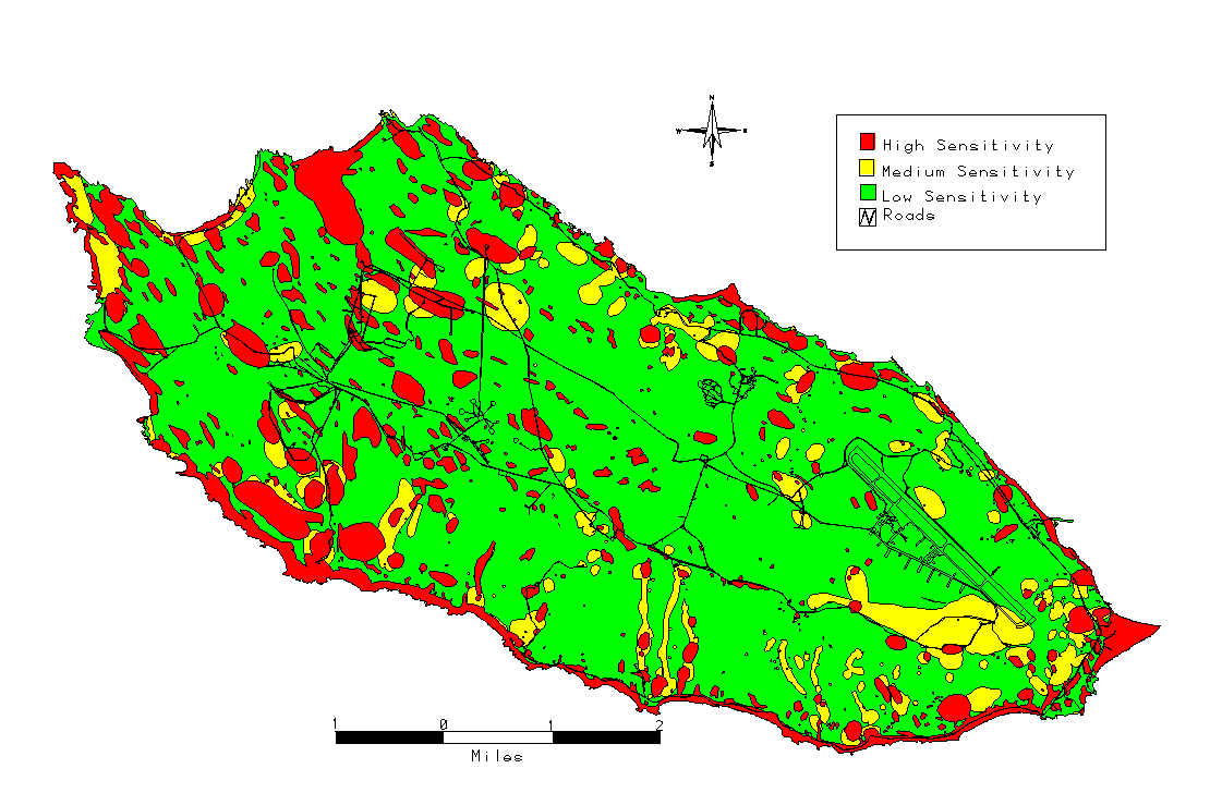
Figure 2. Subsurface Construction Sensitivity
The PM-CAPS prototype will be evaluated by the Point Mugu NAWS and SNI Resource Managers. The expected evaluation will consist of establishing hypothetical, but plausible, activity scenarios. The Resource Manager will be requested to determine the resources affected by the proposed activity and the restrictions that would apply to each scenario. The same situation then would be entered into the PM-CAPS prototype.
The results from the two sources will be compared to examine their similarity. It is expected that both methods should identify the presence of any resources in the proposed area equally well since both have the same spatial extent data. Any discrepancies between the two outputs are expected to be in the specific restriction and mitigation information. While some of these determinations are simple, such as a prohibition of a certain activity where a particular resource is present, others can be somewhat subjective. For example, the Resource Manager may allow an individual to walk through an area where a sensitive plant occurs if the person is trained to recognize the plant and knows to avoid it, while PM-CAPS is programmed only to reflect that this activity is forbidden in that area.
It is possible to make later versions of PM-CAPS more robust in the amount of information the application provides the user in an attempt to account for more variations of the activity classes, but it is not logistically reasonable to attempt to provide a specific response for every conceivable scenario.
Updating PM-CAPS to reflect additional or updated information is technically simple since the information displayed to the operator consists of the contents of specified database table fields. Each look up table can be modified individually without affecting the data for any other resource or the performance of the application itself. The scripts that control the application do not require modification.
PM-CAPS also can be expanded to provide different information for different
polygons of a particular resource. For example, non-digital data that currently
exist concerning density of a plant species within each identified polygon
for its theme could be used to reflect a corresponding different relative
sensitivity for each polygon. Such changes would be accomplished by adding
additional fields in the species theme's (.pat). The application can be
updated to include additional resource themes should the data become available,
provided that the .pat files contain the proper fields and data.
Point Mugu NAWS has made a commitment to automate their resource planning and management through the establishment and use of a GIS. This is allowing resource managers to fulfill the military mission of SNI as a naval weapons testing range while minimizing the negative impacts on certain protected resources. This is a difficult challenge and is exacerbated by the disparity in amounts and formats of current data, the vast differences in the resources themselves, and the range of restrictions imposed on disturbing different resources.
The PM-CAPS application assists managers in determining the restrictions
that exist for siting certain activities and helps them to identify more
suitable locations. The system is not intended to supplant the role of
the Resource Manager, but to serve as a tool in the decision making process.
A completed PM-CAPS application will be a useful, flexible tool that could
be updated to incorporate additional information and reflect changing resource
values.
Dulka, K., M. Dalke, and L. Barker, 1993. San Nicolas Island and Santa Cruz Island Site Manual. Naval Air Warfare Center Weapons Division. Point Mugu, CA.
Junak, S., W. L., Halvorson, C. Schwemm, and T. Keeney, 1996a. Sensitive Plants of San Nicolas Island, California (Phase 1). Technical Report No. 51. NBS-CPSU/UA. Tucson, AZ. 91 pp.
Junak, S., W. L., Halvorson, C. Schwemm, and T. Keeney, 1996b. Sensitive Plants of San Nicolas Island, California (Phase 2). Technical Report No. 57. NBS-CPSU/UA. Tucson, AZ. 104 pp.
Rubenson, D., M.D. Millot, G. Farnsworth, and J. Aroesty, 1996. More Than 25 Million Acres? DoD as a Federal, Natural, and Cultural Resource Manager, National Defense Research Institute, Prepared for the Office of the Secretary of Defense. 114 pp.
Schwartz, S., 1997. Personal communication. Archaeologist, Point Mugu NAWS.
This project has been made possible by the support and funding received from the Naval Air Weapons Station (NAWS), Point Mugu, Environmental Division and Department of Defense Legacy Resources Management Program. The authors would like to thank Steve Schwartz and Grace Smith from NAWS, Point Mugu, Environmental Division for their support and insights on the complex resource problems on San Nicolas Island. We also would like to thank Richard Rugen from Natural Resource Management, Naval Faciliteis Engineering Support Facilities, San Bruno for his support and Craig Wissler from the Advanced Resource Technology Group, University of Arizona for his technical assistance.
Kevin Casaus is a Master of Science student in Renewable Natural Resource Studies at the University of Arizona. He holds a research assistantship with the Advanced Resource Technology Group. Correspondence may be sent to: The University of Arizona, Biological Sciences East Room 207, Tucson, AZ 85721. His telephone is (520) 621-3045. E-mail: kcasaus@nexus.srnr.arizona.edu
D. Phillip Guertin is an Associate Professor within the School of Renewable Natural Resources, Advanced Resource Technology Group, University of Arizona. Correspondence may be sent to: The University of Arizona, Biological Sciences East Room 203, Tucson, AZ, 85721. His telephone is (520) 621-1723, FAX (520) 621-8801. E-mail: phil@nexus.srnr.arizona.edu
Barbara Ball is a Research Specialist with the Advanced Resource Technology Group. Correspondence may be sent to: The University of Arizona, Biological Sciences East Room 207, Tucson, AZ, 85721. Her telephone is (520) 621-7270, FAX (520) 621-3045. E-mail: barb@nexus.srnr.arizona.edu
Michael Kunzmann is an ecologist with the US Geological Service- Biological Resource Division. He works for the National Park Service Cooperative Park Studies Unit. Correspondence may be sent to: The University of Arizona, Biological Sciences East Room 125, Tucson, AZ, 85721. His telephone is (520) 621-7282, FAX (520) 670-5001. E-mail: mrsk@npscpsu.srnr.arizona.edu
Thomas W. Keeney is an ecologist for the NAWS Point Mugu. Correspondence may be sent to: Environmental Division, Point Mugu Naval Air Weapons Station, Point Mugu, CA. 93042-5000. His telephone is (805) 989-3808. E-mail: keeneyt@smtpgate.mugu.navy.mil