Geographic Information Systems technology is playing a significant role and emerging as one of the most effective information management tools in the Petroleum Industry. In recent years, there has been tremendous growth in the GIS technology. This growth has offered time and cost saving benefits to the Oil and Gas Industry. GIS technology provides a set of flexible and sophisticated tools for handling data. Because of its flexibility many commercial GIS software packages are in use by the Industry, one of which is ArcView.
ArcView is a powerful, easy-to-use software tool that brings Geographic Information to your desktop. As GIS grows the need to document and share databases become increasingly important. ArcView provides the power to quickly visualize, query, and analyze the data together with existing databases and to explore it in new ways. ArcView is highly integrated with other applications, including databases, spreadsheets, and windows on-line help system, providing a more comprehensive environment for analysis.
The defining issue for this project is the constantly changing offshore lease data and the lack of a PC-based application interface to interactively analyze and update this data. Our solution was to develop an easy-to-use desktop GIS application to assist Land Negotiators of Amoco Offshore Exploration Teams in maintaining and reporting updated lease information. This paper describes the development of an ArcView based Lease Query System (LQS) application that allow users to interactively query offshore blocks and analyze the Mineral Management Service lease data. The Windows Help System is utilized as an application interface which, in addition to complete access to metadata and on-line help, integrates with ArcView by executing Avenue scripts directly from the help file. The LQS application allows users to click on a county from the list of counties(Offshore areas) in the help file and then allows query and analysis on that county using customized analyses tools in ArcView. The data linkage between ArcView and the lease database in MicroSoft Access is established through Object Data Base Connectivity(ODBC) to instantly reflect the updates in the database in ArcView tables. In addition, this application utilizes Dynamic Data Exchange(DDE) links to MicroSoft Excel to generate reports. The main objective of this application is to provide the end users with accurate and up-to-date lease information at their finger tips.
Geographic Information Systems technology is an excellent tool for the land lease management. GIS has multi-function capabilities that empower the user to create maps, charts, and reports. It also enables the users to access and perform analysis on the database through a map driven interface.
Many factors must be considered to achieve the goal of providing a powerful easy-to-use Desktop GIS Application. These factors include integration with existing databases, documentation, and providing query and analysis capabilities through customization.
In the past, Land Negotiators have had difficulty in analyzing the lease data. This is due to several factors.
In order to overcome these problems, we feel that the key to improving this process was to develop an ArcView based GIS application that allows the Land Negotiators to query and analyze the data at their finger tips. This paper discusses the development of the LQS application including application design, implementation of the application, and future development.
The design process identified the need to systematically examine the purpose, the inputs, and the desired outputs of the application. Before designing the powerful, easy-to-use GIS application, the following design goals were outlined:
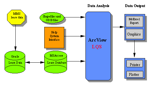
The following flow chart illustrates the interaction between the various components of the LQS system.
The Lease Query System provides a set of dynamic and powerful GIS tools for analyzing, visualizing and reporting lease information to assist the land negotiators in decision-making. The LQS interface is a simplified version of the standard ArcView. LQS, in addition to providing customized menu and button tools, preserves only the most basic of ArcView functionality - selection, identification, pan, and zoom - and allows no write or save operations. The simplicity of the interface makes it an easy-to-use query and analysis tool for the land negotiators.
Lease data is down loaded from the internet at Minerals Management Service, Gulf of Mexico OCS Region�s web site. This data includes information on the status of leases along with the geographic locations, effective date, surface acreage and other data elements specific to the lease. This data is stored and maintained in the Oracle database. The boundary track data is extracted from the land survey data stored in ArcInfo map Library. This data is compartmentalized into various county themes. Each of the county themes is symbolized and saved as an Object Data Base(ODB) file outside of the ArcView project file and is loaded when needed by the application. This process keeps the ArcView project file from becoming prohibitively large and also allows users faster access to the system.
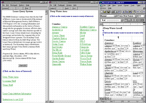
Windows help system is utilized as an interface for the application which, in addition to providing complete access to metadata and on-line help, integrates with ArcView by executing Avenue scripts directly from the help file. ArcView provides a Dynamic Link Library (DLL) for use with WinHelp that allows the user to execute Avenue programs when a hot spot in the help file is clicked. LQS help system is a hypertext document that allows the users to browse through the list of counties in three major boundary groups, Deep Water Area, Louisiana Shelf, and Texas Shelf. The LQS is started by clicking on a button in the help file. When the users click on a specific county in the help file, the help system executes the Avenue program contained in LQS passing county name as an argument to it. The Avenue program then loads the county theme saved as an ODB file and zooms to it. The Figure 2 illustrates the organization of the help file and the dissection of the Rich Text Format(RTF) file in Microsoft word.
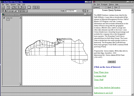
The MSAccess database was created using dynamic linkage to the Lease data stored in an Oracle database through ODBC. This process enables the lease data manager to update the lease data in the PC environment and allows the users faster access visualize the data in LQS. The linkage between MSAccess database and LQS was established through ODBC. Figure 3. illustrates the LQS Application.
A suite of Avenue programs allows the user to run a set of analyses, queries, and reports on the lease data. The following is a brief description of some of important scripts.
The menu choice "link the lease data" allow users to run a SQL query on the lease database in MSAccess through SQL connect and enables the land negotiator to interact with the database to perform analysis.The Avenue program also enables users to choose between Active and Historical leases and generates a color coded theme map to quickly analyze the lease sale process. Figure 4. illustrates a popup dialog box prompting the user to select between Active and Historical leases.
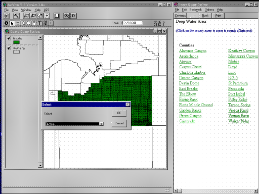
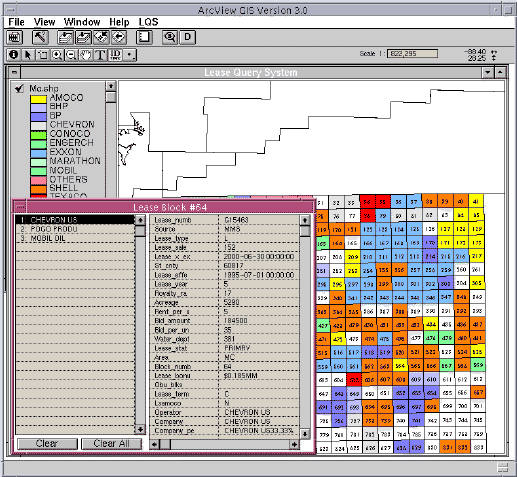
The "idlink" tool enables users to click on a block and identify all of the lease information associated with that block. This means all the lease owners associated with a block will be shown in the identify window by a single click on the block. Figure 5. illustrates the results of the idlink tool.
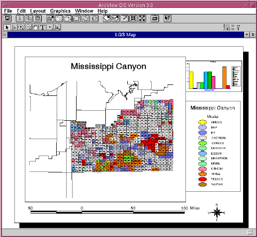
The menu choice "Generate Map" allows the user to create a color coded theme map from the current view. The user is prompted for a title, chart, legend,scale and paper dimensions. Figure 6. illustrates the map generated by LQS.
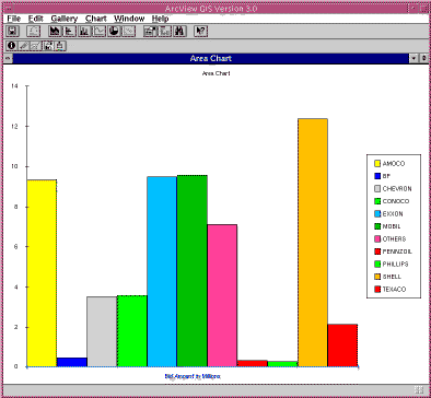
The menu choice "Generate Chart" allows the user to create a pie or a column chart to assess the leasehold and tracking of competitor activity. Figure 7 illustrates the chart generated by LQS.
The "zoom to block" allows the user to interactively zoom to the block of interest.
The menu choice "Generate XL report" allows the user to generate an excel spread sheet report of their analysis on a specified block. This script establishes a DDE conversation with MSExcel and prompts the user to select the field attributes to be written to an Excel spread sheet.
The menu choice "Generate text report" allows the user to generate a word document report of their analysis on a specified block.
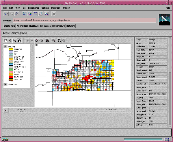
The result of this project was of a great value to the Land Negotiators, and has made it possible to start thinking about new ways to enhance it. At this time, ArcView Internet Map Server is in beta release. This application provides interactive GIS functionality over the World Wide Web in a client /server environment and provides integrated access to a wealth of geographic and related information stored in a wide variety of data formats including shapefiles, ArcInfo coverages, SDE data, spreadsheets, and databases. With the addition of the ArcView Internet Map Server extension, large amounts of existing geographic information can be deployed and accessed via the Internet as well as within organizational Intranets. The LQS product team is now considering this new functionality in ArcView3.0, and evaluating it to use it in deploying the LQS application on the organization's intranet so that Land Negotiators in the Amoco Offshore exploration teams can get immediate access to the information they needed. Figure 8. illustrates the LQS application on the web.
The team is also considering the capabilities of ArcView Dialog Designer extension which provides new tools to customize ArcView's interface. This extension, in addition to providing integrated dialogs that don't need to communicate through DDE or RPC , provides a cross platform development environment that works on PC, and UNIX. The LQS application can be further enhanced with more added capabilities through dialog designer.
LQS application demonstrates the efforts to develop a powerful and easy to use desktop GIS application for analyzing and reporting the offshore lease data. LQS can be used as a invaluable tool for the land lease management. LQS integration with a geographically referenced land database enables the land negotiators to interact with the database and perform analysis on a daily basis. The color coded theme map, charting, and reporting functionality enable rapid assessment of leasehold and tracking of competitor activity.
The authors would like to express their appreciation to their managers Ronnie Powell and John Emhof at Amoco Corporation for their editing, encouragement and continued support.
Denise P. Adams
GeoScience Technical Specialist
Amoco Corporation
501 WestLake Park Boulevard
Houston, TX 77079-3092
Telephone:(281)-366-4407
E-mail:dpadams@amoco.com
Willie Mae Moore
GeoScience Technical Specialist
Amoco Corporation
501 WestLake Park Boulevard
Houston, TX 77079-3092
Telephone:(281)-366-3504
E-mail:wmmoore@amoco.com