Hassan Kasraie & Paul Van Zuyle
Near Real-Time Hydrologic Modeling & Forecasting using GIS
Abstract
Watersheds of Southern California are subject to frequent flash flooding during the winter months. These floods cause major damage and take lives. In the event of a forecasted storm, flood control engineers and emergency response personnel involved in the monitoring of flood-prone areas are put in the difficult position of predicting floods, issuing adequate and timely warnings, and developing evacuation plans with limited information to draw on.
This paper investigates the use of Geographic Information System (GIS) for the purpose of identifying flood-prone areas in Ventura County, California on a parcel-level basis in real time. A case study is presented as a blueprint of how a specialized flood control application could be developed for this dynamic process in which weather and river conditions are constantly changing.
The latest releases of ArcView, Spatial Analyst, ArcInfo and ArcGRID, all by Esri, Inc., have been used for this application, in addition to the US Corps of Engineers (COE) Flood Hydrograph Package software (HEC-1) and the River Analysis System (HEC-RAS).
Overview
Since the major flood of 1969, Ventura County has experienced numerous flood events that have cost millions of dollars' worth of damage to our flood control facilities and our infrastructure. The Ventura County Flood Control District's existing network of self-reporting raingages and streamgages is doing a good job of alerting emergency response teams to incoming flood waves in some of our natural streams. However, what is missing is adequate coverage in our major population and urban areas. In addition, we lack adequate flood plain maps that show the extent of potential flooding in high-risk areas. The creation of these flood plain maps in real time is a rather difficult task in that flood boundaries change as the runoff changes, and the forecasted runoff peak values change as the watershed and weather conditions change. Maps created for the purpose of establishing flood insurance rates are developed for fixed 100-year and 500-year return frequencies, and in many cases the base topography or the hydrology have changed since the maps were prepared. Consequently there is often little information on which to base a major evacuation.
GIS can be a significant tool to use before, during, and after flood emergencies in Ventura County. This paper presents a new approach to determining flood-prone areas in our County on a parcel-level basis in real time. During flood emergencies, substantial progress will be made if we can pinpoint areas that are most susceptible to immediate flooding, instead of issuing a broad warning that may apply to an entire community. Because of the complexity of the matter and staffing needs, this sort of analysis will realistically take one to two hours to complete, and therefore we cannot claim it is a true 'real time' evaluation. This new approach has been developed not to replace existing flood warning measures, but merely to augment them.
Methodology
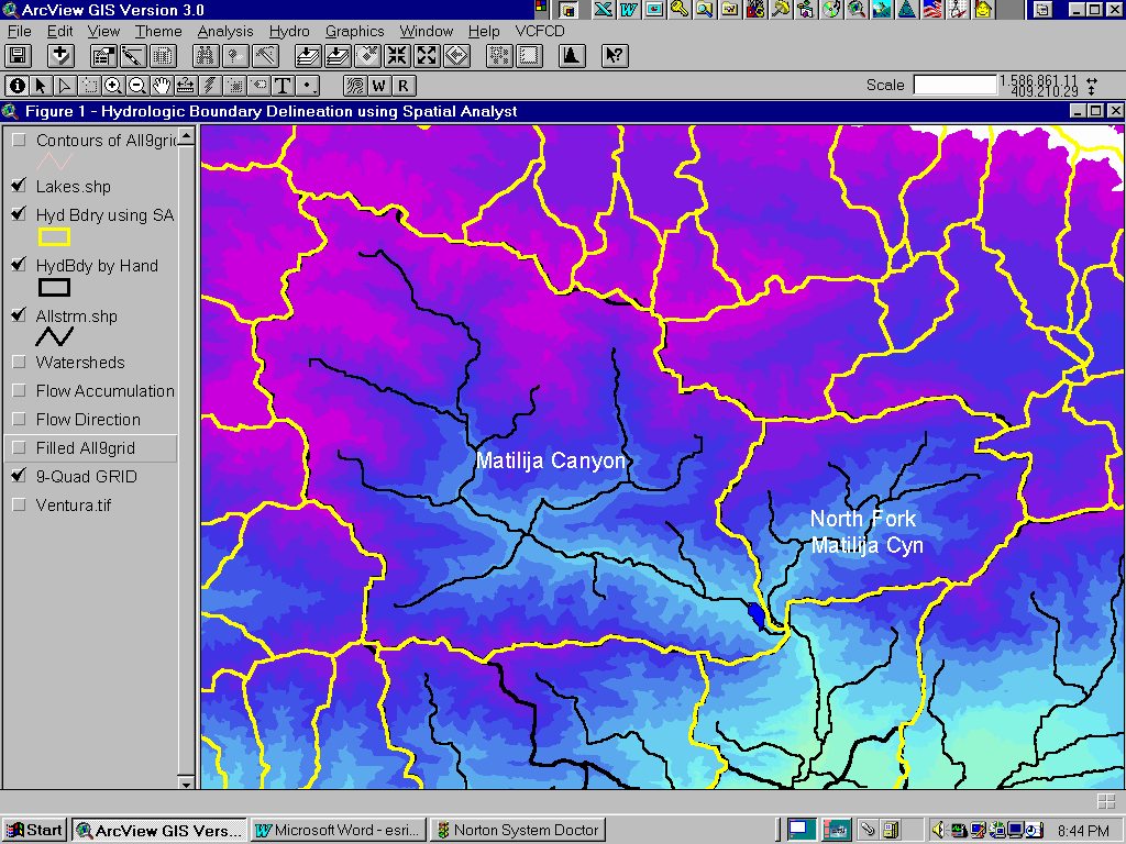
What is needed is a mechanism by which flood control engineers can determine potential flooding areas in our major river system and urban areas for a given quantitative rainfall prediction. As daunting as this task may appear, it is quite possible to develop procedures, parameters, and models before the rainy season begins, so that we can benefit from them during the winter months. GIS provides flood control engineers with many new opportunities that never existed before. Now we can look at the raster USGS 7.5-minute quad maps and 30-meter Digital Elevation Models (DEMs), the latest 5-meter radar images and DEMs of our county, and the newly completed parcel-level database at the same time. All these different data sources come together nicely under the unifying umbrella of GIS. What is especially useful are the new hydrologic tools available in Spatial Analyst that can automatically delineate watershed boundaries and stream network on a small or large scale using the DEMs as the background grid (see Figure 1).
The case study presented here involves a hydrologic model that was used during the March 10, 1995 flood of Ventura River in western Ventura County. The flooding incident involved evacuation and subsequent flooding of an RV park built at the mouth of Ventura River, closure of State Highway 101, and partial damage and closure of the Main Street bridge (see Figure 4).
Nine 30-meter DEM grid files were combined and used to arrive at watershed boundaries, stream network, and flow lengths for each sub-basin. The newly released vegetative and land use coverages prepared by Southern California Association of Governments (SCAG) were used in conjunction with the available hydrologic soil groups to determine hydrologic parameters more accurately. The first immediate benefit of this exercise was that watershed parameters were calculated accurately. These would normally be estimated due to the enormous time involved in manual digitizing or planimetry.
Unfortunately going from a Quantitative Precipitation Forecast (QPF) to the corresponding flood plain map superimposed on parcel-level property ownership coverage is not a one-step operation, and several technical steps must be carried out, as follows:
The following pages discuss in detail the required procedure for the above steps.
Primary Goal: TO IDENTIFY AREAS IN VENTURA COUNTY WHICH MAY BE AFFECTED BY A FORECASTED STORM EVENT ON A PARCEL-LEVEL BASIS IN REAL TIME
Step 1. Procedure for delineating watershed boundaries and stream network
Figure 1. Watershed boundary and stream network delineation using Spatial Analyst
Step 2. Procedure for developing hydrologic parameters
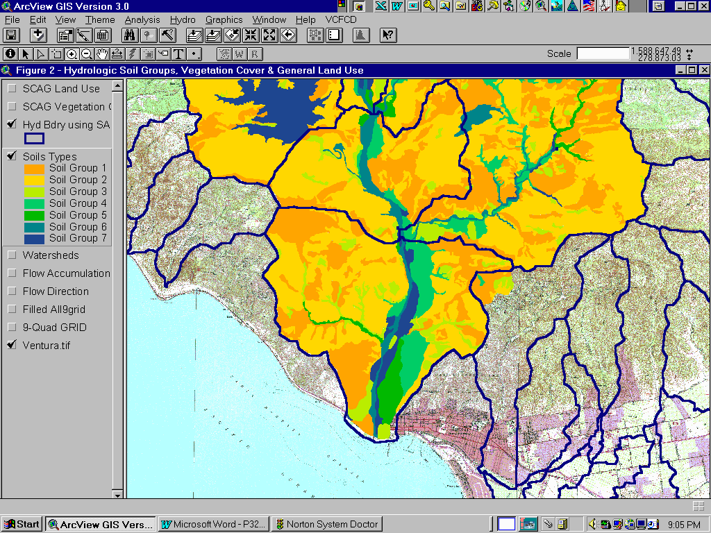
Figure 2. Overlay of hydrologic soil groups, land use, and vegetation cover on top of watershed sub-boundaries is performed to determine basic modeling parameters
Step 3. Procedure for rainfall distribution & watershed modeling
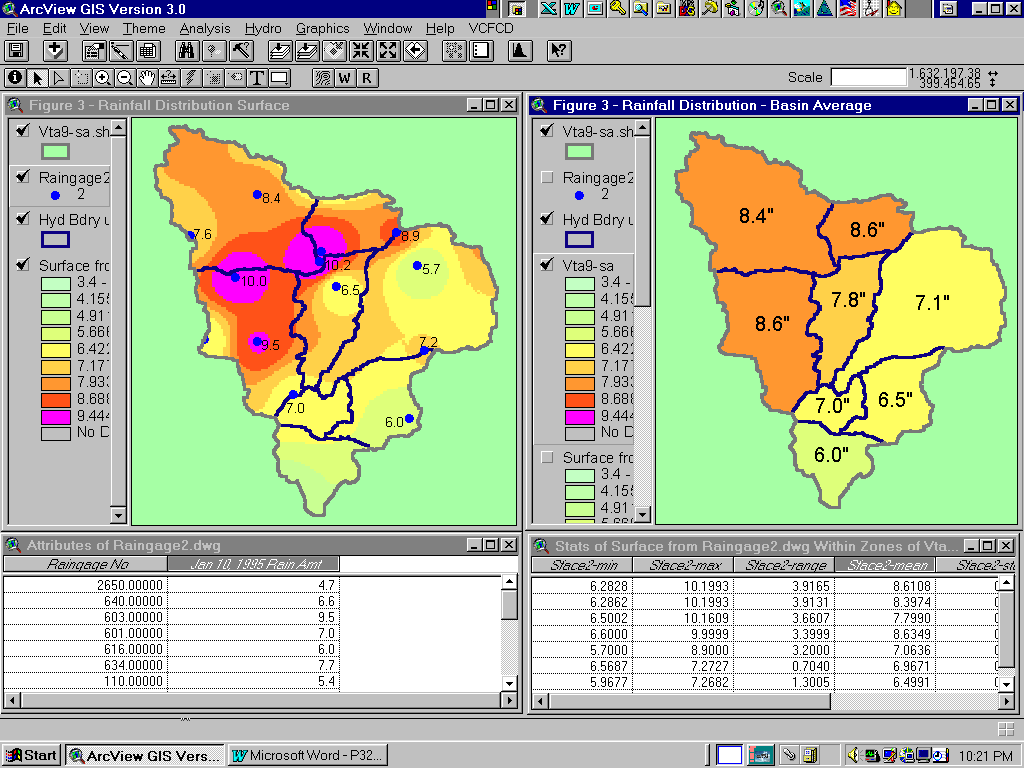
Figure 3. Basin-wide rainfall is a key input parameter for hydrologic analysis
Step 4. Procedure for flood plain analysis and overlay of flood plain maps
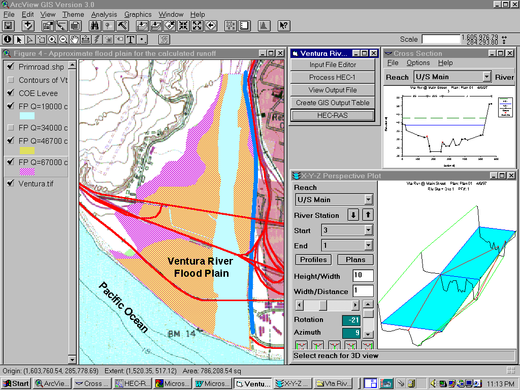
Figure 4. Flood plain grid theme or polygons can be superimposed on top of the property ownership coverage (not shown) for quick flood assessment
Step 5. Dissemination of emergency flood plain maps
Why should we use GIS?
Our communities can benefit from a dual-purpose hydrologic and flood plain master plan. What is meant by dual-purpose is the development of a single hydrologic model, both for static design conditions when the rainfall and watershed saturation conditions are fixed in time, as well as during real-time evaluations. GIS can be a major help in that respect.
Numerous hydrologic and hydraulic studies have been performed for design purposes on specific projects, however these studies do not lend themselves well to real time flood analysis. Models developed for real-time evaluations are also too crude to be used for the purpose of designing flood control facilities.
After the January 10, 1995 storm events, a somewhat simplistic HEC-1 model was developed for the Ventura River watershed to provide flood control engineers with a watershed-wide modeling tool that included eleven sub-basins, two existing dams, and the stream routing reaches. During the March 10, 1995 storm event, this model provided useful information about the magnitude and timing of flooding in Ventura River based on the best available rainfall forecast. However, many of the parameters used in that model were estimated, primarily because it would take a very long time to develop accurate basin parameters for a 226-square mile drainage area. In addition, there were no complete land use, soils, or vegetation maps available for the entire watershed. A comprehensive hydrology study performed in the sixties was the main source of basin parameters for the recent HEC-1 model mentioned above. The GIS case study discussed in this report successfully recreated and improved the basic basin parameters in a fraction of the time it would take to arrive at these parameters using conventional techniques.
GIS allows us to redo basin parameter calculations for any size basin, and it does not really matter whether the watershed boundaries are created for a rational method study (40-600 acres) or unit hydrograph method (5 to 50 square miles). Furthermore, the technique introduced here can provide basin boundary lines very rapidly, as explained earlier. GIS also provides the benefit of giving the end user a bigger and more complete picture of what is likely to happen in a watershed. For example, it can provide recent or historical fire boundaries, slope failure areas, various soil types and their corresponding infiltration rates, topography, flood plain maps, aerial photography, contour maps, and many other useful sources of data that are readily available now.
Discussion
Like any other such modeling effort, there may be potential sources of error. They are of hydro-meteorological, mapping, and/or staffing nature, as follows:
Despite the above potential sources of error, and many more not mentioned here, the technology available to us today should be utilized so that we may manage our resources more wisely during emergencies, and prevent unnecessary loss of life.
Summary
This paper investigates the use of GIS for the purpose of identifying flood-prone areas in Ventura County, California on a parcel-level basis in real time. A case study is presented as a blueprint of how a specialized flood control application could be developed for this dynamic process in which weather and river conditions are constantly changing.
With the availability of DEM grid data from USGS and commercial sources, land use and vegetation coverage from SCAG, and numerous GIS coverages from local sources, we are now afforded an opportunity to re-evaluate the mission of GIS in our community, and redirect some of the production effort towards emergencies that may arise in the future.
The authors of this paper maintain that GIS can and should be used to monitor changing weather patterns and runoff situation in our rivers so that we may do a better job of identifying high-risk flood areas during emergencies.
In dealing with natural disasters, if a technology as promising as GIS can bring critical sources of information together rapidly, shouldn't we embrace it?
Authors' Information
Hassan Kasraie, PE
Manager, GIS Section
Flood Control Department
Ventura County Public Works Agency
800 S. Victoria Avenue / Ventura, CA 93003 / USA
Phone: (805) 650-4077 - Fax: (805) 654-3354
E-Mail: hassan.kasraie@mail.co.ventura.ca.us
Paul Van Zuyle
Graduate Student Researcher
National Center for Geographic Information and Analysis, NCGIA
University of California, Santa Barbara
3510 Phelps Hall / Santa Barbara, CA 93106-4060 / USA
Phone: (805) 893-8652 - Fax: (805) 893-8617
E-Mail: vanzuyle@ncgia.ucsb.edu