The Cherry Creek well field consists of seven alluvium wells and has been in operation since 1956. As a result of well regulations enacted by the State of Colorado since the wells were drilled, an analysis of the potential impacts to the Cherry Creek and South Platte River systems was required for continued use of the wells (Rindahl, 1996). The Cherry Creek aquifer, above Cherry Creek Reservoir, is a groundwater source for many small communities and water districts south of the Denver Metro area. In addition to Aurora's seven wells, there are approximately 15 other municipal water supply wells that pump water out of the aquifer. As part of the study, the City hired a local consulting firm, Bishop-Brogden, Inc., to analyze well field pumping and impacts downstream. Bishop-Brogden utilized MODFLOW in their groundwater modeling and analysis.
To aid in analyzing the MODFLOW simulation results, a ArcView 3.0 application was developed by the City of Aurora Utilities. ArcView provides a clear, geo-referenced view of the model results. ArcView also provides a procedure to write out MODFLOW input files in a easy and efficient way. The purpose of this paper is to describe the ArcView 3.0 application as a method of data input into MODFLOW modules, as well as providing a way to display and analyze simulation results.
Various researchers have written optional add-on packages for MODFLOW. In the Cherry Creek model, the Streamflow Routing Package (STR1) was utilized. STR1 was written by David Prudic (USGS) in 1989. The Streamflow Routing routine is a accounting program that tracks the flow in one or more streams that interact with groundwater(Prudic, 1989). Recharge into the aquifer in a reach ceases when the stream is dry and a stream is permitted to flow once the aquifer head is above the streambed (Prudic, 1999). Because several reaches of Cherry Creek go dry during certain times of the year, the STR1 package proved to be an integral part of the Cherry Creek model. More detail information on the Streamflow Routing package can be located in Prudic's paper.
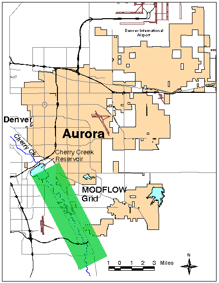
The Cherry Creek model consisted of a 72 column by 244 row grid of 200 foot squares and was oriented in a southeast to northwest manner along the axis of Cherry Creek, upstream of Cherry Creek Reservoir. Figure 1 shows the model grid in relation to the City of Aurora. Due to limited nature of this paper, detail description of the model parameters is not covered, however, more information can be obtained from the City of Aurora.
Additional GIS layers were used for reference purposes only. The line stream layer in the study area was developed from 1:24,000 scale USGS DLG data. Other GIS layers such as streets were developed by the City of Aurora's Public Works Department as part of the City's base map.
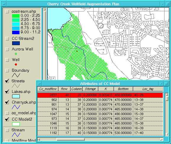
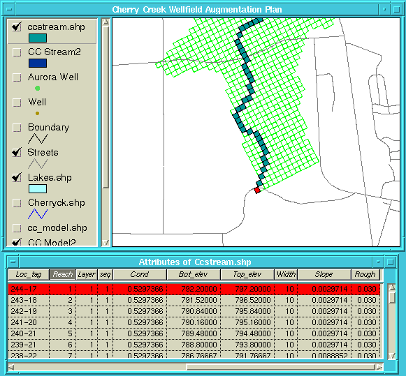
In order to display and evaluate MODFLOW simulations using ArcView additional attributes had to be added to the well, stream and MODFLOW attribute tables. A relate field called "Loc-Tag" was added to all coverages, as well as most database tables. The Loc-Tag field is simply a character string consisting of MODFLOW row and column number separated by a "-". Figure 2 shows the attribute table for the model layer, note the Loc_Tag field. With Loc-Tag, model input databases and output results can be joined to the respective coverage or shape file. This relate is helpful in displaying model results, such as drawdown or head, however, fixed attributes such as bottom elevation and transmissivity can also be displayed. One of the main benefits in using the GIS with MODFLOW is that simulation results can be displayed geo-referenced, allowing topological relationships between the model and other spatial features.
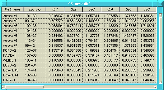
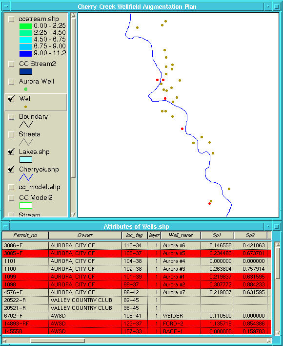
The first step in generating the WEL file was to design a database table for the well pumping data. The simple database design has one record for each well. Fields include Well_name, Loc-Tag, and Stress Period (one stress period for field). Figure 3 shows what the table looks like. Linking the well pumping table with the well attribute table using Loc-Tag as the relate field is done by the table join script ("Intable_join"). Once the tables are linked, the total number of wells to include in any simulation are selected either from the View or the attribute table. Currently, any variation in the number of wells pumping during the different stress periods has be handle via the well pumping table by using 0's for no pumping. MODFLOW will accept 0's in the WEL Package for pumping. Figure 4 displays selected wells and the joined attribute and pumping table that will be written to a text file. The WEL file generator Avenue script ("Pump_output") is activated by an icon, which will step the user through developing the WEL input file using various menus, including stress periods to be modeled and output file name. The user interface offers flexibility in allowing the pumping data to be in positive or negative values (MODFLOW treats negative discharges as pumping). The input data is justified to the MODFLOW format by calling a script called "Right_justify". The WEL input Avenue script can be found in Appendix A; in addition, a sample of the WEL input file is in Appendix B.
Output for MODFLOW simulations can either be in printed form or in binary files. Several C programs were written to read the MODFLOW binary output files and translate into ASCII test tables readable by ArcView. The C program first skips the binary file header then reads and stores the value for every cell in the time step, this is repeated for every time step in the file (Rindahl, 1996). Finally, the output file is created by first writing the header, then one line for each cell consisting of the Loc-Tag and the variable (e.g. drawdown, head elevation) values for each time step of the model run (Rindahl, 1996). Refer to Rindahl's paper (1996) for the program code.
The final process in displaying model results is handled through existing ArcView tools or through Avenue scripts. Using the Loc-Tag field in both the attribute tables and the MODFLOW ASCII output, the tables can be joined. As discussed in Rindahl's paper (1996), any model stress period result can be displayed using the legend editor of ArcView.
Several enhancements for viewing MODFLOW results were created in Avenue. One Avenue program allows the user to control the legend editor and another allows animation of time step results. Originally, these scripts were developed for ArcView 2.1, but were modified substantially for ArcView 3.0. The script controlling the legend editor allows the user to specify the increment displayed for selected time steps, then the ability to select from the color ramps available through ArcView 3.0. For example, the script creates a drawdown legend in even 0.5 foot increments. The created legend can then be saved for future use.
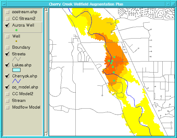
The final Avenue script converted to ArcView 3.0 is the animation of time steps program. Using the saved legend defined above, the user selects time steps to be sequentially displayed, showing a animation of drawdown fluxes, head elevation changes, or stream discharge. Several tricks in Avenue allows the animation to redraw only the aquifer portion of the display and not the entire view. Figure 7 illustrates the aquifer drawdown for Stress Period number 23 for a wet year scenario. Both scripts are included in the Appendix.
To aid in analyzing the MODFLOW model results, a ArcView 3.0 application was developed. ArcView provides a clear, geo-referenced view of the model results. By using MODFLOW coverages in a GIS, topologic anlysis can be used such as measurements, nearness and overlays. Animation and simulation of stress periods variables are possible. ArcView 3.0 provides users and decision makers with a tool assisting in groundwater management decisions.
MODFLOW was developed by Michael G. McDonald and Alren W. Harbaugh for the USGS.
Streamflow-Routing package for MODFLOW was developed by David E. Purdic for the USGS.
The particular MODFLOW model describe in this paper was developed by Bishop- Brogden and Associates, Lakewood, Colorado under contract by the City of Aurora.
McDonald, M.G. and A.W. Harbaugh, 1988. A Modular Three-Dimensional Finite- Difference Ground-Water Flow Model. Techniques of Water Resources Investigations of the U.S. Geological Survey (USGS), Book 6, Chapter A1, Denver, Colorado.
Prudic, D.E., 1989. Documentation of a Computer Program to Simulate Stream-Aquifer Relations Using a Modular, Finite-Difference, Ground-Water Flow Model. Open-File Report 88-729, U.S. Geological Survey, Carson City, Nevada.
Rindahl, B., 1996. Groundwater Modeling and Analysis Using the USGS MODFLOW Program and ArcView. Proceedings of the 16th Annual User Esri Conference, Environmental Systems Research Institute, Inc. (Esri), Redlands, California.
Van der Heijde, P. and E. Poeter, 1996. Application of the USGS MODFLOW Ground- Water Flow Simulation System. International Ground Water Modeling Center, Colorado School of Mines, Golden, Colorado.
'Right Justify Script for Input into MODFLOW
str = SELF.get(0)
len = SELF.get(1)

   for each i in 1..len
	str = " " + str
   end

return str.right(len)
'PUMP_OUTPUT.AVE
'USAGE: Creates Well input file for MODFLOW
'Written by: Cliff Inbau and Bruce Rindahl
'City of Aurora Utilities
'Lastest Update: 3/25/97

theView = av.GetActiveDoc
theTheme = theView.FindTheme("wells.shp")

'Need to Select wells for Output

theFTab = theTheme.GetFTab
thefieldlist = theFTab.GetFields
f1 = msgbox.list(thefieldlist,"Pick first Stress Period","STRESS PERIOD 1")
f2 = msgbox.list(thefieldlist,"Pick last Stress Period","LAST STRESS PERIOD")
loc_field = theFTab.FindField("loc_tag")
theFF = theFieldList.Find(f1)
theLF = theFieldList.Find(f2)
theLayer1 = theFTab.FindField("layer")
theBitMap = theFTab.GetSelection

'Specify output file name

theWFN = MsgBox.Input("Please Enter Well Input File Name For MODFLOW (with .wel
extension)","WELL FILE","c:\aview\database\well1.wel")

if (File.Exists(theWFN.asFileName)) then
   q1 = (MsgBox.LongYesNo("Do you wish to OVERWRITE file?","File Exists",false))
    if (q1 = false) then
      exit
    end
end

'Specify if Well Pumping records are positive or negitive in the input sheet
qpositive = (MsgBox.LongYesNo("Is Input Well Pumping Data Positive?","INPUT DATA",true))

'Writing to WELL FILE

lf = linefile.Make(theWFN.asFileName,#FILE_PERM_WRITE)

theTotalWell = theBitMap.Count
theTotalWell2 = av.run("Right_Justify",{theTotalWell.AsString,10})
'Query for WELCB
theWELCB = msgBox.input("Enter WELCB Unit Number, Default is 0","WELCB
INPUT","0").AsNumber
theWELCB2 = av.run("Right_Justify",{theWELCB.AsString,10})

lf.WriteElt(theTotalWell2 + theWELCB2)

for each i in theFF..theLF
  aField = thefieldlist.Get(i)
  theNumWells = theBitMap.Count
  WellNum = av.run("Right_Justify",{theNumWells.AsString,10})
  x = aField.GetAlias
  x2 = av.run("Right_Justify",{x.AsString,10})
  lf.WriteElt(WellNum + x2)

    for each r in theBitMap
       theLayer2 = theFTab.ReturnValue(theLayer1,r)
          if (theLayer2.isNULL) then
            theLayer2 = 1
          end
       l = theFTab.ReturnValue(loc_field,r)
       l2 = l.Substitute("-"," ")
       row = l2.Extract(0)
       col = l2.Extract(1)
       q = theFTab.ReturnValueNumber(aField,r)
          if ((q = 0) or (q.isNULL)) then
            q = 0
          end
          if (qpositive) then
            if ((q > 0) or (q < 0)) then
              q = -q
            end
          end
       L = av.run("Right_Justify",{theLayer2.AsString,10})
       row = av.run("Right_Justify",{row,10})
       col = av.run("Right_Justify",{col,10})
       q = av.run("Right_Justify",{q.SetFormat("d.dddddd").AsString,10})
       lf.WriteElt(L + row + col + q)
    end
end
lf.close
'STREAM_OUT
'USAGE: Creates Stream input file for MODFLOW
'Written by: Cliff Inbau and Bruce Rindahl
'City of Aurora Utilities
'Lastest Update: 4/8/97

theView = av.GetActiveDoc

'Setting Theme Variables

theThemes = theView.GetActiveThemes
theFTab = theThemes.Get(0).GetFTab

theFTabList = theFTab.GetFields
reach = theFTab.FindField("reach")
theLayer = theFTab.FindField("layer")
seq = theFTab.FindField("seq")
cond = theFTab.FindField("cond")
bot_elev = theFTab.FindField("bot_elev")
top_elev = theFTab.FindField("top_elev")
width = theFTab.FindField("width")
slope = theFTab.FindField("slope")
rough = theFTab.FindField("rough")
row = theFTab.FindField("row")
col = theFTab.FindField("column")

'Setting Tables Variables

theTBLS = FileDialog.show("*.dbf","DBF Tables (*.dbf)","Select Streamflow File")
theVTab = VTab.Make(theTBLS,false,false)
hydroField = theVTab.FindField("h_type")
hydroList = {"WET","AVG","DRY"}
h_choice = msgBox.ChoiceAsString(hydroList,"Please select hydrologic runoff type","RUNOFF
SELECTION")
q_string = hydroField.AsString ++ "=" ++ h_choice.AsString

theVTab.SetDefinition(q_string)
theVTab.UpdateSelection
av.GetProject.SetModified(true)

theFieldList = theVTab.GetFields
f1 = msgbox.list(theFieldList,"Pick first Stress Period (SP)","STRESS PERIOD 1")
f2 = msgbox.list(theFieldList,"Pick last Stress Period (SP)","LAST STRESS PERIOD")
theFF = theFieldList.Find(f1)
theLF = theFieldList.Find(f2)

for each r in theVTab
  if(theVTab.ReturnValue(hydroField,r) = h_choice) then
    theRec = r.clone
  end
end

'Specify output file name

theSFN = MsgBox.Input("Please Enter Stream Input File Name For MODFLOW (with .str
extension)","STREAM FILE","c:\aview\database\stream1.str")

if (File.Exists(theSFN.asFileName)) then
   q1 = (MsgBox.LongYesNo("Do you wish to OVERWRITE file?","File Exists",false))
    if (q1 = false) then
      exit
    end
end

'Writing to MODFLOW input file

lf = linefile.Make(theSFN.asFileName,#FILE_PERM_WRITE)

theBitMap = theFTab.GetSelection
bitCount = theBitMap.count
if (bitCount = 0) then
   theFTab.GetSelection.SetAll
   theFTab.UpdateSelection
   av.GetProject.SetModified(true)
end
theBitMap = theFTab.GetSelection
bitCount = theBitMap.count

'input for each simulation

MXSTRM = bitCount
MXSTRM = av.run("Right_Justify",{MXSTRM.AsString,10})
'the number of stream segments is read from attribute table of stream coverage
theMax1 = nil
for each rec in theBitMap
  theValue = theFTab.ReturnValueNumber(seq,rec)
  if (not (theValue.IsNull)) then
    if (theMax1 = nil) then
      theMax1 = theValue
    else
      theMax1 = theMax1 max theValue
    end
  end
end

NSS = av.run("Right_Justify",{theMax1.AsString,10})
NTRIB = msgBox.input("Enter Number of Tributary Segments that Can Be Join During Simulation:
between 0 and 10","NTRIB","0").AsNumber
  while ((NTRIB > 10) or (NTRIB < 0))
    msgBox.Warning("Must Input a number between 0 and 10!!!","")
    NTRIB = msgBox.input("Enter the Max number of Tributary seqments that can join during simulation
MAX <= 10","NTRIB","0").AsNumber
  end
NTRIB = av.run("Right_Justify",{NTRIB.AsString,10})

'creating input for tributary segments
if (NTRIB.AsNumber > 0) then
   Trib = Dictionary.Make(NSS.AsNumber)
      for each k in 1..NSS.AsNumber
        templist = list.make
          for each l in 1..NTRIB.AsNumber
             ITrib = msgBox.input("Input Tributary #"+l.AsString + " for Segment" + k.AsString,
	       "INPUT TRIBUTARIES","0")
             templist.Add(ITrib)
          end
        Trib.Add(k,templist)
      end
end

'contiune with input for each simulation
NDIV = msgBox.LongYesNo("Are diversions to be simulated?","NDIV",false)
  if (NDIV = TRUE) then
    NDIV = 1
  else
    NDIV = 0
  end
NDIV = av.run("Right_Justify",{NDIV.AsString,10})
ICALC = msgBox.LongYesNo("Are stream stages to be simulated?","ICALC",true)
  if (ICALC = TRUE) then
    ICALC = 1
  else
    ICALC = 0
  end
ICALC2 = av.run("Right_Justify",{ICALC.AsString,10})
flowUnits = msgBox.ChoiceAsString({"cfs","cms"},"Select Flow Units","UNITS")
CONST = 1.0
  if (flowUnits = "cfs") then
    CONST = 1.486
  end
CONST = av.run("Right_Justify",{CONST.AsString,10})
leakage = msgBox.Input("Enter Unit Number to output leakage: >0 save to disk; =0 not saved or printed;
<0 printed","Leakage Output","0").AsNumber
ISTCB1 = av.run("Right_Justify",{leakage.AsString,10})
store_stream = msgBox.Input("Enter unit number to save streamflow out of reach: > 0 to save;<= 0 not to
save","SAVE STREAMFLOW OR PRINT???","0").AsNumber
ISTCB2 = av.run("Right_Justify",{store_stream.AsString,10})

lf.WriteElt(MXSTRM + NSS + NTRIB + NDIV + ICALC2 + CONST + ISTCB1 + ISTCB2)

'input for each stress period
ITMP = MXSTRM
input_print = msgBox.LongYesNo("Supress Printing of Input Data Set for each Stress Period?","INPUT
PRINTING",true)
  IRDFLG = 1
    if (input_print) then
       IRDFLG = 0
    end
result_print = msgBox.LongYesNo("Supress Printing of Stress Period Results?","RESULT
PRINTING",false)
  IPTFLG = 0
    if (result_print) then
       IPTFLG = 1
    end
'ISTCB2 = av.run("Right_Justify",{store_stream.AsString,10})
IRDFLG = av.run("Right_Justify",{IRDFLG.AsString,10})
IPTFLG = av.run("Right_Justify",{IPTFLG.AsString,10})

'indexing stream attribute table
order = Dictionary.Make(bitCount + 2)

MaxReach = {}
for each i in 1..NSS.AsNumber
  MaxReach.Add(0)
end

for each r in theBitMap
  segment = theFTab.ReturnValueNumber(seq,r)
  rech = theFTab.ReturnValueNumber(reach,r)
  if ( MaxReach.Get(segment-1) < rech) then
    MaxReach.Set(segment-1,rech)
  end
  order.Add(segment.AsString+"-"+rech.AsString,r.clone)
end

for each i in theFF..theLF

  lf.WriteElt(ITMP + IRDFLG + IPTFLG)

  for each j in 1..NSS.AsNumber
    for each k in 1..MaxReach.Get(j-1)
      r = order.Get(j.AsString + "-" + k.AsString)
      theLayer2 = theFTab.ReturnValue(theLayer,r)
      theRow2 = theFTab.ReturnValue(row,r)
      theCol2 = theFTab.ReturnValue(col,r)
      theSeq2 = theFTab.ReturnValue(seq,r)
      theReach2 = theFTab.ReturnValue(reach,r)
        if (theReach2 = 1) then
           q = theVTab.ReturnValueNumber(theFieldList.Get(i),theRec).SetFormat("d.dddddd")
        else
           q = 0
        end
      theStage = 0
      theCond2 = theFTab.ReturnValue(cond,r).SetFormat("d.ddddddd")
      bot_elev2 = theFTab.ReturnValue(bot_elev,r).SetFormat("d.dd")
      top_elev2 = theFTab.ReturnValue(top_elev,r).SetFormat("d.dd")
      theLayer2 = av.run("Right_Justify",{theLayer2.AsString,5})
      theRow2 = av.run("Right_Justify",{theRow2.AsString,5})
      theCol2 = av.run("Right_Justify",{theCol2.AsString,5})
      theSeq2 = av.run("Right_Justify",{theSeq2.AsString,5})
      theReach2 = av.run("Right_Justify",{theReach2.AsString,5})
      q = av.run("Right_Justify",{q.AsString,15})
      theStage = av.run("Right_Justify",{theStage.AsString,10})
      theCond2 = av.run("Right_Justify",{theCond2.AsString,10})
      bot_elev2 = av.run("Right_Justify",{bot_elev2.AsString,10})
      top_elev2 = av.run("Right_Justify",{top_elev2.AsString,10})

      lf.WriteElt(theLayer2 + theRow2 + theCol2 + theSeq2 + theReach2 + q + theStage + theCond2 + bot_elev2 + top_elv2)
    end
  end

  if (ICALC = 1) then
    for each j in 1..NSS.AsNumber
      for each k in 1..MaxReach.Get(j-1)
         r = order.Get(j.AsString + "-" + k.AsString)
         width2 = theFTab.ReturnValue(width,r)
         slope2 = theFTab.ReturnValue(slope,r).SetFormat("d.ddddddd")
         rough2 = theFTab.ReturnValue(rough,r).SetFormat("d.ddd")
         width2 = av.run("Right_Justify",{width2.AsString,10})
         slope2 = av.run("Right_Justify",{slope2.AsString,10})
         rough2 = av.run("Right_Justify",{rough2.AsString,10})
         lf.WriteElt(width2 + slope2 + rough2)
      end
    end
  end
  if (NTRIB.AsNumber > 0) then
    for each m in 1..NSS.AsNumber
       TEMP = ""
          for each n in 1..NTRIB.AsNumber
           TEMP = TEMP + av.run("Right_Justify",{TRIB.Get(m).Get(n-1),5})
          end
          lf.WriteElt(TEMP)
    end
  end
end

lf.Close
'INTERVAL.AVE
'USAGE: Creates legend and ramps colors
'Written by: Cliff Inbau and Bruce Rindahl
'City of Aurora Utilities
'Lastest Update: 4/8/97

if(av.GetActiveDoc.GetActiveThemes.Count > 1) then
  MsgBox.Info("Select only one Theme!","ERROR")
  return -1
end
theTheme = av.GetActiveDoc.GetActiveThemes.Get(0)
aLegend = theTheme.GetLegend
theFTab = theTheme.GetFtab
theField = MsgBox.List(theFTab.GetFields,"Select the Field","Legend")

aLegend.Interval(theTheme,theField.AsString,4)

cList = aLegend.GetClassifications
MaxValue = cList.Get(3).ReturnMaximum
MinValue = cList.Get(0).ReturnMinimum
Int = MsgBox.Input("Input the Interval Value" + nl + "Range : " + MinValue.AsString ++"-"++
         MaxValue.AsString,"Interval","").AsNumber
num = ((MaxValue - MinValue)/Int).Floor + 2
if(num > 64) then
  MsgBox.Info("Too Many Classifications","ERROR")
  return -1
end
aLegend.Interval(theTheme,theField.AsString,num)
cList = aLegend.GetClassifications
x = (MinValue / Int).Floor * Int
if(x <= MinValue) then
  x = x + Int
end
for each i in 0..(cList.Count-1)
  aLegend.GetClassifications.Get(i).SetMinimum(x - Int)
  aLegend.GetClassifications.Get(i).SetMaximum(x)
  aLegend.GetClassifications.Get(i).SetLabel((x - Int).SetFormat("d.dd").AsString ++ "-" ++
        (x).SetFormat("d.dd").AsString)
  x = x + Int
end
sList = aLegend.GetSymbols
for each i in 0..(sList.Count-1)
  aLegend.GetSymbols.Get(i).SetOutlined(FALSE)
end
rampList = SymbolList.GetPredefined(#SYMLIST_TYPE_COLORRAMP)
theRamp = MsgBox.Choice(rampList,"Please Select a Color Ramp","COLOR RAM")
aLegend.GetSymbols.RampSavedColors(theRamp)
theTheme.UpdateLegend
'Cycle_leg.AVE
'USAGE: Cycles legend
'Written by: Bruce Rindahl and Cliff Inbau
'City of Aurora Utilities
'Lastest Update: 4/14/97

theView = av.GetActiveDoc

choice1 = msgBox.YesNo("Do you wish to animate the stream?","CHOICE",False)
if (choice1 = false) then

 'MODFLOW Model Grid Objects
 theTheme = theView.FindTheme("cc_model.shp")
 theTName = theTheme.GetName
 aLegend = theTheme.GetLegend
 theFTab = theTheme.GetFtab
 aList = theFTab.GetFields

 'Selecting Fields (Stress Periods) to Animate
 aField = MsgBox.List(aList,"Select the First Field","Legend")
 theFF = aList.Find(aField)
 aField = MsgBox.List(aList,"Select the Last Field","Legend")
 theLF = aList.Find(aField)

 for each i in theFF..theLF
   newField = alist.Get(i)
   aLegend.SetFieldNames({newField})
   aLegend.Load("C:\aview\legends\drawd.avl".asFileName,#LEGEND_LOADTYPE_SYMBOLS)
   aSymbol = Symbol.Make(#SYMBOL_FILL)
   aSymbol.SetColor(Color.GetWhite)
   aSymbol.SetOutlined(FALSE)
   aLegend.SetNullSymbol(aSymbol)

   theTheme.SetName(aList.Get(i).GetAlias)
   theTheme.SetVisible(False)
   theTheme.UpdateLegend
   theTheme.SetVisible(True)
   theView.Draw(theView.GetDisplay)
 end
 theTheme.SetName(theTName)

else

'MODFLOW Model Grid Objects
 theTheme = theView.FindTheme("cc_model.shp")
 theTName = theTheme.GetName
 aLegend = theTheme.GetLegend
 theFTab = theTheme.GetFtab
 aList = theFTab.GetFields

 'MODFLOW Stream Objects
 theTheme2 = theView.FindTheme("ccstream.shp")
 theTName2 = theTheme2.GetName
 aLegend2 = theTheme2.GetLegend
 theFTab2 = theTheme2.GetFtab
 aList2 = theFTab2.GetFields

 'Selecting Fields (Stress Periods) to Animate
 aField = MsgBox.List(aList,"Select the First Field","Legend")
 theFF = aList.Find(aField)
 aField = MsgBox.List(aList,"Select the Last Field","Legend")
 theLF = aList.Find(aField)

 for each i in theFF..theLF
   newField = alist.Get(i)
   aLegend.SetFieldNames({newField})
   temp = theFTab2.FindField(newField.GetAlias)
   aLegend2.SetFieldNames({temp})
   aLegend.Load("C:\aview\legends\drawd.avl".asFileName,#LEGEND_LOADTYPE_SYMBOLS)
   aLegend2.Load("C:\aview\legends\stream.avl".asFileName,#LEGEND_LOADTYPE_SYMBOLS)
   aSymbol = Symbol.Make(#SYMBOL_FILL)
   aSymbol.SetColor(Color.GetWhite)
   aSymbol.SetOutlined(FALSE)
   aLegend.SetNullSymbol(aSymbol)
   theTheme.SetName(aList.Get(i).GetAlias)
   theTheme2.SetName(aList.Get(i).GetAlias)
   theTheme.SetVisible(False)
   theTheme2.SetVisible(False)
   theTheme.UpdateLegend
   theTheme2.UpdateLegend
   theTheme.SetVisible(True)
   theTheme2.SetVisible(True)
   theView.Draw(theView.GetDisplay)
 end
 theTheme.SetName(theTName)
 theTheme2.SetName(theTName2)
end
12         0
        12       Sp1
         1       104        38  0.000000
         1       102        38 -0.263804
         1       101        39 -0.219837
         1        99        37 -0.307772
         1        99        42 -0.219837
         1        92        45  0.000000
         1        98        45  0.000000
         1       105        41 -0.110500
         1       150        39  0.000000
         1        96        43  0.000000
         1       104        46  0.000000
         1        96        46  0.000000
        12       Sp2
         1       104        38  0.000000
         1       102        38 -0.757914
         1       101        39 -0.631595
         1        99        37 -0.884233
         1        99        42 -0.631595
         1        92        45  0.000000
         1        98        45  0.000000
         1       105        41  0.000000
         1       150        39  0.000000
         1        96        43  0.000000
         1       104        46  0.000000
         1        96        46  0.000000
                  .
            (repeated for a stress periods)
 50         1         0         0         1     1.486         0         0
        50         0         0
    1  244   17    1    1       1.000000         0 0.5297366    792.20    797.20
    1  243   18    1    2              0         0 0.5297366    791.52    796.52
    1  242   19    1    3              0         0 0.5297366    790.84    795.84
    1  241   20    1    4              0         0 0.5297366    790.16    795.16
    1  240   21    1    5              0         0 0.5297366    789.48    794.48
    1  239   21    1    6              0         0 0.5297366    788.80    793.80
    1  238   22    1    7              0         0 0.5297366    786.77    791.77
    1  237   22    1    8              0         0 0.5297366    784.73    789.73
    1  236   22    1    9              0         0 0.5297366    782.70    787.70
    1  235   22    1   10              0         0 0.5297366    780.67    785.67
    1  234   22    1   11              0         0 0.5297366    778.63    783.63
    1  233   21    1   12              0         0 0.1324342    776.60    781.60
    1  232   20    1   13              0         0 0.1324342    776.11    781.11
    1  231   20    1   14              0         0 0.1324342    775.63    780.63
    1  230   20    1   15              0         0 0.1324342    775.14    780.14
    1  229   20    1   16              0         0 0.1324342    774.66    779.66
    1  228   21    1   17              0         0 0.1324342    774.17    779.17
    1  228   22    1   18              0         0 0.1324342    773.69    778.69
    1  227   23    1   19              0         0 0.1324342    773.20    778.20
    1  227   24    1   20              0         0 0.1324342    772.45    777.45
    1  226   25    1   21              0         0 0.1324342    771.70    776.70
    1  225   25    1   22              0         0 0.1324342    770.95    775.95
    1  224   26    1   23              0         0 0.1324342    770.48    775.48
    1  223   26    1   24              0         0 0.1324342    770.00    775.00
    1  222   26    1   25              0         0 0.1324342    769.20    774.20
    1  221   26    1   26              0         0 0.1324342    768.30    773.40
    1  220   27    1   27              0         0 0.1324342    767.70    772.70
    1  219   27    1   28              0         0 0.1324342    767.00    772.00
    1  218   27    1   29              0         0 0.1324342    765.63    770.63
    1  217   27    1   30              0         0 0.1324342    764.26    769.26
    1  216   27    1   31              0         0 0.1324342    762.90    767.90
    1  215   28    1   32              0         0 0.1324342    761.53    766.53
    1  214   29    1   33              0         0 0.1324342    760.16    765.16
    1  214   30    1   34              0         0 0.1324342    758.80    763.80
    1  214   31    1   35              0         0 0.1324342    757.85    762.85
    1  214   32    1   36              0         0 0.1324342    756.90    761.90
    1  214   33    1   37              0         0 0.1324342    755.96    760.96
    1  213   34    1   38              0         0 0.1324342    755.00    760.00
    1  212   34    1   39              0         0 0.1324342    754.06    759.06
    1  211   35    1   40              0         0 0.1324342    753.11    758.11
    1  210   35    1   41              0         0 0.1324342    752.17    757.17
    1  209   36    1   42              0         0 0.1324342    751.26    756.26
    1  208   36    1   43              0         0 0.1324342    750.35    755.35
    1  207   37    1   44              0         0 0.1324342    749.45    754.45
    1  206   37    1   45              0         0 0.1324342    748.54    753.54
    1  205   38    1   46              0         0 0.1324342    746.96    751.96
    1  204   38    1   47              0         0 0.5297366    745.38    750.38
    1  203   39    1   48              0         0 0.5297366    743.80    748.80
    1  203   40    1   49              0         0 0.5297366    743.18    748.18
    1  202   40    1   50              0         0 0.5297366    742.56    747.56
        10 0.0029714     0.030
        10 0.0029714     0.030
        10 0.0029714     0.030
        10 0.0029714     0.030
        10 0.0029714     0.030
        10 0.0029714     0.030
        10 0.0088852     0.030
        10 0.0088852     0.030
        10 0.0088852     0.030
        10 0.0088852     0.030
        10 0.0088852     0.030
        10 0.0088852     0.030
        10 0.0021224     0.030
        10 0.0021224     0.030
        10 0.0021224     0.030
        10 0.0021224     0.030
        10 0.0021224     0.030
        10 0.0021224     0.030
        10 0.0021224     0.030
        10 0.0032773     0.030
        10 0.0032773     0.030
        10 0.0032773     0.030
        10 0.0032773     0.030
        10 0.0038454     0.030
        10 0.0038454     0.030
        10 0.0038454     0.030
        10 0.0038454     0.030
        10 0.0038454     0.030
        10 0.0030588     0.030
        10 0.0030588     0.030
        10 0.0030588     0.030
        10 0.0030588     0.030
        10 0.0056807     0.030
        10 0.0056807     0.030
        10 0.0056807     0.030
        10 0.0056807     0.030
        10 0.0056807     0.030
        10 0.0037871     0.030
        10 0.0037871     0.030
        10 0.0037871     0.030
        10 0.0032045     0.030
        10 0.0032045     0.030
        10 0.0032045     0.030
        10 0.0069042     0.030
        10 0.0069042     0.030
        10 0.0069042     0.030
        10 0.0069042     0.030
        10 0.0069042     0.030
        10 0.0027092     0.030
        10 0.0027092     0.030
        10 0.0027092     0.030
        10 0.0027092     0.030
        10 0.0027726     0.030
        10 0.0041365     0.030
        10 0.0041365     0.030
    (repeated for all stress periods)
Cliff Inbau, Water Resource Engineer (Primary and Presenting Author)
Bruce Rindahl, Senior Water Resource Engineer (co-author)
City of Aurora, Utilities Department
1450 South Havana Street, Suite 232
Aurora, CO  80012

Phone:  (303) 739-7384
Fax:  (303) 739-7604
E-mail:  cinbau@dilbert.ci.aurora.co.us