James R. Oakleaf and Wendy L. Berelson
Development and economic pressures in Wyoming and throughout the Rocky Mountain region have directly contributed to the continual disappearance of the family owned and operated ranch or farm. Not only are generations of a "way of life" being lost, but many times these agricultural lands/open spaces are converted to residential housing of varying densities. Due to the ecological importance and intrinsic value of these lands, several different organizations and government agencies have employed an assortment of techniques to slow this trend. The most common of methods include public land use planning (e.g. zoning, subdivision regulations), conservation easements, and/or land acquisitions. Many times these approaches are impractical, unfeasible, and/or greatly restrict the future ranching/farming practices of a landowner. One avenue currently being explored by Wyoming Open Lands (WOL) is the use of legally binding private land use plans. This type of planning allows for all landowners within an area of mutual interest (AMI) to equally be involved in the negotiating and development process by addressing and incorporating the concerns of the collective group into their plan. In order to facilitate these efforts, the Spatial Data & Visualization Center (SDVC) at the University of Wyoming in cooperation with WOL has created and designed a geographic information system (GIS) to be used as a tool throughout all phases of the process. This system, with a minimal number of base data layers, uses customized ArcView applications in conjunction with the Spatial Analyst extension to produce a landowner derived land use preference maps to facilitate the planning process.
1.0 INTRODUCTION
The state of Wyoming has the sixth highest percentage of land in public ownership throughout the United States with over 55,000 sq. miles of land being managed by federal & state agencies (State of Wyoming 1996). These public lands are extremely diverse ecologically and physiologically, ranging from vast open grass/sagebrush plains to more extreme rock and ice mountain features. Some of the most vital regions found in the state however are the lowland valley riparian areas. These regions contain the most diverse flora and fauna and are usually privately owned (Merrill et al. 1996). If managed correctly, these lands provide a economic livelihood for many Wyomingites while at the same time provide an assortment of natural amenities (ie. abundant wildlife, clean air and water, open spaces, and/or picturesque viewsheds).
In recent years with the explosion of second homes, increases in population and land values, and a steady decline in cattle prices (State of Wyoming 1996), many of these vast Wyoming ranch or farmlands are being sold to the highest bidder. This phenomenon, seen throughout the west, results in a reoccurring theme many landowners face: how to survive being land rich and cash poor. Survival, not wealth and riches, are causing land sales. Families are not only loosing a "way of life" generations old, but many times the end result is a large ranch being converted into several smaller "ranchettes".
Although selling land is a personal decision, several methods have been employed in Wyoming and other states to limit the fragmentation that many times follows a transaction. Counties can use public land use plans to limit the density of houses and/or type of structures that are developed. Several different non-governmental land trusts provide easement opportunities for conservation purposes and/or provide tax incentives. Finally, federal, state, or local agencies can directly purchase land for preservation. In Wyoming, where planning is often a "four-letter word", many landowners are apprehensive about getting involved with national land trusts, and federal and state agencies are run with tight budgetary constraints. This results in little or no protection being provided to preserve Wyoming agricultural lands/open spaces once title has been transferred to the purchasing party.
Seeing a need to provide other mechanisms in the protection for Wyoming agricultural lands and open spaces, the agricultural land trust, Wyoming Open Lands (WOL) was created. WOL is a publicly supported non-profit corporation organized to provide statewide land trust stewardship services to Wyoming's private landowners. WOL works cooperatively with landowners, ranchers, and communities through facilitation of voluntary collaborative agreements between neighboring landowners protecting those farms, ranches, and other open lands which give Wyoming its distinctive rural, scenic, and western character. Two characteristics set WOL apart from other land trust. It is the only statewide land trust and is therefore managed to address the wide variety of issues Wyoming landowners are facing. WOL also places heavy emphasis on the role of private planning among cooperating landowners.
Private planning is a process that brings together all landowners within an area of mutual interest (AMI) with the primary goal of fostering a group decision in respect to the long term appearance and land use of the region (Geehan 1996). In this arena, landowners can collaborate with their neighbors and understand their wishes and concerns. Then through compromises and agreements, the group can create a plan for the whole area of interest instead of just managing their personal land holdings.
In the private planning process developed by WOL, each individual landowner within an AMI delineates what areas are important for protection to them and why. Additionally, areas in which they possibly foresee development on their lands are identified. Once all of these individual testimonials have been completed for all the landowners in the AMI, the group tries to come to a consensus on what areas should be protected for agricultural/open space purposes and those that are acceptable for developing. This step usually requires facilitation by an outside party (i.e. WOL) and commonly involves several iterations before an agreement can be reached. After all the areas within the AMI have been designated, a private plan is drafted and signed by the parties involved. Individual landowners are responsible for complying with the plan by applying any creditable open space protection method (e.g. an agricultural or conservation easement monitored by WOL or any viable land trust group, a charitable remainder trust, etc.) to regions within the plan designated as such on their lands. Additionally, it is the landowners responsibility to place the group-decided development restrictions (density and location) on land sales.
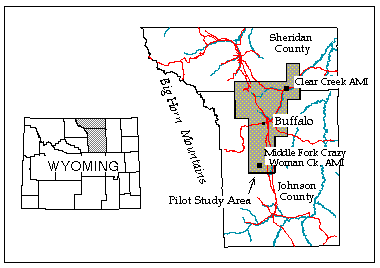
To facilitate these efforts, the Spatial Data & Visualization Center (SDVC) at the University of Wyoming in cooperation with WOL has created and designed a GIS to be used as a tool throughout all phases of the collaboration process. Data development and the customization of ArcView were the two substantial tasks necessary for completion of the GIS. Project efforts focused on a pilot study area located on the eastern slope of the Bighorn Mountains near Buffalo, WY containing two AMIs (Figure 1). This region of the state has witnessed a gradual increase in new landowners and has provided an opportune environment to develop and refine the private planning process and the implementation of GIS into this arena.
2.0 METHODOLOGY
Due to the unique nature of incorporating GIS into the private planning process and WOL's lack of familiarity with GIS, it became vital to establish a format in which to follow during the development process. Although the utilization of GIS for this project had already been decided, the framework of developing, designing, and implementing the system followed an adapted subcomponent of the GIS acquisition model (Clarke 1991). This model has four major stages; analysis of requirements, specification of requirements, evaluation of alternatives, and implementation of the system (Clarke 1991). Each of these stages has several sub-tasks associated with the completion of that stage. For implementing GIS in the private planning process, the first stage, analysis of requirements, was modified and applied during the development of the system. The sub-tasks followed during the GIS implementation were: (1) definition of objectives, (2) user requirements analysis, (3) preliminary design, (4) pilot study, and (5) cost-benefit analysis.
3.1 Definition of Objectives
The overall goal of this project was to design a GIS to facilitate the private planning process specific to the needs of both landowners and WOL. In order to accomplish this goal, three major objectives had to be completed. First, data development costs had to be kept to a minimum while still allowing for landowners to visually recognize features relating to their land and others. Second, graphical user interfaces needed to be developed and tailored to the three phases of the planning process: (1) landowner preference designation, (2) landowner collaboration, and (3) data storage and updates. The last objective was to design all the interfaces so that "non-technical" GIS personnel could use the tool. This allows landowners to have a "hands-on" approach to the use of GIS and at the same time raise their interest in the private planning process.
3.2 User Requirement Analysis
This analysis can be broken into two parts, who are the users and what data are necessary. The most obvious users, and who the whole system is designed for, are the landowners. Without their interest and involvement in the process, the ability of producing private plans is unattainable. Another critical user is the WOL facilitator, since this person must effectively utilize the tool during the collaboration process. Many times in order to reach an agreement between landowners the negotiation process may require several iterations, therefore making it necessary to input or alter preference designations, display the modified land use plan, and document all changes. This requires that the facilitator be more familiar with all the applications at their disposal and also dictates that the interface developed for this phase be more complex. Finally, the last of the immediate users are the GIS Analyst/programmers, who will develop additional data requests and customize the tool.
After considerable "brainstorming" efforts among an assortment of the aforementioned users, six initial base data themes were deemed necessary for landowners to reference features found in an AMI; hydrography, roads, public land survey system (PLSS), land ownership, aerial photos, and homesites. After examining the required accuracy and available digital data, it became necessary to digitize both hydrography and land ownership layers from USGS 1:24,000 quadrangles and county assessor's maps, respectively. The statewide roads and PLSS data layers that had been previously developed at the University of Wyoming were considered acceptable for use. Black-and-white National Aerial Photography Program (NAPP) 1:40,000 photo positives were scanned and geo-referenced. Finally, homesites were screen digitized from the aerial photos. From these layers landowners could recognize enough features to reliably delineate and place their protection preferences into the system. Additionally, to further describe each AMI, randomly distributed digital landscape photographs were "hotlinked" to corresponding georeferenced points throughout the area.
3.3 Preliminary Design
As previously mentioned three separate customized ArcView interfaces were developed using Avenue (ArcView's object-oriented programming language) for this project. Each application was applied to a distinct phase of private planning: (1) inputting landowner preferences, (2) facilitating private planning among the parties, and (3) data storage and individual landowner obligations. Additionally, the Spatial Analyst extension played a substantial role in data developed during the use of these interfaces. The actual utilization of these interfaces has been limited to the first phase of the process (landowner preference designation). The other two are in the preliminary stage awaiting to be applied and tested.
The first interface required limited user input functionality but extensive data processing. Landowners had to be able to locate their land and recognize features throughout the AMI during the preference delineation process. This required a simple "find-and-display" menu which identified their lands and centered the AMI view around those lands. All other menus, buttons, and tools were directed toward inputting and attributing landowner preferences. Using GIS, each landowner entered polygons associated with areas they felt were highly important to preserve the status quo of the AMI (high protection), would like to see preserved (moderate protection), and areas in which they foresee development occurring on their lands (Figure 2). Additionally, reasons or comments associated with these designations were tied to each area (e.g. viewshed, riparian protection, development density, etc.).
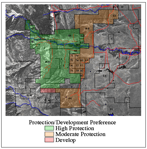
Once a landowner completed their session, preference data were automatically transferred to a specific landowner account and to a master AMI preference account. The master account has two grids, the protection status and development scenario. For the protection status grid, each individual landowner protection grids were summed together with a high status given a value attribute of two and moderate that of one. This produced a grid which had a range of values grouped into two class; those above the midpoint (high preference) and those below (moderate preference). "No data" values constituted areas in which landowners felt protection was unnecessary. For displaying the overall AMI development possibilities, individual landowner development grids were also combined.
With all of the landowners having placed their preferences in the system, the second phase of private planning begins: negotiation or facilitating. Not all landowners within an AMI are going to agree on protection scenario of the plan and thus, discussions among the group is necessary. This is where the second ArcView interface plays a significant role. First it displays and/or produces a map which overlays the two master AMI preferences, development and protection (Figure 3). In order to differentiate between high and low conflict areas a matrix was developed (see legend of Figure 3). Areas in red or green do not require collaboration due to a lack of conflict, however yellow and orange provide a focus for the facilitator. Discussion among the group hopefully leads to modifications or changes to eventually alleviate the conflicting regions. Each alteration is placed into the system by the facilitator and a new AMI preference map is produced. Once a group agreement or compromise is reached, the density of development and protection methods can be examined.
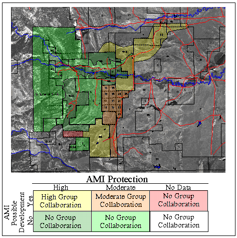
For conflicting areas in which the collaboration process has been stalled, additional data layers may be needed to influence individuals (e.g. slope, regions buffered from streams, areas within a distance of existing roads, viewsheds, etc.). If group consensus still can not be reached, the process allows for tradable commitments to be arranged between conflicting parties. These commitments are tangible actions performed by a landowner in order for their neighbor not to perform an action. Therefore, it is vital that this interface not only provide the tools necessary to make changes during the facilitating process but also document all changes, added data requests, and tradable commitments.
In anticipation of developing several private plans throughout the state of Wyoming, the last interface is designed to allow for data retrieval, updating, and monitoring of these agreed upon protection/development scenarios. Methods employed by the parties (e.g. development density, open space protection, easements, etc.) will be placed within the database. This assists WOL in monitoring compliance of the private plan and reassures neighboring landowners that all the parties are participating. Additionally, each AMI that has adopted a private plan will be "hotlinked" to that document.
3.4 Pilot Study
Currently, data development at the SDVC has occurred for one study area which incorporates two AMIs, Crazy Woman Creek and Clear Creek (Figure 1). The actual adoption of a private plan and utilization of GIS in this process has been accomplished on the Crazy Woman Creek. Creation of the ArcView applications is still an ongoing process being modeled after this AMI work. Preliminary customized interfaces were developed and tested throughout the initial landowner preference designation, however due to a group consensus to not develop any land within the AMI, the facilitating tool could not be applied. Clear Creek is already proving to be a different situation and appears to provide the varying preferences that will be required to test the facilitating application. Once both AMIs have completed the private planning process, comments and suggestions by the landowners and facilitator concerning the functionality and "ease-of-use" of the GIS, will be addressed. This could potentially lead to substantial modifications to the system design and many require further testing on another AMI within the pilot study area.
3.5 Cost-benefit Analysis
Since the project is still in the pilot study phase, this step has yet to be truly addressed. There are, however, issues that have already arisen that will require study during this task. The most significant factor will likely be the cost to not only develop but maintain the data at the WOL office. By teaming with the SDVC at the University of Wyoming, the tools necessary to create the digital data for this project were provided. In order for WOL to repeat this process in other regions across the state, they will have to either invest the moneys necessary to digitize data and scan aerial photos or look at third party agreements. This lack of large scale digital data is a common theme across Wyoming and will require data development where ever WOL initiates the private planning process.
One benefit that already has been realized from implementing GIS is the willingness of landowners to participate hightens when they have a chance to use "modern technology". Many landowners have heard the term GIS but do not fully understand the ability of today's systems. After seeing their own land and being able to recognize land features associated to their AMI, GIS takes on a new meaning. Suddenly people that may not have ever touched a computer want to "play" with the software. This translates into individual landowners having a greater involvement in the development of both the GIS and the private plan. Additionally, by allowing individuals to input preferences without being in a "group environment" the GIS limits outside influences and truly represents each landowner's preference.
4.0 CONCLUSION
As GIS and the customized applications are applied in the private planning process for other regions across the state of Wyoming, the actual development of the system will continue to evolve. There are a number of improvements that could enhance the GIS tool. Additional functionality and data layers may be incorporated during the facilitating process in order to have more dynamic collaboration among landowners. Items like viewshed and buffer analysis could be done by a "push of the button" while everyone is at the table instead of having to reconvene once the data is produced by a GIS analyst. Future work could also utilize visualization techniques. This may be an actual video display of the present condition of the AMI and/or simulated views of the projected development scenarios. Finally, the system could be incorporated to create private plans for even larger land areas and landowners.
A successful implementation of GIS into the private planning process will not guarantee that the overall idea fostered by WOL will be achieved. GIS is just one tool, that if used correctly, can aid the private planning process. The real key will be in the willingness of both WOL and landowners to work together to preserve Wyoming's agricultural "way-of-life" while at the same time maintaining the vast open lands that make this state unique.
5.0 ACKNOWLEDGMENTS
This project has been carried out with funding from the University of Wyoming Spatial Data and Visualization Center (SDVC), a program under the Wyoming National Science Foundation (NSF) Experimental Program for the Stimulation of Competitive Research (EPSCoR) with matching funds from the Wyoming Science, Technology and Energy Authority (STEA), and Wyoming Open Lands (WOL). The authors wish to thank all of these organizations for their support.
6.0 REFERENCES
Clarke, A. L. 1991. GIS Specification, Evaluation, and Implementation. In: Maquire, D. J., M. F. Goodchild and D. W. Rhind. (eds.). Geographic Information Systems: principles and applications. Longman, London. pp. 403-412, vol. 1.
Geehan, N. O. 1996. Personal Communication.
Merrill, E. H., T. W. Kohley, M. E. Herdendorf, W. A. Reiners, K. L. Driese, R. W. Marrs, S. H. Anderson. 1996. Wyoming Gap Analysis: a geographic analysis of biodiversity. Final Report, WY. Coop. Fish Wildl. Unit, Univ. WY., Laramie, WY.
State of Wyoming. 1996. Equality State Almanac: State of Wyoming. In: Callaghan, P. and S. Lamb (eds.). Department of Administration and Information and Division of Economic Analysis, Cheyenne, Wyoming. 4th Edition.
7.0 AUTHOR INFORMATION
James R. Oakleaf
Wendy L. Berelson