
Figure 1: The CATS Concept
Included amongst the many things changed by the end of the Cold War era, was the increased priority that military forces would respond to missions involving support to civil authorities, humanitarian assistance, and peacekeeping. To this end, traditional war-time mission planning tools were modified to address a broad set of applications usable by military and civil emergency managers.
The result is a new system that combines damage prediction models and databases in the Esri ArcInfo Geographic Information System to allow a broad range of consequence assessments for a diversity of natural and technological disasters. This computer system, known as the CONSEQUENCES ASSESSMENT TOOL SET (CATS), is easily usable by emergency response staff, operates in real time, and is only limited by the availability of infrastructure, population, resource, and facility databases.
CATS currently can be used for earthquakes, hurricanes, storm surge, and radiological, chemical, and biological releases. The CATS system capabilities include: Hazard/Damage area estimates, contingency planning, assessment of consequences, logistics plans/reports, and response training. CATS is currently operational at numerous Department of Defense sites, the Federal Emergency Management Agency, and several State Emergency Management Agencies/National Guard units.
The lack of a consequence management capability for damage estimation and relief resource planning became obvious after Hurricane Andrew struck Dade County Florida in August 1992. The ineffective and inefficient Federal response prompted Senator Barbara Mikulski to request a federal level review to ... "recommend the optimal manner in which the Federal Government should preposition the necessary supplies, materials, and people for rapid deployment soon after disaster strikes." In response, the Defense Special Weapons Agency (DSWA) (known at that time as the Defense Nuclear Agency) and the Federal Emergency Management Agency (FEMA) instituted a joint program to adapt Department of Defense technology to the broad gamut of natural and technological disasters.
The result of their efforts is a new computer system that combines damage prediction models and databases within the Esri ArcInfo Geographic Information System (GIS) to allow a broad range of consequence assessments. This system, the CONSEQUENCES ASSESSMENT TOOL SET (CATS) enables emergency managers at all levels to effectively responds to the following disasters:
CATS has been designed to be extremely user friendly relying extensively on intuitive operations. This approach has been stressed since most emergency support personnel will not have consistent application of the system. Another important design application was the need for immediate real time answers, i.e., customized reports and graphics, to the emergency managers.
CATS system capabilities include: Hazard/Damage area estimates; identification of population, infrastructure, facilities, and resources at risk; and automated customized reports and graphics. In addition, CATS has been linked to NOAA meteorological satellites carrying the Advanced Very-High-Resolution Radiometry (AVHRR) IR and visual sensor suite for the detection and location of fires and for determination of flood extents.

Because of its broad capability, CATS has been used to support emergency managers for every hurricane since August 1993; the Midwest floods of 1993; fires in California, New York; and the Northridge earthquake.
In addition, CATS has been extensively used for training exercises and operations. These applications have included Response 95 (Hurricane Jennifer), Makani Pahili, Central U.S. Earthquake Consortium, Operation Ill Wind, and numerous State exercises. CATS has recently supported many Department of Defense operations including the USMC Chemical Biological Incident Response Force and the Atlanta Olympics.
The CATS computer system has been widely deployed and is operational at Pacific Command, the Pacific Disaster Center, Forces Command, DSWA, FEMA, and Army National Guard units supporting State EOCs. In the immediate future, CATS will be installed in the Joint Chiefs of Staff and the Directorate of Military Support.
At the heart of the consequence analysis is the GIS. The GIS is a framework for representing and manipulating all of the various system components. Specifically, the GIS for the CATS needed to have the capability to geo-reference hundreds of gigabytes-worth of data on the US and world-wide infrastructure (population, terrain, roads, businesses, emergency services, utilities, pipelines, electrical lines, etc.), flexibly access the various formats of on-site data collection, e.g., inspection reports and photographs, be commercially available to all anticipated US users, be able to conduct "roll-up" assessments of the damage model outputs intersected with the infrastructure databases, and operate on a workstation-level computer.
The system selected was ArcInfo GIS by Esri. This commercially available GIS has met all the requirements of the CATS system and has the advantage of being maintained by a commercial vendor in a competitive market that ensures excellent quality and state-of-the-art capabilities through periodic upgrades co. Additionally, there is a considerable number of commercially available databases compatible with the ArcInfo GIS. Thus, many of the supporting databases can also be commercially procured. For the CATS application, there have been some specialized databases that are not generally available and that have required manual translations into the ArcInfo format. Fortunately many databases do not fall into this category and the process of incorporation, while labor intensive, is relatively quick.
CATS operates on SUN and IBM UNIX work stations. It requires licenses for archive, Version 2.1 or later, and ArcInfo, Version 7.0.3 or later with GRID option, and approximately 5 gigabytes of disk space to accommodate the entire software package, including a reasonable amount of geographic, population and other infrastructure data. It is anticipated CATS will become PC-based in the near future, as a standalone system and in a client-server architecture.
CATS' Hurricane Wind Module is capable of estimating the population and civil resources at risk from threatening hurricanes, and CATS' Hurricane Tracking Module makes it possible for emergency managers to prepare their relief efforts before the hurricanes arrive.
CATS' hurricane modules use maritime advisory messages from the National Hurricane Center, transmitted via the National Weather Service's Family of Services, to obtain the current and forecast positions and strength of tropical storms. Using the information provided by these messages, the hurricane modules generate complete wind profiles (wind speed vs. distance from storm center) for the storm's current and forecast positions, and adjusts the profiles such that the gust velocity represents the maximum wind speed. The module then converts these wind profiles to dynamic pressure.
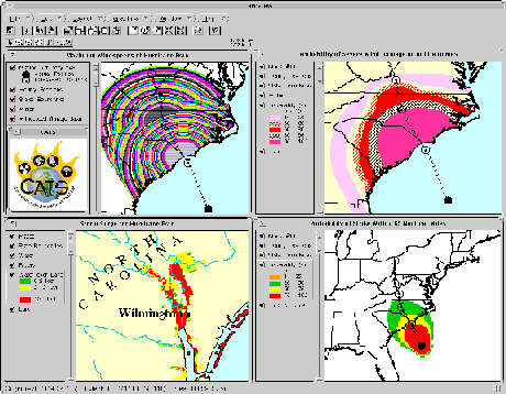
Dynamic pressure is correlated to light, moderate, and severe levels of expected and probabilistic damage, and is defined in terms of structural response modeling. For every structure type, the hurricane module illustrates which geographic areas can expect what levels of expected and probabilistic damage. After drawing damage bands wherever the current and forecast dynamic pressure of the storm is within the defined damage ranges, the hurricane wind module can then use its GIS capabilities to estimate the number of people and critical resources located within the effected areas.
Further, knowing the number of people and critical resources in the effected area, CATS can then calculate the amount of relief support needed, including the required number of meals, tents, cots, blankets, bottles of water, toilets, and other essential supplies.
The hurricane wind module became operational on June 1, 1993, and proved to be completely functional for emergency managers responding to Hurricane Emily. Illustrations of the work performed by CATS were shown to the President of the United States during the briefings which took place while Hurricane Emily was still threatening. Relief supply needs were calculated before landfall, and by the time Emily arrived, the supplies were ready for distribution. In the end, CATS' estimates of damage to residences proved to be acceptably close to published damage assessments.
CATS' Storm Surge Model is an adaptation of the National Weather Services Maximum Extent of Water (MEOW) database. The model predicts the height-of-water over land due to the threatening hurricane. This estimation is accomplished by combing the NWT MEOW database which indicates the height-of-water above mean sea level as a function of the hurricane's speed, intensity and direction with the United States Geological Survey (USG) Digital Elevation Model.
During the 1995 Atlantic Hurricane season, the busiest on record, CATS kept pace with all the hurricanes the Atlantic could brew. Proving its capabilities once again with Marlin and Opal, CATS' accuracy in assessing structural damage was a key factor in the prompt dispatch of sufficient relief supplies. And during Hurricane Fan in September 1996, CATS' assessments proved so effective, that the Major General of Camp LEJEUNE U. S. Marine Corps Base awarded high praise to CATS technicians who "contributed significantly to Marine Corps Base Operation Center (MOBCAP) efforts to protect the health, safety and general welfare of the residents and personnel of Camp LEJEUNE."
Experience in the United States has shown that because of broken lines of communication, it is difficult to obtain an immediate estimate of earthquake damage. In an effort to provide one, CATS has incorporated an earthquake model developed by the USG.
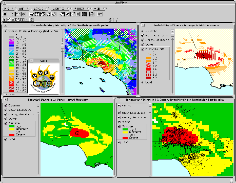
The earthquake model requires a minimum of information in order to run: the location of the earthquake's epicenter, its magnitude, the geometry of the fault rupture, and the surface geology where the earthquake struck (provided in the form of a digital geological database). CATS' user interface automatically inputs this information from the USG Interment site and digitized fault lines. When the model output is merged with the resource, population, and housing databases in the GIS, emergency managers can quickly estimate the extent of expected and probabilistic damage, and anticipate the requirements for relief.
In January 1994, on the morning of the earthquake in the Northridge section of Los Angeles, FEMA and DNA used CATS to assess the extent of the damage. CATS' earthquake module, using bulletins issued by the USG National Earthquake Information Center in Boulder, Colorado, calculated the Modified Mercalli Intensity (MMI) of the earthquake ground shaking throughout the affected area. The MMI shaking intensities, like the dynamic pressures of a hurricane, are associated with various levels of damage, and the earthquake module, like the hurricane winds module, constructs deterministic and probabilistic damage bands. CATS uses the GIS to determine the population and critical resources at risk in the affected areas.
What began as a wet spring in 1993 for the upper Mississippi River basin became a disaster by mid-summer. The Mississippi and Missouri Rivers and their tributaries flooded entire towns and forced thousands of families from their homes. Water ruined millions of acres of prime farmland, and severely damaged or destroyed bridges, water treatment plants, levees, and other public structures. The flooding shut down river traffic and caused serious economic disruptions, both in the public and private sector.
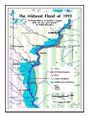
Responding to the immediate demands of the crisis, CATS provided valuable information regarding the extent of flood damage, and helped emergency managers determine how much of the population and critical resources were at risk of suffering losses. Estimates were obtained through CATS' analysis of satellite imagery from Advanced Very-High-Resolution Radiometry (AVHRR) sensor satellites set in orbit by the National Oceanic and Atmospheric Administration (NOAA). The analysis was performed using the Geographic Information System ArcInfo, which, incorporated into CATS, translates pixels from the satellite images into polygons representing the extent of the flooding. These flood polygons were in good agreement with the flood boundaries that were mapped in Illinois by the US Army Corps of Engineers using a Global Positioning System (GPS). Like the damage bands of CATS' other modules, the flood polygons determine the GIS extents for estimating the population, housing, and critical resources at risk of suffering losses from the disaster. Supported by CATS' assessment of the flooding, the President of the United States declared major disasters in nine states, which resulted in a staggering total of 533 counties eligible for assistance.
The flooding which occurred in Georgia and Florida during the following summer, and that of Texas during the Fall of 1994, further emphasized the value of CATS' assessments. As a result of CATS' application during these floods, discoveries were made which today are further enhancing CATS' flood assessment capabilities. In addition to satellite imagery, it has been determined that data from river gauge measurements could also be incorporated into CATS' analyses, providing even more reliable analyses.
CATS provides for the calculation of hazards from a variety of sources, particularly those associated with chemical, biological, and radiological releases, as employed by military forces or deliberate/accidental releases. A graphical user interface (GUI) and pre-defined event scenarios assist the CATS user in predicting credible hazards resulting from the dispersal of radiological, biological and chemical agents, regardless of the user's level of expertise and access to information.
The GUI is divided into two sections, Express and Detailed. Express input allows a user, otherwise untrained in the science of hazard assessment, to generate distributions of radiation intensities or concentrations of biological or chemical agents using predefined event types, combined with current weather information. Deliberate/accidental events include explosive dispersal of agents from large and small canisters, as well as ground and aircraft sprayers. Military events include deployment of all manner of munitions, delivering nuclear, biological and chemical warheads in credible spatial distributions.
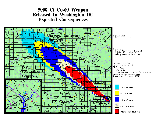
The Detailed input option allows the experienced CATS user to vary a large number of input parameters, describing munitions, agents and their manner of deployment, as well as environment variables, including multi-dimensional wind fields.
While there are other code systems available that permit the display of hazard distributions, CATS emphasizes the calculation and analysis of consequences. The technological hazard component of CATS contains models for converting hazard spatial and temporal distributions into probabilities of casualties, including both mortality and morbidity. These probabilities can be created for diverse exposure scenarios, including time-varying protective measures.
The CONSEQUENCES ASSESSMENT TOOL SET provides the emergency manager with an effective, easy-to-use means for quick response to natural and technological disasters. CATS has been installed and is operational at numerous locations at the Federal and State level and within the Department of Defense. It current capabilities are being upgraded and the software will be maintained by the Defense Special Weapons Agency and the Federal Emergency Management Agency.
Acknowledgments: This work reflects the joint efforts of the Defense Special Weapons Agency, the Federal Emergency Management Agency, and Science Applications International Corporation.
Author Information:
	Robert Kehlet	Program Manager
	Defense Special Weapons Agency
	6801 Telegraph Road
	Alexandria, VA  22310
	Telephone number: 703-325-2046
	Fax number: 703-325-2957
	e-mail:kehlet@hqg.dswa.mil