Richard A. Schreiber
The Flood Recovery Program of the Georgia Department of Human Resources Division of Public Health operates under a two-year, $3,775,000 grant (U1Q/CCU411900-01) for emergency relief and disaster preparedness as a result of the July 1994 Tropical Storm Alberto flooding in Southwest Georgia. One of the tasks to be accomplished under this grant was to provide for spatial location of features by methods other than with grant provided Global Positioning System (GPS) units. The Program developed an ArcView script application to produce XY locations for features shown in digital orhthophoto images to demonstrate the methodology for accomplishing the grant task. Using the images as a spatial referent, features are selected, given identifiers, and are stored in dbf files for joining at a later date with data describing the selected features. This paper discusses the background for the grant, grant tasks using spatial data, the drawbacks of depending on GPS for that spatial data, development of the Virtual GPS process, the benefits and drawbacks of applying this method, and the future development of the application.
In July 4 through 7 of 1994, Tropical Storm Alberto(1) moved into Southwest Georgia depositing as much as 21 inches of rain in a 24 hour period with some areas exceeding 28 inches in total accumulation. This caused sever flooding in the Flint and Ocmulgee River basins(2), and to a lesser extent in the Chattahoochee River basin. Some municipal water systems were contaminated resulting in some residents being on a boiling water restriction for as long as two weeks. The Georgia Emergency Management Agency(3) was activated resulting in the involvement of many of the State of Georgia government departments.(4)
The flooding caused by Tropical Storm Alberto created numerous threats to public health. These included contamination of private drinking water wells, damage to septic and sewage systems, disruption to municipal water supplies, and contamination of public and private housing(5). Many persons were dislocated with some only returning to the area after more than two years. The Georgia Department of Human Resources Division of Public Health applied for an Emergency Flood Relief Grant from the Centers for Disease Control and Prevention to conduct analysis of the long term public health effects that resulted from the flood and to provide for public health disaster preparedness.
The Georgia Emergency Flood Relief and Disaster Preparedness Grant became
affective August 1, 1995. The grant was for one year with a one year extension
with funding ending July 31, 1997. The grant application identified four
broad goals for the Flood recovery Program. In summary these goals can
be identified as:
This paper describes selected efforts by the Flood Recovery Program in the second grant goal.
Environmental Health activities conducted within the Albany Health District included a Private Well Water Survey to evaluate the many wells that were contamination by E. coli from tributary and surfacial flooding. There were several anecdotal reports of flood waters entering the ground through sink holes unplugged by flood waters. Flooding of the rivers and tributaries within the affected area raised concerns over the contamination of private drinking water supplies. The Department of Natural Resources Environmental Protection Division implemented a one mile boundary around the flooded tributaries within which a boiling water advisory for drinking water was issued. Sampling revealed that the extent of contamination was well outside this boundary. Many wells still show coliform contamination even after repeated disinfection by chlorination. The Private Well Water Survey was initiated to identify those factors which could be used in future floods to better define boundaries for public health advisories.
Twelve technicians were hired to conduct physical surveys of all private wells within the declared flood area and to locate them with Spectrum global position system (GPS) units purchased from the Sokkia Corporation(6). Training in the use of the GPS units was conducted by manufacturer personnel and by the author. A feature library was created to record the physical survey data while GPS reading were being taken. This data was transferred from the GPS units to desktop computers then transmitted to the district office for differential processing. A base station in Atlanta was used (base line distances between 110 miles and 215 miles) with a resulting RMS error in the vast majority of cases of less than 2 meters after processing.
After differential processing by the Sokkia software the raw GPS data was converted into dbf files containing spatial location (latitude/longitude) for the wells and attribute data from the well survey. The spatial data file contained a GPS-unit generated point number and the spatial location of the point. The attribute data was written to a dbf file with 21 records (one for each attribute) for each point. These files were then merged with a Visual dBase program to combine the survey data and spatial data for each location into a single record. There are a projected 22,000 points in this well survey.
Well sample history from paper sample reports will be entered into a dbf file using Visual dBase. This information will be linked to the spatially located well points for statistical analysis of factors contributing to continued chlorination failure(7). The time dependent relationship between the flood and chlorination failure will also be analyzed(8) to investigate if a postulated contamination of the aquifer is migrating and affecting previously uncontaminated wells.
One of the grant objectives was to evaluate the impact of the flood on hazardous waste sites. The exposure pathways from the hazardous materials sites to a suspected exposed population requires both the location of the site and the individuals in the potentially exposed population (9). Spatial location of individual homes and contaminated sites would also be used as input evaluation of exposure pathways. This process will relay on several base maps developed for the Virtual GPS method and will eventually use the method itself.
The high rate of failure of wells to be disinfected by chlorination is of great concern to Public Health. However, questions were raised as to whether or not the initial chlorination failure rate is normal for Georgia private wells. The anecdotal failure rate is between 40% and 60% for new wells. The Flood Recovery Program devised a state wide private Well Water Study to answer that question. A 10 mile grid of points was located across the state based on the grid developed by the Centers for Disease Control and Prevention for similar studies in the Midwest states. A 3-mile radius area around these points was used to locate areas for well sampling. Each county health department was provided with sample media and maps of the sample areas. A physical survey of the wells was done during sample collection. The samples will be analyzed for the presence of E. coli and nitrate. Those wells that fail for coliform will be chlorinated and resampled. The failure of those wells to be decontaminated will give the reference rate for decontamination failure for the Albany Health District Private Well Water Study. The location of the well sampled within the 3-mile sample area will not be known.
The development of consistent spatial data for the Albany Health District depended greatly in the abilities of nontechnical environmentalists to absorb the use of new equipment, in this case Global Positioning Units (GPS). Training these individuals to take GPS readings, transfer them to computers, then writing the data to floppy for delivery to the District Health Office for differential processing became a daunting task. Repeated training and individual support was not 100% successful in the production of consistent results as late as one year after the initiation of GPS data collection. It was also discovered that even though the GPS unit was configured to capture the physical well survey data most of the technicians were collecting the data on a printed form and then entering that data into the GPS unit.
The level of error correction achieved with differential processing(10) of the GPS data was most satisfactory, normally less than 2 meters using a base station reference point between 110 and 215 miles distant. However, the process of differential processing and well data processing from the GPS units proved to be an overly manpower intensive task. Each Job, or GPS data collection session, was post processed to remove excess error by comparison of the GPS unit positional observations to observations from known location base stations. This required that daily download from a BBS of the observation files covering the time periods for GPS activity, in most cases a full days worth of files. Daily processing of this data was planned but did not normally occur. The GPS unit generated point names that were not efficiently field correlated with well identification numbers. Well survey information and well location information could only be exported in two separate dbf files. This required an additional processing step to create single data records for each well. The resultant opportunity to mismatch well data with well locations was constant and required extra management attention.
The Flood Recovery Program had 7 GPS units prior to the grant and the Albany Health District requested that 10 GPS units be purchased under their portion of grant funding. The Macon Health District, however, did not request a portion of Flood Recovery Program funding. They have neither GPS units nor the technicians to conduct well surveys. This is unfortunate since private wells in the Macon district are undoubtedly affected as those in the Albany District. Without a widely distributed set of GPS units the State Wide Well Study could not make use of GPS to locate well sample locations accurately. This same lack of equipment will hamper the evaluation of potential human populations at risk of exposure from hazardous materials sites disturbed by the flood.
Public Health budgets within Georgia are continually shrinking. In an environment were "Zero Growth" is the watchword, requests for additional equipment, personnel, and training are not encouraged. Attempting to convince the accountant of a small county health department that a dual receiver GPS unit needed to eliminate differential processing time would leave the halls littered with the bodies of the dazed and confused.
It became obvious to the Flood Recovery Program even as early as grant application preparation that an alternative to hardware GPS was required for continuance of the methods and tools developed under this one time grant. The large number of counties to service, the structure of public health in Georgia (there are 159 county Boards of Health and no State Health Department), the lack of enough GPS units and the trained personnel to use them, and the difficulties of efficient data processing contribute to the need for an alternative method for spatially locating public health information. This method must be sufficiently inexpensive to be purchased for wide usage. It must be easy to upgrade. It must transcend the problem of different hardware manufacturers to allow simple cross training between different county personnel. The Flood Recovery Program has determined that the development of common base maps and ArcView applications is a successful solution to this problem.
A virtual reality model of the real world represents the world at a specific location without the user actually having ever been at that location. One of the tenants of GPS is that the user is must be within line of sight to the location to be spatially referenced. A Virtual GPS must circumvent this necessity in some practical was. Someone still needs to have been to the location to be spatially referenced, it just does not have to be the user. Just as a double angle offset option to a GPS unit allows a point to be located by the intersection of two angles from two GPS located offset points, the Virtual GPS must be able to locate points relative to previously located objects. Base maps that have been orthorectified can be used for this reference. However, there must be some connection between the object to be located and the reference base map.
The most obvious connection is for someone to physically go to the object to be located and record that points location relative to objects in a base map. In particular, if a health care nurse were to visit a client and record on the visit information form the directions to the house as "second house on the right on Granny Lane south of the intersection of Pool Road"), the combination of orthorectified aerial photography and a road coverage could be sufficient to capture the location of that house. The user need never to have been to that house to spatially reference that client. All that would be required would be the referential base maps, the directions, and the client identifier.
Figure 1. Example of Locating House from Directions with Virtual GPS
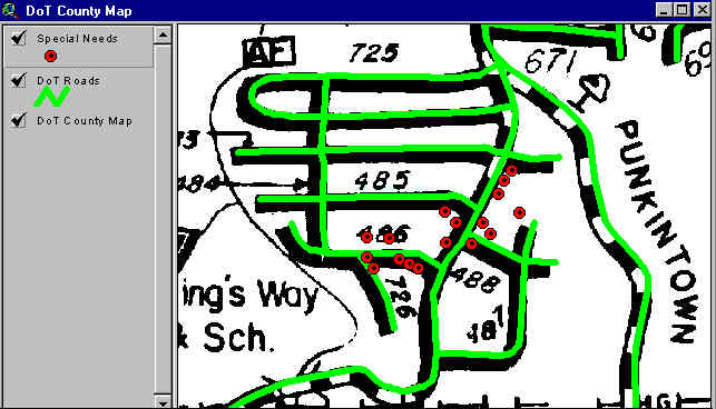
The Flood Recovery Program has developed a wide range of base map materials for use with a Virtual GPS. The first material considered by the Flood Recovery Program was rectified scans of Georgia Department of Transportation county road maps. These were actually used in the State Wide Well Study to provide a reference for the 3 mile radius areas for well sampling. However, the line thickness of these maps, the age of the maps, and their inability to be searched for road names make them poor candidates for a Virtual GPS. Reprojection of the scans to match other map data and the inability to update the scan in a reasonable manor are other undesirable features from a production point of view.
Figure 2. Sample Locations Displayed on Georgia Department of Transportation County Road Map
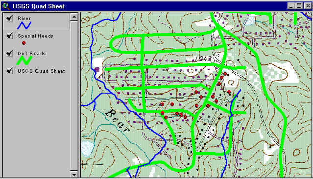
The county environmentalists are very familiar with U.S. Geological Survey (USGS) standard series topographic maps. The second reference base map that could be used is the Digital Raster Graphic(11) copies of those maps. While these have the additional enhancement of being in color and have more information than the county road maps, they also have the age, searchablity, projection, and update problems as the scanned county road maps. Their only benefit is their familiarity to non-computer field personnel.
Figure 3. Sample Locations Displayed on USGS DRG Topographic Map
The Georgia Department of Transportation is preparing road coverages for each Georgia county(12). These products are ArcInfo coverages that are the most current status of roads within Georgia. These coverages are updateable and easily reprojected. However, they are cartographically primitive and the operator can not just look at them and figure out where information is without the use of a map query. They are only affective for a Virtual GPS in combination with a more visually comprehensible base map.
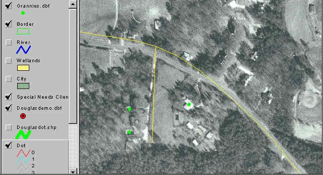
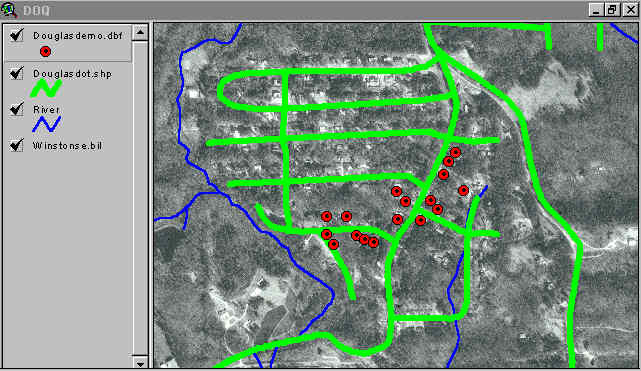
Lastly there are digital orhthophoto images for the State of Georgia(13). The digital orhthophoto produced by the USGS and used by the Flood Recovery Program is a black-and-white 1-meter ground resolution quarter quadrangle image. The accuracy and quality of these digital orthophotos must meet National Map Accuracy Standards at 1:12,000 scale for 3.75-minute quadrangles and at 1:24,000-scale for 7.5-minute quadrangles. These images have a mixture of the good and bad points of the three previous base maps. They are more current than the county road maps or the DRG maps, but are still 4 or 5 years old now. This is not good for urban areas or areas with high growth, but in most rural areas of Georgia they will still be good for the next 10 years in most cases. They are cartographically primitive, but have many landmarks and features to help the user orient themselves. As images they are difficult to update, but are recreatible on a periodic basis (if you have the money). More importantly, if the instructions say "second house on the right south of the intersection", you can usually see the house in the rectified image that you want to spatially locate. Maybe not with less than 2 meters RMS accuracy, but close enough for most public health applications.
Figure 4. Sample Locations Displayed on Digital Orthophoto with Georgia Department of Transportation Road Coverage
One of the first components for a Virtual GPS is a way to repeatedly record the coordinates of the features selected. Two Avenue scrips were written to accommodate this for the initial Virtual GPS method. The first script allows the user to select a new or existing dbf file for recording data. The second script captures the coordinates from the cursor, asks the user for the reference identifier, then writes a record with identifier and coordinate information. The user can later add the dbf as an Event Theme to view the located points.
The second component is the reference base map. For this application the Flood Recovery Program used the Georgia Department of Transportation county road ArcInfo coverages and rectified digital orhthophoto images. This gives a 1-meter per pixel resolution for locating objects and the most current road information for map query.
The third component is the hardware requirements to implement the Virtual GPS method. Each of the digital orhthophoto images in BIL format is approximately 50-megabytes. This puts the size of the data for a typical county in Georgia at 1.5-gigabytes and for the largest counties the data exceeds 3-gigabytes. This will put a strain on most mid-level desktop computers. If these images are cropped to remove overlap and cropped to the county boundary we expect to reduce the size of the data by 20%. However, resampling the images may remove such small features as driveways which would be used to identify buildings in tree cover.
The fourth component for a Virtual GPS is a trained user group. One of the Flood Recovery Program grant tasks is to "develop the skill capacity of district and local health departments to undertake disaster-related public health activities". The Program will be purchasing computers for each of the 19 health districts in Georgia with sufficient processing power and storage capacity to meet the needs of the Virtual GPS method. Copies of ArcView 3.0 have already been purchased and will be installed on these computers with the Virtual GPS scripts loaded. Training will be conducted regionally in the operation of the computers, use of ArcView within specific limits of application, and in the use of the Virtual GPS method.
One of the prime benefits of a Virtual GPS is cost. If the necessary base map data sets already exist and are available, the cost of implementing the Virtual GPS method becomes the cost of software and hardware plus training costs. As many organizations upgrade their computer resources to Pentium grade desktop computers with 32 bit capable operating systems, the cost of the ArcView software becomes the issue. Cost can be further reduced by use of mapping components, such as Esri's Map Objects(14), to add mapping capacity to existing applications.
One of the prime drawbacks of a Virtual GPS is cost. If the base map data does not exist or is not available costs for developing this data could be prohibitive. The Flood Recovery Program was a one time funding opportunity. The digital orhthophotos used by the Flood Recovery Program were obtained through participation in a joint funding agreement between the Georgia Department of Consumer Affairs and the USGS with approximately $2.1 million dollars being provided by both sides. The Georgia Department of Transportation has spent large sums to develop the road coverage. Without these preexisting data sets the Virtual GPS method would not be possible.
Another drawback is the updating of the spatial locations. Once a spatial location has been joined to a public health client record the commitment to update that spatial reference whenever the public health client moves must be made. A change of address flag in the public health data base must generate a notice to the appropriate health department to re-reference the client. The public health data base must also be modified to account for the spatial information and for the current validity of the spatial reference.
A third drawback to the use of Virtual GPS is that of confidentiality of health information. Public Health can protect client confidentiality by removing name and address from reports and data compilations of health data. Map display of this sanitized data may circumvent this protection by accurately locating the clients. This is a major legal liability.
There are a number of future enhancements that will have to be made to the present version of the Virtual GPS technique. The first enhancement will be to have real time display of the points on the road coverage in stead of adding the Event Theme later. The second enhancement will be to make the method applicable to lap top computers. This will be done by the addition of a third script that will ask the user to insert a specific CD-ROM containing the digital orhthophoto image required when the user has narrowed the scope of search to a small scale area.
This method will have applications in other areas besides public health. In emergency response to disasters there will be a need for evacuation of populations with medical or physical special needs. This method can be used to build a spatial data base of those Special Needs Clients for evacuation planning. This can include querying the data base for those that must be evacuated for a specific predicted tidal surge, preassigning clients to regional shelters based on transportation analysis or capacity, and management of the dispensation of clients after the disaster is over.
Putting a GPS unit in the hands of field personnel is not always the answer to locating things or people spatially. In many cases it is more trouble than not. If need requires that someone physically go to a place, that creates the opportunity to capture the spatial location of that place without sending a special field person for a second trip. This method is not for high accuracy needs, but it will function very well for a wide variety of applications. In the right situations it is highly cost effective and does not create an separate infrastructure of organization or personnel.
This analysis described in this paper was developed and supported 100% by federal funds from Centers for Disease Control and Prevention grant U1Q/CCU411900-01. Its contents are solely the responsibility of the author and do not represent the official views of CDC.
1. Tropical Storm Alberto: A WSR-88D Summary, W. D. (Josh) Korotky, J. Robert Michael, C. Eric Williford
2. Suspended sediment and agricultural chemicals in floodwaters caused by tropical storm Alberto, From U.S. Geological Survey Water-Resources Investigations Report 94-4183 By D.J. Hippe, D.J. Wangsness, E.A. Frick, and J.W. Garrett.
3. Case Studies: Floods - Disaster Recovery Response to Tropical Storm Alberto, Daryl Barksdale, Flood Assistance Coordinator, Georgia Historic Preservation Division, Georgia Deptpartment of Natural Resources
4. Georgia Emergency Management Agency Web Page
5. The Independence Day Flood of 1994, "Touching the Lives of Every Citizen, Every Day";, U.S. Geological Survey Yearbook Fiscal Year 1994.
6. Sokkia Corporatiion Spectrum Single-Frequency GIS Receiver Features
7. Statistical Evaluation of Flooding and Physical Well Characteristics on Wells Failing Chlorination, Lisa Phillips (Environmental Epidemiologist, Flood Recovery Program, Georgia Department of Human Resources Division of Public Health), to be presented at Esri 1997 Users Conference
8. Temporal Analysis of Private Drinking Water Wells to Evaluate Potential Aquifer Contamination, Roger Whitley (GIS Analyst, Flood Recovery Program, Georgia Department of Human Resources Division of Public Health), to be presented at Esri 1997 Users Conference
9. Evaluating Possible Human Exposure Pathways and Populations Relative to Hazardous Materials Sites, Scott Harris (Toxicologist, Flood Recovery Program, Georgia Department of Human Resources Division of Public Health), submitted to Esri 1997 Users Conference
10. U. S. Coast Guard Navagation Center - Answers to Frequently Asked DGPS Questions
11. NSDI Clearinghouse - Digital Raster Graphics
12. Douglas County - Roads - 1:31,680
13. USGS Digital Orthophoto Quadrangles
14. MapObjects LT - Put Maps in your Apps