By Donald A. Gordon
Abstract: Geographic Information Systems (GIS) play a critical role in precision farming. The integration of technologies including GIS, Global Positioning Systems (GPS), and imagery, allows a grower to track information relating to crops and map the location of features that affect crop productivity. The ability of a GIS to integrate information from many sources makes it particularly attractive for use in vineyard management and wine production (Harvell 1996; Lang 1996). For centuries, French vintners subscribed to the theory that the quality of the wine grape produced was driven in a large part by the environment. Terrior, the French term meaning from the land, is used to describe the qualities of a wine attributable to the geographic origin of its wine grapes. Factors that define geographic origin can be described discretely using a GIS and include soils, slope, aspect, growing season and degree-days. When combined with features such as clonal rootstocks, varieties, trellis systems, and irrigation systems, a specific variety of wine grape best suited to the site can be determined. Storing this information in a GIS provides growers a means to manage more effectively the inputs applied to a crop. The location, amount, and timing of these inputs can be tracked and mapped for reporting purposes to governing agencies thus relieving the grower of hours of tedious paper work by automating this task. Until recently, this technology has been used to maximize crop productivity for a given site, but in California, this technology is being used increasingly to maximize quality as well (Groves, 1997). Utilizing standard desktop computers and GIS, growers can quickly evaluate numerous scenarios and arrive at the optimal mix of quality and quantity ultimately benefiting the bottom line. This trend applies not only to viticulture, but is also gaining acceptance in citrus, apples, and other permanent crops. By combining these geo-technologies, growers can implement a cost effective management solution that improves profitability of the operation as well as minimize the amount of inputs necessary.
One example of a grower striving to attain this optimal balance is Ken Deaver of Deaver Vineyards. A fifth generation Amador County farmer, Deaver Vineyards farms approximately 320 acres of zinfandel in the Shenandoah Valley near the community of Plymouth.Located at about 1,200 feet elevation in the Sierra Nevada foothills, this region is renowned for its quality zinfandel. In addition to the vineyard, Deaver Vineyards also bottles and sells wine from a small winery located in the valley. Most grapes, however, are contracted to a larger winery. Vineyard blocks range in age from 120 years old to new vineyard plantings. Typical of many foothill regions, the area is represented by many soil types and associations. In an effort to improve the quality of the wine grapes while maximizing productivity, Deaver Vineyards plans to use a GIS to help manage the variability within his vineyards. In addition to managing the vineyard, the family oversees a winery, bed and breakfast, and a day lily nursery on the ranch. The ability to track inputs, cultural treatments, and yield were all requirements for the system. In order to accomplish this, a GIS was selected as a means of storing this information in spatial databases for mapping and data analysis.
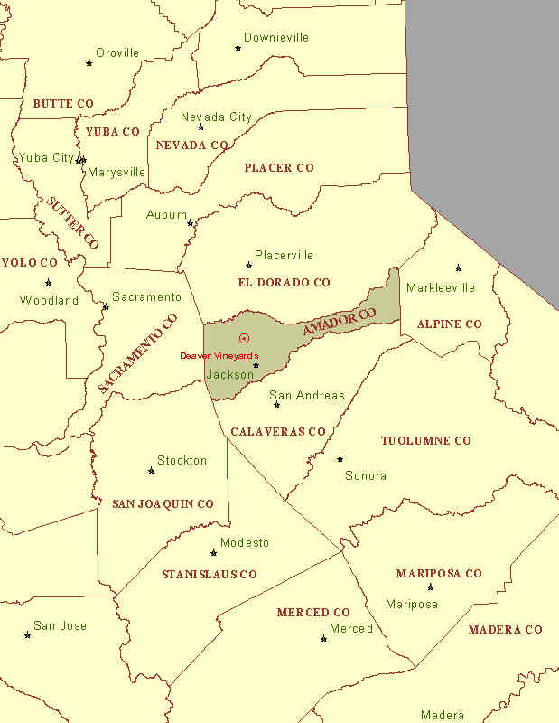
Figure 1. Location of Deaver Ranch.
VESTRA Resources was retained to provide GIS consulting and implementation services. Since Deaver Vineyards wanted to spread the cost of the new information system over several growing seasons, a comprehensive phased project implementation was prepared last year and presented. A user needs assessment revealed the level of accuracy, geographic extent, and data needs pertinent to Deaver Vineyards GIS implementation. Furthermore, several key GIS applications were identified, including property mapping, asset management, facilities mapping, and yield monitoring. Initially, the GIS will be maintained by VESTRA who will produce all maps and data upon request. Ultimately, a GIS computer will be installed at Deaver Vineyards for performing data analysis and map production. VESTRA will provide training, consulting, and data maintenance as required. GIS data will be delivered on CD-ROM or over the Internet directly to Deaver Vineyards.
Because vineyards are generally planted between 8- and 12-foot spacing, high-resolution aerial imagery was needed to acquire individual vine locations for the spatial database. Furthermore, this imagery would need to be controlled using a GPS to accurately locate control points for use in preparing the digital orthophoto. Custom aerial photography was acquired during the spring of 1996 prior to bud break and was used for the digital orthophoto. A scale of 1:12,000 was a compromise based on the geographic extent of the properties and the resolution needed to capture specific spatial features such as vines. Because of the cost of acquiring high resolution topographic data, USGS topographic contours were vectorized to create the DEM used in the orthophoto. Eight photos were scanned at 35 microns and used in the preparation of the imagery. The digital images, GPS control points, and digital elevation model were integrated to produce the orthophoto. The resulting true color orthophoto has a final resolution of three feet per pixel while a high-resolution (one and a half feet per pixel) single-band image will be used during the data-capture phase to locate vineyard blocks, irrigation systems, vines, and other detailed spatial features. Imagery was selected as the basis for this information because of the expediency of collecting several GPS control points and controlling the image versus collecting many GPS point for all features. This ensures a consistent geographic accuracy, but more importantly the relative accuracy of vines and other discrete spatial features can be maintained. Using imagery also provides a means of archiving spatial data and deriving digital features from it when budgetary constraints allow. The imagery also allows information to be conveyed on maps without the need to digitize it or capture it in the field using a GPS.
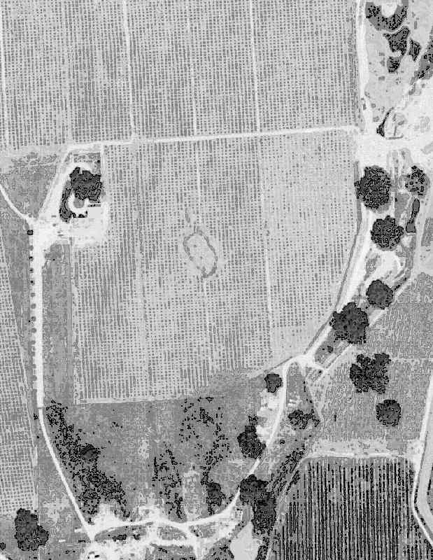
Figure 2. High-resolution aerial imagery depicting individual vine locations.
Base map GIS data were captured during the fall of 1996 from a variety of sources and integrated into a comprehensive GIS data structure. In addition to the topographic data used to create the orthophoto, VESTRA captured and attributed the following base data:
Base GIS features identifiable in the orthophoto were corrected and aligned to match the imagery. Additional annotation specific to Deaver Vineyards was captured as well. This data will be used for the generation of ranch maps. During the spring of 1997 additional spatial data were acquired from the orthophoto. Spatial data sets were built to represent the following features:
The user needs assessment revealed the importance of accurately locating the vineyard blocks, rows, and vines early in the development of the GIS, as information about the vineyard is tracked at these three levels. The vineyard block provides the grossest aggregation of information tracked for the vineyard. Information regarding yield, variety, age, and cultural treatments are applied at the block level and were being tracked in flat file data sets. By linking historical information tracked in the current databases to spatial data sets, an analysis of cultural treatments could be conducted providing new insights into the response of the various blocks to management treatments. Rows were digitized from the orthophoto and then processed to create the individual vines. Since vine spacing was known, each row was split based upon its length rounded to the nearest multiple of the spacing. Information tracked at the row level includes irrigation systems, trellis systems, vine spacing and other facilities management issues. At the vine level, information relevant to planning is maintained. This data includes the status of the vine, when it was planted, rootstock, and variety. This information can then be summarized to provide important planning data for replanting the following year or for tracking outbreaks of diseases or pathogens. Also, insect trap locations may be linked to a specific vine.
Other features too small to be seen using the digital orthophoto were located during the data collection phase for control points. In some cases, features such as wind machines would have been noticeable but were placed into operation after the imagery was flown. Other features such as neutron probe sites, well caps, and radio towers were collected using the GPS. These features also served as a quality control check to ensure accurate registration of the orthophoto.
Facilities management data layers were created to map and track various facilities critical to a successful vineyard management operation. Information on irrigation systems, wind machines, neutron probe sites, fuel tanks, and other infrastructure captured will prove useful for planning and tracking facilities data. Maintenance schedules can be developed to minimize down time and costs associated with unanticipated equipment breakdowns.
The design of the GIS also accommodates future expansion of functionality and data. It is anticipated that future soil tests will be incorporated into the GIS and modeled to build spatially explicit surfaces of nutrient concentration levels. Leaf petiole analysis is another important measure of nutrient status in the vineyard. Similar to linking pest trap locations to a vine, a leaf petiole analysis can be used to model nutrient uptake by a vine. This is an important indicator of the vine’s ability to interact with the soil and obtain the nutrients needed for crop growth and production. Data sets received from public agencies may be used as well. For instance, parcel data may be received from the county and incorporated into the GIS for land acquisition.
Several key applications were identified during the user needs assessments and the resulting GIS implementation. Spatial data sets were created to fulfill one or more of these applications. Using the GIS, Deaver Vineyards now has the ability to realize goals using the applications developed, mapping all property currently held. While this may appear a simple task, most farm managers do not have maps of their property. The ability to provide crews and contractors with ranch maps will reduce confusion and provide the foundation for future, more sophisticated GIS data collection and applications.
Another key application was facilities mapping. Using the GIS, Deaver Vineyards can track the inner workings of the vineyards such as wells, irrigation systems, and wind machines. Maintenance records can be linked to the map to provide important spatial information to mechanics. Field map atlases will be produced that are carried with each supervisor giving crew foremen quick access to vineyard data and block locations.
Yield analysis will be performed for both quantity and quality of the wine grapes. Using the GIS, Deaver Vineyards will be able to identify areas that have high yields as well as areas that produce quality zinfandel grapes. The ability to stratify and locate these attributes will allow Deaver Vineyards to optimize profitability in addition to producing a better wine.
Plantable acres are another important attribute of an efficient vineyard operation. Knowing how many acres are in production gives a grower an indication of the utilization of land resources. Rock piles, steep slopes, poor soils, and other factors influence how many acres can be placed into vineyard production. When designing a new vineyard, the GIS can assist a grower in several ways. First, the GIS can locate the areas that are unplantable because of soil conditions, slope, or other factors. Second, once the plantable acres are identified the GIS can be used to assist in designing the vineyard block layout. Once completed, the grower can then estimate the number of vines, irrigation supplies, stakes, and other components needed to develop the vineyard. With development costs running as high as $15,000/acre (Thompson 1996), a grower wants to purchase only what is necessary. Plantable acres are also used to assess the value of the land for tax purposes. Deaver Vineyards wanted to ensure that the county was not over-estimating the acreage in vineyard production. The GIS was used to arrive at a quantifiable value that could be fairly used for property taxes.
As agriculture enters into the 21st century, Deaver Vineyards hopes to leverage its GIS investment to further refine the vineyard operation and allow for better decision making. Deaver Vineyards anticipates using the GIS to help automate an early frost protection system using a network of wind machines and weather stations to monitor conditions in the vineyards. Similar to monitoring systems in oil refineries an early warning system for frost protection based on real time data collection will be in place. Ultimately, wind machines will be remotely operated from the office based on analysis of data received from the field. Similarly, irrigation scheduling will follow a similar path. When needed, a map will be generated showing where and what systems need to be activated. Long-term monitoring of the vineyards will be accomplished using remotely sensed satellite and/or aerial based imagery. Crop change detection will be used to assess the health and productivity of the vineyard.
An interesting application of the technology will be used to educate winery customers. A wine kiosk in the winery will be available for visitors to track the terrior of a particular bottle of wine from a selected vintage. By entering the variety and vintage, visitors will be able to create a map showing the soils, vineyard, and yield of a particular vintage. Other spatial information can be added to help add depth to the map. This interactive system will give customers the opportunity to query the GIS to locate vintages with particular characteristics they believe are important to quality wine production.
Today’s mapping technology can be used to provide cost-effective solutions for agricultural applications. Integrating GIS, GPS, and remote sensing technologies provides growers with the information they need at a scale they can use. As the accuracy and capabilities of these technologies improve, agriculture is poised to take full advantage of the benefits. As more farm managers adopt GIS as a means of managing spatially based information, the need to depend on anecdotal information will decrease. Farm managers will begin to make better decisions about inputs for crops and the management of variability within fields. GIS will help play a key role in integrating spatially based information from a variety of sources including yield monitoring, laboratory analyses, soils mapping, chemical tracking and many other data sources. For California agriculture, GIS can be used to not only improve yields but increase the quality of the crops produced as well. Farm managers can now evaluate trade-offs of quantity over quality. Management strategies can be selected that optimize growers’ objectives and provide for a sustainable resource.
Successful GIS implementations can be attained using a phased project approach. A user needs assessment is pivotal to identifying the GIS applications needed and the data to support them. Using this approach, growers can spread this technology investment over several seasons, allowing applications and data to be developed on a priority basis. Many farms benefit from basic mapping applications to better locate features on the farm and manage resources for optimal crop production. As GIS data sets continue to develop and mature, more sophisticated decision support systems can be implemented to provide growers with better information in a timely manner.
Groves, Martha. March 10, 1997. Ground Control: A crop of Satellites and Computers Is Helping Farmers Manage Fields More Efficiently, Los Angeles Times, Sect. D1 (Col. 1).
Harvell, Erik. August 1996. Pinpointing Information in Your Vineyard, Wine Business Monthly Vol. 3, No. 8): pages 45 - 47.
Lang, Laura. October 1996. Geotechnology Use Grows in California's Ag Community, Earth Observation Magazine, Vol. 5, No. 10: pages 16-20.
Thompson, Willard. June-July 1996. Central Coast Gold Rush, California Grower, Vol. 20 No. 6,: pages. 29 - 31.

VESTRA Resources, Inc.
962 Maraglia St.
Redding, California 96002
Donald A. Gordon, Senior GIS Analyst
Tel.: (916) 223-2585
Fax: (916) 223-1145
E-mail: mapmaker@vestra.com
Web Site: www.vestra.com