Milosz Stasik and Piotr Jankowski
University of Idaho
Department of Geography
Using Map Objects in the Internet-based Decision Support System

Main user interface window of SUDSS with tool buttons.
Milosz Stasik and Piotr Jankowski
|
|
|
|
|
Abstract
| The idea of public GIS involves the use of GIS tools
to help participants to understand the spatial consequences of proposed
projects, evaluate alternatives, and create new solutions. The prototype
software called Spatial Understanding and Decision Support System (SUDSS)
using Esri Map Objects was designed to facilitate a controlled Internet-based
experiment in collaborative group work aimed at solving a realistic landuse
planning problem.
Current information concerning SUDSS experiment is available at: |
Public participation in decision-making meetings on the local level has been practiced in democratic societies for a long time. Unfortunately, meetings frequently suffer from problems such as overemphasis on social-emotional rather than task activities, failure to adequately define a problem before rushing to judgment, and the feeling of disconnection or alienation from the meeting (Nunamaker et al. 1993).
Problems discussed during decision-making meetings frequently have spatial character. This kind of information creates special requirements for data presentation, manipulation, and analysis tools. Many elements of these tools can already be found in modern GIS software. This has led to recent interest in collaborative spatial decision making (CSDM) and public GIS also called GIS 2 (Densham et al., 1995; Sheppard, 1995). The ideas behind CSDM and GIS 2 involve the development and use of tools supporting both experts and stakeholders in understanding spatial consequences of locally important problems, developing alternative solutions to these problems, and resolving problems by choosing a consensual solution.
Nyerges and Jankowski (1997) distinguished three forms of social interaction involved in group work - collaboration, coordination, and cooperation. Collaboration occurs when participants agree to work on the same task. Cooperation takes place when participants agree to work on different tasks and share results. However, in a real-life situation it is sometimes difficult to achieve effective patterns of social interaction. Common problems that may impede the effectiveness of meetings include getting off the subject, lack of goals or agenda and individuals who dominate discussion (Mosvick and Nelson, 1987). The above problems may make a decision making process ineffective. To counterweight the above problems users need to be provided with a friendlier environment, free from a stress hampering user’s activity.
A prototype of public GIS called Spatial Understanding and Decision Support System (SUDSS), designed to accommodate a new approach to public participation in the decision making process, is discussed in the reminder of the paper.
The goal of developing a prototype for public GIS is to allow the use of software at different locations and at different times (distributed space and time). Users are no longer required to be physically present during a meeting. Instead of a fixed-time meeting, we propose relaxed time constraints allowing users to work on a problem within predefined time limits. Implementation of such an approach enables users to manage the time allocated for problem solving. This in turn promotes more focused, motivated participation in a virtual meeting.
SUDSS is based on server-client architecture. The server component, working under Windows NT 4.0 operating system, plays the role of an interface oriented towards simple data management (dumb server). The client (user) component, working under Windows 95 operating system, is a small stand-alone application that communicates with the database on the server. The data exchange between SUDSS client software and SUDSS server is solely based on the TCP/IP protocol providing reliable client-server connectivity using a packet-switched data transmission.
The current version off SUDSS prototype was implemented using Microsoft Visual Basic 4.0 Professional programming language with the addition of third-party software including Environmental Systems Research Institute’s Map Objects and Microsoft’s Internet Controls (beta version).
The selection of programming environment was influenced by the ease and speed of programming as well as high flexibility of software development during the software prototyping stage. Since SUDSS is a prototype, frequent changes of user interface favored a tool that would allow making such changes in a short time with minimal programming effort.
In order to achieve all necessary functionality of the software, the following additional elements were used during the development of SUDSS:
- Esri Map Objects versions 1.0 and 1.1a, and
- Microsoft Internet Controls Pack, beta version (ICP).
Map Objects, a library of OLE-compliant was used in order to allow the implementation of several GIS functions in SUDSS prototype without the necessity of linking SUDSS with an external GIS software package. Initially coupling the software with ArcView was considered. However, since spatial operations directly available to users are restricted to several editing functions, usage of large GIS tool would be unnecessary. In addition, since SUDSS is designed as a public GIS tool, the overall size of software and data is an important design factor. Using Map Objects helped to keep the size of SUDSS relatively small while providing map display and edition capabilities, as well as effective database access.
In order to make the drawing process easier and facilitate the computation of the quality appraisal score for a zoning plan, data was prepared in a form of a grid-like mesh consisting of over four thousand square polygons. The grid, invisible to the user, is comprised of the quarter sections of Public Land Survey System (PLSS) and overlaps with the map drawing canvas. Every polygon is acting as a grid cell and has precalculated values. User activity is limited to the selection of polygons and dedicating the areas which they represent to certain land use types. The selected the boundary lines of land use zone are automatically snapped to a grid.
Once selected, a map has colors assigned to every land-use zone allowing the user to keep track of the zoning pattern. All database activity, record selection and recalculation of data is conducted transparently to a user. Selections are translated in the background based on the attributes of a selected polygon.
This sophistication of user interface allows most users to benefit from easy access to GIS tools. Some users may have little or no prior experience with GIS (or even with a computer). In such case the simplification of the user interface seems to be the best way to provide the effective interaction of a user with SUDSS.
The above approach distinguishes SUDSS from currently available Decision Support software. Existing tools allow the user to discuss and vote on plans prepared earlier for the meeting. SUDSS permits the reliance on original input of stakeholders.
Microsoft Internet Controls eased the development process allowing the use of MS Windows sockets and access to network protocols. Usage of Internet Controls significantly reduces the amount of code necessary to implement network access. In addition, ICP provides easy access to other network tools, allows extending the software functionality.
Testing of the SUDSS prototype was conducted in the Spring of 1997, at the University of Idaho, and involved the engagement of student participants in a realistic situation of designing, evaluating, and voting on alternatives for a Latah county landuse zoning plan. The results of the testing will be described in a separate paper. Additional information about the experiment can be found at http://geogstu2.mines.uidaho.edu.
Earlier applications of group work software including GIS and visualization tools used the technology in various realistic decision situations (Faber et al. 1994, 1995). Such an approach, though it provided a good verification environment, is difficult to control and to experiment with the software. In this experiment a different approach has been taken in developing first a prototype and using it as an experimental research tool, learning from the experiment and using the results to develop a production software.
In order to take part in the experiment each participant is assigned to an experimental decision group. The group is an independent unit that deals with the problem without outside help. The experiment consists of four steps. Each step involves a different activity and allows the participants to focus on different aspects of the decision making process.
The first step, data acquisition, allows the participant to develop an in-depth understanding of the landuse zoning problem and helps to explore constrains that should be taken into account when developing a landuse zoning plan. This step provides the participant with the information, necessary to develop his/her own landuse-zoning plan. The data provided to the participants concerns Latah County (Northern Idaho) land-use zoning plan. The data is intended to provide necessary information for developing a meaningful land use zoning proposal in the form of a map. The discussion of the present situation, planning constraints and assumptions is provided to fully enable participants to engage in the design process.
Each group is given three days to complete the next three steps of the task, which lead to creation and selection of the group’s favorite land use zoning plan. The three-day time-interval is partially structured - participants face some deadlines. During the first 24 hours, each participant, working separately, is expected to create a map depicting his/her proposal of county zoning plan. The actual time spent on creating the map in most cases does not exceed four hours, but participants have the flexibility of choosing the time of work during the 24-hour interval. The 24-hour interval allocated to the first step gives participants the comfort of individual work place and time.
All participants are asked to create a zoning map based on personal interpretation of planning objectives and information provided in the first step of the experiment. Each participant has to designate three zones for land use (productive land, low density residential, and commercial/industrial/high density residential). All basic, yet necessary tools to create a map are provided in SUDSS software. Participants are not limited to any specific areas or shapes of zones, nor are they prevented from creating discontinued or scattered zone patters.
A logical place to begin working with SUDSS is the Exploration button in the main menu, which opens SUDSS Explore! window (see Figure 2).
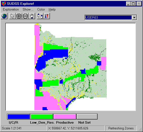 |
| Figure 2. The canvas of landuse map together with the landuse zone
designation buttons are used to delineate new landuse zone boundaries. |
The window offers a minimum of necessary tools that utilize Map Objects, represented by tool buttons, to create a map representation of land use zoning plan. The user can see plans created by other users but can only edit his/her plan. Line and polygon drawing tools are provided for the on-screen delineation of land use zone boundaries. Since the user is supposed to create polygon shaped zones, a point tool is unnecessary. The user is also provided with a typical set of tools allowing navigation within the map. These tools also allow him/her to display the full extent of map, zoom-in, zoom-out, pan the map, and split the map window into a double
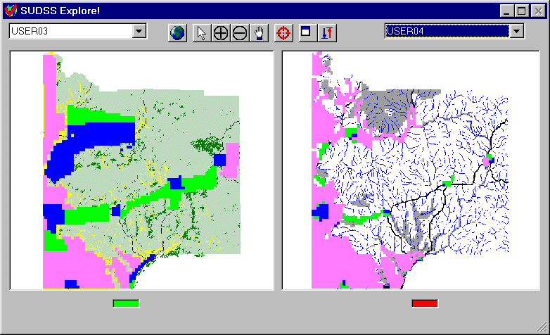 |
| Figure 3. One of visualization functions offered in the Exploration tool is split map window allowing the pairwise comparison of maps. |
Once the zoning plans are completed, the participants are asked to submit data to the server, which plays the role of the group communication center and plan repository. After the user submits a zoning plan, alternative plans can downloaded and compared with his/her own plan. Once the plan is submitted to the server, it can not be changed. The above steps comprise the first part of the experiment.
During the second step, the alternative plans can be evaluated both visually and quantitatively. A quantitative evaluation measures the performance of every plan on a number of evaluation criteria by expressing it in one summary score. The score, also called a final appraisal score, can be used to order alternative plans from best to worst. Evaluation criteria are the bases for computing the score for each plan. One can think of evaluation criteria as the operational objectives of a comprehensive land use plan. Each alternative plan receives a value representing its performance on each evaluation criterion. These values are then computed automatically by SUDSS. The outcomes are effected by how well location and shape of land use zones delineated by the user satisfy a given criterion. For example, the value of criterion "Compactness of area" measures how well land use zones compare with the ideally compact zone shape - in this case a square. The more complex boundary of a zone, the lower value received by a given plan on the criterion "Compactness of area". In order to calculate a final score for the entire plan, individual criterion scores are multiplied by weights that represent the relative importance of each criterion. Finally, the products of criterion values and weights are summarized. The sum yields the final appraisal score for the plan. Although all computations involved in the evaluation of zoning plan are carried out in the background by SUDSS, each user has to initiate the process by selecting from SUDSS main window the Evaluation button. This action opens SUDSS Evaluate! window (see Figure 4.)
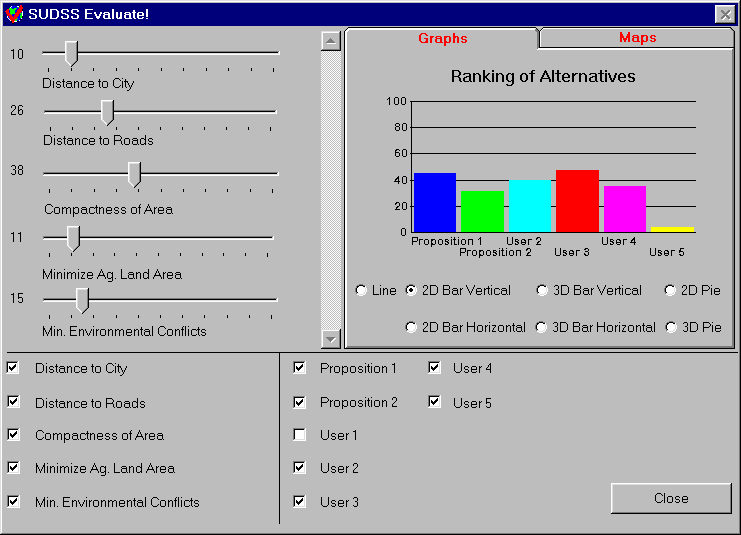 |
| Figure 4. Evaluation window provides the necessary functions for multiple criteria evaluation of alternative landuse plans. |
The upper left quadrant of the window provides sliders corresponding to the evaluation criteria. Users move the sliders to select a weight for each criterion. Each weight represents a relative importance assigned to a given criterion. The sum of weights must equal 100. The user also controls which criteria to include in the evaluation by checking the square boxes next to criteria names in the lower left quadrant of SUDSS Evaluate! window. Experiment participants have another 24 hours, following the plan development, to complete the zoning plan evaluation. In practice, half an hour is usually enough to determine the best criteria weight settings and to select the winning plan.
An important component of collaborative work is the fair evaluation of all plans developed by group members. Each group member can evaluate alternative plans, including his/her plan. Nothing prevents participants from tinkering with criterion weights and ultimately the results of evaluation, suppressing this possibility would force the participants to behave entirely "rationally" which is not always true in the decision making (Kaneman et al. 1986). Decision support tools built in SUDSS information and guidance to make rational and logical choices.
The results of individual evaluations are aggregated in the voting during the last 24-hour period. Voting on the rank of alternative landuse zoning plans is then carried out with the Vote window.
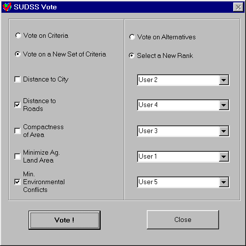 |
| Figure 5. Vote window allow the user to submit votes on evaluation
criteria (which evaluation criteria should be used) and order of alternatives (landuse plans). |
The vote function allows submission of the ranking of alternatives to the experiment server. Voting results can be viewed by the participants after downloading them from the server (see Figure 6).
Voting results are calculated by a ranked vote technique. The ranked-vote technique assigns ranks to alternatives based on the following rational: the higher position of an alternative plan on the voter’s list the higher the rank assigned. The voting position of an alternative is determined by adding the ranks for each alternative from every voter using the Borda social preference function (Hwang and Lin, 1987). This type of vote aggregation prevents a contentious candidate who ranks very high with some group members but very low with others from winning, and promotes a consensus candidate.
In the example of voting results presented in Figure 6, four out of five evaluation criteria have been selected by a group. Alternative #1 has received the highest score based on the ranked vote followed by proposition #1 and alternative #2. The measure of variation divided into three intervals informs about the degree of unanimity in voting for a specific alternative or the lack of thereof. Alternative #1 is clearly the favorite having not only received the highest score but also a high level of agreement among the voters.
Ideally, a consensual zoning plan emerges from voting similar to the example presented in Figure 6. In some groups, however, this may not be the case. In such an instance, group members may engage in a discussion of the merits of the preferred plan in an attempt to persuade others to change positions and ultimately voting results. Each group has its own private news group, implemented in SUDSS, to communicate and negotiate.
In this brief tour of SUDSS, we have demonstrated the software functionality using the example of experiment with space and time distributed public participation in landuse planning. SUDSS is still in the prototyping stage and will undergo additional experiments involving groups of stakeholders.
Data files and logs obtained during the experiment are currently undergoing statistical analysis, and final results will be posted on the experiment web page.
Prototype software that enables group collaboration across space and time using the Internet infrastructure called SUDSS has been created as a step towards the development of public GIS. Thanks to new software tools like Map Objects, it is now possible to create compact, yet specialized programs allowing inexperienced users to participate to a greater extent in solving local, spatially oriented problems. The SUDSS experiment intends to provide answers as to how people who are interested in solving local problems can contribute outside the confines of a traditional public meeting environment. It also provides an insight into the popularization of GIS.
An important concern is how far the process of simplification of user interface should go to provide an easy access to spatial information without loosing necessary functionality. Another issue is the level of geographical education necessary to work effectively with tools like SUDSS. These will be addressed during the future tests of SUDSS.
This research has been supported in part by a grant from the Idaho State Board of Education. The support is gratefully acknowledged.
Bibliography
Author Information
| Piotr Jankowski Associate Professor, Department of Geography, University of Idaho, Moscow, ID e-mail: Piotrj@uidaho.edu WWW: http://www.uidaho.edu/~piotrj/ tel: 208-885-6452 |
Milosz Stasik Ph.D. Candidate at the Department of Geography, University of Idaho, Moscow, ID e-mail: stas9593@uidaho.edu WWW: http://www.uidaho.edu/~stas9593/ tel: 208-885-4487 |