Authors: Barbara Quinn, Richard Allen, and Michael Sweeney
MOVING MAINTENANCE INTO THE MAINSTREAM:
THE CAGIS INTEGRATED GIS AND PERMIT MANAGEMENT SYSTEM
Abstract:
Coordination of information is essential for the benefit of the customer in creating and maintaining quality infrastructure and providing effective service delivery. In order to achieve it, three goals must be pursued by geographic information systems today: to utilize the system within an integrated framework, to communicate with and coordinate among the various agencies in the enterprises as well as between the enterprises and to deploy GIS data and technology widely to each desktop to facilitate re-engineered workflows to better serve the customer. True enterprise GIS projects are by nature comprehensive, detailed and expensive undertakings and the benefits can be elusive if continuous and timely maintenance of data is not performed. The lack of data maintenance and the inability to embed GIS technology seamlessly into the organization is most often the reason for its deterioration and for the failure to achieve the full organizational potential possible with GIS. Organizational and technical barriers exist blocking the necessary transition from manual paper based workflows to digital data capture at the source within a GIS framework. If not overcome these barriers yield results that are not cost effective, timely or accurate. Thus the GIS loses its value quickly and the benefits and interests in the investment decline or evaporate.
The Cincinnati Area Geographic Information System Consortium completed the initial development of a GIS data resource that was populated with a countywide data base of land and infrastructure information in 1992. To ensure that maximum benefit of the GIS as a tool for the community is achieved, the Cincinnati Area Geographic Information System Consortium of City and County Agencies and two private utilities has developed a strategy to maintain its investment in GIS data. GIS is one of the cornerstone technologies that is being used to develop an enterprise-wide integrated a computerized development tracking, permitting, inspection, work order, service request tracking and licensing system. The land, building, environment, and other GIS information shared by all CAGIS participants is created and maintained in the workflows that will be automated using GIS and permitting management technologies.
An enterprise approach is utilized which combines the technologies of GIS, database management software, specialized workflow software, document imaging, document management, the internet, video conferencing, and global positioning systems into an integrated solution. The project is now in its third year and is introducing not only improved services to the customer, but corporate databases are now beginning to be maintained by our employees while performing their daily work. Data entered one time at the source and made available at each desktop is becoming a daily reality throughout CAGIS.
The customers and their expectations of the permit processes were identified at the onset of the permit re-engineering analysis. The customers invited to participate in the analysis process included developers, owners, taxpayers, and government departments and divisions who depend upon data generated from the permitting workflows to deliver services. The results indicate that a savings of 5-7months in subdivision/development permit processing is achievable with additional service benefits of 15-70% per workflow via the implementation of automation and network communication. This paper summarizes the design, implementation and benefits achieved to date by the integrated permit management system.
This paper describes the history of the Cincinnati Area Geographic Information System (CAGIS) whose staff served as the project management team and the re-engineering and technical approaches supporting the Integrated Permit System project design and implementation.
CAGIS
The mission of the Cincinnati Area Geographic Information System (CAGIS) is to create innovative system supports for the processes of creating, managing, and improving the area's infrastructure which also result in improvements in the way business is done in the participating agencies.
CAGIS is a consortium comprised of the agencies in the City of Cincinnati and Hamilton County, the Cincinnati Bell Telephone Company and Cincinnati Gas & Electric. The specific departments served within the City of Cincinnati are: Planning, Public Works, Building Inspections, Water Works, Metropolitan Sewer District, Stormwater Management Utility, Real Estate, Parks Commission, Recreation, Economic Development, Neighborhood Services, Fire Department, Public Safety and Health Department. The departments served within Hamilton County are: Regional Planning, Rural Zoning, Building Inspections, Public Works, Hamilton County Engineer, Park Commission, General Health District, Soil and Water Conservation, Emergency Response, and Hamilton County Communications. Any department of the City, County, or private utilities is eligible to receive CAGIS services. Other Agencies and Communities within the County are showing interest in becoming full members of the CAGIS Consortium and many will join in the next months and following years, particularly as data communications to these outlying agencies is enabled.
CAGIS is managed by a ten-member Board comprised of representatives from the City of Cincinnati (Directors of Buildings, Planning, Public Works, and Water Works); Hamilton County (Directors of Administrative Services and the Metropolitan Sewer District, County Engineer and Executive Director/Secretary of the Regional Planning Commission); and Vice Presidents of Cincinnati Bell Telephone and Cincinnati Gas & Electric Company.
The CAGIS GIS is a "decentralized" system design. All data maintenance activities are performed by the various City/County departments and utilities. The CAGIS Consortium is supported by a small centralized staff of twelve technology experts augmented by students from the University of Cincinnati. The staff's mission is to administer the shared CAGIS database, develop GIS applications for the consortium, administer the geographic integration framework, manage the CAGIS network, design and implement the management and data capture methodologies supporting data maintenance, and establish standards for data sharing.
CAGIS was initiated as the result of an analysis of the mapping systems supporting the infrastructure in Cincinnati and Hamilton County during the mid 1980's by the Schmale Commission. It was identified that the private utilities, City and County each developed maps of different scales requiring time consuming modifications in order to accomplish any type of construction project. A consortium was formed between the City of Cincinnati, Hamilton County, Cincinnati Bell Telephone and Cincinnati Gas & Electric Company, now CINERGY, with a mission to develop a shared automated basemap that could be used by all of the various enterprises in the community. The development of an automated mapping system was begun in 1989 and completed in 1992 at a cost of twelve million dollars.
In 1993 the CAGIS Board established a new vision for CAGIS. The description of the project as an "automated map" was dropped in favor of a new vision that the system was to support and enable government and utility agencies to "change the way that business was done." It was already noted in 1993 that focusing only on changing the mapping component of the involved organizations was too narrow a focus. There were visionaries in the City and County that recognized a far greater potential in GIS technology.
In 1994 the County Administrator , the Cincinnati City Council, and the City Manager directed CAGIS to deploy the GIS data and capabilities to the desktop and to utilize the system to improve coordination among the various departments in the enterprises as well as between the enterprises. The CAGIS Board hired a new administrator with the directive that a means be found to update the CAGIS database in a cost-effective manner. In addition, the original software supporting CAGIS, Synercom, was being discontinued and migration to a new software platform was required. In July, 1994, the Consortium agreed to migrate to the Environmental Systems Research Institute (Esri) family of GIS products. It was determined that a migration to Esri technology would provide the greatest flexibility in future application design and with the integration plans that were being developed and so that task was initiated. By December 1995 the migration was complete.
The members of the CAGIS consortium recognized in 1994 that they were not maintaining their newly digitized twelve million dollar GIS database because it had been developed without a strategy for its continuing maintenance and without consideration of how the GIS was to be incorporated into day to day business. Data accuracy and quality, was beginning to deteriorate because it was not being maintained as part of the workflow where the data was generated. The County Administrator , the Cincinnati City Council, and the City Manager directed CAGIS to deploy the GIS data to the desktop and to utilize the system to improve coordination among the various departments in the enterprises as well as between the enterprises. It was further determined that many of the key data resources required extensive work just to enable them to support the planned automation of various workflows.
CAGIS also began to recognize that the database, developed as a 'computerized map', lacked many of the features that would be needed to support a fully functional GIS. Special target teams were created to perform maintenance and upgrade on the parcel and addressing data to increase the functionality of the database.
Other key technologies, such as enterprise data base management systems, document imaging, automated permitting technologies, and imaging were identified. Department users, working in teams with CAGIS staff, began acquiring these technologies, training in their use, and integrating them with the GIS to create a foundation for application design.
"Mainstreaming Gis Maintenance" - The Project
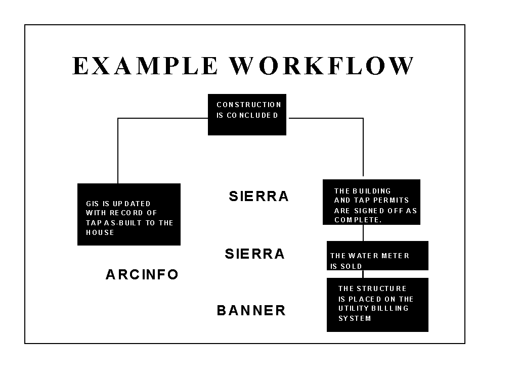
In 1994 and on several occasions since, the City Council and County Commissioners have been approached by customers with requests for review of the City's processes impacting individuals and businesses. The vision adopted by the CAGIS Board to resolve all of these issues was to build the maintenance activities into the organizations' various work processes that change the map database - ie., permits, work orders, service requests, complaints and capital improvements. Well into implementation of the "vision" by 1997, "mainstreaming GIS maintenance" is proving that it can accomplish all of the above goals. Existing workflows were analyzed and the problems facing customers were confirmed as being those related to disjointed, redundant processes. In 1994, the Metropolitan Sewer District retained the services of Mr. Richard Allen, of MAGIC, to develop an integrated framework to improve the coordination of sewer data with data produced by other departments with whom it interacted. The resulting design provided for integration of nearly any local government computerized data, including legacy data, into a flexible and scalable framework that could support a broad range of operational, management and policy applications. CAGIS has implemented the "Geographic Integration Framework" design developed by Mr. Allen as the keystone of both the GIS and the permits project and continues to evolve its design.
In response to the directive to achieve both database maintenance and organizational coordination objectives, CAGIS proposed utilizing GIS technology to automate the primary workflows which contribute to changes in the property and infrastructure inventories which the database contains. In 1995 the City and the County began the first stage of implementation of automation of the four workflows which change the fabric of the community; permits, work orders, capital improvement projects and complaints. The permits phase was selected for implementation because the majority of the community change activities resulting in updates to the CAGIS database were captured via the subdivision, building, and street cut opening processes in the City and the County. In addition, the permits workflow was identified as demanding the most "inter and intra departmental collaboration" .
Project Design: The Workflow Analysis Phase
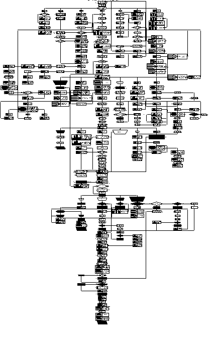
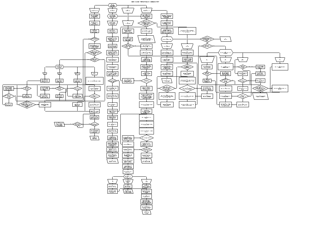
An initial project phase was to gather data on the permit processes currently in place and how well they supported coordination between departments and between the enterprises. Workflow re-engineering was the tool used to perform a analysis of the paper and existing automated workflows. Over 120 workflows were assessed. The City and the County discussed the Permit System interface with developer, engineering, architect and builder customers. Internally, process analysis involved task holders, process owners, and middle and top management. Examples of two of the process analyses are included in the paper, a zoning review process and a subdivision process. This phase of the process began in 1994 and continues.
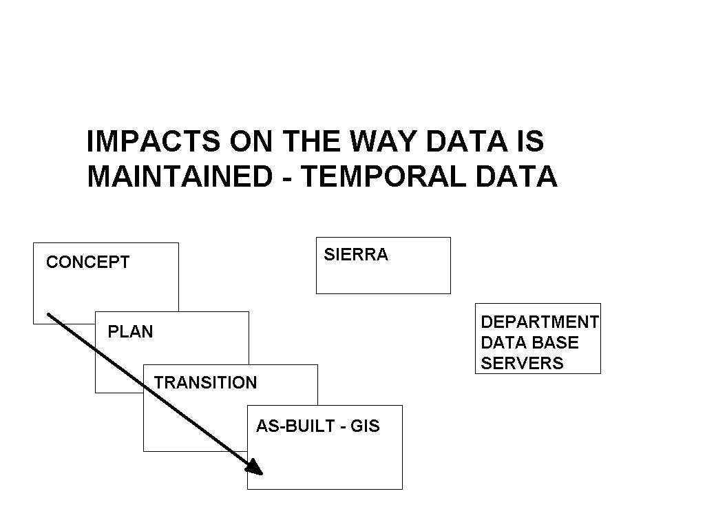
A by-product contribution of the re-engineering phase of the project was that it prepared the organization for change. Process holders identified and analyzed the reasons for problems that were being encountered and communicated the need for a change across a large number of employees from directors to process participants and customers. Design concepts and goals were clarified, i.e., data entered one time at the source, the need for integration of data derived from diverse sources and for integration between various softwares that would be used for application design. One key ingredient for success identified during the re-engineering phase was that of an organizational behavior labeled "silo" by the participants. This behavior, a department acting in its interest without regard to the "interest" of the organization as a whole, had to stop. These objectives became identified goals not accomplished objectives. As with much of the organizational change side of this project, the goals have become a journey for the participants, not a destination. CAGIS has assumed the responsibility for leading the process re-engineering. The organizational position of CAGIS as "outside" the various organizations, "owned by none and thereby owned by all" has assisted in making this role successful.
Re-engineering Project Approach
Processes were "re-engineered" utilizing standard organizational principles; sequential tasks were made parallel, redundant tasks and those no longer contributing to the service goals of any customer were removed. Using these approaches time savings of between three to seven months were identified in both the City of Cincinnati and Hamilton County development permit processes. However the study went deeper than assessment for process re-alignment to performing a detailed analysis of how well the existing systems supported organizational coordination. The detailed task analysis was supported by times assigned to tasks by process owners and entered into "AllClear Process" a workflow analysis software package. In addition, each task was identified as to the process role it performed i.e., was the task related to routing, logging, scheduling, seeking other departments' data, seeking their own department's data, reviewing, creating data, or processing a fee.
The Maze of the Hamilton County Subdivision Process 1995
Cincinnati Zoning Review and Appeal Processes (1995)
The analysis that has provided the facts required for the project "business case" as well as the insight for computerization approaches that would produce the end objective - streamlined and coordinated processes. Consensus was achieved in the City and County through the re-engineering process on the organizational and technical visions for the permit application in the land and infrastructure agencies.
A description of the analysis components computed for a typical workflow is presented below. One hundred simulation path cycles were run to account for the probabilities that different workflow routings were taken depending upon various conditions being present in a permit application. The average task group time in hours was calculated. As mentioned above, each task was identified as to the process role it performed i.e., was the task related to routing, logging, scheduling, seeking other departments' data, seeking their own department's data, reviewing, creating data, or processing a fee. The percentage that total time allotted to each task component represented of the total average task time was calculated. The annual task impact was calculated as the number of permits issued by the department during a year times the average number of hours calculated for a single issuance process times a 50% goal reduction in software supported tasks except routing tasks where the impact of network communication was projected as a 90% improvement over inter-office mail. Any task roles identified as incapable of being supported by automation, such as statutory commission reviews, etc., were identified.
The total task time without technology was calculated as well as the total task time after technology.. The percent of the original tasks that could be benefited by technology averaged 90%.
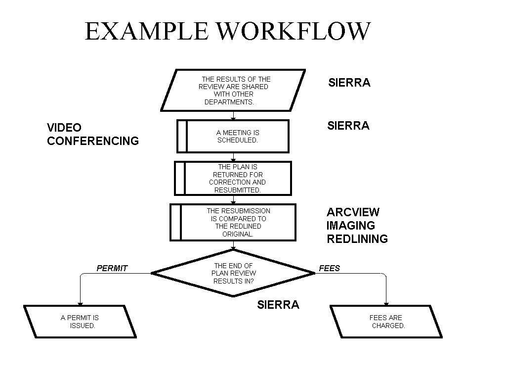
The City of Cincinnati has identified that the impact of re-engineering on the Cincinnati development process alone ranges from five to seven months for the average subdivision permit excluding the impacts of automation. Analyses demonstrate 15% to 70% automation related time savings depending upon the workflow component. For example, the necessity to have a customer make a separate visit to the Department of Public Works for street opening, street blocking, etc. permits related to Building Permits has been removed. The Building and Public Works Departments now issue a joint permit at either department with each department collecting fees for the other. The Building Department will be issuing "combo" permits for plumbing, heating, and building work where appropriate rather than 3 separate permits, etc. The Cincinnati Water Works will integrate its permit procedures with those of the City and County subdivision and building permit processes. Historically its processes were separate from and sequential to the processes of the other departments. Achieving parallel reviews for this agency alone results in 3-4 months savings in development review time. The utility billing system (the final step in the facility permit process) was found to have errors resulting from the failure of the billing process to manage a one to one relationship with the permit system in sewers and water. The Cincinnati Metropolitan Sewer District has calculated its historical losses at over five million dollars with an annual benefit of one million dollars in additional sewer revenue. Problems were identified in maintaining consistency in building use codes between buildings, sewers and water which resulted in additional millions of lost billing revenues. These problems are being corrected with the integration framework and workflow management technical approaches described below. With automation there is the added bonus of full incorporation of all of the land and infrastructure changes in close to real time in the corporate database available to all employees as an improvement over records ranging from 2 -5 years in age and which therefore are missing key data.

Technology
As stated above, the CAGIS project began as an automated mapping project supported by Synercom. In order to began the process of maintaining the database via the work processes which change it, the original graphic and address databases have undergone significant change. They have been transformed into a GIS. CAGIS expanded the role of GIS technology from automated mapping to a strategic analytic and organization decision and operations support tool. A series of user technology visioning workshops were conducted with topics ranging from enterprise technology and agency wide approaches, to a broad range of application and technology demonstrations that were conducted by the users themselves.
Technical readiness for the implementation of Maintenance Mainstream Project:
The City and County unanimously selected Sierra Permits PLUS as the workflow software for the Maintenance Mainstream Project. Sierra Permits is an activity tracking software which can also be used for complaint, capital improvement, and work order tracking.
Document management and scanning were identified as strategies to be used to bring both new and historical data into the maintenance system. The Sierra software for workflow management and the imaging software seamlessly integrate with the Esri software component which support the GIS requirements of the workflow in CAGIS. All software selections have been reached via consensus between the City and the County.
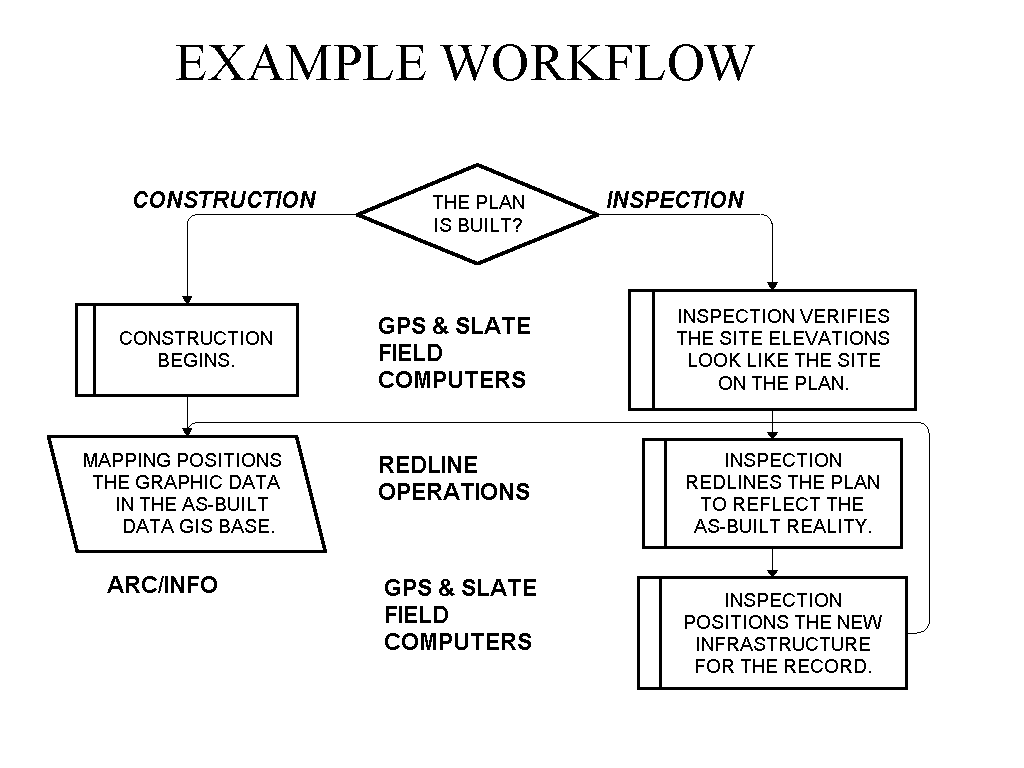
CAGIS has worked with client agencies to test Global Positioning System (GPS) technology for field data collection of facility as-built, permit, and topographical data.
Project Present Status - Sierra Implementation:
Agencies in the County are completing inter-agency workflow agreements that will serve as living documents upon which all future work is based. These documents spell out both what the agency agrees to provide workflow partners as well as what is expected of those partners in return.
The City of Cincinnati is proceeding to implementation during the month of may. The modularity of the project technical design is a strong asset during implementation. The breadth of technologies being introduced into the environment demands spacing the introduction of technology and the achievement of efficiency paybacks has been occuring at each step.
The Sierrra Permits Plus product encompasses a unique database design flexible enough to meet the integration and communication demands of both the variety of players and the coordination goal of the project. Departments involved in street opening permits are able to provide their utility customers access to their screens for the purpose of application while retaining security over fee payments, as-built measurements and document issuance.
The CAGIS project has made enormous strides over the last two years. CAGIS has successfully migrated from a mapping oriented technology to an enterprise wide integration of a number of technologies that are being used to tranform the way CAGIS participant do business. Esri GIS technology in combination to the approach CAGIS has adopted for embedding it into the lines of business while simoultaneously tranforming the framework for delivering services has been key to the materializing vision. CAGIS now has almost three hundred desktop and workstation GIS seats servicing that are used by four to five hundred users. Many of these are using GIS on a daily basis. Their efforts are begining to result in the embedded, on-going maintenance of the GIS data resources. CAGIS has been successful integrating many technologies from GIS, Automated permitting technologies, document imaging, inter and intra net capabilities, and many others into an environment that provides on demand applications. CAGIS even has a walk-in service that server fifteen to twenty five customers a day providing across the counter data and products for only the cost of the personnel time involved. Many participating agencies are providing similar services. The on-line shared GIS data resource inventory has grown to include nearly two hundred primary coverages and hundreds of other data resources. Applications ranging from operational activities such as service request and complaint processing, dispatch, and project tracking are being directly supported. Management resource allocation and policy applications are now being done on a on-demand basis. Many of those that formerly scorned the use of GIS technology now will not do without it.
The implementation is currently impacting several hundred throughout CAGIS and the community and those numbers are growing rapidly. As more and more of the workflows become automated and supported with the integrated technologies, this number is expected to grow to several thousand over the next two to three years. This project has brought together persons who had never spoken with one another before, let alone coordinated behavior. More importantly the project has brought excitement and change to a community which heretofore most frequently associated itself with the Mark Twain quote; " When the end of the world comes, I want to be in Cincinnati. Everything there happens twenty years late." No longer is that true.
AUTHOR INFORMATION
Barbara Quinn
Director of CAGIS
138 E Court St
Suite 1003
Cincinnati, OH 45202
513 - 352 - 1641
Michael Sweeney
Deputy Director, Metropolitan Sewage Department
1600 Gest Street
Cincinnati, OH 45204
513 - 244 - 1520
Richard Allen
Owner
MAGIC
2525 S. Shore Dr. 7-A
Milwaukee WI 53207
513 - 769 - 1051
Richn757lg@aol.com