Given reasonably accurate, 1:20,000 digital representations of roads and streams within 90 drainage basins of southern Alberta's Rocky Mountain eastern slopes, we required an efficient GIS-based method to count the number of stream crossing-points of roads. In general terms, we needed the GIS to provide the points of overlap of two coverages with line topology, but to ignore any intersections contained within each of the line coverages: we did not want stream confluences and road intersections included in the total. This challenge is apparently not met directly by any of the standard overlay functions of ArcInfo, so we relied upon a combination of the "clean" and "intersecterrors" commands in ArcInfo Version 7.03 to derive the required information. Stream-crossing information was then used in a GIS-based watershed analysis that considers 11 other land-use variables, including road densities, proximity of roads and logging units to streams, extent of logging, soil erodibility, steepness of slope and proximity of development to fish-bearing streams.
Roads are by far the greatest source of sediment to streams in developed forest watersheds (Leathe and Enk 1985, Waters 1996:24). This sediment is delivered to streams mainly at stream crossings (Shaw and Thompson 1986, Case et al. 1994, Clarke and Scruton 1997), making stream crossings a potentially useful and easily-measured predictor of sediment delivery to watercourses (Case et al., 1994, Eaglin and Hubert 1993, BC Forest Service 1995a, 1995b). Because roads are an inevitable adjunct to land development for any purpose, measures of the frequency of stream crossings might also serve as an easily-measured indicator of the overall impact of human development on watercourses within a watershed. This paper describes and evaluates a method for counting stream crossings in ArcInfo, and describes how we used this information to help us assess cumulative effects of land-use on 90 watersheds in a 2455 sq. km. study area, the upper Crowsnest and upper Oldman-Livingston drainages in southwestern Alberta, Canada.
1:20,000 digital representations of hydrography and linear disturbance features within the study area were purchased from Alberta Environmental Protection. Linear disturbance features (hereinafter referred to as roads) included roads, transmission lines, pipelines, seismic exploration lines and rail lines. In previous attempts at summing road crossings using similar data for smaller study areas, we had hand-counted the stream crossings directly from paper maps. Confronted with 5,453 km of streams and over 4,100 km of roads within the southwestern Alberta study area, we were immediately convinced of the likely inaccuracy, and probable futility, of attempting to hand-tally the crossings.
ArcInfo at Version 7.03 has no standard overlay functions that return the points at which one line coverage intersects another, so our first attempts at automation lead us to conversion of the stream and road arc coverages to grids. We added stream and road grids together, and counted the number of grid cells containing values obtained by the addition of a road cell and a stream cell. Unfortunately, this method gives widely differing results depending on cell size, and even with cells as small as a few meters, significant errors are inevitable, particularly where roads closely parallel streams, or approach them without crossing. We concluded that the grid method seems appropriate only where one is attempting to quantify or depict the proximity of roads and streams, not the actual crossing of streams by roads.
As an alternative to conversion to grids, we developed the following method of counting stream crossings using vector data directly: 1) We used the "clean" command with the "polygon" option to introduce nodes at all intersections within the stream and road coverages. This removes all non-noded stream confluences and intersections of roads with roads. 2) We appended the cleaned stream and road arc coverages together with the "notest" option. 3) With a watch file capturing the output, we used the "intersecterrors" command on the appended coverage. In this case, this command returns the X and Y coordinates of all points of intersection of the road and stream coverages 4) Using a database program in a Microsoft Windows NT environment, we manipulated the captured output from the "intersecterrors" operation to list the coordinates of all intersections in Arc generate format (such a manipulation could also be accomplished in AML by selecting text from character strings on each line of the output file). 5) We applied the "generate" command to the manipulated text file to create a point coverage of stream crossings.
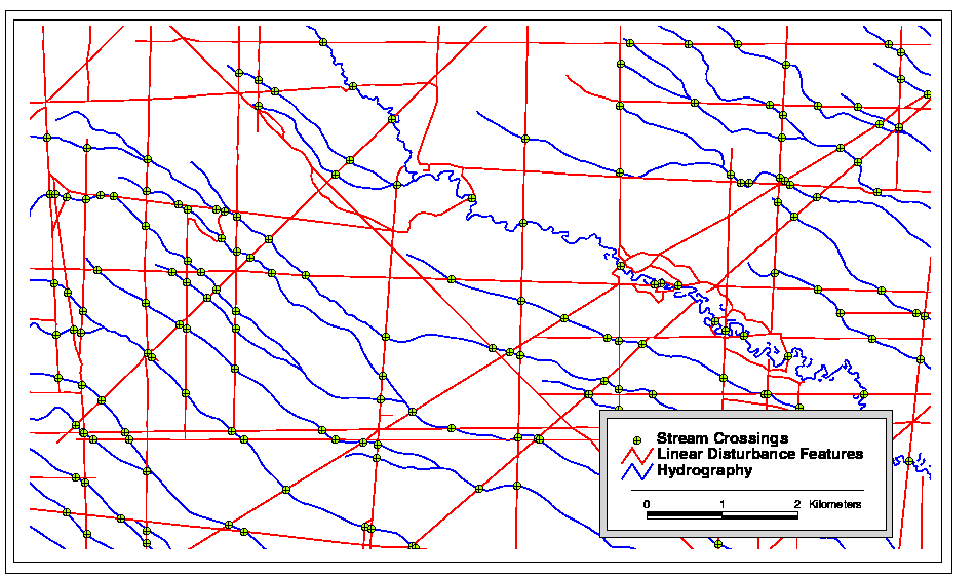
Given the newly generated point coverage representations of stream crossings, we then totaled the number of stream crossings and the total area within each of the watersheds in the study area, and expressed stream crossing density as the number of stream crossings per square kilometre. The stream crossing locations were checked by selecting 20 randomly-located 100 square kilometre windows within the analysis area (typically with 100-200 stream crossing points), and overlaying the crossing points with stream and road coverages: no spurious stream crossing points were found (see Figure 1)
Figure 1. The intersection points of streams and roads within a small section of the study area.
A second set of indicators is used to evaluate the potential for changes in peak flows due to land-use. These indicators are a peak flow index derived from the area of land that has been clearcut or equivalent to clearcut, road density in the upper part of the basin (higher in elevation than the H60 line, above which lies 60% of the basin area), and total road density. These too are scored and combined into one overall assessment of peak flow hazard to the basin. Other simple indicators are used to evaluate the impact of riparian logging and mass-wasting effects on the basin. Finally, surface erosion, peak flow, riparian logging and mass-wasting hazard evaluations are combined in to two-way matrices to help interpret what risk the interactions among the various hazard classes might pose for the watershed.
The peak flow and surface erosion indicators for all 90 watersheds in the study area combined are shown below for the most recent decade analyzed (1990). Impact scores may be categorized as <0.5, low impact; 0.5 to 0.7, moderate impact; and >0.7, high impact.
Peak flow index					0.1
Road density above H60				0.7
Total road density				0.5
OVERALL PEAK FLOW HAZARD			0.4

Roads on erodible soil				1.0
Roads < 100m from streams			1.0
Roads <100m from streams, erodible soil		1.0
Stream crossing density				1.0
Total road density				0.6
OVERALL SURFACE EROSION HAZARD			1.0
The hazard from peak flow changes and surface erosion increases together provided the best estimate of overall cumulative effects of land-use in our study. When this interaction was evaluated, 31% of the 90 watersheds showed a very high potential for damage, and nearly 66% showed a moderately high potential for damage. Only 3 small basins in our study area lacked significant development and showed low potential for damage.
Because surface erosion hazard evaluations in the IWAP are all road-related, road crossing density alone can often be used as an adequate first estimate of overall surface erosion hazard. When we compared road crossing density to overall erosion hazard scores for the 90 study watersheds, 83 gave identical evaluations in terms of class (low, moderate, high), and only two gave widely divergent (i.e., low versus high) evaluations.
Road crossing density was less closely related to the combined potential for peak flow changes and surface erosion hazard. Nevertheless, high scores for stream crossing density were associated with at least moderate potential for damage from the combined effects of peak flow increases and surface erosion hazard in all 90 of our study watersheds.
BC Forest Service. 1995b. Interior watershed assessment procedure guidebook (IWAP) Level 1 analysis. BC Environment, Government of British Columbia, Victoria, BC. vi + 82 p.
Case, P., T. Clark, J. Maxwell and T. Sale. 1994. Spatial analysis of the cumulative effect of land management activities on stream water quality within forested watersheds. Proceedings of the Fourteenth Annual Esri User Conference 14:383-399.
Clarke, K. D., and D. A. Scruton. 1997. Use of the Wesche method to evaluate fine-sediment dynamics in small boreal forest headwater streams. North American Journal of Fisheries Management 17:188-193.
Eaglin, G. S. and W. A. Hubert. 1993. Effects of logging and roads on substrate and trout in streams of the Medicine Bow National Forest, Wyoming. North American Journal of Fisheries Management 13:844-846.
Hicks, B. J., J. D. Hall, P. A. Bisson and J. R. Sedell. 1991. Responses of salmonids to habitat changes. pp. 483-518. in W. R. Meehan, editor. Influences of forest and rangeland management on salmonid fishes and their habitats. American Fisheries Society Special Publication 19.
Leathe, S. A. and M. D. Enk. 1985. Cumulative effects of micro-hydro development on the fisheries of the Swan River drainage, Montana. Volume 1: summary report. Bonneville Power Administration, Division of Fish and Wildlife, P. O. Box 3621, Portland, OR 97208. 114 p.
Newcombe, C. P. and D. D. MacDonald. 1991. Effects of suspended sediments on aquatic ecosystems. North American Journal of Fisheries Management 11:72-82.
Newcombe, C. P. and J. O. T. Jensen. 1996. Channel suspended sediment and fisheries: a synthesis for quantitative assessment of risk and impact. North American Journal of Fisheries Management 16:693-727.
Shaw, G. L. and D. Thompson. 1986. Water quality management and timber operations in southwest Alberta. Report prepared for the Alberta Environmental Research Trust Fund, Grant #T0953, by the Faculty of Environmental Design, University of Calgary, Calgary, AB. 75 p.
Swanston, D. N. 1991. Natural processes. pp. 139-179. in W. R. Meehan, editor. Influences of forest and rangeland management on salmonid fishes and their habitats. American Fisheries Society Special Publication 19.
Waters, T. F. 1995. Sediment in streams: sources, biological effects and control. American Fisheries Society Monograph 7:1-251.
David Mayhood
President, Freshwater Research Limited
1715 Seventh Avenue NW, Calgary, AB, T2N 0Z5, Canada
(403) 283-8865, (403) 283-9446
fwr@nucleus.com